


photo credit: North Texas Tollway Authority
| Location | North Dallas, Texas |
|---|---|
| Project Sponsor / Borrower | North Texas Tollway Authority (NTTA - formerly Texas Turnpike Authority) Texas Department of Transportation (TxDOT) North Central Texas Council of Governments (NCTCOG) Adjacent counties and cities |
| Program Areas |
|
| Mode | Toll Highway |
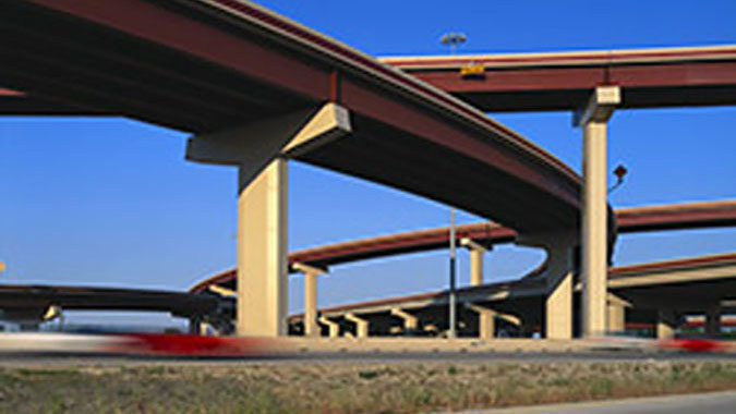
| Description | The President George Bush Turnpike (PGBT) is a six-lane, 30.5-mile circumferential toll highway connecting various cities in the northern part of Dallas County and portions of neighboring Denton and Collin Counties. It extends from just north of Belt Line Road in Irving, near Dallas-Fort Worth International Airport, to SH 78 in Garland, northeast of Dallas. This original segment was completed in 2006. The Eastern Extension is a 9.9-mile segment continuing from SH 78 to I-30, including a one-mile bridge over Lake Ray Hubbard, that opened in December 2011. The PGBT Western Extension (SH 161) continues south from SH 183 in Irving for 11.5 miles to I-20 in Grand Prairie. The original portion of the PGBT from I-35E to SH 78 is being widened in phases to four lanes in each direction, with construction having started in May 2015 and planned through late 2019. Widening to four lanes between the western extent north of Belt Line Road to I-35E is in the planning phase. |
| Cost | Original PGBT - $599 million Eastern Extension - $958 million |
| Funding Sources | Original PGBT
Eastern Extension
|
| Project Delivery / Contract Method | Design-bid-build for both projects |
| Private Partner | None |
| Project Advisors / Consultants | Original PGBT
Eastern Extension
|
| Lenders | Bondholders |
| Duration / Status | The original PGBT opened in phases between 1998 and 2006. The Eastern Extension began construction in October 2008 and opened to motorists on December 21, 2011. |
| Financial Status | Closed |
| Innovations | Original PGBT: The first project in the United States to benefit from TE-045 innovative finance provisions including:
|
| Related Links / Articles | |
| Contacts | Mark Bouma, P.E. |