
To view PDF files, you need the Acrobat® Reader®.
Paper #462
Kevin Black
Federal Highway Administration, Baltimore Resource Center Air Quality Team,
10 South Howard Street, Suite 4000, Baltimore, MD 21201
Victoria Martinez and Mark Gaber
Federal Highway Administration, Office of Natural and Human Environment,
400 7th Street SW, Washington, DC 20590
Richard Baldauf, Eben Thoma, Daniel L. Costa*
U.S. Environmental Protection Agency, Office of Research and Development,
109 TW Alexander Drive, Research Triangle Park, NC 27711
* Disclaimer: This article has been reviewed by the Office of Research & Development, U.S. Environmental Protection Agency, and approved for publication. Approval does not signify that the contents necessarily reflect the views and policies of the Agency nor does mention of trade names or commercial products constitute endorsement or recommendation for use.
In June of 2005, the Federal Highway Administration (FHWA) entered into an agreement to study the emissions of several air toxics compounds emitted by vehicles in close proximity to roadways. This study is based on several studies, which have shown that the concentrations of some emissions return to background concentrations within 1000 feet from roadways. The purpose of the Federal Highway study is to verify this finding for five air toxic compounds and diesel particulate matter identified by the Environmental Protection Agency (EPA) in its 2001 Mobile Source Air Toxics Rule.
The study initially will establish a method or protocol for conducting characterization studies of the dispersion of air toxics near highways. The information to be obtained includes ambient air quality concentrations for benzene, 1,3-butadiene, acetaldehyde, acrolein, formaldehyde, particulate matter and meteorological data. In addition to the air quality data, highway vehicle data will also be collected to identify the volume and types of vehicles generating the emissions contributing to the ambient air concentrations. The study will examine the variability of MSAT concentrations during the year. Other parameters will also be investigated including background concentrations and affects of geographic influences. The study will be conducted at three different geographical sites to study the seasonal, meteorological, and traffic variability associated with MSAT emissions.
The goal of conducting these studies is to try to assess the contribution of vehicles in the near road environment to air toxic compound concentrations. Studies such as this can be used to determine the impacts and develop control strategies to mitigate the influence vehicle emissions will have on the environment close to roadways.
In June of 2005, the Federal Highway Administration (FHWA) entered into an agreement with Nevada Department of Transportation (NDOT) and the Sierra Club (SC) to study the dispersion of several air toxics compounds emitted by vehicles in close proximity to roadways. The study was originated to define the impact that certain pollutants emitted by vehicles operating on highways would have on the surrounding atmosphere and was based on several studies showing that the concentrations of some compounds along highway corridors may be elevated within approximately 300 meters (1000 feet) from these roadways. The purpose of undertaking this study is to determine if this same relationship is true for benzene, butadiene, formaldehyde, acetaldehyde, acrolein and diesel particulate matter (DPM), which were identified as potential risk drivers by the Environmental Protection Agency (EPA) in its 2001 Mobile Source Air Toxics Rule.
The study consists of several phases and this paper documents the initial phase of the study. The initial phase involved determining the locations for the study, establishing a method or "protocol" for measuring the dispersion of air pollutants in the near-highway environment, and selecting a method for implementing the study. Later phases will collect and analyze the data from near-roadway monitors and assess highway environmental impacts to the ambient air. The information collected focuses primarily on a category of air pollutant addressed in the Clean Air Act Amendments of 1990 as hazardous air pollutants (HAPs). A subset of the HAP compounds produced by motor vehicles is referred to as mobile source air toxics (MSATs) in EPA's 2001 Mobile Source Air Toxics Rule. There are twenty-one of these compounds but only six are the subject of this study. In addition to the MSAT compounds measured, other air pollutant data including carbon monoxide (CO) and elemental carbon (EC) or black carbon (BC) will be collected to aid in the evaluation of gasoline and diesel engine emissions respectively. Influences affecting concentrations will also be measured including traffic and meteorological data. Meteorological data will be collected to characterize the ambient weather conditions including the temperature, wind speed, wind direction, and humidity among other conditions since these parameters will have a significant influence on the concentrations measured. The source itself, vehicles, will be accounted for through highway traffic data as defined by the volume, speeds and types of vehicles generating the emissions contributing to the ambient air concentrations.
The study will examine the variability of MSAT concentrations during the year. MSATs may vary based on the time of year. Specifically, many MSATs are composed of volatile organic compounds (VOCs) and these will vary based on the VOC content in fuel. Other parameters will also be investigated including background concentrations and effects of geographic influences. The study will be conducted at up to three different geographical sites to study the variations likely due to seasonal, meteorological, and traffic variability associated with different fuels, climates, and vehicle fleets throughout the United States.
Implementing this study was a significant undertaking since it involves highly variable emissions and sources. FHWA, as a transportation department, understands the variability of the source, vehicle properties and traffic conditions, but is much less familiar with atmospheric properties and the dispersion of pollutants in the atmosphere. The U.S. Environmental Protection Agency, however, has this understanding. Therefore, to accomplish the goal of this study, FHWA is working with EPA to conduct the study. EPA currently has a "Near Roadway Research Program" so partnering with EPA was considered the practical way to approach the research effort. FHWA's expertise in vehicle traffic and EPA's expertise in air quality was considered as the most appropriate and expedient method to conduct this study.
One issue that has gained increased interest over the past few years is the question as to how near road air quality varies over time and distance from the roadway. Defining the "zone of influence" or "boundaries" associated with higher concentrations of gases and particles can help establish siting criteria for development along highway corridors. This information may establish a variety of mitigation strategies including buffer zones, physical boundaries such as noise walls, zoning for certain types of development, or other planning policies. Monitoring studies such as the FHWA-EPA Study will assist in defining these zones of influence. Figure 1 below illustrates an elevated area of PM2.5 emissions relative to the natural environment. In this particular example, elevated PM2.5 concentrations can be seen adjacent to two truck stops along I-40 near Knoxville, Tennessee.1 The black isopleth lines illustrate concentrations of PM2.5 between 6 and 12 ug/m3. By conducting this study, results such as depicted in this figure can be evaluated for traffic operations on the road.
The study will be conducted in up to three locations representing different climate and possibly different vehicle fleet characteristics so that these variables can be considered when establishing strategies to mitigate potential impacts. The sites will be investigated sequentially with the first study beginning in Las Vegas, Nevada next winter; coinciding with the opening of new lanes of a major highway. The study will be conducted over a complete calendar year before moving to Detroit, Michigan, the second site, and possibly a third site, currently planned in the eastern states. Each of these studies will be also conducted over one year. Adjustments to the study design may be made depending on preliminary results.
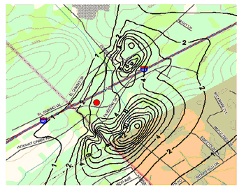
Figure 1: Illustration of a PM hotspot.1
At the first site in Las Vegas, an associated study is being performed by Nevada DOT (NDOT) in conjunction with the FHWA-EPA study. The purpose of the NDOT Study is to measure the ambient MSAT concentrations in several schools adjacent to the US95 highway, focusing on the concentrations of the mobile source air toxic compounds inside three schools while the FHWA-EPA study will look at the concentrations along the road outside the schools.
By performing these near-road studies, a better understanding will be developed for the impact of the mobile source emissions and their influence on communities in close proximity of the highway. As stated above, the goal of conducting these studies is to assess the contribution of vehicles in the near road environment to ambient air toxic compound concentrations. Studies such as the one described in this paper can be used to determine the impacts and develop control strategies for mitigating the consequences vehicle emissions will have on the environment close to roadways. The next section discusses the study design used to understand the dispersion of the vehicle emissions.
The study's goal of characterizing the dispersion and concentrations of the vehicle emitted hazardous air pollutant compounds requires establishing a monitoring network capable of capturing the vehicle emissions and the parameters influencing the vehicle emissions and resulting concentrations. As noted above, several papers have determined that highway emission sources create elevated pollutant concentrations in close proximity to the highway.2 Figure 2 depicts the relationship between the highway and the concentration of the number of particles based on the distance from the highway. This figure, taken from a study by Dr. Yifang Zhu and her colleagues, illustrates a reduction in the number of particles as the receptor (person or monitor) moves away from the highway - a distance defined by about 300 meters (1000 feet) in this study.2 At this distance, the concentrations are considered to return to "normal" urban background levels. Thus, in developing the FHWA-EPA study, measurements of pollutants will be sampled at several locations up to 300 meters (1000 feet) from the roadside. Based on the work of Zhu and others, the hypothesis is that a similar relationship will also exist for other toxic compounds. This 300 meter (1000) zone is based several health studies indicating increased risks within 300 meters (1000 feet) of highways.
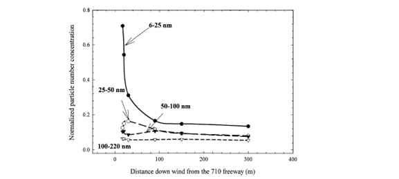
Figure 2: Dispersion of particles near California freeway.2
As part of the initial Phase 1 effort, FHWA developed a peer reviewed measurement plan for collecting the traffic, meteorology and air toxics data. This plan, referred to as the "protocol," recommended the compounds to be measured, the procedures for sampling and analyzing the compounds, the sampling regime and instruments, and procedures for sampling traffic and meteorological data needed to correlate ambient concentrations and vehicle emissions.3 The protocol also defined the monitor site configuration. Figure 3 illustrates the proposed site design for collecting the air pollutant, meteorological, and traffic data. The monitor located about 300 meters (1000 feet) from the highway may represent the "urban background" concentrations, as identified in Zhu's and other studies. Another monitor located further from the study site, perhaps by several miles, may also be used to define or confirm "urban background" concentrations.
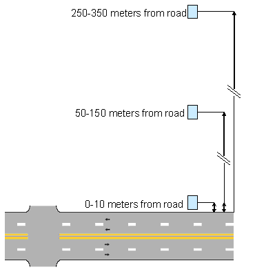
Figure 3: Planned configuration of the MSAT Study monitoring equipment.3
At the roadside defined in Figure 3, the first set of instruments will be located about 10 meters (30 feet) from the highway. Similar sets of instruments will be located at the other distances shown in the figure to define the extent of the dispersion pattern. Also at the roadside location, or in close proximity to this first monitoring station, will be the traffic monitoring station for the site. Plans call for the traffic monitoring equipment to be co-located with the air pollutant monitors to accurately measure the vehicle emissions before they either react or are transported (and therefore diluted) away from the roadway. Traffic monitoring systems are planned to be Intelligent Traffic Systems (ITS) capable of collecting volume of vehicles (the number of vehicles passing a specific location), the speed of the vehicles, and the composition of the vehicle fleet. These traffic parameters are the common variables used to define the traffic conditions needed to determine MSAT impacts. The volume is a common measure of the number of vehicles the highway facility carries at any given location and time and is expressed as the annual average daily traffic (AADT). Generally, sites with AADTs approaching 150, 000 vehicles have been chosen.
Another traffic parameter that is desirable to measure is the average speed of the vehicles since emissions are a function of the vehicle's operating characteristics and measuring this will assist in identifying expected emissions and emission anomalies that may result from traffic incidents and changing operations. Computer modeling for forecasting emissions and their resulting concentrations is linked to traffic volume and speed data and will be used in the analysis of the data. Traffic patterns such as those shown in Figure 4 form the basis of the assumptions used in developing the study.
Finally, vehicle type will be measured to determine the number of light-duty cars and heavy-duty trucks comprising the vehicle fleet passing the monitoring site. In the US, light-duty cars generally burn gasoline while heavy-duty trucks typically burn diesel. Identifying the vehicle types will help assess the difference in contributions between the diesel fleet and gasoline vehicle fleet.
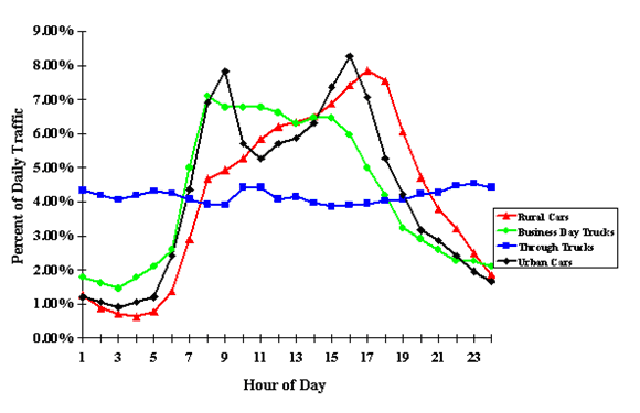
Figure 4: Typical traffic patterns that are the basis for this study.3
As can be seen in the figure, traffic patterns vary throughout the day. Generally in larger cities, two well-defined peaks occur resulting from "rush hour". Traffic measurements at the roadside will help define the vehicle contribution as close as reasonably possible before the dilution of concentration occurs at the greater distances.
Co-located with the traffic monitoring instruments are the air quality monitors for detecting the air toxics compound concentrations. A set of these monitors will also be located at the roadway site at the two other distances from the roadway as shown in Figure 3. Obtaining measurements for the toxic compounds acetaldehyde, acrolein, benzene, 1,3-butadiene, formaldehyde, and DPM at these locations will enable the influence zone or boundary to be defined as in a similar manner as shown in Figure 1.
Since traffic conditions are variable throughout the day, season, and year, a sampling regime was established to define the extremes and average concentrations. This regime is illustrated in Figure 5 and consists of nine samples taken each sampling period.
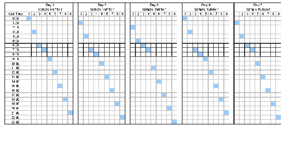
FIGURE 5: Illustration of sampling regime for the samples to be collected at each site.3
A sampling period occurs over one complete day (24 hours) with a frequency of one sample period taken every twelfth day. The result will be about 30 sampling days over the one year test period. Sampling times during each sampling period (24 hour day) are staggered by one hour from one sampling day to the next sampling day to discern any patterns that may occur in the hour not being sampled on any given day. For example, in the first sampling period (Day 1), samples will be taken at 12 mid-night, then 3 am, and so on throughout the day. The second sampling day, twelve days later, will being collection at 1 am, then 4 am, and so on throughout the day. Any pattern that initiates in one of these time intervals can then be observed. The theory is that with this information, beginnings of a pattern such as a rush hour can then be "adjusted" after the data set has been completely sampled. A data set will be completed for each site after one year of data collection.
Rush hours, especially the morning rush hour, was determined to be particularly important and thus two samples are collected within the 6 am to 9 am time interval every sampling day. This additional information will hopefully provide detailed air quality data about this critical period.
The protocol developed for this study requires collecting and analyzing traffic, meteorological and pollutant compounds in accordance with standard sampling methods and using existing instruments and monitoring approaches. These are explained in the FHWA Protocol noted previously but it is useful to discuss some specifics of the test procedures which will be conducted.
As noted earlier, although the primary focus of the study is the analysis of MSAT concentrations, other pollutants will also be measured including carbon monoxide (CO), nitrogen oxide, nitrogen dioxide, black carbon (BC), and PM2.5. Measurements of these compounds are being made to support correlation of the measured MSAT concentrations with these other pollutants, meteorology, and vehicle traffic.
Table 1 discusses the MSAT compounds to be analyzed and the proposed test methods which will be used to determine its concentration. Some issues will be evaluated as the testing is initiated including the minimum detection limits for certain compounds, reactivity of compounds, influence of constantly varying wind direction, and anomalous traffic patterns. Some of the EPA tests selected, such as TO-11A and TO-15 are known to contain some inaccuracies, primarily due to compound stability (reactivity) issues which can result in underestimation of mass. This condition will be evaluated further during the study.
| MSAT | Recommended Monitoring Method in Protocol |
|---|---|
| Acetaldehyde | DNPH cartridges-HPLC analysis (USEPA Method TO-11A) |
| Acrolein | Canister sampling-GC/MS analysis (USEPA Method TO-15) |
| Benzene | Canister sampling-GC/MS analysis (USEPA Method TO-15) |
| 1,3-Butadiene | Canister sampling-GC/MS analysis (USEPA Method TO-15) |
| Diesel particulate matter; | Surrogate monitoring |
| Formaldehyde | DNPH cartridges-HPLC analysis (USEPA Method TO-11A) |
The results of the study will be analyzed to determine the extent to which relationships that exist between emissions from vehicles traveling on a highway can be correlated to the ambient concentration measured along the highway. Traffic related emissions and their resulting concentrations may coincide with the traffic patterns or have another pattern based on influences such as meteorology or topography. Figure 6 illustrates the relationship that will be investigated in this study, the correlation of traffic and concentrations data, as was performed in a previous FHWA study. The previous study, referred to as the "FHWA Supersite Study" 5, attempted to determine whether vehicle traffic and ambient concentrations of certain pollutants, mostly PM2.5, could be correlated. That Study, however, used the air quality monitors established at locations for EPA's national Supersite Study. The EPA Supersite Study was established to determine the contribution from all sources, not just mobile sources and as a result, the monitors were sited to detect "regional", "composite", PM concentrations. Attempts to find correlations with traffic conditions in the FHWA Supersite Study were inconclusive, primarily due to the fact that the monitors were not located in close proximity to highways and due to the significant PM emissions from other sources.
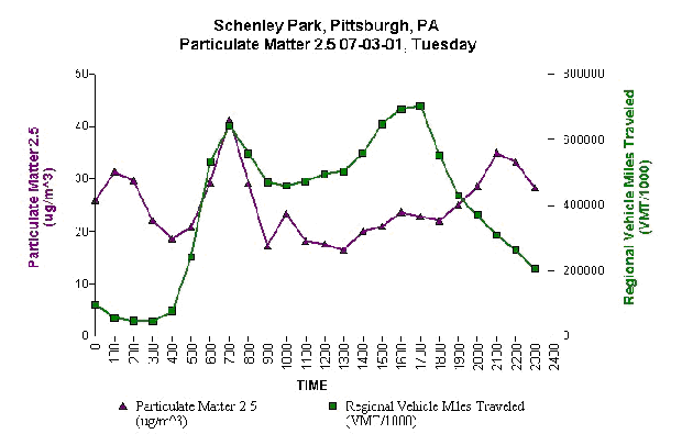
Figure 6: Correlations between traffic PM2.5 data.4,5
In Figure 6 from the FHWA Supersite Study data set, data may show a correlation of emission concentrations of PM2.5 with traffic patterns in the morning rush hour. The traffic data exhibits the standard "double peak" (morning and afternoon) distribution as can also be seen in Figure 4 for urban traffic. The ambient PM2.5 concentrations, however, seem to have no correlation with the afternoon rush hour, likely due to less stable air in the afternoon. Figure 7, also from the Supersite Study data set, illustrates wind conditions at the same site and time as shown in Figure 6 and conveys the increased wind conditions in the afternoon. But it must also be noted that morning inversions are common, which is why you typically see much more elevated concentration peaks in the morning. Thus, it is essential to capture as much data as possible from the parameters most likely to influence the concentrations measured. Wind rose information such as that shown in Figure 8 will be an essential data requirement in this study.
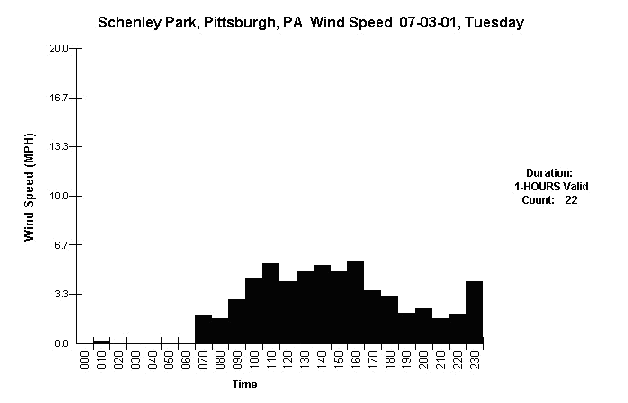
Figure 7: Potential influence of wind on air quality data.4,5
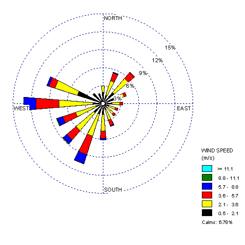
Figure 8: Wind rose data is essential to the study
In addition to the measurements being collected for traffic, meteorological conditions, and air pollutant concentrations, the study will also include computer modeling of the conditions to investigate the accuracy of the models to simulate the monitored conditions. Although not a specific task of the FHWA, study, associated studies of this data may be performed to evaluate exposure and risk to human populations.
As has been stated throughout this paper, the MSAT Study is being initiated to determine the influence highway environments have on ambient concentrations. Although intuition suggests that influences could be significant, factors such as topography, meteorology, and induced transport mechanisms created by moving traffic may lead to variable impacts. Several sites will be studied across the country to provide information on how the emission and dispersion of MSAT compounds in the near-roadway environment may behave. This is important so that mitigation strategies can be developed for reducing the impacts.
Significant efforts were undertaken to design the study so that the information collected would accurately define the impacts. The siting of the instruments and the data collection schedule were established to provide sufficient data for determining the traffic-emission-concentration relationship in an expedient manner. Since data collection can be difficult and costly, the proposed methods that have been included in the protocol are standard procedures to ensure acceptance of the findings. As stated earlier, after review of the initial measurements in Las Vegas, Nevada, FHWA and EPA will work together to assess the effectiveness of the protocol.
Analyzing the results will involve both examination of the traffic, meteorological, and air quality data. The direct measurements of these parameters will yield the conditions at each site. Computer modeling will provide an opportunity to assess the accuracy of the forecasting methods used to predict the impact from highway transportation projects. Differences between the observed data and the modeled data will lead to improved design of forecasting methods.
All of the work performed in this study must be considered relative to the evolution of MSAT regulation. Thus, this study will begin to define the influences of several toxic compounds and lead to a better understanding of the impacts that highways play in the concentrations of MSAT compounds in the near-roadway environment.
mobile source air toxic compounds, MSATs, HAPs, FHWA, EPA, near-road.

