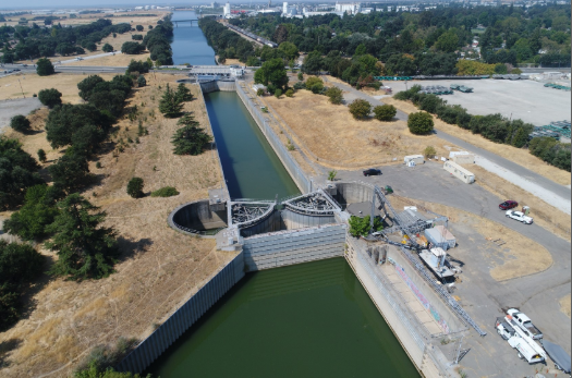
Current normal condition of the Stone Lock Facility. West Sacramento has been investigating flood protection alternatives for the Stone Lock Facility that further support the City’s recreation and environmental objectives for the barge canal
Source: Credit to City of West Sacramento
| Project Name | Pioneer Bluff and Stone Lock Project |
|---|---|
| Location | West Sacramento, CA |
| Project Sponsor / Borrower | City of West Sacramento |
| Program Areas |
|
| Value Capture Techniques | Special Assessment, Tax Increment Financing, & Developer Contribution |
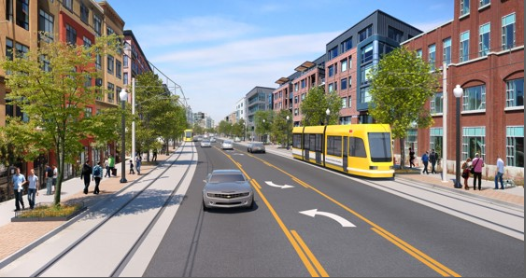
| Mode | Multi-Mode: Bridge, Pedestrian, Bicycle, Light Rail Transit |
| Description | Pioneer Bluff consists of approximately 125 acres of Sacramento riverfront property situated along a one-mile stretch of South River Road. It is part of West Sacramento’s planned urban waterfront and is one of the prime riverfront redevelopment opportunities in the region. Since incorporation in 1987, the City of West Sacramento has articulated its vision for an urban riverfront. In 1990 the City designated Pioneer Bluff for high density mixed-use development in its General Plan. This vision was reiterated in the 2003 Riverfront Master Plan and strengthened in 2004 with a land use policy that prohibits the establishment, expansion, or replacement of non-conforming industrial uses in Pioneer Bluff In 2018, West Sacramento approved a Reuse Master Plan aimed at de-industrializing and redeveloping 325 acres of riverfront property in the Pioneer Bluff and Stone Lock Districts. Considering nearby projects, the plan built off the 2014 Pioneer Bluff Transition Plan’s goal to use the neighborhoods as urban waterfront districts. According to plans, the Pioneer Bluff District will be home to 6,600 new residents and 7,500 new jobs. As part of the project, South River Road south of 15th Street to the Mike McGowan Bridge will be turned into a transit-orientated corridor where automobiles will share the outside lane with a streetcar. The project also may include flood protection alternatives for the Stone Lock Facility to better support recreation and environmental objectives for the barge canal. Plans include a central park concept with:
Additional improvements to Stone Locks Plaza include a trail along the east side of Jefferson Boulevard from Locks Drive to Stone Boulevard, a proposed gateway monument at the intersection of the trail and sidewalk improvements, and a railroad-themed public art installation on the historic lift bridge. A key component of the City’s flood protection system, project completion is projected at 15 years and will stretch across multiple sites in four phases. Once complete, rail corridors in the urban area will be transformed into pedestrian and bicycle paths. |
| Cost | $119,186,960 (estimated Pioneer Bluff transition costs |
| Funding Sources | Federal
State
Local
|
| Project Delivery / Contract Method | Design-bid-build and Public-Private Partnerships |
| Private Partner | N/A |
| Project Advisors / Consultants | DKS Associates |
| Lenders | N/A |
| Duration / Status | N/A |
| Financial Status / Financial Performance | |
| Innovations |
|
| Related Links / Articles |
|
| Contacts | Katy Jacobson Economic Development and Housing Director (916)-617-4535 katyj@cityofwestsacramento.org |