

Manual for Abandoned Underground Mine Inventory and Risk Assessment
Section 2: Initial Informational Review
2.1 GENERAL DISCUSSION:
Three forms of information have been identified as sources to be utilized in initially identifying ODOT Abandoned Underground Mine Inventory and Risk Assessment sites. These three sources of information are: 1) ODOT Field Reports and associated Office Investigations; 2) several forms of ODNR, DGS abandoned underground mine documents, and; 3) reports of subsidence activity adjacent to the roadway documented by other state and federal agencies.
2.2 FIELD REPORT FORMS:
Distribution and completion of field report forms to district employees should be undertaken. The information gathered through the use of these forms may document actual physical changes in or under the roadway which may be related to mapped or unmapped abandoned underground mines. These Field Reports are very important for they may, in some cases, be the only documentation of sites which will be placed in the highest priority, Detailed Site Evaluation Surface Deformation Site Group. All field reports shall be assigned a number upon receipt. A sample copy of this form is provided as Figure 2.1
All Field Reports should be investigated and documented through the use of the Office Investigations of Field Report form. This form should be assigned the same number as the Field Report being investigated. A sample copy of this form is provided as Figure 2.2
2.3 ODNR, DGS ABANDONED UNDERGROUND MINE DOCUMENTS:
Each District should acquire and review copies of the Abandoned Underground Mine Map Series maps ( U.S.G.S.Quadrangle based) available at the Ohio Department of Natural Resources, Division of Geological Survey (DGS). A sample copy of a portion of one of these maps is provided as Figure 2.3. Working copies of these maps should be made and marked with a" hi-liter" to indicate roadway locations potentially underlain by abandoned underground mines for which the DGS has available mapping. The District may also acquire county maps from DGS which are composite maps of the individual abandoned Underground Mine Map Series maps at a scale of 1" = 1 mile.
Ohio Department of Transportation
As a part of establishing a listing of sites to be evaluated by the abandoned underground mine inventory, the District is gathering information regarding past or present maintenance or construction problems which may have been, or are, related to the presence of mines beneath the roadway. Please report any unusual grade settlements or drainage conditions which you observed or upon which you have performed work either during maintenance or construction operations with the District. Please report any information, even if the condition/problem and related construction or maintenance occurred years ago. All known conditions/problems within the right of way should be reported. Significant conditions immediately beyond the right of way may also be indicators of conditions evolving beneath the roadway.
Please return this completed form to____________ at the District ____________ Office. If you have any questions about the completion of this form, or wish to discuss information you are reporting on this form, please contact (District Contact Person) at (Telephone number). For District Office Use: Field Report No.__________ | |||||||
| Ohio Department of Transportation Abandoned Underground Mine Inventory and Risk Assessment Office Investigation of Field Report |
Action Required: 1) 2) 3) |
|---|---|
|
Person Filing Original Field Report:__________________________Field Report No.__________ Note to Investigator: Please contact the person providing the field report and make a record of the conditions which were observed or upon which work was performed either during maintenance or construction operations within the District. Use a new copy of this form for each separate roadway location. Be sure to make a record of any information, even if the condition/problem and related construction /maintenance occurred years ago. All known conditions/problems within the right of way should be reported. Significant conditions immediately beyond the right of way may also be indicators of conditions evolving beneath the roadway. Location of Condition/Problem (C-R-S)______________________________________________ Check Appropriate Box(es): Surface Grade Problems:
Drainage Problems/Irregularities (Check all appropriate items): Are these drainage conditions seasonal or year-round:__________________________________ General Information: Is the person who completed the field report aware of any underground mines reported to exist in the vicinity of the roadway area? If so, please provide the name of the mine(s) here:___________ Names of other contact person(s) (ODOT or private sector) which may be able to provide Other information which may be pertinent:____________________________________________ PLEASE ATTACH A MAP OR SITE SKETCH OF THE FIELD REPORT AREA | |
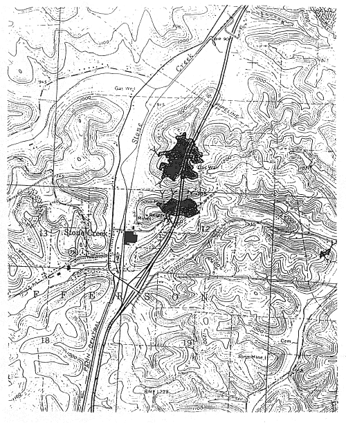
Figure 2.3: Sample Portion of ODNR, DGS Abandoned Underground Mine Map Series
ODNR, DGS has designated a contact person for members of the ODOT Abandoned Underground Mine Inventory and Risk Assessment technical team (See Appendix D: Contacts). The DGS has provided the following information regarding the Abandoned Underground Mine Map Series maps available from its office:
A.) These maps represent the locations of as many of the 4600 available Division of Mines abandonment maps as could be accurately located by DGS. Some small percentage of the available abandonment maps are not shown on the Abandoned Underground Mine Map Series maps because they do not contain enough information to be accurately located.
B.) The DGS has recently acquired annual underground mine maps originally filed with the former Division of Mines between 1874 and 1995. Some of these maps may represent underground mines for which there are no abandonment maps on record. Others may contain information as to the extent of some mines which the corresponding abandonment maps do not contain. The DGS estimates there are between 5,000 and 10,000 of these maps. The DGS still needs to review these maps and add any new information they contain to the currently available Abandoned Underground Mine Map Series maps.
C.) Other potential sources of abandoned underground mine maps include the Recorders Office at each county courthouse and the U.S. Dept. of Interior, Office of Surface Mining (OSM), Appalachian Regional Center's underground mine map repository located in Pittsburgh, Pennsylvania. An OSM comparison of their mine map collection versus the ODNR, DGS map collection suggested the possibility of up to 845 mine maps in the OSM collection which are not in the ODNR, DGS collection. DGS and OSM are currently working to resolve this situation so that both agencies will each have the same comprehensive collection of maps available.
A cooperative effort is currently underway by ODNR and ODOT to develop a plan to digitally scan all available abandoned underground mine maps, and develop a mutually accessible GIS database for these maps and associated attribute file information. ODNR is already digitizing the Abandoned Underground Mine Map Series maps.
Each district should acquire and review the appropriate Abandoned Underground Mine Map Series maps and related county composite maps for their District. Each shaded area on these maps represents an individual abandoned underground mine map which can be obtained from the ODNR, DGS. This will give each District an indication of the number and distribution of abandoned underground mines within its geographic area.
The following guidelines should be reviewed before the use of these maps to compile the initial inventory site listing:
A) Become VERY FAMILIAR with the symbols in the legend of the Abandoned Underground Mine Map Series maps.
B) The accuracy for any given mine location indicated on these maps is not always high. The ODNR, DGS took painstaking efforts to accurately locate the mines as displayed on these maps. However, the accuracy, quantity, and quality of the information contained on the original abandonment maps filed by the miner or mining company can be highly variable. Past ODOT work with these maps has revealed the actual mine locations to be up to one-half township section away from the locations as shown on the Abandoned Underground Mine Map Series maps.
C) The Abandoned Underground Mine Map Series maps may not show a mine beneath the roadway. But a mine map location adjacent to the roadway may be shown with cross-hatching in the direction of the roadway. The cross-hatching indicates that the map has notations of adjacent underground mining. These mine maps should be acquired as they represent the best and nearest documentation of past underground mining activities in the vicinity of the roadway. The cross-hatching on the margins of these maps indicates the possibility of unmapped mines in the vicinity of the roadway. This fact should be considered in determining sites for the initial site inventory. Unmapped mines may be present even if cross-hatching is not indicated.
2.4 OTHER OUTSIDE AGENCY REPORTS OF SUBSIDENCE ACTIVITY:
Each District shall obtain and review any available information from other state and federal agencies which document mine subsidence events in close proximity to roadways under the State's jurisdiction. These state and federal agencies include: 1) the ODNR, DMR, Abandoned Mine Lands Program; 2) the U.S.D.I., Office of Surface Mining Regulation and Enforcement, Ohio Field Office, and: 3) the Ohio Mine Subsidence Insurance Program. Refer to Appendix D: Contacts for further information.
This information may be critical in evaluating inventory sites. It may represent the only documentation of unmapped, abandoned underground mines which lie beneath the roadway.
The coordinating District engineer should notify the ODNR, DMR when a field report indicates a potential subsidence problem, especially those events which ODOT would eliminate because the event does not threaten the traveling public.
2.5 INITIAL INVENTORY SITE LISTING:
Each District should compile an initial inventory site listing utilizing the three above-described sources of information. The first step toward establishing this initial site listing should be to compile a listing of the roadway sites "hi-lighted" on the working set of the Abandoned Underground Mine Map Series quadrangle maps. This compiled listing should be in the form of a Quattro Pro spreadsheet file. An example of this spread sheet is provided as Figure 2.4. The spreadsheet should have columns for : county; route; section; site length; lane miles; site evaluation status; risk assessment rating (site group and site evaluation rating); ODNR, DGS mine map index number; U.S.G.S. quadrangle name; GPS coordinates; state plane coordinates; site elevation; township and section; and comments (mine name, field report number, etc.). The electronic spreadsheet file for this document is available from the Office of Materials Management, Geotechnical Design Section. The use of this one spreadsheet by all districts is crucial to creating the ability of the Department to compile and analyze statewide information regarding the problem of abandoned underground mines beneath state roadways.
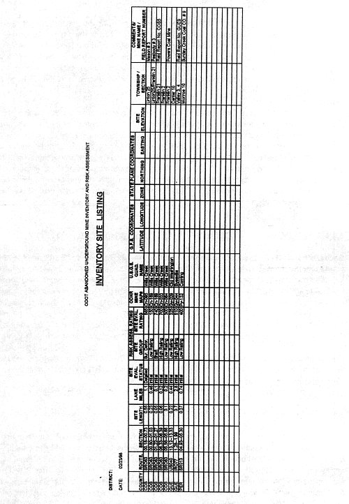
Figure 2.4: Example of Inventory Site Listing |
Field reports, subsidence event reports, and research reports from other State and Federal government agencies should be compared to the above listing. These reports should be recorded for the related site listed on the established spreadsheet, or otherwise should be entered as additional sites on the initial inventory site listing.
| <<Previous | TOC | Next>> |