

Archived: Interstate Technical Group on Abandoned Underground Mines
An Interactive Forum
A Generalized Protocol for Selecting Appropriate Geophysical Techniques
Neil Anderson (nanders@umr.edu) and Ahmed Ismail (aib57@umr.edu)
Department of Geology and Geophysics
University of Missouri-Rolla,
Rolla, Missouri 65401
Abstract
Geophysical tools provide information about the physical properties of the subsurface, and are routinely applied to mining-related problems of a geotechnical nature. Geophysical data, if properly acquired, processed, constrained and interpreted, can be transformed into site models (typically subsurface geologic models). These site models can be of great practical utility inasmuch as they provide subsurface control in inter-boreholes areas and at sub-borehole depths.
The mining engineer responsible for geotechnical site characterization should ensure all geophysical techniques employed are capable of providing useful and cost-effective information about the subsurface feature(s) of interest at the required levels of spatial resolution and target definition. As an aid to the geotechnical engineer, tabularized information about ten commonly employed geophysical methods and a generalized approach (protocol) for evaluating their utility as site characterization tools are presented herein. The accompanying discussions are intended to be informative - not exhaustive. The reader is referred to the selected bibliography for more rigorous treatments of the geophysical techniques. The engineer engaged in geophysical survey design is strongly encouraged to work with a knowledgeable geophysicist.
Introduction
Geophysical tools (Table 1) are routinely used to image the subsurface of the earth in support of mining-related geotechnical investigations, including the detection and mapping of abandoned underground coal mines. Commonly employed geophysical methods include seismic refraction, seismic reflection, seismic tomography, ground-penetrating radar (GPR), electromagnetics (EM), electrical resistivity, induced polarization (IP), magnetics, self potential (SP) and gravity (Table 1; Figures 1 and 2).
Geophysical tools are designed to measure specific parameters, and are generally used to measure spatial variation in these specific parameters within a study area of interest (Table 1). Ground-penetrating radar (GPR) instruments, for example, are designed to measure the two-way travel times and amplitudes of reflected pulsed electromagnetic radiation (Figure 1 and Table 1). During the course of a typical GPR survey, these tools are used to measure spatial variations in the travel times and amplitudes of EM radiation that has been reflected from subsurface horizons (or features) of interest. The example 2D GPR profile presented as Figure 3a consists of multiple adjacent traces (reflection amplitude plotted as a function of two-way travel time) which were acquired at predetermined intervals along a 2-D traverse across a shallow stream. The GPR profile contains only one prominent reflection and hence is considered to be two-layered (water overlying sand).
The specific parameters measured by geophysical tools (Table 1) are functions of the physical properties of the earth's subsurface. For example, the travel times and amplitudes of the reflected pulsed electromagnetic radiation recorded during a GPR survey, are functions of the variable electrical and magnetic properties of the subsurface (including dielectric constant, magnetic permeability, conductivity and EM velocity) along the respective raypaths (Figure 1). The dielectric constants and EM velocities assigned to each of the two layers identified on the GPR profile of Figure 3 were determined/estimated on the basis of in-situ GPR field tests. The arrival time of the reflected event (water/sand interface) at any trace location on the GPR profile (Figure 3a) is a function of the EM velocity of water; the amplitude of the GPR event at any trace location is a function of the contrasting dielectric constants of water and sand.
| Geophysical Method | Measured Parameter(s) | Physical Property or Properties | Physical Property Model (Geotech Application) | Typical Site Model (Geotech Application) |
|---|---|---|---|---|
| Shallow Seismic Refraction | Travel times of refracted seismic energy (p- or s-wave). | Acoustic velocity (function of elastic moduli and density). | Acoustic velocity/depth model. | Geologic profile. |
| Shallow Seismic Reflection | Travel times and amplitudes of reflected seismic energy (p-or s-wave). | Density and acoustic velocity (acoustic velocity is a function of elastic moduli and density) | Acoustic velocity/depth model. | Geologic profile. |
| Seismic Tomography | Travel times and amplitudes of seismic energy (p- or s-wave). | Density and acoustic velocity (acoustic velocity is a function of elastic moduli and density). | Model depicting spatial variations in acoustic velocity. | Geologic profile. |
| Ground-Penetrating Radar(GPR) | Travel times and amplitudes of reflected pulsed electromagnetic energy. | Dielectric constant,magnetic permeability, conductivity and EM velocity. | EM velocity/depth model. | Geologic, material or structure profile. |
| Electro-magnetics (EM) | Response to natural/induced electromagnetic energy. | Electrical conductivity and inductance. | Conductivity/depth model. | Geologic/hydrologic profile. |
| Electrical Resistivity | Potential differences in response to induced current. | Electrical resistivity. | Resistivity/depth model. | Geologic/hydrologic profile. |
| Induced Polarization(IP) | Polarization voltages or frequency dependent ground resistance. | Electrical capacitance. | Capacitance/depth model. | Model depicting spatial variations in clay content (or metallic mineralization). |
| Self Potential(SP) | Natural electrical potential differences. | Natural electric potentials. | Model depicting spatial variations in natural electric potential of the subsurface. | Hydrologic model(seepage through dam or fractured bedrock,etc.). |
| Magnetics | Spatial variations in the strength of the geomagnetic field. | Magnetic susceptibility and remanent magnetization. | Model depicting spatial variations in magnetic susceptibility of subsurface. | Geologic profile or map (location of faults, variable depth to bedrock, etc.). |
| Gravity | Spatial variations in the strength of gravitational field of the earth. | Bulk density. | Model depicting spatial variations in the density of the subsurface. | Geologic profile or map (location of voids, variable depth to bedrock, etc.). |
Table 1: Summary of ten geophysical surveying methods commonly employed for geotechnical investigations.
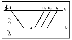 |
Seismic Refraction: Typically, acoustic pulses are generated at predetermined source locations (S) along the length of the refraction seismic profile. The travel times of acoustic energy that has been critically refracted at horizons of interest (L1) is recorded at predetermined receiver locations (R). The recorded travel time information is used to generate a velocity/structure profile of the shallow subsurface along the length of the refraction profile. |
 |
Seismic Reflection: Typically, acoustic pulses are generated at predetermined source locations (S) along the length of the reflection seismic profile. The travel times and amplitudes of reflected acoustic energy is recorded at predetermined receiver locations (R). The recorded travel time/amplitude information is used to generate a reflection seismic profile. These data can be transformed into a velocity/structure profile. |
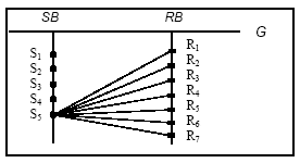 |
Seismic Tomography: Typically, high frequency acoustic pulses are generated at predetermined source locations (S) in the source borehole (SB). The amplitude and arrival time of direct arrivals (and others) is recorded at predetermined receiver locations in the receiver borehole (RB). The recorded travel time/amplitude data are statistically analyzed and used to generate a velocity/ attenuation cross-sectional model of the area between the source and receiver boreholes. |
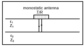 |
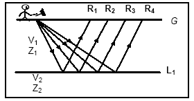
Ground-Penetrating Radar (GPR): Typically, pulsed electromagnetic energy is generated at predetermined station locations (S) along the length of the GPR profile. The travel times and amplitudes of reflected EM energy are usually recorded by a monostatic transmitter/receiver. The recorded travel time/amplitude information is normally used to generate a GPR profile (2-D time/amplitude image). These data can be transformed into a 2-D velocity/depth model. |
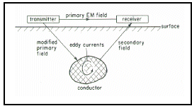 |
Electromagnetics (EM): Typically, a receiver is used to measure the earth's response to natural or artificial, primary EM energy. The secondary EM field (generated by causative body) can be expressed in terms of an in-phase component and an out-of-phase component. These data can be interpreted, and in some instances, used to generate a conductivity/depth model of the subsurface. |
Figure 1: Generalized overviews of five commonly employed geophysical tools: seismic refraction, seismic reflection, seismic tomography, ground-penetrating radar (GPR) and electromagnetics (EM).
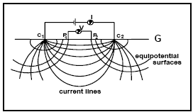 |
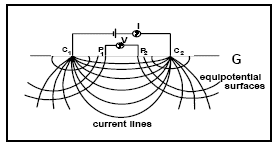
Electrical Resistivity: Typically, current (I) is induced between paired electrodes (C1, C2). The potential difference (ΔV) between paired voltmeter electrodes P1 and P2 is measured. Apparent resistivity (ρa) is then calculated (based on I, ΔV, electrode spacings). If the current electrode spacing is expanded about a central location, a resistivity/depth sounding can be generated. If the array is expanded and moved along the surface, a resistivity/depth profile can be created. |
 |
Induced Polarization (IP): Two types of IP data are generated: frequency domain and time domain. Frequency domain IP data are generated by comparing apparent resistivities as determined for variable frequency input currents. Time domain IP data are generated by measuring rate of decay in potential difference after current flow is terminated. IP measures the capacitive properties of the ground. Often acquired simultaneously with resistivity data. |
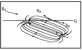 |
Magnetic: Magnetometers are designed to measure either the vector or scalar sum of the earth's magnetic field (BE) and superposed secondary magnetic fields (BS) created by causative, magnetically susceptible materials. Generally, the secondary field is isolated and interpreted with a view to elucidating the nature of the secondary causative body. |
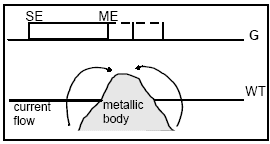 |
Self Potential (SP): Self (spontaneous) potential tools are designed to measure natural potential differences arising (mostly) from either current flow associated with metallic bodies straddling the water table or ground water flow in the subsurface. SP data are usually interpreted in qualitative manner. |
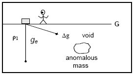 |
Gravity: Gravimeters are designed to measure the vertical component of the vector sum of the earth's background gravitational field (gE) and superposed secondary fields (Δg) created by localized, causative bodies of anomalous density. Generally, the secondary field is isolated and interpreted with a view to elucidating the nature of the secondary causative body |
Figure 2: Generalized overview of five commonly employed geophysical tools: electrical resistivity, induced polarization (IP), magnetics, self potential (SP) and gravity.
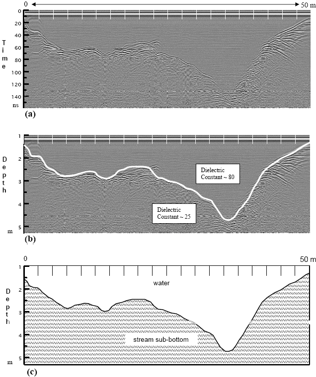
Figure 3: (a) GPR profile across a stream bed; (b) Physical Property Model (dielectric constant vs. depth); (c) Typical Site Model.
Properly acquired and processed geophysical survey data can generally be transformed into a physical property model. GPR data, for example, are frequently transformed into corresponding 2-D or 3-D "dielectric constant/depth" model. The typical GPR physical property model of Figure 3b consists of one reflecting horizon (water/sand interface). In this "dielectric constant/depth" model, the vertical "time-depth" scale has been transformed into a vertical "depth" scale (time-to-depth conversion). Alternative physical property models could be in the form of "EM velocity/depth", "EM velocity/time-depth", etc.
If additional geophysical and/or geological (including hydrologic, engineering, mining) constraints are available, physical property models can be transformed into "typical site models". A typical site model for mining-related investigations is a geologic model. In Figure 3c, the GPR physical property model of Figure 3b, has been transformed into a simple hydrologic/geologic model on the basis of site geomorphology and subsurface lithologic control.
Geophysics in Support of Geotechnical Site Characterization
In the normal course of a geotechnical site investigation, one or more geophysical data sets may be acquired for the purpose of determining subsurface physical properties of interest (Table 1). Typically, non-geophysical information (borehole, geohydrologic, surficial geology, mining records, construction records, etc.) is also acquired, all contributing to the interpretation of the geophysical data and the development of a typical site model.
To ensure the most appropriate geophysical techniques are employed, the supervising engineer (working with a knowledgeable geophysicist) should critically evaluate the potential utility and cost-effectiveness of available geophysical methods. There are several key "issues/questions" that should be considered/ addressed including:
- What are the physical properties of interest?
- Which geophysical methods respond to the physical properties of interest?
- Which techniques can provide the required spatial resolution and target definition?
- Which geophysical tools can perform well under study area conditions?
- Which techniques are most cost-effective?
- Which techniques can provide complementary data?
- What non-geophysical control is required to constrain the interpretation of acquired geophysical data?
- Is the overall geophysical program cost-effective?
If these issues are not addressed, inappropriate geophysical data may be acquired, unnecessary expenditures may be incurred, and undesirable time delays may occur. In the worst case scenario, the acquired geophysical data - even when constrained and interpreted - may not be capable of providing the required/desired results (re: typical site model). The engineer responsible for geophysical site characterization is encouraged to raise and resolve these issues prior to the commencement of field work.
Protocol for Selecting Appropriate Geophysical Techniques
The eight "issues/questions" posed in the preceding section constitute a generalized protocol for selecting appropriate geophysical techniques. In the following section, these "questions/ issues" are briefly discussed, using a hypothetical case study situation to illustrate some of the ideas presented. These discussions are intentionally general in nature (and illustrative) rather than comprehensive. The intent is to raise, summarize and illustrate some pertinent issues in an effort to assist the supervising engineer.
What are the physical properties of interest? Geophysical surveys are usually conducted with specific objectives (subsurface targets) in mind. These targets and their physical properties need to be clearly defined from the outset, to ensure appropriate geophysical methodologies are employed.
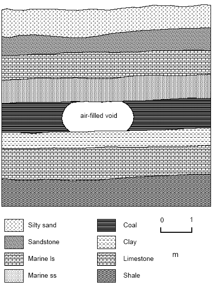
To illustrate the interrelationship between subsurface targets, their physical properties and appropriate geophysical technologies, consider a hypothetical situation where a mining engineer intends to investigate a proposed construction site (300 m x 300 m) with the objective of mapping any and all shallow air-filled voids (associated with previous coal mining activities). For the purpose of illustration, assume the voids can be modeled as oblate spheroids (height of ~1 m and width of ~3 m) with extended north-south oriented near-horizontal axis, centered at depths on the order of 3.5 m (Figure 4). Assume there are no physical constraints with respect to site accessibility, and that the subsurface geology is as depicted in Figure 4. For the sake of simplicity, assume the voids are intact and devoid of metal objects. Lastly, assume surface control at intervals on the order of 2 m is required.
The engineer responsible for the acquisition of geophysical data in support of this hypothetical site characterization would recognize that shallow, air-filled cavities within otherwise intact sedimentary rock are characterized by spatial variations in density, acoustic velocity, EM velocity, dielectric constant, electrical conductivity and electrical resistivity (Figure 4). Collectively, these variable attributes represent the physical properties of interest (Table 1).
| Physical Property | Non-Saturated Sedimentary Rock | Air-Filled Void |
|---|---|---|
| Density | ~ 2.4 g/cc | 0 |
| Acoustic velocity | ~ 4000 m/s | ~ 350 m/s |
| EM velocity | 108m/s | 3 x 10⁸m/s |
| Dielectric constant | ~ 9 | ~ 1 |
| Electric conductivity | 10-8mho | 0 |
| Electric resistivity | 3 X 10⁷Ωm | ~ infinite |
| Magnetic susceptibility | 0.3 | ~ 0 |
| Electric chargeability | 10 - 20 ms | ~ 0 |
Figure 4: (a) Schematic west-east geologic profile through hypothetical study area; (b) Physical property table for non-saturated rock and void.
Which geophysical methods respond to the physical properties of interest? The engineer charged with site characterization responsibilities, working in consultation with a knowledgeable geophysicist, would consider all available geophysical technologies with a view to determining which tools are designed to respond to one or more of these physical properties of interest.
As far as the hypothetical case study is concerned, several geophysical techniques would appear to be potentially suitable site investigation tools (based on the limited information provided in Table 1 only) including seismic refraction, seismic reflection, seismic tomography, GPR, EM, electrical resistivity and gravity. (Note: the supervising engineer is strongly encouraged to work with a knowledgeable geophysicist to ensure all potentially appropriate geophysical technologies are considered.)
The seismic refraction, seismic reflection and seismic tomography techniques respond to subsurface variations in acoustic velocity and density (either directly or indirectly). The GPR tool responds to spatial variations in dielectric constant, magnetic permeability, electrical conductivity and EM velocity. The EM tools respond to changes in electrical conductivity and inductance; the electrical resistivity tools respond to changes in electrical resistivity. The gravity tool is designed to respond to spatial variations in the density of the subsurface.
Each of the seven geophysical techniques still in consideration measures specific physical parameters (Table 1; Figures 1 and 2). These measured parameters are functions of the physical properties of the subsurface (and variations therein). The seismic refraction, reflection and tomography techniques, for example, measure the amplitudes and travel times of acoustic energy. The GPR tool measures the amplitudes and arrival times of pulsed EM energy. The EM and electrical resistivity tools measure the earth's response to natural/induced electromagnetic energy, and potential differences in response to induced current, respectively. The gravity tool measures spatial variations in the strength of gravitational field of the earth.
Which techniques can provide the required spatial resolution and target definition? Each of the seven geophysical techniques still in consideration is typically used to measure spatial variations in specific parameters within a designated study area. Each of these tools provides varying degrees of spatial resolution (vertical and horizontal) and target definition (shape, depth, etc.).
In Table 2, short qualitative discussions of spatial resolution and target definition are presented for each of the ten techniques listed in Table 1. All of these geophysical techniques, with the notable exception of seismic tomography, provide greater spatial resolution and target definition at shallower depths. A high-frequency GPR tool (e.g., 1.5 GHz) for example, can provide very high spatial resolution (on the order of 0.01 m) but has limited depth penetration (generally less than 1m). A low-frequency GPR tool (e.g., 80 MHz) provides only intermediate spatial resolution (on the order of meters), but is capable of imaging targets at depths on the order of 20 m or more under ideal circumstances.
As noted in Table 2, the spatial resolution and target definition provided by each geophysical technique are functions of multiple variables including (but not limited to) the contrast between the physical properties of the target and host rock, the depth of the target, background noise levels, the attributes of the specific tool employed, etc. These variables must be considered during this phase of pre-planning.
With respect to the hypothetical case study and based on spatial resolution/target definition considerations provided in Table 2 only, GPR, electrical resistivity, gravity and seismic tomography appear to be potentially suitable tools for locating the relatively small, shallow air-filled cavities of interest. Seismic refraction and seismic reflection are probably not capable of directly imaging small, air-filled voids at shallow depth (<4 m). The electromagnetic tool works best when the target is conductive, and may not be capable of resolving an air-filled void in fairly resistive sedimentary rock.
Consultation with an expert is essential during the spatial resolution and target definition phase of tool selection as only a knowledgeable geophysicist will be able to determine (on the basis of experience and/or modeling) which specific geophysical tools are theoretically capable of providing the required spatial resolution and target definition (given target properties, depth, shape and size).
| Method | Spatial Resolution and Target Definition |
|---|---|
| Shallow Seismic Refraction | Intermediate. Spatial resolution and target definition are functions mostly of source frequency, propagation velocities, velocity contrasts, layer thickness and homogeneity, receiver spacing, background noise levels and site conditions. The shallow refraction tool is generally used to map horizons across which there is a significant positive velocity contrast (e.g., bedrock, water table, etc.). The refraction tool cannot be used to map low-velocity layers or thin high-velocity layers. Low-frequency sources provide greater depth penetration but lower resolution. |
| Shallow Seismic Reflection | Intermediate. Spatial resolution and target definition are functions mostly of source frequency, propagation velocities, velocity and density contrasts, layer thickness and homogeneity, receiver spacing, background noise levels and site conditions. The shallow reflection tool can be used to map both low- and high-velocity layers. It is generally assumed that layers with thicknesses of less than ¼ wavelength (function of seismic pulse frequency and layer velocity) cannot be accurately resolved. Subsurface discontinuities (such as an air-filled void) can generate identifiable, interpretable diffractions. Low-frequency sources provide for greater depth penetration but lower resolution. |
| Seismic Tomography | Intermediate - High. Spatial resolution and target definition are functions mostly of source frequency, propagation velocities, velocity and density contrasts, layer/unit homogeneity, source/receiver spacing, multiplicity of travel paths, background noise levels and other site conditions. Seismic tomography employs very high-frequency acoustic source pulses (in KHz range) compared to seismic refraction and reflection and therefore provides superior resolution and target definition. |
| GPR | Intermediate - Very High. Spatial resolution and target definition are functions mostly of dominant EM source pulse frequency, propagation velocities, dielectric contrasts, layer thickness and homogeneity, lateral trace sampling density, background noise levels and site conditions. GPR employs high-frequency (in MHz range) pulsed EM radiation traveling at velocities approaching the speed of light. High-frequency (1500 MHz) antenna can effectively image layers with a thickness on the order of centimeters. Low-frequency sources provide for greater depth penetration but lower vertical and lateral resolution. |
Table 2a: The spatial resolution and target definition provided by a geophysical technique is a function of the characteristics of the specific tool employed, site conditions, and the physical properties of the target.
Which geophysical tools can perform well under study area conditions? The usefulness of a specific geophysical tool is a function of site conditions. Variables include (but are not limited to) accessibility, areal extent, density of vegetation, topography, soil thickness and lithology, groundwave salinity, etc. Site conditions must be taken into consideration during the pre-planning phase, to ensure the technique(s) selected have a reasonable probability of working well in the study area. Consultation with an expert geophysicist is strongly encouraged.
In terms of the hypothetical site conditions, the intended targets are small, linear, oblate (1 m x 3 m), mined-out, linear, air-filled voids centered at depths on the order of 3.5 m in sedimentary rock overlain by about 1 m of unconsolidated sandy silt (devoid of clay). As noted in Figure 4, the ground and bedrock surfaces are characterized by undulating topography.
With respect the hypothetical case study and on the basis of the site considerations (as provided in Table 3 only) and spatial resolution and target definition (as provided in Table 2 only), GPR would probably be ranked highest in terms of potential utility (Table 4). The GPR tool should provide the necessary spatial resolution and target definition, as the air-filled voids are relatively shallow. Additionally, the voids and the encompassing rock are characterized by markedly different EM velocities (Table 2). Lastly, the sedimentary section is relatively dry and devoid of clay. If quality GPR data were recorded along profiles oriented perpendicular to the linear voids, the interpreter might be able to map the subsurface location of voids with a spatial precision of less than one meter.
The resistivity tool is similarly capable of imaging the air-filled subsurface voids. This technique is ranked ndin Table 4 (in terms of utility based on spatial resolution, target definition and site conditions). If the resistivity profiles are oriented perpendicular to the strike of the linear voids, the tool is theoretically capable of imaging the intended target. However, the spatial resolution provided by the electrical resistivity tool would probably be less than that provided by GPR.
A high precision gravity tool is theoretically capable of imaging the air-filled linear voids, given their shallow depth and cross-sectional area. However, undulating surficial topography and variable depth to bedrock could create problems due to the subtle signature associated with the target. Even with high density sampling and precise reduction, the spatial resolution provided by a high precision gravity tool would probably be less than that provided by either the GPR or resistivity tools.
The seismic tomography tool is also theoretically capable of imaging the target voids. However, this technique is considered to be the least viable because the small size of the target would require the generation/recording of very high frequency source signals, and the drilling of very closely spaced test boreholes through sedimentary rock.
| Method | Spatial Resolution and Target Definition |
|---|---|
| EM | Low - Very High. Spatial resolution and target definition are functions mostly of primary source frequency, target depth and conductivity, conductivity contrast, and sophistication of tool and inversion software. For example, a 5 cm diameter, 2m long, conductive metal pipe at shallow depth (< 0.5 m) in dry soil can be readily located using a suitable high-frequency EM tool. However the metal pipe, placed at a depth of 3 m, might be "invisible" to the same EM tool. Lower frequencies provide for greater depth penetration but poorer resolution and target definition. Technique works best when imaging conductive targets. Data acquired over a range of frequencies can be inverted and used to generate a conductivity profile of the subsurface. Some tools provide data suitable for qualitative analyses only. |
| Electrical Resistivity | Low - High. Spatial resolution and target definition are functions mostly of primary current frequency, current and voltmeter electrode spacing, target depth and resistivity, resistivity contrast, and sophistication of tool and inversion software. Technique works best in resistive environments and when imaging resistive targets. Lower frequency current and increased electrode spacing provide for greater depth penetration but poorer resolution and target definition. Apparent resistivity data acquired over a range of electrode spacings can be inverted and used to generate a conductivity profile of the subsurface. Some tools/electrode configurations provide data suitable for qualitative analyses only. |
| IP | Low - Intermediate. Spatial resolution and target definition are functions mostly of electrode spacing, target depth and resistivity, susceptibility of target to induced polarization, resistivity contrast, and magnitude of background noise. Tool works best in resistive environments and when imaging targets susceptible to induced polarization. Increased electrode spacing and lower current frequencies provide for greater depth penetration but poorer resolution and target definition. Data are often acquired during course of resistivity surveying. |
| SP | Low - Intermediate. Spatial resolution and target definition are functions mostly of voltmeter electrode spacing, target size and depth, magnitude of naturally occurring potential differences, and magnitude of background noise. Data generally suitable for qualitative analyses only. |
| Magnetics | Low - High. Spatial resolution and target definition are functions mostly of sophistication of tool and mode of deployment, spatial sampling intervals, magnitude of background noise, target depth and magnetic susceptibility, magnetic susceptibility contrasts, and external modeling constraints. Data are often interpreted qualitatively. |
| Gravity | Low - Intermediate. Spatial resolution and target definition are functions mostly of sophistication of tool and inversion software, spatial sampling interval, magnitude of background noise, target depth, density contrasts and external modeling constraints. Data are often interpreted quantitatively. |
Table 2b: The spatial resolution and target definition provided by a geophysical technique is a function of the characteristics of the specific tool employed, site conditions, and the physical properties of the target.
Which geophysical tools can perform well under study area conditions? The usefulness of a specific geophysical tool is a function of site conditions. Variables include (but are not limited to) accessibility, areal extent, density of vegetation, surficial topography, soil thickness and lithology, groundwave salinity, level of background noise, etc. Site conditions must be taken into consideration during the pre-planning phase, to ensure the technique(s) selected have a reasonable probability of working well in the study area. Consultation with an expert is strongly encouraged.
In terms of the hypothetical site conditions, the targets are small, linear, oblate (1 m x 3 m), mined-out, linear, air-filled voids centered at depths on the order of 3.5 m in sedimentary rock overlain by about 1 m of unconsolidated sandy silt (devoid of clay). As noted in Figure 4, the ground and bedrock surfaces are characterized by undulating topography.
With respect the hypothetical case study and on the basis of the site considerations (as provided in Table 3 only) and spatial resolution and target definition (as provided in Table 2 only), GPR would probably be ranked highest in terms of potential utility (Table 4). The GPR tool should provide the necessary spatial resolution and target definition, as the air-filled voids are relatively shallow. Additionally, the voids and the encompassing rock are characterized by markedly different EM velocities (Table 2). Lastly, the sedimentary section is relatively dry and devoid of clay. If quality GPR data were recorded along profiles oriented perpendicular to the linear voids, the interpreter might be able to map the subsurface location of voids with a spatial precision of less than one meter.
The electrical resistivity tool is similarly capable of imaging the air-filled subsurface voids. This technique is ranked 2ndin Table 4 (in terms of utility based on spatial resolution, target definition and site conditions). If the 2-D resistivity profiles were oriented perpendicular to the strike of the linear voids, the tool is theoretically capable of imaging the intended target. However, the spatial resolution provided by the electrical resistivity tool would probably be less than that provided by GPR.
A high precision gravity tool is theoretically capable of imaging the air-filled linear voids, given their shallow depth and cross-sectional area. However, undulating surficial topography and variable depth to bedrock could create problems due to the subtle gravity signature associated with the target. Even with high density sampling and precise reduction, the spatial resolution provided by a high precision gravity tool would probably be less than that provided by either the GPR or resistivity tools.
The seismic tomography tool is also theoretically capable of imaging the target voids. However, this technique is considered to be the least viable because the small size of the target would require the generation/recording of very high frequency source signals, and the drilling of very closely spaced test boreholes through sedimentary rock.
Which techniques are most cost-effective? The relative cost-effectiveness of prospective geophysical tools is a function of both cost (planning, acquisition, processing and interpretation) and the overall usefulness of the interpreted results (re: resolution and target definition). Consultation with an expert geophysicist is essential at this step in the suggested protocol, because it is absolutely imperative that cost estimates are based on appropriate acquisition and processing parameters. The projected utility of a particular geophysical tool is also very much a function of the acquisition and processing schemes employed. (Unfortunately, in an effort to trim costs, acquisition and processing efforts are sometimes minimized at the expense of data quality, and to the extent that projected deliverables cannot be obtained. Unacceptable quality data is not cost-effective at any price.)
In our hypothetical case study, tool options have been narrowed down to GPR, electrical resistivity, gravity and seismic tomography. In Table 5, the cost-effectiveness of the tools still under consideration (given the nature of the target and site accessibility) is summarized. On the basis of cost-effectiveness, the GPR technique is ranked first (Table 5). These data (given the size of the site and nature of the target) would be the least expensive to acquire, process and interpret, and should provide the best spatial resolution. The electrical resistivity technique is ranked second (Table 5). These data (given the size of the site and nature of the target) would be relatively inexpensive to acquire, process and interpret, and should provide reasonable spatial resolution. The gravity technique is ranked third in terms of cost-effectiveness because these data would be relatively expensive to acquire, process and interpret, and would provide poorer spatial resolution than either GPR or resistivity. The seismic tomography tool is ranked a distant fourth in terms of cost-effectiveness. These data would be extremely expensive to acquire because closely spaced test boreholes would have to be drilled throughout the study area.
| Method | Site Conditions(Strengths) | Site Conditions(Weaknesses) |
|---|---|---|
| Shallow Seismic Refraction | Technique can provide reliable velocity/depth profile of subsurface (interfaces with positive velocity contrasts only). Ideal for mapping the top of the saturated zone (p-wave only) and bedrock, estimating soil/rock velocities, and determining rippability. Relatively inexpensive compared to seismic reflection and resistivity techniques. | Velocity/depth models are usually restricted to five layers or less. Low-velocity and thin, high-velocity layers cannot be imaged. Resolution is diminished in structurally complex and highly fractured areas. Voids cannot be directly imaged, but may be characterized by anomalous travel times. Presence of fluids is not detected by s-wave tool. Tool doesn't work well if site is covered by loose, dry, soils/sediment because of poor source and receiver coupling. |
| Shallow Seismic Reflection | Technique is deal for imaging bedrock and sub-bedrock layers. Can provide relatively detailed velocity/depth control in structurally complex areas. Large voids at depth may be characterized by prominent diffractions and imaged indirectly. | Technique is labor and processing intensive, and therefore relatively expensive. Tool doesn't work well if site is covered by loose, dry soil because of poor source and receiver coupling. |
| Seismic Tomography | Technique is ideal for imaging lateral/vertical heterogeneities (including cavities), and for determining elastic moduli in-situ. Provides for much greater resolution and target definition than reflection or refraction techniques. | Technique is very expensive as cased boreholes are required. Tool doesn't work well if subsurface is comprised of thin (relative to borehole spacing) layers characterized by significant velocity variations. Smaller targets require more closely-spaced boreholes. |
| GPR | Technique is relatively rapid and inexpensive. Can provide detailed structural control in complex areas. Suitable for analyzing concrete, pavement,quarry rock, locating voids, etc. | Tool doesn't work well in conductive (clayey)environment. Depth penetration is limited (typically <10 m) compared to resistivity technique. Determination of velocities (for inversion purposes) may require invasive ground-truth. |
| EM | Technique works well in conductive environment and when imaging a conductive target. Acquisition is rapid and relatively inexpensive. Equipment doesn't need to be coupled to surface. Can be used to generate moderately detailed conductivity/depth model. Lithologies, salinities, clay content, etc., can often be inferred. | Technique doesn't work well in highly resistive environments. Resolution and target definition (re: generation of cross-sectional lithology/structural model) is usually less than that provided by resistivity methods. Output models usually are restricted to five layers or less. |
| Electrical Resistivity | Technique works well in resistive environments. Can be used to generate moderately detailed resistivity/depth model in areas where seismic and EM techniques are not effective. Lithologies, salinities, etc., can be inferred. Suitable for mapping moderate to large subsurface voids. | Tool often doesn't work well in highly conductive environments. Resolution and target definition is usually less than that provided by GPR method. Acquisition is expensive relative to EM technique. Electrodes need to be coupled to surface. Output models are usually restricted to five layers or less. |
| IP | Good indicator of clay content (or metallic mineralization). Complements resistivity data. | Low spatial resolution and target definition. Not suitable for detecting air-filled voids. |
| SP | Good indicator of fluid flow in subsurface (or metallic mineralization). Rapid and relatively inexpensive. | Provides low spatial resolution and target definition. Not suitable for detecting air-filled voids in this situation. |
| Magnetics | Good indicator of ferrimagnetic and ferromagnetic materials in the subsurface. Acquisition, processing and interpretation are relatively rapid and inexpensive. Equipment doesn't need to be coupled to surface. | Interpretation is usually qualitative rather than quantitative. Generally provides low spatial resolution and target definition. Not suitable for detecting air-filled voids. |
| Gravity | Good indicator of intermediate to large air-filled voids in shallow subsurface. Equipment doesn't need to be coupled to surface. | Acquisition and processing are relatively slow and expensive. Generally provides low to intermediate spatial resolution and target definition. Effects of irregular surface and subsurface topography, and subsurface heterogeneities can mask signature of target. |
Table 3: The overall usefulness of a specific geophysical tool is partly a function of site conditions.
| Ranking: (scale 1-4) |
Rationale |
|---|---|
| 1 GPR |
This technique should provide adequate spatial resolution and target definition inasmuch as the subsurface is relatively dry (resistive) and devoid of clay. The air-filled voids should be readily imaged on GPR data acquired using intermediate frequency (about 400 MHz) antenna. |
| 2 Electrical Resistivity |
Resistivity tool should provide reasonable definition of voids in resistive terrain. Resolution and target definition will probably be less than that provided by the GPR technique. |
| 3 Gravity |
Anomalies generated by target could be too small to be differentiated from background noise and confidently identified. Closely spatial sampling would be required. Resolution and target definition would be less than that provided by either GPR or electrical resistivity. |
| 3 Seismic Tomography |
Anomalies generated by target are probably too small to be confidently identified, unless test boreholes (to depths on the order of 8 m) were very closely spaced. |
| 4 EM |
The electromagnetic tool does not work well in resistive terrain or when imaging a resistive target. |
| 4 Seismic Reflection |
The targets are too small and too shallow. Reflections/diffractions originating from the voids would be masked by first breaks. |
| 4 Seismic Refraction |
The targets are too small and too shallow. Refracted events originating from interfaces immediately beneath the voids would be masked by first breaks. |
Table 4: Generalized ranking (based on spatial resolution and target definition) of seven geophysical techniques considered for hypothetical void detection case study.
Which techniques can provide complementary data? Generally, if two or more geophysical techniques provide similar target definition and cost is the overriding concern, the less expensive method is selected. However, if accuracy of interpretation is the overriding concern, more than one geophysical technique is often employed because complementary data sets will constrain interpretations. Another consideration is whether a geophysical tool can contribute information above and beyond defining/imaging a specific target. Interpreted GPR and electrical resistivity data for example, can provide information about bedrock topography, subsurface lithology, etc.
In terms of the hypothetical case study, it might be reasonable to recommend the acquisition of detailed GPR control and less detailed electrical resistivity control (for confirmation purposes). The target voids should be effectively imaged on both data sets.
What non-geophysical control is required to constrain the interpretation of acquired geophysical data? The interpretation of geophysical data is inherently ambiguous. Interpretations will be more rigorous if constrained and verified by ground truth. Accordingly, the next step in the recommended protocol is to plan/budget for the acquisition of non-geophysical constraints. Non-geophysical control (generally borehole ground truth) is frequently acquired prior to the acquisition of geophysical data in order to constrain interpretations. It is also normally acquired (for verification purposes) after geophysical interpretations have been completed and submitted.
In terms of the hypothetical case study, the supervising engineer would probably plan to drill at least one borehole prior to the commencement of field work, and multiple boreholes after interpretations are rendered. The latter suite of boreholes would be selectively drilled into both features interpreted as voids and sub-surface zones interpreted as pristine in order to validate geophysical interpretations.
| Ranking: Cost-Effectiveness | Summary of Cost Considerations | Effectiveness of Tool | Complementary Nature of Acquired Data |
|---|---|---|---|
| 1 GPR |
About 150 parallel GPR profiles (~300 m length; spaced at 2 m intervals; intermediate frequency antenna) would be required to fully investigate the shallow subsurface. Acquisition, processing and interpretation are relatively rapid. | GPR is probably the best tool for investigating the hypothetical study area. The tool is capable of providing the required spatial resolution and target definition. | GPR profiles will also provide detailed information about depth to bedrock and internal character (fracturing, bedding, lithological variations, etc.). |
| 2 Electrical Resistivity |
Resistivity data are relatively expensive to acquire and will not provide the resolution afforded by GPR. Resistivity data are not as cost-effective as GPR, however limited control could be acquired to constrain and validate the interpretation of the GPR data. | Resistivity will provide supplemental and complementary control. | Resistivity and simultaneously acquired IP data provide info about the subsurface (e.g., depth to ground water surface,conductivity of clay/soil/rock, metallic mineralization, etc.). |
| 3 Gravity |
The targets may be too small to resolve/define with confidence. Gravity data are expensive to acquire and process. The tool is probably not cost-effective as far as the investigation site is concerned. | Gravity data provide less resolution and target definition than either GPR or resistivity. | The gravity tool will probably provide little additional information about the nature of the study site. |
| 4 Seismic Tomography |
Seismic tomography data are expensive to acquire and process. The tool functions much better below the water table than above. The technique is therefore probably not cost-effective. | If a grid of closely spaced boreholes was employed, excellent results could be expected. However, this approach could be prohibitively expensive. | Seismic tomography data(p-wave and s-wave) will provide information about the elastic modulus of bedrock at various depths. |
Table 5: Generalized ranking of four geophysical techniques considered potentially suitable for hypothetical void detection case study. Cost-effectiveness and overall usefulness of interpreted data are considered.
Is the overall geophysical program cost-effective? The last step is to assess the cost-effectiveness of the overall geophysical effort relative to non-geophysical alternatives such as a patterned invasive drilling program (as per hypothetical example). The final "go/no go" decision is based on projected costs and deliverables, and probability of success (re: obtaining desired deliverables). The engineer would also consider important non-technical issues such as timing, the potential for litigation, the cost of failure, etc.
As far as the hypothetical case study is concerned, the supervising engineer would probably conclude that a constrained (i.e., borehole and possible electrical resistivity control) GPR survey is the most cost-effective means of investigating the construction site. However, the engineer, being cost-conscious, would ensure the negotiated contract consisted of at least two-phases. In phase 1, test geophysical data would be acquired and processed (using variable parameters), in order to ensure the target is effectively imaged. If the engineer was satisfied with the probable deliverables, the production phase of data acquisition would commence.
Summary
The engineer designing or responsible for a geophysical investigation should raise several pertinent questions/issues, and select appropriate methodologies (if any) based on the responses. A recommended protocol includes the following queries:
- What are the physical properties of interest?
- Which geophysical methods respond to the physical properties of interest?
- Which techniques can provide the required spatial resolution and target definition?
- Which geophysical tools can perform well in the study area?
- Which techniques are most cost-effective?
- Which techniques can provide complementary data?
- What non-geophysical control is required to constrain the interpretation of acquired geophysical data?
- Is the overall program cost-effective?
Herein these "questions/issues" have been briefly discussed, using a hypothetical case study situation to illustrate some of the ideas presented. These discussions are intentionally general in nature (and illustrative) rather than comprehensive. The intent was to raise and summarize pertinent issues in an effort to assist the engineer involved in designing geophysical surveys, and inform the engineer charged with decision responsibilities.
The reader is referred to Table 6 for a general summary of some applications of the ten geophysical methods considered in this paper. For more in-depth discussions of these geophysical methods, the reader is referred to Table 7. This bibliographical list is not exhaustive, nor is it comprised of the most theoretically rigorous papers. Rather, it is intended to serve as a resource for the mining engineer requiring information about methodology above and beyond that presented in this paper. References to well logging techniques are also included in Table 7.
Selected Bibliography
Blakely, R.J., 1996, Potential theory in gravity and magnetic applications: Cambridge University Press, 441 p. Clay, C.S., 1990, Elementary Exploration Seismology: Prentice Hall, 346 p.
Corwin, R.F., 1990, The self-potential method for environmental and engineering applications, in Ward, S.H., editor, Geotechnical and Environmental Geophysics, Volume 1: Review and Tutorial: Society of Exploration Geophysicists, 389 p.
Daniels, D., 1996, Surface-penetrating radar: IEEE, 320 p.
Daniels, J.J., and Keys, W.S., 1990, Geophysical welt logging for hazardous waste sites, in Ward, S.H., editor, Geotechnical and Environmental Geophysics, Volume 1: Review and Tutorial: Society of Exploration Geophysicists, 389 p.
Evans, B.J. 1997, A Handbook for Seismic Data Acquisition in Exploration: Society of Exploration Geophysicists, 305 p.
Fink, J.B., Sternberg, B.K., McAlister, E.O., Wieduwilt, W.G., and Ward, S.H., editors, 1990, Induced Polarization, Applications and Case Histories: Society of Exploration Geophysicists, 414 p.
Hinds, R. C., Anderson, N. L., and Kuzmiski, R., 1996, VSP Interpretative Processing: Theory and Practice: Society of Exploration Geophysicists, 205 p.
Hinze, W. J., 1990, The role of gravity and magnetic methods in engineering and environmental studies, in Ward, S. H., editor, Geotechnical and Environmental Geophysics, Volume 1: Review and Tutorial: Society of Exploration Geophysicists, 389 p.
Howard, K. W. F., 1990, Geophysical well logging for detection and characterization of fractures in hard rocks, in Ward, S. H., editor, Geotechnical and Environmental Geophysics, Volume 1: Review and Tutorial: Society of Exploration Geophysicists, 389 p.
Kearey, P. and Brooks, M. 1994, An Introduction to Geophysical Exploration, Second Edition: Blackwell Scientific Publications, 254 p.
Lankston, R.W., 1990, High-resolution refraction seismic data acquisition and interpretation, in Ward, S.H., editor, Geotechnical and Environmental Geophysics, Volume 1: Review and Tutorial: Society of Exploration Geophysicists, 389 p.
McCann, D. M., Eddleston, M., Fenning, P. J., and Reeves, G. M., editors, 1997, Modern Geophysics in Engineering Geology: The Geological Society of London, 441 p.
McNeill, J.D., 1990, Use of electromagnetic methods for groundwave studies, in Ward, S. H., editor, Geotechnical and Environmental Geophysics, Volume 1: Review and Tutorial: Society of Exploration Geophysicists, 389 p.
Reynolds, J.M., 1997, An Introduction to Applied and Environmental Geophysics: John Wiley & Sons, 796 p.
Sheriff, R.E., 1991, Encyclopedic Dictionary of Exploration Geophysics, Third Edition: Society of Exploration Geophysicists, 376 p.
Sheriff, R.E., and Geldart, L.P., 1995, Exploration Seismology, Second Edition: Cambridge University Press, 592 p.
Steeples, D.W., and Miller, R.D., 1990, Seismic reflection methods applied to engineering, environmental and groundwave problems, in Ward, S.H., editor, Geotechnical and Environmental Geophysics, Volume 1: Review and Tutorial: Society of Exploration Geophysicists, 389 p.
Telford, W.M., Geldart, L.P., and Sheriff, R.E., 1990, Applied Geophysics, Second Edition: Cambridge University Press, 770 p.
Tychsen, J. and Nielson, T., 1990, Seismic reflection used in the sea environment, in Ward, S. H., editor, Geotechnical and Environmental Geophysics, Volume 1: Review and Tutorial: Society of Exploration Geophysicists, 389 p.
Ward, S. H., 1990, Resistivity and induced polarization methods, in Ward, S. H., editor, Geotechnical and Environmental Geophysics, Volume 1: Review and Tutorial: Society of Exploration Geophysicists, 389 p.
| Application | Seismic Refraction | Seismic Reflect. | Seismic Tomo. | GPR | EM | Resist. | IP | SP | Mag. | Grav. |
|---|---|---|---|---|---|---|---|---|---|---|
| Mapping lithology (<10m depth) | M | X | M | x | x | |||||
| Mapping lithology (<10m depth) | x | M | X | x | x | |||||
| Estimating clay/mineral content | M | x | x | |||||||
| Locating shallow sand and gravel deposits | M | M | ||||||||
| Locating sand and gravel deposits (that contain heavy minerals) | M | |||||||||
| Determining volume of organic material in filled-in lakes or karsted features | M | M | M | M | ||||||
| Mapping top of ground water surface | M (P-wave) |
M (P-wave) |
M | M | M | |||||
| Determining water depths (including bridge scour) | M | |||||||||
| Mapping groundwater cones of depression | x | x | M | x | x | |||||
| Subsurface fluid flow | M | |||||||||
| Mapping contaminant plumes | M | M | x | x | ||||||
| Mapping crop land salination and desalination over time | M | M | ||||||||
| Locating underwater ferromagnetic objects | M | M | ||||||||
| Mapping bedrock topography (<10m depth) | M | M | x | x | x | |||||
| Mapping bedrock topography (>10m depth) | x | M | x | x | x | |||||
| Mapping sub-bedrock structure | x | M | x | x | x | |||||
| Delineating steeply dipping geologic contacts (<10m depth) | M | M | M | M | ||||||
| Delineating steeply dipping geologic contacts (>10m depth) | x | M | x | x | x | x | ||||
| Mapping fracture orientation (near-surface bedrock) | M | M | ||||||||
| Mapping fracture orientation | M | M | ||||||||
| Identifying regions of potential weakness (e.g., shear zones & faults; <10m depth) | M | x | M | x | x | x | ||||
| Identifying regions of potential weakness (e.g., shear zones & faults; >10m depth) | x | x | M | x | x | x | ||||
| Identifying near-surface karstic sinkholes and the lateral extent of their chaotic, brecciated, and otherwise disrupted ground | M | M | M | x | x | x | ||||
| Mapping air-filled cavities, tunnels, (<10m depth) | x | x | x | M | x | M | x | |||
| Mapping air-filled cavities, tunnels, (>10m depth) | x | M | M | x | x | x | ||||
| Mapping water-filled cavities, tunnels | X (P-wave) |
M (P-wave) |
M | x | ||||||
| Mapping clay-filled cavities, tunnels | x | M | M | x | x | |||||
| Estimating rippability | M | x | ||||||||
| Foundation integrity studies | M | x | M | |||||||
| Dam-site integrity studies | M | M | M | M | x | x | M | |||
| Landslide site evaluation | M | M | x | M | M | |||||
| Locating buried well casings (metal) | M | M | M | |||||||
| Locating buried drums, pipelines and other ferromagnetic objects | M | M | M | |||||||
| Locating buried non-magnetic utilities | M | |||||||||
| Locating buried non-magnetic utilities | M | |||||||||
| Mapping archeological sites (buried ferro-magnetic objects, fire beds, burials, etc) | M | M | M | |||||||
| Mapping archeological sites (non magnetic - excavations, burials, etc) | M | |||||||||
| Concrete integrity studies and inspection | M | |||||||||
| Detection of delamination and incipient concrete spallage on bridge decks | M | |||||||||
| Locating rebar in concrete | M | M | M | |||||||
| Detection of corrosion of rebar embedded in concrete | M | |||||||||
| Evaluation of presence, pattern and density of rebar embedded in concrete destined for demolition | M | x | x | |||||||
| Pavement integrity studies | M | |||||||||
| Detection of voids beneath pavement | M | |||||||||
| Detection and delimitation of zones of relatively thin sub-grade or base course material | M | |||||||||
| Detection and monitoring of areas of insufficiently dense sub-base | M | |||||||||
| Large-area differentiation and monitoring of insufficient thickness of pavement as a quality assurance measure during construction | M | |||||||||
| Large-area differentiation and monitoring of insufficient pavement thickness as post-construction monitoring technique | M | |||||||||
| Detection of bodies of sub-grade in which moisture content is anomalously high, as a precursor to development of pitting and potholes | M | |||||||||
| Mapping/locating landfills | x | x | M | x | M | |||||
| Determining in-situ rock properties (bulk, shear and Young's moduli) | M | M | ||||||||
| Estimating in situ rock properties (saturation, porosity, permeability) | M | M | ||||||||
| Determining in situ rock densities | M | |||||||||
| Determining in situ rock properties (dielectric constant) | x | |||||||||
| Mapping abandoned, in-filled open-pit mines and quarries | M | M | x | x | x | x | x | |||
| Mapping abandoned underground mines | M | x | x | |||||||
| Detecting abandoned Mine shafts | x | x | M | M | x | x |
Table 6: Some potential applications of various geophysical methods in engineering and environmental studies (M-major application; x-minor application)
| Geophysical Technique | Suggested Bibliography |
|---|---|
| Seismic Refraction | Evans (1997), Griffiths and King (1981), Keary and Brooks (1994), Lankston (1990), McCann et al. (1997), Sheriff (1991), Sheriff and Geldart (1995), Telford et al. (1990) |
| Seismic Reflection | Clay (1990), Evans (1997), Hinds et al. (1996), Keary and Brooks (1994), McCann et al. (1997), Sheriff (1991), Griffiths and King (1981), Sheriff and Geldart (1995), Telford et al. (1990), Tychsen and Nielson (1990) |
| Seismic Tomography | Clay (1990), Hinds et al. (1996), Keary and Brooks (1994), McCann et al. (1997), Sheriff (1991), Sheriff and Geldart (1995), Telford et al. (1990) |
| GPR | Daniels (1996), McCann et al. (1997), Sheriff (1991) |
| EM | Keary and Brooks (1994), McNeill (1990), McCann et al. (1997), Sheriff (1991), Telford et al. (1990) |
| Resistivity | Keary and Brooks (1994), McCann et al. (1997), Sheriff (1991), Telford et al. (1990) Ward (1990) |
| IP | Fink et al. (1990), Keary and Brooks (1994), McCann et al. (1997), Sheriff (1991), Telford et al. (1990), Ward (1990) |
| SP | Corwin (1990), Keary and Brooks (1994), McCann et al. (1997), Sheriff (1991), Telford et al. (1990) |
| Magnetics | Blakely (1996), Hinze (1990), Keary and Brooks (1994), McCann et al. (1997), Sheriff (1991), Telford et al. (1990) |
| Gravity | Blakely (1996), Hinze (1990), Keary and Brooks (1994), McCann et al. (1997), Sheriff (1991), Telford et al. (1990) |
| Well Logging | Daniels and Keys (1990), Howard (1990), Keary and Brooks (1994), McCann et al. (1997), Sheriff (1991), Telford et al. (1990) |
Table 7: Suggested bibliography. This reference list is by no means exhaustive. The engineer is strongly encouraged to work with a knowledgeable geophysicist.