

Archived: Interstate Technical Group on Abandoned Underground Mines
An Interactive Forum
Using Helicopter Electromagnetic Surveys to Identify Flooded Workings in Underground Coal Mines
R. W. Hammack
U.S. DOE, NETL, Pittsburgh, PA, USA;
e-mail: hammack@netl.doe.gov
Abstract
The U.S. Department of Energy's National Energy Technology Laboratory (NETL) has used helicopter-mounted electromagnetic (HEM) surveys to identify mine pools within active and abandoned underground coal mines in the eastern United States. Currently, two types of HEM surveys have been tested: frequency domain electromagnetic surveys (FDEM) and time domain electromagnetic surveys (TDEM). Preliminary results of this evaluation indicate that FDEM surveys can identify flooded mine workings in areas where overburden is less than 50-m thick. In areas of thicker overburden, TDEM may be preferable. A demonstration of TDEM for the detection of deeper mine pools is currently underway.
Key words: airborne electromagnetic survey, EM, helicopter, acid mine drainage
Introduction
Since 1999, the U.S Department of Energy's National Energy Technology Laboratory (NETL) has conducted helicopter electromagnetic (HEM) surveys of eleven coal mining areas in Virginia, West Virginia, Pennsylvania, Ohio, and Maryland (Figure 1). The purpose of these surveys was to determine if HEM surveys can provide hydrologic information that is useful for hazard identification and for mine water remediation efforts. Such information could include the location of:
- flooded mine workings
- abandoned mine discharges
- mine water recharge zones
- groundwater flow paths.
This paper addresses the utility of using HEM surveys to identify and map pools that form in underground mines. Mine pools are more conductive than the strata above and below the mine, and therefore, often offer high-contrast targets for electromagnetic survey methods. Generally, the water that comprises the mine pool is from 0 to 3-m thick but is overlain by 10 to 400 m of less conductive strata. The ability to detect mine pools diminishes with depth and with decreasing contrast between the conductivity of the mine pool and the conductivity of the overburden.
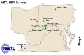
Figure 1. HEM surveys of coal mining areas.
Airborne Electromagnetic Surveying
Electromagnetic (EM) conductivity techniques measure the apparent conductivity of the earth by applying a time varying magnetic field. The applied magnetic field induces eddy currents within subsurface conductors (mine pools in this case), which in turn generate a secondary magnetic field that can be detected at the ground's surface or from low-flying aircraft. The strength of both the primary (applied) magnetic field (![]() p) and secondary magnetic field (
p) and secondary magnetic field (![]() s) are measured using a receiver antenna and are distinguished based on intensity, phase, or direction. The ratio (
s) are measured using a receiver antenna and are distinguished based on intensity, phase, or direction. The ratio (![]() s/
s/![]() p) is linearly proportional to the ground conductivity.
p) is linearly proportional to the ground conductivity.
![]() s/
s/![]() p= i
p= i![]()
![]() o
o![]() s2/4
s2/4
where: ![]() s= secondary magnetic field;
s= secondary magnetic field; ![]() p= primary magnetic field;
p= primary magnetic field; ![]() = 2
= 2![]() f; f = frequency (Hz);
f; f = frequency (Hz); ![]() o= magnetic permeability of free space;
o= magnetic permeability of free space; ![]() = ground conductivity (siemans/m); s = distance between transmitter and receiver coils (m); and i = √ -1.
= ground conductivity (siemans/m); s = distance between transmitter and receiver coils (m); and i = √ -1.
The above expression is valid only if a low induction number can be assumed. The induction number (B) is dependent on the intercoil spacing (s) and the skin depth (![]() ) where
) where
B = s/![]()
(McNeill, 1980). The assumption of low induction number is generally valid in coal mining areas where ground conductivities are almost always less than 100 mS/m. The skin depth is described as the depth at which the amplitude of the electromagnetic field drops to 1/e of the source amplitude (e being the natural base). Skin depth is a function of the transmitter frequency (f) and ground resistivity (![]() ). The exploration depth or skin depth (
). The exploration depth or skin depth (![]() ) for EM conductivity is determined by;
) for EM conductivity is determined by;
![]() = 504 √(
= 504 √(![]() /f)
/f)
As implied by this relationship, increases in ground conductivity and frequency will decrease the skin depth, and therefore, decrease the depth of investigation (McNeill, 1980). The practical exploration depth of EM methods is generally taken to be about one half of the skin depth.
Frequency Domain Electromagnetic Surveys
Frequency domain electromagnetic (FDEM) surveys use transmitter-receiver coil pair antennae operating at different frequencies to obtain different exploration depths. Because exploration depth varies inversely with transmitter frequency, five or six transmitter-receiver coil pairs operating at selected frequencies between 400 Hz and 100 kHz can determine the vertical distribution of conductivity to a depth of about 100 m in typical coal-bearing strata.
The ability of EM methods to detect a mine pool depends on the thickness and conductivity of the mine pool as well as the thickness and conductivity of conductors in the overlying strata. Figure 2 shows the simulated response of an FDEM system to a 2-m thick mine pool with a conductivity of 500 mS/m beneath increasing overburden with an average conductivity of 20 mS/m. This simulation suggests that the mine pool could be detected beneath as much as 50 m of overburden.
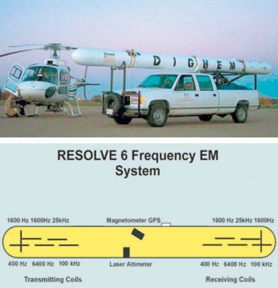
Figure 2. FDEM system showing the location and orientation of transmitter and receiver coils (Fugro Airborne Surveys, 2003).
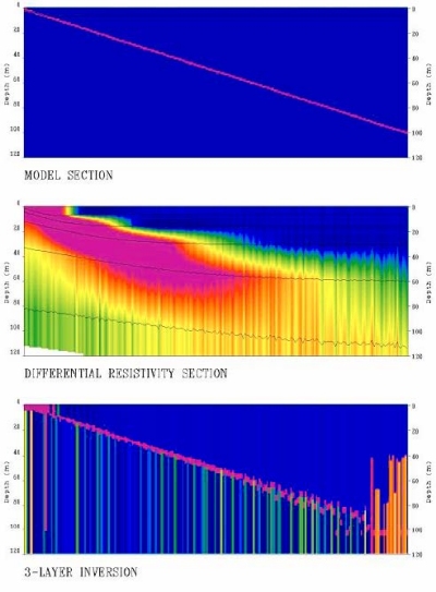
Figure 3. Modeled response of HEM system to a 2-m thick mine pool with 500 mS/m conductivity beneath overburden with average conductivity of 20 mS/m (from Hodges 2002)
Time Domain Electromagnetic Surveys
Time domain electromagnetic surveys (TDEM) differ from FDEM surveys in the equipment that is used and in the manner that data are acquired. Compared with FDEM, TDEM uses a larger, more powerful transmitter coil that operates at only one frequency. The primary magnetic field that is generated penetrates deeper into the ground, providing a deeper exploration depth. Unlike FDEM, where the transmitter and receiver are constantly on, with TDEM, the receiver is only turned on after the transmitter has been turned off. When the transmitter is on, eddy currents flow within conductors in the ground until a magnetic field is established. When the primary field is turned off, eddy currents flow again giving rise to a secondary magnetic field that is measured by the receiver. With TDEM, the measurement of weak secondary magnetic fields is made in the absence of the much stronger primary field. TDEM data consists of secondary magnetic field measurements made during numerous preset time windows following turn-off of the primary field. This information can be processed to obtain the vertical distribution of conductivity within the ground because early times indicate near-surface conductivity and late times indicate the conductivity deeper within the earth.
The advantages of TDEM over FDEM include:
- greater exploration depth
- better depth resolution
- less noise
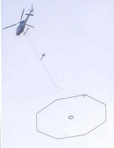
Figure 4. Helicopter-mounted TDEM system
Airborne EM Surveys of Coal Mining Regions
Airborne electromagnetic surveys have been conducted from both helicopters and fixed-wing aircraft, but only helicopters are used for surveying coal mining areas in the eastern United States because of rugged topography. Electromagnetic surveys require low-altitude flight (nominal sensor altitude=30 m above ground level) to maximize sensitivity and spatial resolution. Only helicopters can maintain a constant sensor altitude while flying over rapidly varying terrain.
NETL has conducted HEM surveys of eight coal mining areas in the eastern United States. Of these, seven surveys were conducted using frequency domain electromagnetic surveying methods. The eighth and most recent survey was just completed using a newly developed, helicopter time domain electromagnetic surveying method.
Results and Discussion
Location of mine pools
Helicopter FDEM surveys identified approximately 12 mine pools in shallow (<50-m deep) underground coal mines within the Kettle Creek Watershed in north-central Pennsylvania. Figure 5 is a map of known underground mine workings with a conductivity/depth image (CDI) for one of the flight lines that cross the mine pool. Where mine maps are available, the location of mine pools coincide with the location of known mine workings.
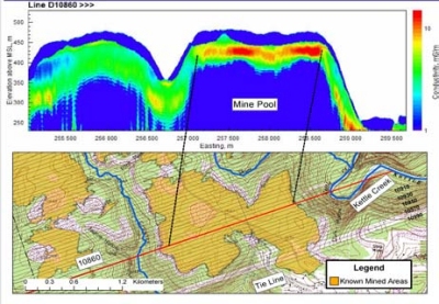
Figure 5. Inferred mine pools (red and yellow zones) correspond to mapped underground coal mine workings
However, underground mine pools were not detected by the FDEM survey of the Fall Run Watershed in eastern Ohio (figure 6). At this location, the mine workings are deeper than 50 m, and mine pools can only be identified near outcrop. Moreover, the average overburden conductivity was greater in Fall Run Watershed, which further limited exploration depth.
Helicopter mounted TDEM was used to survey four areas containing flooded underground mines in southwestern Virginia. The depth of the underground mines in these areas ranged from 0 to 200 m. This survey was performed in late May and data processing was incomplete at the time this manuscript was prepared.
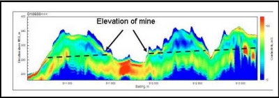
Figure 6. FDEM cannot detect mine pools at depths greater than 50 m.
Conclusions
NETL has demonstrated that helicopter FDEM surveys are capable of detecting flooded mine workings to a depth of about 50 m. This result agrees well with the maximum depth predicted by forward models (figure 2). However, other NETL surveys have shown that FDEM cannot detect known mine pools at depths of 80-90 m. Currently, we believe that 50 m is the maximum depth for FDEM systems.
TDEM systems theoretically have a greater exploration depth than FDEM. A helicopter-mounted TDEM system has been tested recently for flooded mines at depths between 0-200 m. Results of this work are not yet available.
References
Fugro Airborne Surveys (2003), RESOLVE, http://www.fugroairborne.com/Services/airborne/EM/resolve/index.shtml, April 23, 2003
Hodges G (2002) Written communication. Fugro Airborne Surveys, Mississauga, Ontario, Canada
McNeill J. D. (1980) Electromagnetic terrain conductivity measurement at low induction numbers. Technical Note TN-6, Geonics Limited, 15 p.