

Archived: TRB Mid-Year Meeting Symposium On The Effects of Abandoned Underground Mines on Transportation Facilities
The Interstate Technical Group On Abandoned Underground Mines
Thomas E. Lefchik, P.E.(1) and L. Rick Ruegsegger, P.E.(2)
Abstract
Safety problems for travelers caused by sinkholes and slides initiated by abandoned underground mines are a growing concern as the mines in the United States deteriorate with age. Transportation agencies are faced with a potentially large number of sites that need to be addressed and a lack of knowledge and experience in dealing with these sites. The potential liability that these sites present can be significant.
The Ohio Department of Transportation (ODOT) developed an Abandoned Underground Mine Inventory and Risk Assessment process as a proactive method of locating and assessing the safety of mine sites underlying highways in the state of Ohio. The process is documented in an ODOT technical manual (ODOT, 1998) and a Federal Highway Administration (FHWA) publication (FHWA, 1999).
ODOT was in contact with several states and mine related agencies throughout the development of the inventory and risk assessment process and the investigation and remediation of several sites. During the development of the process, it was discovered that no states or other entities had a process to systematically locate and assess the safety of roadways underlain by abandoned underground mines. In addition, the knowledge and experience of the state DOT's was not being widely shared among the states.
Consequently the Interstate Technical Group on Abandoned Underground Mines was conceived. This group is composed of technically oriented individuals responsible for remediation of underground mines beneath highways in fourteen states and one Canadian province. The goals of the group are to 1.) generate and disseminate information and 2.) obtain outside funding or cooperatively share in the costs of related mutually beneficial efforts.
The group is growing and sharing information through workshops, a group interactive web site, and informal communication.
Introduction
A twelve foot (4 meter) section of Interstate Route 70 in Guernsey County, Ohio suddenly collapsed due to abandoned underground mine subsidence on March 5, 1995. This collapse resulted in near tragedy and the subsequent closure of this vital roadway for four months.
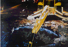 |
This incident was startling and attracted statewide and nationwide attention. However, it was not the first ODOT encounter with mines beneath roadways nor would it be the last. Discussions with ODOT maintenance personnel following the I-70 collapse revealed that subsidences due to mine collapse at other locations were periodically filled by maintenance crews. One location requiring periodic attention due to these subsidences was the interchange of I-70 and I-77, at one time the largest interchange in the United States.
It was becoming evident that mines beneath and adjacent to roadways were a past, present, and unavoidable future problem that was growing in proportions due to the increasing age of the mines. The Ohio Department of Natural Resources, Division of Geological Survey has detailed abandonment maps for approximately 4,200 mines in Ohio and estimates that there are approximately an additional 2000 more abandoned mines for which no detailed maps are available. (Crowell, 1997)
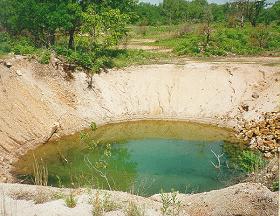
Mines present a danger to the traveling public due to the potential for the collapse of the pavement, the formation of sinkholes in the shoulder and side slopes, the settlement of bridges and other structures, and the initiation of slides by mine collapse or mine drainage. The I-70 site in Guernsey County underscored the potential for severe danger to the traveling public and the potential liability to the state DOT.
 |
These revelations caused ODOT personnel to realize that a systematic process was needed to address the issue. The number of sites was unknown but could be as many as 1000. Therefore it would be impossible to work on every potential site in the state.
Consequently, ODOT developed an Abandoned Underground Mine Inventory and Risk Assessment process as a proactive method of locating and assessing the safety of mine sites underlying highways. The process is documented in an ODOT technical manual (ODOT, 1998) and a FHWA publication (FHWA, 1999) which can be purchased by the general public.
State Contacts
During the development of the manual, ODOT contacted numerous state DOT's, state agencies and federal agencies to determine what those states and agencies were doing to locate, investigate, rate, remediate, and monitor sites where abandoned mines are located beneath roadways. Many state DOT's and state and federal agencies were very helpful in providing guidance and in sharing their knowledge and experience.
However, it became evident that the knowledge and experience of the state DOT's was not being widely shared among the states. The various state DOT's were wrestling with the same issues and problems that the Ohio DOT was now facing. They each had made some attempts, both successful and unsuccessful, in various methods and procedures. Some of the successes and failures were repeated in some states without the knowledge of the experiences of other states.
 |
The personnel dealing with the mine issues in the states were also encumbered with numerous other responsibilities and pressing issues. Consequently the personnel in each state could only expend a limited effort on mine related responsibilities.
The problems of mines beneath roadways is widespread. The United States Department of the Interior, Office of Surface Mining Reclamation and Enforcement (OSMRE) maintains a repository of mine maps (mostly coal mines). This repository contains maps for mines in 45 states. (OSMRE 1997) Maps are not available at the repository for all mines. Consequently the number of mines and the number of states with mines is larger.
Many transportation agencies are faced with a potentially large number of sites where mines lie beneath roadways. These sites need to be assessed and/or addressed. However, these agencies are hindered by a lack of information, knowledge, experience, resources, and time. This has hampered progress in adopting and developing methods to systematically locate, inventory, investigate, rate, remediate, and monitor the sites.
Workshop
The Ohio DOT decided to host a workshop to bring together the state DOT's and state and federal agencies to share their knowledge and experiences. Funding for the workshop was provided by the Federal Highway Administration. The workshop was held on September 16-18, 1997.
The following nine states and one turnpike authority participated in the workshop:
- Illinois
- Kansas
- Kentucky
- Maryland
- Missouri
- New York
- North Dakota
- Ohio
- Pennsylvania
- Pennsylvania Turnpike
In addition the following seven state and federal agencies participated:
- United States Department of Interior, Office of Surface Mining
- United States Geological Survey
- United States Department of Transportation, Federal Highway Administration (FHWA)
- Ohio Department of Natural Resources
- Ohio Mine Subsidence Inventory Underwriting Association
- Ohio Environmental Protection Agency
- Ohio Department of Development
The primary focus of the discussions was on procedures to inventory and assess sites. However, other aspects of dealing with mines beneath roadways; such as methods of locating mine voids, monitoring methods, and remediation methods; were discussed as well.
The discussions at the workshop resulted in a lively exchange of information and all participants benefitted. As a result of the success of the workshop, the participants expressed a desire to continue their cooperation and sharing of information.
Group Formation
Consequently the Interstate Technical Group on Abandoned Underground Mines was conceived.
It was agreed that the group would be comprised of technically oriented individuals responsible for the remediation of underground mines beneath highways. The group expressed a desire to continue to exchange information individually and as a group with other state and federal agencies, private industry and firms, as well as other organizations. But it was believed that group goals could best be achieved with a focused membership.
The following are the current group members:
- Arizona
- Federal Highway Administration
- Federal Railroad Administration
- Illinois
- Indiana
- Iowa
- Kansas
- Kentucky
- Maryland
- Michigan
- Missouri
- New York
- North Dakota
- Ohio
- Ontario, Canada
- Pennsylvania
- Pennsylvania Turnpike
- West Virginia
The goals of the group are to:
- Generate and disseminate information.
- Obtain outside funding or cooperatively share in the costs of research or other related mutually beneficial efforts.
The expected benefits to be derived from the achievement of the above goals are:
- Increased efficiency and effectiveness of each state's operations
- Enhanced safety of the traveling public.
Group Communication
Various means are being pursued to fulfill the goal of generating and disseminating information. First, and perhaps most important, the group members developed contacts with each other through the workshop in Ohio and subsequent workshops. This has led to informal communication between various members through telephone and e-mail communications.
Group Web Site
Another means of generating and disseminating information is an interactive internet web site currently hosted by the Federal Highway Administration at: https://www.fhwa.dot.gov/engineering/geotech/hazards/mine/mine.cfm. This web site features contact information for all members, information regarding current and completed projects and research, a discussion board for active group communication, summaries of completed workshops and information for the upcoming workshop, a copy of the Ohio Department of Transportation's mine manual, links to related web sites, and a multimedia page. As money and time become available it is hoped that other features can be added to the site.
|
|---|
The most significant features of the site are the interactive pages.
The page containing information regarding current and completed research and projects is under development and will be updated by the individual state members. This will help to assure that the information is accurate and up-to-date. The page will include the type of work, location, date completed, degree of success, and whether a report is available.
The discussion board is used by the group members to post questions and allows the other members to post responses. Not only does this allow group members to draw on the knowledge and experience of the other members but it also will provide a library of useful information that can be accessed through a search function so that members and the public can draw upon the stored responses.
Additional Workshops
Another workshop was hosted by the Missouri Department of Transportation in St. Louis in August 1998. This workshop focused on geophysical methods of investigation and monitoring but also included discussions on various other issues. Participants included six states - Iowa, Illinois, Kansas, Missouri, Ohio, and Pennsylvania and one state and one federal agency. In addition, there were presentations and participation by seven private practice firms. At this workshop the group expressed a desire to meet every two years in workshops.
Another workshop was hosted by the Kansas Department of Transportation in Kansas City in April 2000. Nine member states plus federal and state agencies, private consulting firms, industry, and academia participated in this workshop.
Some significant issues were discussed at the Kansas workshop. The workshop opened with an afternoon of presentations by the various participating transportation authorities. The balance of the workshop presentations focused on investigating, monitoring, and remediating abandoned underground mines beneath roadways. Presentations were made regarding the roadway applications of geophysical techniques such as ground penetrating radar, seismic reflection, borehole tomography, time domain reflectometry (TDR), surface wave inversion and attenuation, micro-seismic monitoring, and other technical subjects. All of these presentations included case studies demonstrating the application of the different geophysical techniques to roadway locations underlain by abandoned underground mines.
The workshop also included a field trip to an abandoned underground limestone mine which is being converted for use as commercial space and as a local college's library.
The exchange of information is a primary goal of the group. At the Kansas workshop it was noted that other modes of transportation, specifically railroads, face the same problems with abandoned mine hazards. Consequently the group agreed to invite other modes of transportation to become involved with the group. In addition, other mine related agencies and firms are involved with many of the same issues and use many of the same methods of monitoring, investigation and remediation. Therefore, it would be mutually beneficial to involve these groups to a greater degree.
Other organizational affiliations were investigated but it appears that the group will remain independent and informally organized.
The next workshop will be hosted by Illinois and Iowa in 2002.
Research
There has not yet been any active sharing of research cost or effort by the group. However a significant benefit has been achieved through the sharing of information which prevents states from pursuing unsuccessful efforts and concentrating on trying untried methods, making modifications to unsuccessful methods, or using successful methods in untried conditions. This is an informal method of sharing the research effort which is already showing a benefit.
It is likely that group members will generally each choose research topics that suit their state needs or interests and share the results with other states. The use of pooled funds for a common research project remains a possibility. No specific research projects have yet been identified for the application of pooled funds or outside funding. Also no sources of outside funds for research have been identified.
Summary
The Interstate Technical Group on Abandoned Underground Mines is meeting its original goals to:
1.) generate and disseminate information and 2.) obtain outside funding or cooperatively share in the costs of research or other related mutually beneficial efforts.
The expected benefits of:
1.) increased efficiency and effectiveness of each state's operations and
2.) enhanced safety of the traveling public
are currently being realized and are expected to be realized in a greater degree in the future.
The membership of the group has grown to 18 members and remains open to interested agencies.
References
Crowell, Douglas L., February 1997, Mine Subsidence, Geofacts No. 12, Ohio Department of Natural Resources, Division of Geological Survey, 4 p.
FHWA, May, 1999, Manual for Abandoned Underground Mine Inventory and Risk Assessment, The US Department of Transportation, Federal Highway Administration, Office of Infrastructure, Publication No. FHWA-IF-99-0007
ODOT, May 15, 1998, Manual for Abandoned Underground Mine Inventory and risk Assessment, Ohio Department of Transportation, Office of Materials Management
OSMRE Pamphlet, November 1997, Mine Map Repositories: A Source of Mine Map Data, The US Department of the Interior, Office of Surface Mining Reclamation and Enforcement, Program Information Development, 8 p.
1. 1Assistant Bridge Engineer, Federal Highway Administration, Ohio Division, 200 North High Street, Columbus, Ohio 43215
2. 2Special Projects Coordinator, Ohio Department of Transportation, Office of Roadway Engineering, Soils Section, 1600 W. Broad Street, Room 2033, Columbus, Ohio 43223