

| << Previous | Contents | Next >> |
Geotechnical Aspects of Pavements Reference Manual
Chapter 5.0 Geotechnical Inputs For Pavement Design
5.1 Introduction
This chapter describes the determination of the specific geotechnical inputs required for the design of flexible and rigid pavements. Although the focus here is strictly on geotechnical inputs, there is obviously much other important information required for pavement design, including traffic characteristics, material properties for the bound asphalt and/or Portland cement concrete layers, desired reliability, and other details. These inputs are usually provided by agency units other than the geotechnical group.
Most of the inputs described in this chapter relate to the material properties of the unbound pavement layers and subgrade soil. Other required inputs include geometric information like layer thickness, but these are generally self-explanatory and are not discussed here. Environmental/climate inputs are also covered in this chapter. Although these inputs are not "geotechnical" per se, they directly influence the behavior of the unbound materials through their effects on moisture content and freeze/thaw cycles. In addition, in many agencies, the group responsible for determining the environmental inputs is poorly defined, and thus this responsibility may end up with the geotechnical group.
The coverage of the material in this chapter is guided by several considerations:
- Only the explicit design inputs are treated. As described in Chapter 3, there may be other geotechnical issues (e.g., embankment slope stability) that can have a significant impact on pavement performance but that are not considered explicitly in the pavement design process.
- Project-specific measured input parameters are often unavailable at design time, particularly for preliminary design. This is especially true for material properties. Consequently, much emphasis is placed in this chapter on "typical" values and/or empirical correlations that can be used to estimate the design inputs. These estimates can be used for preliminary design, sensitivity studies, and other purposes. Clearly, though, project-specific measured values are preferred for final design.
- Many material property inputs can either be determined from laboratory or field tests. Field testing is covered in Chapter 4, and appropriate links to the Chapter 4 material are included here where appropriate.
- The treatment in this chapter attempts to balance coverage between the current empirical 1993 AASHTO Design Guide and the forthcoming mechanistic-empirical NCHRP 1-37A design approach (hereafter referred to as the NCHRP 1-37A Design Guide). Although there is some overlap in the geotechnical inputs required by these two design approaches (e.g., subgrade resilient modulus), there are substantial differences. The inputs to the 1993 AASHTO Guide are fewer in number and mostly empirical (e.g., layer drainage coefficients), while the inputs to the NCHRP 1-37A Guide are more numerous and fundamental (e.g., hydraulic conductivity vs. moisture content relations).
- Only design inputs are described in this chapter. In cases where some intermediate analysis is required to determine the design input (e.g., for effective modulus of subgrade reaction in the 1993 Guide-see Section 5.4.6), the analysis methodology is described here, as well. The usage of the design inputs in the overall design calculations is described separately in Appendices C and D for the 1993 and NCHRP 1-37A Design Guides, respectively.
One consequence of all of the above is that this chapter is quite long; this is necessary to give sufficient coverage to all of the diverse geotechnical inputs required by the two design procedures. First, the geotechnical inputs required by the 1993 AASHTO and NCHRP 1-37A Design Guides are summarized (Section 5.2). Then, the geotechnical inputs are described in detail by category. The following is a road map of the sections in this chapter that describe the various categories of geotechnical design inputs:
- 5.2 REQUIRED GEOTECHNICAL INPUTS
- 5.2.1 1993 AASHTO Design Guide
- 5.2.2 NCHRP 1-37A Design Guide
- 5.2.3 Other Geotechnical Properties
- 5.3 PHYSICAL PROPERTIES
- 5.3.1 Weight-Volume Relationships
- 5.3.2 Physical Property Determination
- 5.3.3 Problem Soil Identification
- 5.3.4 Other Aggregate Tests
- 5.4 MECHANICAL PROPERTIES
- 5.4.1 California Bearing Ratio (CBR)
- 5.4.2 Stabilometer (R-Value)
- 5.4.3 Elastic (Resilient) Modulus
- 5.4.4 Poisson's Ratio
- 5.4.5 Structural Layer Coefficients
- 5.4.6 Modulus of Subgrade Reaction
- 5.4.7 Interface Friction
- 5.4.8 Permanent Deformation Characteristics
- 5.4.9 Coefficient of Lateral Pressure
- 5.5 THERMO-HYDRAULIC PROPERTIES
- 5.5.1 1993 AASHTO Guide
- 5.5.2 NCHRP 1-37A Design Guide
- 5.6 ENVIRONMENT/CLIMATE INPUTS
- 5.6.1 1993 AASHTO Guide
- 5.6.2 NCHRP 1-37A Design Guide
The chapter concludes with a section describing the development of final design values for each input when there are several estimates, e.g., material properties measured both in the field and in the laboratory. Most of the design inputs also exhibit significant spatial, temporal, and inherent variability. All of these issues must be reconciled to develop defensible input values for use in the final pavement design.
5.2 Required Geotechnical Inputs
5.2.1 1993 AASHTO Design Guide
As described previously in Chapter 3, the AASHTO Pavement Design Guide has evolved through several versions over the 40+ years since the AASHO Road Test. The current version is the 1993 Guide. The geotechnical inputs required for flexible pavement design using the 1993 Guide are summarized in Table 5-1. Also shown are cross references to the sections in this manual in which the determination of the respective geotechnical inputs are described. As previously described in Chapter 3, the geotechnical inputs for the 1986 Guide are identical to those for the 1993 Guide. Note that the thicknesses Di for the unbound layers are included as flexible pavement geotechnical inputs in Table 5-1; although these would typically be considered outputs from the design (i.e., determined from SN and the other defined inputs), there may be cases where the layer thicknesses are fixed and for which the design then focuses on selecting layer materials having sufficient structural capacity.
| Property | Description | Section |
|---|---|---|
| MR | Resilient modulus of subgrade | 5.4.3 |
| EBS | Resilient modulus of base (used to determine structural layer coefficient) | 5.4.3 |
| m2 | Moisture coefficient for base layer | 5.5.1 |
| D2 | Thickness of base layer | |
| ESB | Resilient modulus of subbase (used to determine structural layer coefficient) | 5.4.3 |
| m3 | Moisture coefficient for subbase layer | 5.5.1 |
| D3 | Thickness of subbase layer | |
| θ | Swell rate | 5.6.1 |
| VR | Maximum potential swell | 5.6.1 |
| PS | Probability of swelling | 5.6.1 |
| φ | Frost heave rate | 5.6.1 |
| ΔPSIMAX | Maximum potential serviceability loss from frost heave | 5.6.1 |
| PF | Probability of frost heave | 5.6.1 |
Note: Additional sets of layer properties (Ei, mi, Di) are required if there are more than two unbound layers in the pavement structure (exclusive of the natural subgrade).
The geotechnical inputs required for rigid pavement design using the 1993 Guide are summarized in Table 5-2. Again, these inputs are identical to those for the 1986 Guide. The first five properties in Table 5-2 are used to determine the effective modulus of subgrade reaction k in the 1993 Guide procedure. The geotechnical inputs required for rigid pavement design using the optional alternate approach in the 1998 supplement are the same as for the 1993 approach; only the analysis procedure changed in the 1998 supplement.
| Property | Description | Section |
|---|---|---|
| MR | Resilient modulus of subgrade | 5.4.3 |
| ESB | Resilient modulus of subbase | 5.4.3 |
| DSB | Thickness of subbase | |
| DSG | Depth from top of subgrade to rigid foundation | |
| LS | Loss of Support factor | 5.4.6 |
| Cd | Drainage factor | 5.5.1 |
| F | Friction factor (for reinforcement design in JRCP) | 5.4.7 |
| θ | Swell rate | 5.6.1 |
| VR | Maximum potential swell | 5.6.1 |
| PS | Probability of swelling | 5.6.1 |
| φ | Frost heave rate | 5.6.1 |
| ΔPSIMAX | Maximum potential serviceability loss from frost heave | 5.6.1 |
| PF | Probability of frost heave | 5.6.1 |
The last six parameters in both tables are the environmental parameters required by the 1993 Guide for determining the serviceability loss due to swelling of expansive subgrade soils and frost heave. Although these are not geotechnical parameters in the strictest sense, the detrimental effects of swelling and frost heave are concentrated in the subgrade and other unbound layers and thus are important geotechnical aspects of pavement design.
5.2.2 NCHRP 1-37A Design Guide
The mechanistic-empirical methodology that is the basis of the NCHRP 1-37A Design Guide requires substantially more input information than needed by the empirical design procedures in the 1993 AASHTO Guide. These inputs also tend to be more fundamental quantities, as compared to the often empirical inputs in the 1993 Guide. This is understandable given the inherent differences between mechanistic-empirical and empirical design methodologies.
Hierarchical Approach to Design Inputs
The level of design effort in any engineering design should be commensurate with the significance of the project being designed. Low-volume secondary road pavements do not require-and most agencies do not have the resources to provide-the same level of design effort as high-volume urban primary roads.
In recognition of this reality, a hierarchical approach has been developed for determining the pavement design inputs in the NCHRP 1-37A Design Guide. The hierarchical approach is based on the philosophy that the level of engineering effort exerted in determining the design inputs, including the material property values, should be consistent with the relative importance, size, and cost of the design project. Three levels are provided for the design inputs in the NCHRP 1-37A Guide:
- Level 1 inputs provide the highest level of accuracy and the lowest level of uncertainty. Level 1 inputs would typically be used for designing heavily trafficked pavements or wherever there are serious safety or economic consequences of early failure. Level 1 material inputs require laboratory or field evaluation, such as resilient modulus testing or non-destructive deflection testing. Level 1 inputs require more resources and time to obtain than the other lower levels.
- Level 2 inputs provide an intermediate level of accuracy and are closest to the typical procedures used with earlier editions of the AASHTO Pavement Design Guides. This level could be used when resources or testing equipment are not available for Level 1 characterization. Level 2 inputs would typically be derived from a limited testing program or estimated via correlations or experience (possibly from an agency database). Resilient modulus estimated from correlations with measured CBR values is one example of a Level 2 material input.
- Level 3 inputs provide the lowest level of accuracy. This level might be used for designs in which there are minimal consequences of early failure (e.g., low-volume roads). Level 3 material inputs typically are default values that are based on local agency experience. A default resilient modulus based on AASHTO soil class is an example of a Level 3 material input.
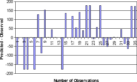
Although it is intuitively clear that higher level (i.e., higher quality) design inputs will provide more precise estimates of pavement performance, the current state-of-the-art of pavement design and the limited availability of Level 1 input data make it difficult to quantify these benefits at present. One exception to this is thermal cracking prediction in the NCHRP 1-37A Design Guide. Complete Level 1 material property and environmental data were available from the U.S. and Canadian Strategic Highway Research Programs for approximately 35 pavement sites in the northern United States and Canada. Predictions of thermal cracking were made based on these Level 1 material inputs as well as on Level 3 default material properties. Figure 5-1 summarizes the differences between predicted and observed thermal cracking in units of lineal feet of cracking per 500 feet of pavement length for each of the field sites based on the Level 1 material inputs; Figure 5-2 summarizes the same results based on the Level 3 material inputs. The comparison of these two figures clearly shows that the higher quality Level 1 material inputs dramatically reduce the variability between predicted and observed cracking.
Figure 5-1. Thermal crack prediction from NCHRP 1-37A Design Guide using Level 1 material inputs.
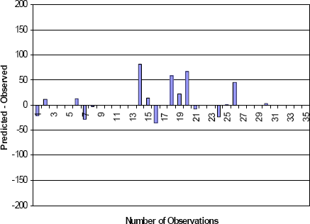
Figure 5-2. Thermal crack prediction from NCHRP 1-37A Design Guide using Level 3 material inputs.
Design inputs in the NCHRP 1-37A methodology may be specified using a mix of levels for any given project. For example, the modulus of rupture of a concrete surface layer may be specified as a Level 1 input, while the traffic load spectra are determined using a Level 2 approach, and the subgrade resilient modulus via a Level 3 estimate based on subgrade soil class. The computational algorithms and distress models in the NCHRP 1-37A Design Guide (see Appendix D) are applied in the same way regardless of the input levels. However, the higher level inputs implicitly increase the accuracy and reliability of the predicted pavement performance.
In summary, the advantages of the hierarchical approach for the material and other design inputs are as follows:
- It provides the engineer with great flexibility in selecting an engineering approach consistent with the size, cost, and overall importance of the project.
- It allows each agency to develop an initial design methodology consistent with its internal technical capabilities.
- It provides a very convenient method for gradually increasing over time the technical skills and sophistication within the organization.
- In concept, it provides the most accurate and cost-efficient design consistent with agency financial and technical resources.
Required Geotechnical Inputs
The geotechnical inputs for the NCHRP 1-37A Design Guide are organized into the following categories:
- Mechanical properties that are used in an analysis model to relate applied structural loads to structural response (Table 5-3 and Table 5-4).
- Thermo-hydraulic inputs that are used to relate environmental influences to the thermal and hydraulic state of the system (Table 5-5).
- Distress model properties that enter directly in the empirical models for pavement performance (Table 5-6).
As described previously, the NCHRP 1-37A Design Guide provides for three different hierarchical levels of input quality: Level 1 (highest), Level 2 (intermediate), and Level 3 (lowest). For any given input parameter, different properties may be required for Level 1 vs. Level 2 vs. Level 3 inputs. For example, a Level 1 estimate of subgrade resilient modulus for new construction requires laboratory-measured properties, while Level 2 instead requires CBR or other similar index properties, and Level 3 requires only the AASHTO or USCS soil class. The hierarchical levels for each of the geotechnical inputs are included in Table 5-3 through Table 5-6. The NCHRP 1-37A Guide recommends that the best available data (the highest level of inputs) be used for design. However, it does not require the same quality level for all inputs in the design.
| Property | Description | Level | Section | ||
|---|---|---|---|---|---|
| 1 | 2 | 3 | |||
| General | |||||
| Material type | 3.3.2 | ||||
| γt | In-situ total unit weight | ||||
| K0 | Coefficient of lateral earth pressure | 5.4.9 | |||
| Stiffness/Strength of Subgrade and Unbound Layersa | |||||
| k1, k2, k3 | Nonlinear resilient modulus parameters |  b b | 5.4.3 | ||
| MR | Backcalculated resilient modulus | c | 5.4.3 | ||
| MR | Estimated resilient modulus | d | 5.4.3 | ||
| CBR | California Bearing Ratio | d | 5.4.1 | ||
| R | R-Value | d | 5.4.2 | ||
| ai | Layer coefficient | d,e | 5.4.5 | ||
| DCP | Dynamic Cone Penetration index | d | 4.5.5 | ||
| PI | Plasticity Index | d | 5.3.2 | ||
| P200 | Percent passing 0.075 mm (No. 200 sieve) | d | 5.3.2 | ||
| AASHTO soil class | 4.7.2 | ||||
| USCS soil class | 4.7.2 | ||||
| ν | Poisson's ratio | 5.4.4 | |||
| Interface friction | 5.4.7 | ||||
- Estimates of MR and ν are also required for shallow bedrock.
- For new construction/reconstruction designs only.
- Primarily for rehabilitation designs.
- For level 2, MR may be estimated directly or determined from correlations with one of the following: CBR; R; ai; DCP; or PI and P200.
- For unbound base and subbase layers only.
| Property | Description | Level | Section | ||
|---|---|---|---|---|---|
| 1 | 2 | 3 | |||
| General | |||||
| Material type | 3.3.2 | ||||
| γt | In-situ total unit weight | 5.3.2 | |||
| K0 | Coefficient of lateral earth pressure | 5.4.9 | |||
| Stiffness/Strength of Subgrade and Unbound Layersa | |||||
| kdynamic | Backcalculated modulus of subgrade reaction | b | 5.4.3 | ||
| MR | Estimated resilient modulus | c | 5.4.3 | ||
| CBR | California Bearing Ratio | c | 5.4.1 | ||
| R | R-Value | c | 5.4.2 | ||
| ai | Layer coefficient | c | 5.4.5 | ||
| DCP | Dynamic Cone Penetration index | c | 4.5.5 | ||
| PI | Plasticity Index | c | 5.3.2 | ||
| P200 | Percent passing 0.075 mm (No. 200 sieve) | c | 5.3.2 | ||
| AASHTO soil class | 4.7.2 | ||||
| USCS soil class | 4.7.2 | ||||
| ν | Poisson's ratio | 5.4.4 | |||
| Interface friction | 5.4.7 | ||||
- Estimates of MR and ν are also required for shallow bedrock in new/reconstruction designs.
- From FWD testing for rehabilitation designs. For new/reconstruction designs, kdynamic is determined from Level 2 estimates of MR.
- For Level 2, MR may be estimated directly or determined from correlations with one of the following: CBR; R; ai; DCP; or PI and P200.
| Property | Description | Level | Section | ||
|---|---|---|---|---|---|
| 1 | 2 | 3 | |||
| Groundwater depth | 5.5.2 | ||||
| Infiltration and Drainage | |||||
| Amount of infiltration | 5.5.2 | ||||
| Pavement cross slope | 5.5.2 | ||||
| Drainage path length | 5.5.2 | ||||
| Physical Properties | |||||
| Gs | Specific gravity of solids | 5.3.2 | |||
| γd max | Maximum dry unit weight | 5.3.2 | |||
| wopt | Optimum gravimetric water content | 5.3.2 | |||
| PI | Plasticity Index | 5.3.2 | |||
| D60 | Gradation coefficient | 5.3.2 | |||
| P200 | Percent passing 0.075 mm (No. 200 sieve) | 5.3.2 | |||
| Hydraulic Properties | |||||
| af, bf, cf, hr | Soil water characteristic curve parameters | 5.5.2 | |||
| ksat | Saturated hydraulic conductivity (permeability) | 5.5.2 | |||
| PI | Plasticity Index | 5.3.2 | |||
| D60 | Gradation coefficient | 5.3.2 | |||
| P200 | Percent passing 0.075 mm (No. 200 sieve) | 5.3.2 | |||
| Thermal Properties | |||||
| K | Dry thermal conductivity | 5.5.2 | |||
| Q | Dry heat capacity | 5.5.2 | |||
| AASHTO soil class | 4.7.2 | ||||
| Property | Description | Level | Section | ||
|---|---|---|---|---|---|
| 1 | 2 | 3 | |||
| k1 | Rutting parameter (Tseng and Lytton model) | 5.4.8 | |||
5.2.3 Other Geotechnical Properties
In addition to the explicit design inputs listed in Table 5-1 and Table 5-2 for the 1993 AASHTO Guide and Table 5-3 through Table 5-6 for the NCHRP 1-37A Guide, other geotechnical properties are typically required during pavement design and construction. These include standard properties required for soil identification and classification, compaction control, and field QC/QA.
5.3 Physical Properties
Physical properties provide the most basic description of unbound materials. These properties are also often used in correlations for more fundamental engineering properties, such as stiffness or permeability. The principal physical properties of interest are specific gravity of solids, water content, unit weight (density), gradation characteristics, plasticity (Atterberg limits), classification, and compaction characteristics.
5.3.1 Weight-Volume Relationships
It is useful to review some common soil mechanics terminology and fundamental weight and volume relationships before describing the various soil test methods. Basic soil mechanics textbooks should be consulted for further explanation.
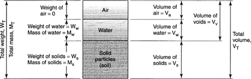
A sample of soil is a multi-phase material composed of solid soil grains, water, and air (Figure 5-3). The weight and volume of a soil sample depends on the specific gravity of the soil grains (solids), the size of the space between soil grains (voids and pores), and the amount of void space filled with water (moisture content and degree of saturation). Common terms associated with weight-volume relationships are shown in Table 5-7. Of particular note is the void ratio e, which is a general indicator of the relative strength and compressibility of a soil sample; i.e., low void ratios generally indicate strong soils of low compressibility, while high void ratios are often indicative of weak and highly compressible soils. Selected weight-volume (unit weight) relations are presented in Table 5-8. Typical values for porosity, void ratio, water content, and unit weight are presented in Table 5-9 for a range of soil types.
Figure 5-3. Relationships between volume and weight/mass of bulk soil (McCarthy, 2002).
| Property | Symbol | Units1 | How obtained (AASHTO/ASTM) | Direct Applications |
|---|---|---|---|---|
| Moisture Content | w | D | By measurement (T 265/ D 4959) | Classification and weight-volume relations |
| Specific Gravity | Gs | D | By measurement (T 100/D 854) | Volume computations |
| Unit Weight | γ | FL-3 | By measurement or from weight-volume relations | Classification and pressure computations |
| Porosity | n | D | From weight-volume relations | Defines relative volume of solids to total volume of soil |
| Void Ratio | e | D | From weight-volume relations | Defines relative volume of voids to volume of solids |
- F = Force or weight; L = Length; D = Dimensionless. Although by definition, moisture content is a dimensionless fraction (ratio of weight of water to weight of solids), it is commonly reported in percent by multiplying the fraction by 100.
| Case | Relationship | Applicable Geomaterials | |||||
|---|---|---|---|---|---|---|---|
| Soil Identities: |
| All types of soils & rocks | |||||
| Limiting Unit Weight | Solid phase only: w = e = 0: γrock = Gsγw | Maximum expected value for solid silica is 27 kN/m3 | |||||
| Dry Unit Weight | For w = 0 (all air in void space): γd = Gsγw/(1+e) | Use for clean sands and soils above groundwater table | |||||
| Moist Unit Weight (Total Unit Weight) | Variable amounts of air & water: γt = Gsγw(1+w)/(1+e) with e = Gsw/S | Partially-saturated soils above water table; depends on degree of saturation (S, as decimal). | |||||
| Saturated Unit Weight | Set S = 1 (all voids with water): γsat = γw (Gs+e)/(1+e) | All soils below water table; Saturated clays & silts above water table with full capillarity. | |||||
| Hierarchy: | γd ≤ γt ≤ γsat < γrock | Check on relative values |
Note: γw = 9.8 kN/m3 (62.4 pcf) for fresh water.
| Soil Type | Porosity n | Void Ratio e | Water Content w | Unit Weight | |||
|---|---|---|---|---|---|---|---|
| kN/m3 | lb/cu ft | ||||||
| γd | γsat | γd | γsat | ||||
| Uniform sand (loose) | 0.46 | 0.85 | 32% | 14.1 | 18.5 | 90 | 118 |
| Uniform sand (dense) | 0.34 | 0.51 | 19% | 17.1 | 20.4 | 109 | 130 |
| Well-graded sand (loose) | 0.40 | 0.67 | 25% | 15.6 | 19.5 | 99 | 124 |
| Well-graded sand (dense) | 0.30 | 0.43 | 16% | 18.2 | 21.2 | 116 | 135 |
| Windblown silt (loose) | 0.50 | 0.99 | 21% | 13.4 | 18.2 | 85 | 116 |
| Glacial till | 0.20 | 0.25 | 9% | 20.7 | 22.8 | 132 | 145 |
| Soft glacial clay | 0.55 | 1.2 | 45% | 11.9 | 17.3 | 76 | 110 |
| Stiff glacial clay | 0.37 | 0.6 | 22% | 16.7 | 20.3 | 106 | 129 |
| Soft slightly organic clay | 0.66 | 1.9 | 70% | 9.1 | 15.4 | 58 | 98 |
| Soft very organic clay | 0.75 | 3.0 | 110% | 6.8 | 14.0 | 43 | 89 |
| Soft montmorillonitic clay | 0.84 | 5.2 | 194% | 4.2 | 12.6 | 27 | 80 |
5.3.2 Physical Property Determination
Laboratory and field methods (where appropriate) for determining the physical properties of unbound materials in pavement systems are described in the following subsections and tables. Typical values for each property are also summarized. The soil physical properties are organized into the following categories:
- Volumetric properties
- Specific gravity (Table 5-10)
- Moisture content (Table 5-11)
- Unit weight (Table 5-12)
- Compaction
- Proctor compaction tests (Table 5-13)
- Gradation
- Mechanical sieve analysis (Table 5-19)
- Hydrometer analysis (Table 5-20)
- Plasticity
- Atterberg limits (Table 5-21)
Gradation and plasticity are the principle determinants for engineering soil classification using either the AASHTO or Unified soil classification systems. Soil classification is described as part of subsurface exploration in Section 4.7.2.
The identification of problem soils (e.g., expansive clays) is typically based on their physical properties; this topic is addressed at the end of this section. Other additional tests commonly used for quality control of aggregates used in base and subbase layers and in asphalt and Portland cement concrete are also briefly summarized.
Volumetric Properties
The volumetric properties of most interest in pavement design and construction are:
- Specific gravity (Table 5-10)
- Moisture content (Table 5-11)
- Unit weight (Table 5-12)
| Description | The specific gravity of soil solids Gs is the ratio of the weight of a given volume of soil solids at a given temperature to the weight of an equal volume of distilled water at that temperature | ||||||||||
| Uses in Pavements |
| ||||||||||
| Laboratory Determination | AASHTO T 100 or ASTM D 854. | ||||||||||
| Field Measurement | Not applicable. | ||||||||||
| Commentary | Some qualifying words like true, absolute, apparent, bulk or mass, etc. are sometimes added to "specific gravity." These qualifying words modify the sense of specific gravity as to whether it refers to soil grains or to soil mass. The soil grains have permeable and impermeable voids inside them. If all the internal voids of soil grains are excluded for determining the true volume of grains, the specific gravity obtained is called absolute or true specific gravity (also called the apparent specific gravity). If the internal voids of the soil grains are included, the specific gravity obtained is called the bulk specific gravity.Complete de-airing of the soil-water mix during the test is imperative while determining the true or absolute value of specific gravity. | ||||||||||
| Typical Values (Coduto, 1999) |
|
| Description | The moisture content expresses the amount of water present in a quantity of soil. The gravimetric moisture or water content w is defined in terms of soil weight as w = Ww / Ws, where Ww is the weight of water and Ws is the weight of the soil solids in the sample. |
| Uses in Pavements |
|
| Laboratory Determination | Drying of the soil in a conventional (temperature of 110±5°C) or microwave oven to a constant weight (AASHTO T 265, ASTM D 2216/conventional oven, or ASTM D 4643/microwave). |
| Field Measurement | Nuclear gauge (ASTM D2922). |
| Commentary | Determination of the moisture or water content is one of the most commonly performed laboratory procedures for soils. The water content of soils, when combined with data obtained from other tests, produces significant information about the characteristics of the soil. For example, when the in-situ water content of a sample retrieved from below the groundwater table approaches its liquid limit, it is an indication that the soil in its natural state is susceptible to larger consolidation settlement.
For fluid flow applications, the moisture content is often expressed as the volumetric moisture content θ = Vw / Vt, where Vw is the volume of water and Vt is the total volume of the sample. Volumetric moisture content can also be determined as θ = Sn, where S is the saturation and n is the porosity. |
| Typical Values | See Table 5-9. For dry soils, w ≅ 0. For most natural soils 3 ≤ w ≤ 70%, Saturated fine-grained and organic soils may have gravimetric moisture contents in excess of 100%. |
| Description | The unit weight is the total weight divided by total volume for a soil sample. |
| Uses in Pavements |
|
| Laboratory Determination | The unit weight for undisturbed fine-grained soil samples is measured in the laboratory by weighing a portion of a soil sample and dividing by its volume. This can be done with thin-walled tube (Shelby) samples, as well as piston, Sherbrooke, Laval, and NGI samplers. Where undisturbed samples are not available (e.g., for coarse grained soils), the unit weight must be evaluated from weight-volume relationships (see Table 5-8). |
| Field Measurement | Nuclear gauge (ASTM D2922), sand cone (ASTM D1556). |
| Commentary | Unit weight is also commonly termed density.
The total unit weight is a function of the moisture content of the soil (Table 5-8). Distinctions must be maintained between dry (γd), saturated (γsat), and moist or total (γt) unit weights. The moisture content should therefore be obtained at the same time as the unit weight to allow conversion from total to dry unit weights. |
| Typical Values | See Table 5-9. |
Compaction
Soil compaction is one of the most important geotechnical concerns during the construction of highway pavements and related fills and embankments. Compaction improves the engineering properties of soils in many ways, including:
- increased elastic stiffness, which reduces short-term resilient deformations during cyclic loading.
- decreased compressibility, which reduces the potential for excessive long-term settlement.
- increased strength, which increases bearing capacity and decreases instability potential (e.g., for slopes).
- decreased hydraulic conductivity (permeability), which inhibits flow of water through the soil.
- decreased void ratio, which reduces the amount of water that can be held in the soil and, thus, helps maintain desired strength and stiffness properties.
- decreased erosion resistance.
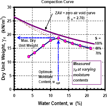
Compaction is usually quantified in terms of the equivalent dry unit weight γd of the soil as a measure of the amount of solid materials present in a unit volume. The higher the amount of solid materials, the stronger and more stable the soil will be. Standard laboratory testing (Table 5-13) involves compacting several specimens at different water contents (w). The total unit weight (γt) and water content are measured for each compacted specimen. The equivalent dry unit weight is then computed as:
(5.1)| γd = | γt |
| 1 + w |
If the specific gravity of solids Gs is known, the saturation level (S) and void ratio (e) can also be determined using the following two identities:
(5.2)Gs w = S e
(5.3)| γt = | Gs γw ( 1 + w ) |
| ( 1 + e ) |
The pairs of equivalent dry weight vs. water content values are plotted as a moisture-density of compaction curve, as in Figure 5-4. Compaction curves will typically exhibit a well defined peak corresponding to the maximum dry unit weight ((γd)max) at an optimum moisture content (wopt). It is good practice to plot the zero air voids (ZAV) curve corresponding to 100 percent saturation on the moisture-density graph (see Figure 5-4). The measured compaction curve cannot fall above the ZAV curve if the correct specific gravity has been used. The peak or maximum dry unit weight usually corresponds to saturation levels of between 70 - 85 percent.
Figure 5-4. Typical moisture-density relationship from a standard compaction test.
Relative compaction (CR) is the ratio (expressed as a percentage) of the density of compacted or natural in-situ soils to the maximum density obtainable in a specified compaction test:
(5.4)| CR = | γd | × 100% |
| ( γd )max |
Specifications often require a minimum level of relative compaction (e.g., 95%) in the construction or preparation of foundations, subgrades, pavement subbases and bases, and embankments. Requirements for compacted moisture content relative to the optimum moisture content may also be included in compaction specifications. The design and selection of methods to improve the strength and stiffness characteristics of deposits depend heavily on relative compaction.
Relative density (DR) (ASTM D 4253) is often a useful parameter in assessing the engineering characteristics of granular soils. It is defined as:
(5.5)| Dr = | emax - e | × 100% |
| emax - emin |
in which emin and emax are the minimum and maximum void ratio values for the soil. Relative density can also be expressed in terms of dry unit weights:
(5.6)| Dr = | γd - ( γd )min | ( γd )max | × 100% | ||||
| ( γd )max - ( γd )min | γd |
Table 5-14 presents a classification of soil consistency based on relative density for granular soils.
| Description | Compaction characteristics are expressed as the equivalent dry unit weight vs. moisture content relationship for a soil at a given compaction energy level. Of particular interest are the maximum equivalent dry unit weight and corresponding optimum moisture content at a given compaction energy level. |
| Uses in Pavements |
|
| Laboratory Determination | Two sets of test protocols are most commonly used:
Compaction tests are performed using disturbed, prepared soils with or without additives. Normally, soil passing the No. 4 sieve is mixed with water to form samples at various moisture contents ranging from the dry state to wet state. These samples are compacted in layers in a mold by a hammer at a specified nominal compaction energy that is a function of the number of layers, hammer weight, drop height, and number of blows (see Table 5-15). Equivalent dry unit weight is determined based on the moisture content and the unit weight of compacted soil. A curve of dry unit weight versus moisture content is plotted (Figure 5-4) and the maximum ordinate on this curve is referred to as the maximum dry unit weight ((γd)max). The water content at which this maximum occurs is termed as the optimum moisture content (wopt) or OMC. |
| Field Measurement | Field determination of moisture content (Table 5-11) and unit weight (Table 5-12) is used to check whether field-compacted material meets construction specifications. |
| Commentary | Where a variety of soils are to be used for construction, a moisture-density relationship for each major type of soil or soil mixture anticipated at the site should be established.
When additives such as Portland cement, lime, or flyash are used to determine the maximum density of mixed compacted soils in the laboratory, care should be taken to duplicate the expected delay period between mixing and compaction in the field. It should be kept in mind that these chemical additives start reacting as soon as they are added to the wet soil. They cause substantial changes in soil properties, including densities achievable by compaction. The period between mixing and compaction in the field is expected to be three hours, for example, then in the laboratory the compaction of the soil should also be delayed three hours after mixing the stabilizing additives. |
| Typical Values | See Table 5-16 for AASHTO recommended minimum compaction levels. Typical ranges for compacted unit weight and optimum moisture content for USCS and AASHTO soil classes are summarized in Table 5-17 and Table 5-18, respectively. |
| Relative Density Dr (%) | Description |
|---|---|
| 85 - 100 | Very dense |
| 65 - 85 | Dense |
| 35 - 65 | Medium dense |
| 15 - 35 | Loose |
| 0 - 15 | Very loose |
| Standard Proctor | Modified Proctor | |
|---|---|---|
| Standards | AASHTO T 99 ASTM D 698 | AASHTO T 180 ASTM D 1557 |
| Hammer weight | 5.5 lb (24.4 kN) | 10.0 lb (44.5 kN) |
| Hammer drop height | 12 in (305 mm) | 18 in (457 mm) |
| Number of soil layers | 3 | 5 |
| Hammer blows per layer | 25 | 25 |
| Total compaction energy | 12,400 ft-lb/ft3 (600 kN-m/m3) | 56,000 ft-lb/ft3 (2,700 kN-m/m3) |
| AASHTO Soil Class | Minimum Percent Compaction (%)a | ||
|---|---|---|---|
| Embankments | Subgrades | ||
| < 50 ft. high | > 50 ft. high | ||
| A-1, A-3 | ≥ 95 | > 95 | 100 |
| A-2-4, A-2-5 | ≥ 95 | ≥ 95 | 100 |
| A-2-6, A-2-7 | > 95 | --b | ≥ 95c |
| A-4, A-5, A-6, A-7 | ≥ 95 | --b | ≥ 95c |
- Based on standard Proctor (AASHTO T 99).
- Special attention to design and construction is required for these materials.
- Compaction at within 2% of the optimum moisture content.
| Soil Description | USCS Class | Compacted Dry Unit Weight | Optimum Moisture Content (%) | |
|---|---|---|---|---|
| (lb/ft3) | (kN/m3) | |||
| Gravel/sand mixtures: | ||||
| well-graded, clean | GW | 125-134 | 19.6-21.1 | 8-11 |
| poorly-graded, clean | GP | 115-125 | 18.1-19.6 | 11-14 |
| well-graded, small silt content | GM | 119-134 | 18.6-21.1 | 8-12 |
| well-graded, small clay content | GC | 115-125 | 18.1-19.6 | 9-14 |
| Sands and sandy soils: | ||||
| well-graded, clean | SW | 109-131 | 17.2-20.6 | 9-16 |
| poorly-graded, small silt content | SP | 94-119 | 15.7-18.6 | 12-21 |
| well-graded, small silt content | SM | 109-125 | 17.2-19.6 | 11-16 |
| well-graded, small clay content | SC | 106-125 | 16.7-19.6 | 11-19 |
| Fined-grained soils of low plasticity: | ||||
| silts | ML | 94-119 | 14.7-18.6 | 12-24 |
| clays | CL | 94-119 | 14.7-18.6 | 12-24 |
| organic silts | OL | 81-100 | 12.7-15.7 | 21-33 |
| Fine-grained soils of high plasticity: | ||||
| silts | MH | 69-94 | 10.8-14.7 | 24-40 |
| clays | CH | 81-106 | 12.7-18.6 | 19-36 |
| organic clays | OH | 66-100 | 10.3-15.7 | 21-45 |
| Soil Description | AASHTO Class | Compacted Dry Unit Weight | Optimum Moisture Content (%) | |
|---|---|---|---|---|
| (lb/ft3) | (kN/m3) | |||
| Well-graded gravel/sand mixtures | A-1 | 115-134 | 18.1-21.1 | 5-15 |
| Silty or clayey gravel and sand | A-2 | 109-134 | 17.2-21.1 | 9-18 |
| Poorly-graded sands | A-3 | 100-119 | 15.7-18.6 | 5-12 |
| Low plasticity silty sands and gravels | A-4 | 94-125 | 14.7-19.6 | 10-20 |
| Diatomaceous or micaceous silts | A-5 | 84-100 | 13.2-15.7 | 20-35 |
| Plastic clay, sandy clay | A-6 | 94-119 | 14.7-18.6 | 10.30 |
| Highly plastic clay | A-7 | 81-115 | 12.7-18.1 | 15-35 |
Gradation
Gradation, or the distribution of particle sizes within a soil, is an essential descriptive feature of soils. Soil textural (e.g., gravel, sand, silty clay, etc.) and engineering (see Section 4.7.2) classifications are based in large part on gradation, and many engineering properties like permeability, strength, swelling potential, and susceptibility to frost action are closely correlated with gradation parameters. Gradation is measured in the laboratory using two tests: a mechanical sieve analysis for the sand and coarser fraction (Table 5-19), and a hydrometer test for the silt and finer clay material (Table 5-20).
Gradation is quantified by the percentage (most commonly by weight) of the soil that is finer than a given size ("percent passing") vs. grain size. Gradation is occasionally expressed alternatively in terms of the percent coarser than a given grain size. Gradation characteristics are also expressed in terms of Dn parameters, where D is the largest particle size in the n percent finest fraction of soil. For example, D10 is the largest particle size in the 10% finest fraction of soil; D60 is the largest particle size in the 60% finest fraction of soil.
| Description | The grain size distribution is the percentage of soil finer than a given size vs. grain size. Coarse particles are defined as larger than 0.075 mm (0.0029 in, or No. 200 sieve). |
| Uses in Pavements |
|
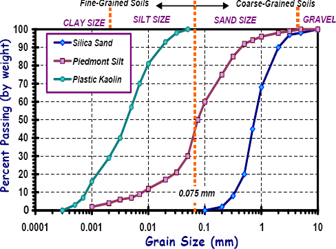
| Laboratory Determination | The grain size distribution of coarse particles is determined from a mechanical washed sieve analysis (AASHTO T 88, ASTM D 422). A representative sample is washed through a series of sieves (Figure 5-5). The amount retained on each sieve is collected, dried, and weighed to determine the percentage of material passing that sieve size. Figure 5-7 shows example grain size distributions for sand, silt, and clay soils as obtained from mechanical sieve and hydrometer (Table 5-20) tests. |
| Field Measurement | Not applicable. |
| Commentary | Obtaining a representative specimen is an important aspect of this test. When samples are dried for testing or "washing," it may be necessary to break up the soil clods. Care should be taken to avoid crushing of soft carbonate or sand particles. If the soil contains a substantial amount of fibrous organic materials, these may tend to plug the sieve openings during washing. The material settling over the sieve during washing should be constantly stirred to avoid plugging.Openings of fine mesh or fabric are easily distorted as a result of normal handling and use. They should be replaced often. A simple way to determine whether sieves should be replaced is the periodic examination of the stretch of the sieve fabric on its frame. The fabric should remain taut; if it sags, it has been distorted and should be replaced. A common cause of serious errors is the use of "dirty" sieves. Some soil particles, because of their shape, size or adhesion characteristics, have a tendency to be lodged in the sieve openings. |
| Typical Values | Typical particles size ranges for various soil textural categories are as follows (ASTM D 2487):
|
| Description | The grain size distribution is the percentage of soil finer than a given size vs. grain size. Fine particles are defined as smaller than 0.075 mm (0.0029 in, or No. 200 sieve). |
| Uses |
|
| Laboratory Determination | The grain size distribution of fine particles is determined from a hydrometer analysis (AASHTO T 88, ASTM D 422). Soil finer than 0.075 mm (0.0029 in or No. 200 sieve) is mixed with a dispersant and distilled water and placed in a special graduated cylinder in a state of liquid suspension (Figure 5-6). The specific gravity of the mixture is periodically measured using a calibrated hydrometer to determine the rate of settlement of soil particles. The relative size and percentage of fine particles are determined based on Stoke's law for settlement of idealized spherical particles. Figure 5-7 shows example grain size distributions for sand, silt, and clay soils as obtained from mechanical sieve (Table 5-19) and hydrometer tests. |
| Field Measurement | Not applicable. |
| Commentary | The principal value of the hydrometer analysis is in obtaining the clay fraction (percent finer than 0.002 mm). This is because the soil behavior for a cohesive soil depends principally on the type and percent of clay minerals, the geologic history of the deposit, and its water content, rather than on the distribution of particle sizes.
Repeatable results can be obtained when soils are largely composed of common mineral ingredients. Results can be distorted and erroneous when the composition of the soil is not taken into account to make corrections for the specific gravity of the specimen. Particle size of highly organic soils cannot be determined by the use of this method. |
| Typical Values |
|
Figure 5-5. Laboratory sieves for mechanical analysis of grain size distribution. Shown (right to left) are sieve Nos. 3/8-in. (9.5-mm), No. 10 (2.0-mm), No. 40 (250-µm) and No. 200 (750-µm) and example soil particle sizes including (right to left): medium gravel, fine gravel, medium-coarse sand, silt, and dry clay (kaolin).
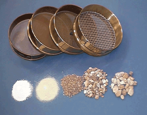
Figure 5-6. Soil hydrometer apparatus (http://www.ce.siue.edu/).
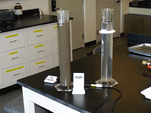
Figure 5-7. Representative grain size distributions for several soil types.
Plasticity
Plasticity describes the response of a soil to changes in moisture content. When adding water to a soil changes its consistency from hard and rigid to soft and pliable, the soil is said to exhibit plasticity. Clays can be very plastic, silts are only slightly plastic, and sands and gravels are non-plastic. For fine-grained soils, engineering behavior is often more closely correlated with plasticity than gradation. Plasticity is a key component of AASHTO and Unified soil classification systems (Section 4.7.2).
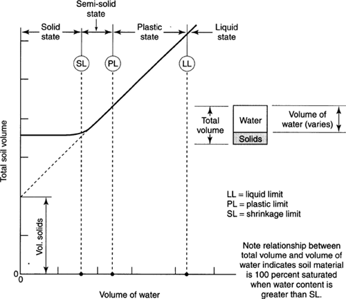
Soil plasticity is quantified in terms of Atterberg limits. As shown in Figure 5-8, the Atterberg limit values correspond to values of moisture content where the consistency of the soil changes as it is progressively dried from a slurry:
- The liquid limit (LL), which defines the transition between the liquid and plastic states.
- The plastic limit (PL), which defines the transition between the plastic and semi-solid states.
- The shrinkage limit (SL), which defines the transition between the semi-solid and solid states.
- Note in Figure 5-8 that the total volume of the soil changes as it is dried until the shrinkage limit is reached; drying below the shrinkage limit does not cause any additional volume change.
It is important to recognize that Atterberg limits are not fundamental material properties. Rather, they should be interpreted as index values determined from standardized test methods (Table 5-21).
Figure 5-8. Variation of total soil volume and consistency with change in water content for a fine-grained soil (from McCarthy, 2002).
| Description | Plasticity describes the response of a soil to changes in moisture content. Plasticity is quantified by Atterberg limits. |
| Uses in Pavements |
|
| Laboratory Determination | Atterberg limits are determined using test protocols described in AASHTO T89 (liquid limit), AASHTO T90 (plastic limit), AASHTO T 92 (shrinkage limit), ASTM D 4318 (liquid and plastic limits), and ASTM D 427 (shrinkage limit). A representative sample is taken of the portion of the soil passing the No. 40 sieve. The moisture content is varied to identify three stages of soil behavior in terms of consistency:
|
| Field Measurement | Not applicable. |
| Commentary | The Atterberg limits provide general indices of moisture content relative to the consistency and behavior of soils. The LL defines the lower boundary for the liquid state, while the PL defines the upper bound of the solid state. The difference is termed the plasticity index (PI = LL - PL). The liquidity index (LI), defined as LI = ( w - PL ) / PI, where w is the natural moisture content, is an indicator of soil consistency in its natural in-situ conditions.
It is important to recognize that Atterberg limits are approximate and empirical values. They were originally developed for agronomic purposes. Their widespread use by engineers has resulted in the development of a large number of empirical relationships for characterizing soils. Considering the somewhat subjective nature of the test procedure, Atterberg limits should only be performed by experienced technicians. Lack of experience and care can introduce serious errors in the test results.The optimum compaction moisture content is often in the vicinity of the plastic limit. |
| Typical Values | See Table 5-22. |
Figure 5-9. Liquid limit test device.
| Plasticity Index | Classification | Dry Strength | Visual-ManualIdentification of Dry Sample |
|---|---|---|---|
| 0 - 3 | Nonplastic | Very low | Falls apart easily |
| 3 - 15 | Slightly plastic | Slight | Easily crushed with fingers |
| 15 - 30 | Medium plastic | Medium | Difficult to crush with fingers |
| > 30 | Highly plastic | High | Impossible to crush with fingers |
5.3.3 Problem Soil Identification
Two special conditions that often need to be checked for natural subgrade soils are the potential for swelling clays (Table 5-23) or collapsible silts (Table 5-25).
Swelling soils exhibit large changes in soil volume with changes in soil moisture. The potential for volumetric swell of a soil depends on the amount of clay, its relative density, the compaction moisture and density, permeability, location of the water table, presence of vegetation and trees, and overburden stress. Swell potential also depends on the mineralogical composition of fine-grained soils. Montmorillonite (smectite) exhibits a high degree of swell potential, illite has negligible to moderate swell characteristics, and kaolinite exhibits almost none. A one-dimensional swell potential test is used to estimate the percent swell and swelling pressures developed by the swelling soils (Table 5-23).
Collapsible soils exhibit abrupt changes in strength at moisture contents approaching saturation. When dry or at low moisture content, collapsible soils give the appearance of a stable deposit. At high moisture contents, these soils collapse and undergo sudden decreases in volume. Collapsible soils are found most commonly in loess deposits, which are composed of windblown silts. Other collapsible deposits include residual soils formed as a result of the removal of organics by decomposition or the leaching of certain minerals (calcium carbonate). In both cases, disturbed samples obtained from these deposits will be classified as silt. Loess, unlike other non-cohesive soils, will stand on almost a vertical slope until saturated. It has a low relative density, a low unit weight, and a high void ratio. A one-dimensional collapse potential test is used to identify collapsible soils (Table 5-25).
| Description | Swelling is a large change in soil volume induced by changes in moisture content. |
| Uses in Pavements | Swelling subgrade soils can have a seriously detrimental effect on pavement performance. Swelling soils must be identified so that they can be either removed, stabilized, or accounted for in the pavement design. |
| Laboratory Determination | Swell potential is measured using either the AASHTO T 258 or ASTM D 4546 test protocols. The swell test is typically performed in a consolidation apparatus. The swell potential is determined by observing the swell of a laterally-confined specimen when it is surcharged and flooded. Alternatively, after the specimen is inundated, the height of the specimen is kept constant by adding loads. The vertical stress necessary to maintain zero volume change is the swelling pressure. |
| Field Measurement | Not applicable. |
| Commentary | This test can be performed on undisturbed, remolded, or compacted specimens. If the soil structure is not confined (i.e., a bridge abutment) such that swelling may occur laterally and vertically, triaxial tests can be used to determine three dimensional swell characteristics. |
| Typical Values | Swell potential can be estimated in terms of soil physical properties; see Table 5-24. |
| % finer than 0.001mm | Atterberg Limits | Probable expansion, % total volume change* | Potential for expansion | |
|---|---|---|---|---|
| PI (%) | SL (%) | |||
| > 28 | > 35 | < 11 | > 30 | Very high |
| 20-31 | 25-41 | 7-12 | 20-30 | High |
| 13-23 | 15-28 | 10-16 | 10-30 | Medium |
| < 15 | < 18 | >15 | < 10 | Low |
* Based on a loading of 6.9 kPa (1 psi).
| Description | Collapsible soils exhibit large decreases in strength at moisture contents approaching saturation, resulting in a collapse of the soil skeleton and large decreases in soil volume. |
| Uses in Pavements | Collapsible subgrade soils can have a seriously detrimental effect on pavement performance. Collapsible soils must be identified so that they can be either removed, stabilized, or accounted for in the pavement design. |
| Laboratory Determination | Collapse potential is measured using the ASTM D 5333 test protocol. The collapse potential of suspected soils is determined by placing an undisturbed, compacted, or remolded specimen in a consolidometer ring. A load is applied and the soil is saturated to measure the magnitude of the vertical displacement. |
| Field Measurement | Not applicable. |
| Commentary | The collapse during wetting occurs due to the destruction of clay binding, which provides the original strength of these soils. Remolding and compacting may also destroy the original structure. |
| Typical Values | None available. |
5.3.4 Other Aggregate Tests
There is a wide range of other mechanical property tests that are performed to measure the quality and durability of aggregates used as subbases and bases in pavement systems and as constituents of asphalt and Portland cement concrete. These other aggregate tests are summarized in Table 5-26. Additional information can be found in The Aggregate Handbook published by the National Stone Association (Barksdale, 2000). A recent NCHRP study provides additional useful information on performance-related tests of aggregates used in unbound pavement layers (Saeed, Hall, and Barker, 2001).
| Property | Use | AASHTO Specification | ASTM Specification |
|---|---|---|---|
| Fine Aggregate Quality | |||
| Sand Equivalent | Measure of the relative proportion of plastic fines and dust to sand size particles in material passing the No. 4 sieve | T 176 | D 2419 |
| Fine Aggregate angularity (also termed Uncompacted Air Voids) | Index property for fine aggregate internal friction in Superpave asphalt mix design method | T 304 | C 1252 |
| Coarse Aggregate Quality | |||
| Coarse Aggregate Angularity | Index property for coarse aggregate internal friction in Superpave asphalt mix design method | D 5821 | |
| Flat, Elongated Particles | Index property for particle shape in Superpave asphalt mix design method | D 4791 | |
| General Aggregate Quality | |||
| Absorption | Percentage of water absorbed into permeable voids | T 84/T 85 | C 127/C 128 |
| Particle Index | Index test for particle shape | D 3398 | |
| Los Angeles degradation | Measure of coarse aggregate resistance to degradation by abrasion and impact | T 96 | C 131 or C 535 |
| Soundness | Measure of aggregate resistance to weathering in concrete and other applications | T 104 | C 88 |
| Durability | Index of aggregate durability | T 210 | D 3744 |
| Expansion | Index of aggregate suitability | D 4792 | |
| Deleterious Materials | Describes presence of contaminants like shale, clay lumps, wood, and organic material | T 112 | C 142 |
| << Previous | Contents | Next >> |