


| Project Name | Belvedere Park, Highway Cap Park Project |
|---|---|
| Location | Los Angeles, California |
| Project Sponsor / Borrower | City of Los Angeles, California |
| Program Areas | |
| Value Capture Techniques | Asset Recycling & Right-of-Way Use Agreements |
| Mode | Bridge (Highway Capping Project; Park) |
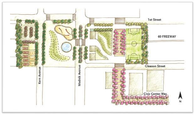
| Description | The Belvedere Park capping project is a proposed plan to cover a freeway built over 50 years ago, which will include cutting the 31-acre park into two parts. If approved, the capping project would reconnect the north and south parts of the park. The project is part of a plan devoted to developing the Metro Gold Line Station corridor in East Los Angeles, California. The Los Angeles County plan suggests capping a three-block section above the 60 Freeway at Mednick Avenue with an elevated platform featuring playing fields and ball courts. The project would create new public space, improve pedestrian, and bike access, and improve accessibility to the metro station. Belvedere Park is the largest park in the unincorporated East part of Los Angeles, California. The Park features playing fields, an Olympic-sized pool, skateboard park, lake, and amphitheater. It is accessible from the pedestrian bridge or from the residential streets on its east and north sides. It has designated sports facilities, including space for softball, baseball, soccer, basketball, and tennis. In addition to the lights for the sports spaces, there are streetlights around the perimeter of the park and along the pathways. The Park includes three park offices, one community building, one gymnasium, two multi-purpose rooms, and a computer lab to support program activities. There are no bike racks or spaces for formal bike parking at the park. Historically, Belvedere Park was one park, but was divided when the freeway system was constructed through East Los Angeles in the 1960s. The construction of the Pomona Freeway bisected Belvedere Park, reducing available open space and dividing the park. The Park has since functioned as two different parks. Creating a freeway overpass park to connect Civic Center Park and Belvedere Park could significantly add to overall green space and expand the connection between the two existing green spaces currently linked only by a narrow pedestrian bridge. A potentially expensive expansion, it is expected to increase overall green space in other parts of the County and improve nonmotorized connections between the neighborhoods to the north and south of the freeway. The plan has not been approved nor funded at this time. |
| Cost | TBD |
| Funding Sources | TBD |
| Project Delivery / Contract Method | TBD |
| Private Partner | TBD |
| Project Advisors / Consultants | TBD |
| Lenders | TBD |
| Duration / Status | Propose; The project is in early stage |
| Financial Status / Financial Performance | There are no budget or funding for the project at this time |
| Innovations |
|
| Related Links / Articles | |
| Contacts | Land Development Coordinating Center (213) 974-6411 zoningldcc@planning.lacounty.gov Norma E. García-Gonzalez Director, County of Los Angeles Department of Parks and Recreation |