
|
WASHINGTON, D.C. · (202) 366-0180
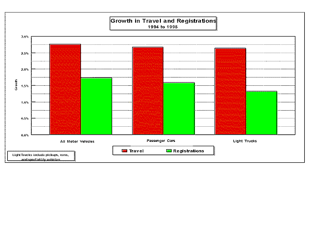
Vehicle Miles of Travel Grew at 2.76% in 1995
Vehicle registrations grew at annual rate of 1.73 percent from
1994 to 1995. At the same time, vehicle miles traveled (VMT) grew
at a 2.76-percent rate for all vehicles. The components of the
growth in travel are a 2.75-percent increase in rural VMT and
a 2.78-percent increase in urban travel.
Passenger car travel grew at a 2.67-percent pace for all roadways,
increasing 2.51 percent in rural areas and 2.75 percent in urban
areas. This compares with passenger car registration growth of
1.60 percent from 1994 to 1995. Average miles per vehicle for
passenger cars was 11,329 in 1995, representing a 1.06-percent
growth from 1994.
Other two-axle, four-tire vehicle average annual miles in 1995
was 11,865. This is an increase of 1.30 percent from 1994. Other
two-axle, four-tire vehicles are defined as those vehicles with
only two axles and four tires which are not passenger cars. These
include pickup trucks, vans, and sport/utility vehicles and are
often referred to as light trucks. Light truck registrations increased
1.32 percent in 1995, while travel grew at a 2.64-percent rate.
This information and other related data are included in the 1995
table VM-1 from the annual Highway Statistics publication
recently released by the Office of Highway Information Management.
To receive a copy of Highway Statistics 1995, call (202)
366-0160. For more information on these data, contact William
Grush at william.grush@fhwa.dot.gov or call (202) 3665052.
|
|
|
|
Highway Statistics Brochure
In September, FHWA's Office of Highway Information Management
released a brochure titled "FHWA's Statistical Programs--A
Customer's Guide to Using Highway Statistics".
This brochure gives general background on FHWA's statistical programs,
provides examples of important uses of highway information, and
outlines directions for FHWA's future statistical efforts. The
brochure is targeted broadly at both the transportation decisionmaker
as well as the transportation information professional.
The brochure results primarily from FHWA's Highway Statistics
Steering Committee, which is a group of Federal, State and other
officials providing advice and feedback to FHWA on FHWA's statistical
programs.
Copies of the brochure are being made available through FHWA's
Regional offices, or may be obtained by calling (202) 366-0180.
Heaviest Truck Traffic Routes on the Interstate
Based on 1994 Highway Performance Monitoring System (HPMS) data, the heaviest truck traffic routes on the Interstate System are in or near large urbanized areas. The chart shows the heaviest truck volume segments among the sample sections. The percent trucks range from a low of 9 percent on I-75 in Atlanta to a high of 41 percent on I-30 in Arkansas. NOTE: These segments may not represent the highest percent trucks, highest total annual average daily traffic (AADT), or highest truck AADT because data are obtained from randomly sampled Interstate sections.
|
|
|
|
|
|
|
|
| ChicagoNorthwestern, IN | 90 | 275,498 | 15% | 41,324 |
|
| ChicagoNorthwestern, IN | 55 | 137,291 | 26% | 35,695 |
|
| ChicagoNorthwestern, IN | 290 | 162,794 | 20% | 32,558 |
|
| ChicagoNorthwestern, IN | 94 | 110,845 | 29% | 32,145 |
|
| ChicagoNorthwestern, IN | 80 | 111,771 | 26% | 29,060 |
|
| New YorkNortheastern, NJ | 95 | 272,903 | 14% | 38,206 |
|
| Los Angeles | 15 | 139,500 | 26% | 36,270 |
|
| Los Angeles | 710 | 203,900 | 14% | 28,546 |
|
| New Orleans | 10 | 173,789 | 19% | 33,019 |
|
| Indianapolis | 70 | 164,335 | 18% | 29,580 |
|
| ---------------------------- 4 | 95 | 134,300 | 22% | 29,546 |
|
| --------------------------- 4 | 30 | 68,697 | 41% | 28,165 |
|
| MinneapolisSt. Paul | 35W | 190,000 | 15% | 28,500 |
|
| MinneapolisSt. Paul | 94 | 176,000 | 15% | 26,400 |
|
| Detroit | 75 | 218,000 | 13% | 28,340 |
|
| Detroit | 96 | 206,000 | 13% | 26,780 |
|
| Washington (DCMDVA) | 95 | 250,000 | 11% | 27,500 |
|
| Washington (DCMDVA) | 495 | 211,525 | 12% | 25,383 |
|
| Greensboro | 85 | 118,900 | 23% | 27,347 |
|
| Atlanta | 75 | 303,000 | 9% | 27,270 |
|
| Louisville | 65 | 103,000 | 26% | 26,780 |
|
| Tucson | 10 | 98,175 | 27% | 26,507 |
|
| Phoenix | 10 | 202,407 | 13% | 26,312 |
|
| San FranciscoOakland | 880 | 184,500 | 14% | 25,830 |
|
| Charlotte | 85 | 116,700 | 22% | 25,674 |
|
| Baton Rouge | 10 | 126,651 | 20% | 25,330 |
|
| ¹ Routes on the Interstate system with truck traffic of 25,000+ AADT. | |||||
| ² "Trucks" includes vehicles classified as buses, six-tire trucks and above. Percent trucks are derived from classification counts conducted on sampled sections or similar roadway sections determined to have similar truck travel distributions. | |||||
| 3 Calculated value. | |||||
| 4 Non-urbanized section. | |||||
For additional information, contact Beverly Harrison, HPM-20, at (202) 366-4048.
Office of Highway Information Management (OHIM) Exhibits at AASHTO Technology Show
FHWA's OHIM featured two visual displays, an Internet Demonstration, and a sampling of its key products at the AASHTO Transportation Technology Fair. The Fair was held in conjunction with the 82nd Annual AASHTO Meeting in Buffalo, New York from October 5 to 8.
This year's Fair was 30 percent larger than last year's, with
82 exhibitors from California to Massachusetts, displaying their
technologies in 128 booths. Eight State Departments of Transportation
also had exhibits with their newest technology. Visual displays
on FHWA's Highway Performance Monitoring System and FHWA's general
statistical programs were part of the FHWA's section of the Technology
Fair. In addition, a hands-on computer demonstration enabled
Fair participants to access Highway Statistics via the
Internet. Copies of OHIM's most popular publications were made
available to participants. FHWA's OHIM Director, Gary E. Maring,
attended the Technology Fair, discussed information issues and
answered participant questions.
Highway Statistics 1995 Being Printed
Highway Statistics 1995 has gone to the printer and should
be distributed before the end of the year. This report comprises
data provided by State and local governments as part of an ongoing
cooperative effort to assemble national statistics on highways
for planning and other purposes.
Some of the more significant changes that have been made in this
issue are:
DRIVER LICENSES: Tables DL-1A
and DL-1B have been combined into one table,DL-1C.
A column showing the ratio of licensed drivers to registered
private and commercial vehicles has been added and the map showing
same has been eliminated.
FINANCE:
Table MF-205, which shows State tax rates on motor fuel
for 1981-1995, has been added. Table FA-5a has been renamed FA-21
(Federal equivalency of SF-21 and LGF21).
ROADWAY EXTENT, CHARACTERISTICS, AND PERFORMANCE: Table HM63 has been changed to remove all references to "Pavement Condition" and to eliminate all International Roughness Index (IRI) data. This table now contains only Present Serviceability Rating (PSR) data for the three functional systems for which IRI data are not required and routinely reported--Rural Major Collectors, Urban Minor Arterials, and Urban Collectors. In addition, the verbal descriptors-good, fair, poor,
etc.--have been deleted with the determination of what constitutes
a good pavement based upon PSR data left to the user. Numerical
ranges have not been changed to facilitate multiyear comparison
of the data. IRI data for the other functional systems are included
in Table HM64, which is unchanged from previous issues.
As with the PSR data included in Table HM63, the determination
of what constitutes a good or other pavement rating based upon
IRI data is left to the user to decide.
We plan to support access to Highway Statistics for 1994
and 1995 through the Internet as a hotlink through Federal Highway
Administration, Office of Highway Information Management (OHIM):
To get on our mailing list, please call OHIM at (202) 366-0160.
For information on the content, please contact Mary K. Teets
at (202) 366-9211.
Highway Statistics Summary to 1995
The historical data is being analyzed by the staff of the Office
of Highway Information Management (OHIM) and will be distributed
by June 1997 in paper format and also electronically.
The Summary to 1945 was the first in this series of publications.
This document is a summary of the annual series of Highway
Statistics that brings to the user a comprehensive statistical
review of highway development in the United States through 1995.
The most widely used data has been chosen for this series.
For copies, please call OHIM at (202) 366-0160. For information on the content, please contact Mary K. Teets at (202) 366-9211.
Improved Pavement Condition Data
The FHWA, in cooperation with the States, is involved in a study
to establish more uniform and higher quality data on pavement
condition for use in State pavement management systems for developing
investment analyses, predicting pavement performance, and making
network level pavement decisions. The study consists of four
phases:
1. Pilot Survey: The range of data collection
practices used by States was investigated in an initial survey
of 10 States. It was found that condition measurements are uniform
within a given State, but that the procedures and distresses used
to measure pavement condition vary considerably among the States.
2. Nationwide Survey: In this phase the initial
pilot survey was expanded to include the remaining States in the
Nation. The expanded survey indicated that the majority of States
measure roughness, rutting, faulting, and cracking for network
level pavement management and that there is a need to develop
nationwide protocols to provide better consistency among the States
in evaluating pavement condition.
3. Development of Protocols: In this phase, a contractor
is currently developing the protocols based upon the information
collected in phase 2. The approach to developing the protocols
includes research, engineering analysis, statistical analysis,
and consensus-seeking among the States. At the same time, FHWA
is promoting consensus among the national organizations such as
the American Society for Testing and Materials (ASTM), American
Association of State Highway and Transportation Officicials (AASHTO),
Strategic Highway Research Program--Long-Range Pavement Performance
(SHRP LTPP), Road Profiler User Group (RPUG), and the 50 States.
4. Implementation of Protocols: Upon completion
of the development phase, the protocols will be turned over to
the AASHTO Joint Task Force on Pavements to be adopted as an AASHTO
Guide for use in network level pavement management. The FHWA will
assist AASHTO efforts to promote and facilitate the adoption,
implementation, and use of the protocols nationwide. The success
of this phase will depend upon the flexibility of the protocols
and the willingness of the States to participate. To the extent
possible, the protocols are being designed to facilitate continued
use of existing equipment and historical data.
The development of protocols is intended to support consistency
of data across time and space, to identify condition measurements
that are cost-effective for network-level decision-making, and
to provide reliable means to report and summarize condition measurements.
The implementation of these protocols can be expected to enhance
data quality, streamline State pavement data collection operations,
and support the trend to automated data collection by providing
a technology focus. These last two impacts are expected to lead
to improved State business processes and consequent cost savings.
For more information on the engineering aspects of these protocols,
contact Frank Botelho at (202) 366-1336. Contact Jim Getzewich
at (202) 366-0175 for HPMS related- information.
Highway Performance Monitoring System (HPMS) Steering Committee Tackles Six Issues
The HPMS Steering Committee met for the third time in August 1996
in Arlington, VA. The two objectives of the meeting were to review
progress on the six priority issues since the last meeting and
to set necessary changes in motion.
1. HPMS Strategic Review
FHWA presented the preliminary issues and concepts paper called
for at the last meeting. FHWA has decided to undertake the next
steps in the HPMS Strategic Reassessment to include the following:
(1) By December 31, prepare a white paper outlining possible HPMS
alternatives under future legislation. Include alternatives such
as a concentration of the Federal role on monitoring the NHS;
national level sampling of data for HPMS purposes; greater reliance
on other data sources, such as management systems and data available
through ITS deployments; and making marginal improvements to the
status quo, among others;
(2) By December 31, publish a Federal Register Notice announcing
the HPMS strategic reassessment;
(3) By December 31, put contractor support in place to study
critical HPMS issues and to develop an outreach process;
(4) Conduct an outreach workshop by July 31.
2. Vehicle Miles of Travel (VMT) Estimating and Forecasting
The Committee recommended that FHWA continue its case studies
of issues and problems associated with traffic counting and forecasting
in urbanized areas. FHWA will develop a comprehensive report
of its findings. On a more long-term basis, FHWA will undertake
the development of guidelines for good practice in the counting
of traffic in urbanized areas.
3. HPMS Training
FHWA completed an initial assessment of possible training program
structures and recommended a computer-aided instructional program
to the Committee.
4. Measuring Congestion
FHWA agreed to develop an analysis of the existing HPMS congestion-related data. The analyses will be completed on an aggregate basis, not highlighting either individual States or urbanized areas, and will be broadly disseminated to the transportation community. FHWA's Congestion Management Coordination Group (CMCG) will assume the responsibility for developing longer-range congestion-related projects and activities.
5. Truth in Data (Appropriate Uses)
FHWA agreed to include the paper as circulated to the Committee
in Highway Statistics 1995. FHWA will prepare a shorter
version of the truth-in-data paper to be disseminated through
venues other than Highway Statistics. In addition, FHWA
agreed to modify the tables in Highway Statistics 1995
to address some of the criticisms that have been received on the
presentation of IRI and PSR data. Finally, in the interest of
improving communications with HPMS data providers and users on
the uses of HPMS data, FHWA agreed to prepare a paper on the uses
of HPMS data in the analytical modeling process.
6. HPMS Refinements (Short Term)
Members of the Committee agreed to highlight redundant or duplicative
HPMS data items or subitems; items or subitems that are perceived
as having too many subcategories; and items or subitems that are
not used in normal practice. FHWA will investigate the impact
of deleting less significant data items from the HPMS modeling
process. The information will be used to determine if there are
any areas where the HPMS data burden can be reduced. In addition,
FHWA will further investigate potential changes to the HPMS sampling
program to determine if the rural sample precision levels, and
hence the sample size, can be reduced and if the growth in the
number of sample sections that results from sample subdivisions
can be reduced without damaging the validity of the sample and
quality of the data.
Next meeting: A fourth meeting of the HPMS Steering Committee
will be convened before the end of May 1997, although no date
has yet been set. For more information, contact Jim Getzewich
at (202) 366-0175.
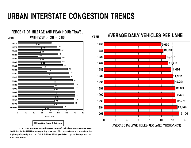
Urban Interstate Congestion Trends
The peak-hour volume-service flow (v/sf) ratio has been used for
many years as a measure of the severity of recurring congestion.
For urban Interstate highways, this measure reached 69 percent
in 1989, and remained within 1 percent of that level until
1995. This value may represent a practical maximum for this measure,
showing that about 70 percent of urban Interstate highway sections
were operating at or near saturated flow during the peak hour
of travel.
What happens when the peak-hour traffic volume approaches or reaches
saturation? The traveler makes changes to adapt to the situation,
such as traveling at another time of day, perhaps an hour earlier
or later than before, or taking transit, or changing job location.
The employer may change the location of the job because of congestion;
both the employee and employer may take other steps to minimize
travel during the peak hour.
Thus, a leveling off of the v/sf ratio does not necessarily
indicate a leveling-off of congestion. It may mean that the severity
of congestion has reached a peak, and that the duration of congestion
is increasing. Congestion may occur for 4 hours a day, or 6 hours.
The v/sf ratio, after all, is limited to a maximum
of about 1.0 for any individual section of highway. For nearly
70 percent of peak-hour travel to occur under congested conditions
means that much of the peak hour travel is occurring at or near
a v/sf ratio of 1.0. It says nothing about how much travel
at other hours is occurring under congested conditions.
The major decrease in the percent of travel that appears for the
year 1995 is an artifact of the change in capacity calculation
procedures based on the Highway Capacity Manual (HCM).
A revised HCM was issued in 1994, and subsequent calculations
of capacity have been based on the revised procedures. The change
in procedures was based on research that showed that drivers were
willing to follow each other more closely and at higher speeds
than previously. Of course, this change in driving habits occurred
over a period of years, but the change in procedure occurred abruptly.
This caused the break in the trend that invalidates comparisons
between 1995 measures of capacity and previous years.
No doubt our freeway system, especially the Interstate System,
will accommodate more vehicles per lane per hour than was the
case 20 years ago because of the change in driving habits. Does
this suggest a decrease in congestion? Not likely. It does show
a willingness to take greater risks in driving, or improvements
in driver ability, or improvements in vehicle braking systems--perhaps
all three.
Despite the discontinuity in the v/sf ratio figure for 1995, note that another measure unaffected by the HCM change, travel per lane-mile on urban Interstate highways, continues to increase. This is a measure of travel intensity throughout the day. To improve our understanding of congestion, one must increasingly look for measures in addition to the peak-hour v/sf ratio. The Federal Highway Administration's Congestion Management Coordinating Group is currently considering a number of other measures such as delay and travel time. Another need is to look at the issue of non-recurring congestion, which is not measurable by the peak hour v/sf ratio, and which many estimate is as large a problem as recurring congestion.
The Texas Transportation Institute (TTI) has developed time series
estimates of the cost of congestion for 50 cities in the Nation.
For 1988, this cost was reported to be $34 billion; for 1993,
this cost was reported to be $50 billion. (See Urban Roadway
Congestion--1982 to 1993, November 1996, by David L. Schrank
and Timothy J. Lomax.) This study indicates that congestion costs
continue to increase significantly. Note that the TTI report
does not use capacity calculations, but bases its estimates of
the cost of congestion on traffic volume values per lane.
For additional information, contact Cliff Comeau, HPP-20, at (202) 366-4051 or Beverly Harrison, HPM-20, at
(202) 366-4048.
Second National Conference on Women's Travel Issues Held
Transportation impacts of welfare reform; women's continuing role
as the primary care-giver for children and for aging parents;
and women's economic position, mobility, and accessibility to
jobs were among the topics discussed at the second National Conference
on Women's Travel Issues held in Baltimore, Maryland on October
23-26, 1996. The first conference was held in 1978.
Dr. Sandra Rosenbloom, Director of the Drachman Institute at the
University of Arizona, and Dr. Shirley Byron, Professor of
Planning, Morgan State University, served as co-chairs of the
conference. The conference was sponsored by FHWA Office of
Policy and the Women and Planning Division of the American Planning
Association.
During the Conference, the topics of safety and security came up repeatedly. Women rate security as their highest travel concern, compared to men who say that congestion is the most problematic travel issue. Concerns about security affect private- vehicle, public-transit, and pedestrian modes of travel and bring up several important questions. In the ITS arena, will in-vehicle navigation systems be welcomed by women, or have they been designed to select "shortest path," instead of "safest path"? Are women's concerns about security being addressed in the design and development of these systems? Can transit systems attract more riders by developing flexible route systems that permit people to get to and from their activities without waiting at bus stops or walking several blocks in undesirable locations? Can transit or paratransit systems do a better job to assist women who may be low-paid and work evening and late night shifts, such as those in nursing and janitorial services.
Another topic of major concern was women and the economy. Women
are nearing the peak of labor force participation, yet women's
wages still are only 75 percent that of men. Women, on average,
have shorter travel times to work than men, but Census data show
that minority women who make "reverse commutes" tend
to have longer commutes, despite low incomes and needing to combine
work with child-care responsibilities. The discussion included
that information technology may impact women differently than
men; for example, telecommuting jobs for women may be more like
"piece work," compared with highly professional or technical
jobs for men.
There was consensus that for these needs and concerns to be addressed,
women must be part of the transportation policy decision-making
process. These issues must be discussed in the public participation/community
involvement process in transportation planning.
Proceedings, which will include the papers and the research agenda, are anticipated to be available by Spring 1997 from FHWA. For more information, please call Elaine Murakami at 202-366-6971, or
e-mail at Elaine.Murakami@fhwa.dot.gov.
Back to Reports