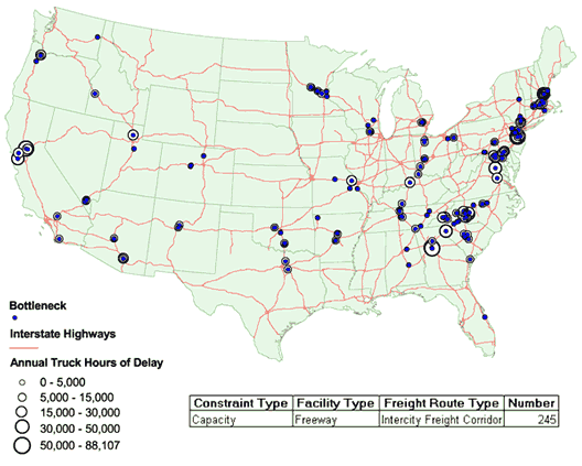
Figure D.1 Capacity Bottlenecks on Freeways Used As Intercity Truck Corridors
HPMS Sample Sections Only
| Route Number | Bottleneck Location | No. of Lanes | All Vehicles-2004 | All Trucks-2004 | |||
|---|---|---|---|---|---|---|---|
| AADT | AADTT | Percent of All Vehicles | Annual Hours of Delay All Trucks | Annual Hours of Delay All Trucks (Expanded) | |||
| 85 | Mecklenburg, North Carolina | 4 | 94,761 | 18,005 | 19% | 212,021 | 260,786 |
| 75 | Henry, Georgia | 6 | 133,850 | 34,801 | 26% | 148,845 | 266,134 |
| 75 | Henry, Georgia | 6 | 137,399 | 35,724 | 26% | 148,056 | 180,036 |
| 80 | Yolo, California | 6 | 133,207 | 11,989 | 9% | 85,317 | 194,437 |
| 93 | Rockingham, New Hampshire | 4 | 98,403 | 11,808 | 12% | 67,024 | 67,024 |
| 580 | Alameda, California | 8 | 158,093 | 30,038 | 19% | 64,881 | 115,684 |
| 95 | Mercer, New Jersey | 6 | 110,159 | 19,829 | 18% | 60,228 | 63,300 |
| 77 | Iredell, North Carolina | 4 | 76,834 | 14,598 | 19% | 57,778 | 165,880 |
| IS95 | Stafford, Virginia | 6 | 124,787 | 14,974 | 12% | 55,103 | 137,206 |
| 10 | Pima, Arizona | 4 | 82,344 | 31,291 | 38% | 50,247 | 50,247 |
| 95 | Harford, Maryland | 8 | 138,995 | 29,189 | 21% | 49,414 | 49,414 |
| 15 | Weber, Utah | 4 | 92,058 | 23,015 | 25% | 48,088 | 48,088 |
| 93 | Rockingham, New Hampshire | 4 | 84,369 | 10,124 | 12% | 46,136 | 46,136 |
| 95 | Mercer, New Jersey | 6 | 109,359 | 19,685 | 18% | 43,941 | 46,182 |
| 95 | Harford, Maryland | 6 | 106,982 | 22,466 | 21% | 42,756 | 94,704 |
| 85 | Rowan, North Carolina | 4 | 64,715 | 11,649 | 18% | 39,756 | 68,778 |
| 78 | Hunterdon, New Jersey | 6 | 108,031 | 19,446 | 18% | 35,923 | 37,755 |
| 85 | Anderson, South Carolina | 4 | 42,763 | 11,974 | 28% | 29,161 | 78,211 |
| 95 | Baltimore, Maryland | 8 | 149,757 | 22,464 | 15% | 28,182 | 73,527 |
| 78 | Hunterdon, New Jersey | 6 | 98,785 | 17,781 | 18% | 25,143 | 25,143 |
| 93 | Rockingham, New Hampshire | 4 | 94,043 | 11,285 | 12% | 24,545 | 24,545 |
| 95 | Middlesex, New Jersey | 6 | 115,783 | 20,841 | 18% | 24,303 | 25,542 |
| 85 | Rowan, North Carolina | 4 | 61,532 | 11,691 | 19% | 24,190 | 41,849 |
| 87I | Orange, New York | 6 | 94,696 | 17,045 | 18% | 23,466 | 23,466 |
| 85 | Rowan, North Carolina | 4 | 66,678 | 16,003 | 24% | 23,430 | 121,064 |
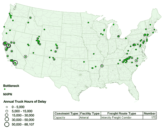
Figure D.2 Capacity Bottlenecks on Arterials Used As Intercity Truck Corridors
HPMS Sample Sections Only
| Route Number | Bottleneck Location | No. of Lanes | All Vehicles-2004 | All Trucks-2004 | |||
|---|---|---|---|---|---|---|---|
| AADT | AADTT | Percent of All Vehicles | Annual Hours of Delay All Trucks | Annual Hours of Delay All Trucks (Expanded) | |||
| 99 | San Joaquin, California | 4 | 109,083 | 21,817 | 20% | 617,667 | 975,913 |
| 99 | San Joaquin, California | 4 | 113,123 | 28,281 | 25% | 123,662 | 226,301 |
| 101 | Sonoma, California | 4 | 108,493 | 7,595 | 7% | 77,816 | 199,132 |
| 37 | Solano, California | 2 | 32,822 | 5,580 | 17% | 71,618 | 124,258 |
| 57 | Los Angeles, California | 10 | 216,303 | 25,956 | 12% | 65,984 | 65,984 |
| 61 | DeSoto, Mississippi | 2 | 34,977 | 6,646 | 19% | 58,088 | 142,780 |
| 71 | Riverside, California | 2 | 46,680 | 5,135 | 11% | 41,448 | 83,476 |
| U.S. 59 | Montgomery, Texas | 4 | 92,945 | 10,224 | 11% | 40,193 | 40,193 |
| 99 | San Joaquin, California | 4 | 82,824 | 15,737 | 19% | 37,224 | 68,120 |
| 101 | Marin, California | 4 | 95,481 | 4,774 | 5% | 33,241 | 85,065 |
| 95 | Clark, Nevada | 6 | 207,515 | 6,225 | 3% | 27,668 | 27,668 |
| 12 | Napa, California | 2 | 33,518 | 2,681 | 8% | 16,952 | 57,399 |
| 24 | Harnett, North Carolina | 2 | 19,665 | 2,753 | 14% | 16,608 | 46,071 |
| 74 | Orange, California | 2 | 16,665 | 1,667 | 10% | 15,374 | 77,424 |
| 101 | San Benito, California | 4 | 61,854 | 9,278 | 15% | 15,064 | 16,857 |
| 28 | Hampshire, West Virginia | 2 | 6,067 | 849 | 14% | 14,524 | 96,335 |
| 37 | Sonoma, California | 2 | 32,557 | 2,930 | 9% | 13,453 | 23,341 |
| 99 | Fresno, California | 6 | 87,602 | 21,024 | 24% | 12,448 | 31,854 |
| 101 | Monterey, California | 4 | 77,451 | 12,392 | 16% | 11,364 | 20,795 |
| 19E | Yancey, North Carolina | 2 | 13,792 | 1,931 | 14% | 10,789 | 29,648 |
| 395 | Douglas, Nevada | 2 | 8,202 | 1,312 | 16% | 10,750 | 23,199 |
| 421 | Wilkes, North Carolina | 2 | 28,309 | 3,963 | 14% | 10,612 | 35,318 |
| NJTPK | Gloucester, New Jersey | 4 | 54,341 | 8,151 | 15% | 10,306 | 10,306 |
| 23 | Washtenaw, Mississippi | 4 | 66,980 | 6,698 | 10% | 10,277 | 10,277 |
| 101 | San Luis Obispo, California | 4 | 68,686 | 6,182 | 9% | 10,098 | 11,300 |
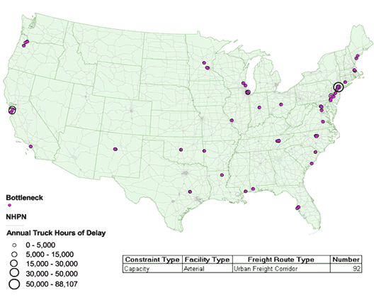
Figure D.3 Capacity Bottlenecks on Arterials Used As Urban Truck Corridors
HPMS Sample Sections Only
| Route Number | Bottleneck Location | No. of Lanes | All Vehicles-2004 | All Trucks-2004 | |||
|---|---|---|---|---|---|---|---|
| AADT | AADTT | Percent of All Vehicles | Annual Hours of Delay All Trucks | Annual Hours of Delay All Trucks (Expanded) | |||
| NJ 17 | Bergen, New Jersey | 6 | 129,291 | 15,515 | 12% | 115,448 | 639,235 |
| SH 183 | Tarrant, Texas | 6 | 154,770 | 10,834 | 7% | 50,368 | 126,928 |
| SL 8 | Harris, Texas | 6 | 163,410 | 3,268 | 2% | 45,480 | 146,173 |
| SH 183 | Tarrant, Texas | 6 | 144,450 | 10,112 | 7% | 35,104 | 88,462 |
| SH 183 | Tarrant, Texas | 6 | 147,461 | 10,322 | 7% | 27,426 | 69,113 |
| 237 | Santa Clara, California | 6 | 126,247 | 8,837 | 7% | 24,614 | 24,614 |
| SH 183 | Tarrant, Texas | 6 | 147,462 | 10,322 | 7% | 20,305 | 51,167 |
| 85 | Santa Clara, California | 6 | 144,783 | 2,896 | 2% | 17,341 | 17,341 |
| U.S. 202 | Montgomery, Pennsylvania | 4 | 123,415 | 8,639 | 7% | 7,743 | 28,532 |
| SH 183 | Tarrant, Texas | 6 | 159,885 | 9,593 | 6% | 6,968 | 17,559 |
| SH 183 | Tarrant, Texas | 6 | 159,886 | 9,593 | 6% | 6,913 | 17,420 |
| NJ 4 | Bergen, New Jersey | 6 | 100,247 | 12,030 | 12% | 6,848 | 109,700 |
| U.S. 30 | Camden, New Jersey | 4 | 82,920 | 8,292 | 10% | 5,956 | 29,422 |
| NJ 4 | Bergen, New Jersey | 6 | 114,035 | 13,684 | 12% | 4,964 | 27,486 |
| NJ 4 | Bergen, New Jersey | 5 | 100,247 | 12,030 | 12% | 3,836 | 61,449 |
| SR 60 | Hillsborough, Florida | 8 | 180,798 | 12,656 | 7% | 3,833 | 8,106 |
| 31 | Hamilton, Indiana | 4 | 73,229 | 13,181 | 18% | 3,791 | 3,791 |
| U.S. 1 | 12086 | 6 | 92,612 | 6,483 | 7% | 3,722 | 15,952 |
| SH 114 | Tarrant, Texas | 6 | 121,989 | 7,319 | 6% | 3,386 | 8,534 |
| 22 | Los Angeles, California | 4 | 97,972 | 2,939 | 3% | 3,177 | 3,177 |
| U.S. 22 | Union, New Jersey | 5 | 95,560 | 11,467 | 12% | 2,903 | 46,497 |
| DEL141 | New Castle, Delaware | 4 | 78,532 | 6,283 | 8% | 2,328 | 2,328 |
| 1 | Wake, North Carolina | 4 | 46,843 | 3,747 | 8% | 2,284 | 4,609 |
| 165 | Ouachita, Louisiana | 4 | 67,187 | 16,797 | 25% | 2,140 | 2,140 |
| SR 60 | Hillsborough, Florida | 8 | 146,482 | 8,789 | 6% | 2,108 | 4,458 |
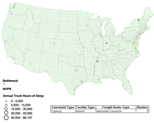
Figure D.4 Capacity Bottlenecks on Arterials Used As Intermodal Connectors (Code 1-2-3)
HPMS Sample Sections Only
| Route Number | Bottleneck Location | No. of Lanes | All Vehicles-2004 | All Trucks-2004 | |||
|---|---|---|---|---|---|---|---|
| AADT | AADTT | Percent of All Vehicles | Annual Hours of Delay All Trucks | Annual Hours of Delay All Trucks (Expanded) | |||
| 36 | Marion, Indiana | 4 | 68,833 | 5,507 | 8% | 402 | 1,440 |
| Shelby, Tennessee | 4 | 69,316 | 2,773 | 4% | 331 | 639 | |
| 2 | Chittenden, Vermont | 4 | 61,963 | 3,718 | 6% | 281 | 281 |
| 2 | Chittenden, Vermont | 4 | 49,694 | 2,982 | 6% | 144 | 144 |
| - | Shelby, Tennessee | 4 | 67,108 | 2,684 | 4% | 60 | 117 |
Figure D.5 Capacity Bottlenecks on Arterials Used As Truck Access Routes
HPMS Sample Sections Only
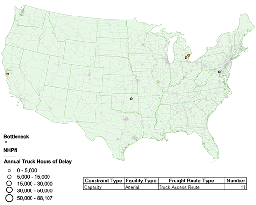
| Route Number | Bottleneck Location | No. of Lanes | All Vehicles-2004 | All Trucks-2004 | |||
|---|---|---|---|---|---|---|---|
| AADT | AADTT | Percent of All Vehicles | Annual Hours of Delay All Trucks | Annual Hours of Delay All Trucks (Expanded) | |||
| - | Montgomery, Maryland | 4 | 75,398 | 4,524 | 6% | 5,937 | 29,139 |
| - | Santa Clara, California | 4 | 72,025 | 5,762 | 8% | 1,517 | 1,517 |
| - | Oakland, Mississippi | 4 | 85,248 | 1,705 | 2% | 1,074 | 3,257 |
| - | Oakland, Mississippi | 4 | 71,196 | 3,560 | 5% | 1,046 | 3,849 |
| - | Oklahoma City, Oklahoma | 4 | 61,212 | 1,836 | 3% | 493 | 993 |
| - | Washtenaw, Mississippi | 4 | 55,019 | 4,402 | 8% | 457 | 457 |
| - | Tulsa, Oklahoma | 4 | 62,560 | 626 | 1% | 384 | 384 |
| - | Tulsa, Oklahoma | 4 | 62,560 | 626 | 1% | 304 | 304 |
| - | Champaign, Illinois | 4 | 49,077 | 2,945 | 6% | 202 | 202 |
| - | Washtenaw, Mississippi | 4 | 43,324 | 3,466 | 8% | 150 | 224 |
| - | Pulaski, Arkansas | 4 | 44,558 | 1,337 | 3% | 95 | 254 |