CHAPTER 2.0 FREIGHT TRANSPORTATION INFRASTRUCTURE
2.1 Study Area Definition
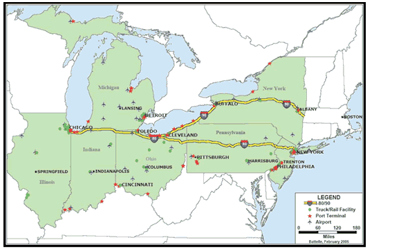
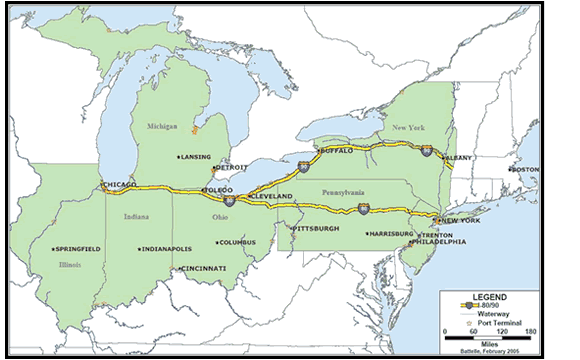
The corridor includes the freight shipments utilizing the highway and rail networks between Chicago, Illinois and New York, New York. The corridor includes the seven States connecting Illinois to New York: Indiana; Michigan; Ohio; Pennsylvania; and New Jersey. This is primarily an east-west corridor served by I-80 and I-90 Interstate highways and includes major parallel highways as well as north-south Interstates within the corridor. This corridor represents the major link between the East Coast and the Midwest, between the largest port on the East Coast with the industrial heartland, and the nation's business capital with the agricultural and manufacturing center of the country. Figure 2-1 shows the corridor and major highway systems that constitute the main east-west roadway links between Chicago and New York City. The figure also shows major cities along these Interstates. The corridor spans approximately 800 miles.
Traffic- and freight-generating activities in the corridor include some of the nation's major industrial, manufacturing, and distributing centers such as Detroit, Akron, Rochester, Philadelphia, Pittsburgh, and Columbus. Cleveland, Indianapolis and Buffalo also contribute significant commercial activities and those freight flows, as well as those traversing any part of the identified highways and rail lines are included in the corridor analysis.
This chapter describes the physical infrastructure of the highways, railroads and waterways within the study area. The discussion of the highway infrastructure presents the road networks, and discusses the regulations governing the operating characteristics of freight vehicles on those highways. The discussion of the railroad infrastructure provides a description of the railroad network and the ownership of the rail lines. Finally this chapter briefly summarizes the ports contained in the corridor.
2.2 Highway Network
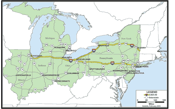
The main Interstate highways connecting the upper Midwest and East Coast are the I-80 and I-90 Interstates traversing seven States: Illinois, Indiana, Ohio, Michigan, Pennsylvania, New York, and New Jersey. Table 2-1 shows the mileage of the I-80 and I-90 Interstates across the corridor States, as well as each State's total Interstate Highway and National Highway System (NHS) miles. The lengths of I-80 and I-90 between Chicago and New York represent 30 percent and 24 percent, respectively, of their total distances across the nation. For the purposes of the corridor analysis, additional lengths of both I-80 and I-90 Interstates extending 100 miles west of Chicago are included.
| State | State (miles) I-80 |
State (miles) I-90 |
State (miles) Interstate |
State (miles) NHS |
|---|---|---|---|---|
| Illinois | 163 | 109 | 2,162 | 5,681 |
| Indiana | 152 | 21 | 1,171 | 2,883 |
| Michigan | 1,241 | 4,744 | ||
| Ohio | 237 | 102 | 1,575 | 4,384 |
| Pennsylvania | 311 | 46 | 1,776 | 5,486 |
| New York | 0 | 386 | 1,688 | 5,150 |
| New Jersey | 71 | 0 | 434 | 2,073 |
| Total | 935 | 665 | 10,047 | 30,401 |
| US Total | 2,889 | 2,796 | 46,747 | 161,131 |
The I-80 and I-90 Interstates together comprise 24.6 percent of the corridor's total Interstate and NHS mileage. At a national level, the Interstates contained within the corridor comprise 18.8 percent of the Interstate Highway System and 5.5 percent of the NHS. Of that, I-80 and I-90 represent approximately 3 percent of all Interstate mileage and less than one percent of the NHS mileage.
Important east-west segments of Interstate highways in the corridor include the following:
- I-76 from New Jersey and across Pennsylvania to I-71 just beyond Akron, Ohio
- I-78 in New Jersey and eastern Pennsylvania and New York Route 17 across counties in southern New York
- I-96, I-196, and I-94 across Michigan
- I-70 from the Pennsylvania-Maryland border to the Illinois-Missouri border
- I-74 from Cincinnati across Indiana and Illinois, bypassing the Chicago metropolitan area and joining I-80 just across the Mississippi River north of Bettendorf, Iowa
North-south routes passing through the corridor from east to west are:
- I-71 across Ohio from Cleveland to Cincinnati
- I-65 Nashville, Tennessee; Louisville, Kentucky; and Indianapolis, Indiana to Chicago
- I-75 Cincinnati, Ohio and Toledo, Ohio to Detroit
- I-77 originating in Columbia, South Carolina via Charleston, West Virginia to Cleveland
- I-81 in Tennessee via Roanake, Virginia and Harrisburg, Pennsylvania to Syracuse, New York
- I-69 from Indianapolis via Lansing, Michigan to Port Huron and Ontario
Table 2-2 shows relationships between population, Interstate mileage, and land area for the seven States along the corridor and for the other 41 continental States as a whole. While the population density for the corridor States is three times that of the average for other continental States, population served per Interstate mile for the corridor is only about 1.5 times greater than that for the other continental States. In contrast, the square miles of land area of the corridor States served per Interstate mile is 52 percent of that for the entire nation. Each mile of Interstate highway in the Chicago-New York City corridor serves more people than the average mile for the rest of the nation with more Interstate mileage per square mile in the corridor than for the other 41 continental States.
| Population per Square Mile | Population per Interstate Mile | Square Miles per Interstate Mile | |
|---|---|---|---|
| Corridor States | 271 | 9,025 | 33 |
| Other States | 93 | 5,966 | 64 |
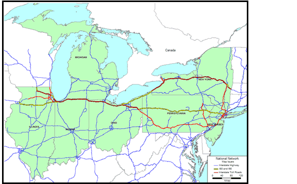
2.2.1 Turnpikes and Toll Roads
In 1956 when the Federal Aid Highway Act created the interstate system existing freeways, toll roads and turnpikes were utilized wherever possible. Many sections of the corridor's toll roads and turnpikes supersede the creation of the Interstate system. When they were brought into the Interstate system the roads retained their status as toll facilities under Grandfather provisions. The following sections of the highways in the corridor are tolled:
- I-80 starting from Joliet, Illinois is the Tri-State Tollway merging with I-90 at Gary, Indiana
- I-80 and I-90 share the right-of-way along the Indiana E-W Toll Road and the Ohio Turnpike
- I-90 is the Northwest Tollway in Illinois becoming the Chicago Skyway until it merges with I-80
- I-90 becomes the New York State Thruway and finally the I-90 Massachusetts Turnpike
- I-76 is the Pennsylvania Turnpike from the New Jersey border through Philadelphia to I-71 just beyond Akron, Ohio.
Table 2-3 summarizes the operating authority, location and length of the Interstate toll sections in the corridor States. Figure 2-2 shows the tolled highway sections along the corridor.
| Facility | Financing or Operating Authority | Location | Length (miles) |
|---|---|---|---|
| Illinois | |||
| East-West Tollway | Illinois State Toll Highway Authority | Various Sections | 98.5 |
| North-South Tollway | Illinois State Toll Highway Authority | Various Sections | 17.5 |
| Northwest Tollway | Illinois State Toll Highway Authority | Various Sections | 75.8 |
| Chicago Skyway | Illinois State Toll Highway Authority | Various Sections | 7.7 |
| Tri-State Tollway | Illinois State Toll Highway Authority | Various Sections | 82 |
| Indiana | |||
| Indiana East West Toll Road (I-80/90) | Indiana Department of Transportation | From Chicago Skyway and Indianapolis Boulevard to Ohio Turnpike Illinois Line | 156.8 |
| Michigan | |||
| Michigan | No toll roads or turnpikes | No toll roads or turnpikes | No toll roads or turnpikes |
| Ohio | |||
| Ohio Turnpike | Ohio Turnpike Commission | Pennsylvania State Line to junction Interstate 80 and Interstate 76 to the Indiana State Line | 392.2 |
| Pennsylvania | |||
| Pennsylvania Turnpike (I-76) | Pennsylvania Turnpike Commission | From Irwin to Carlisle | 159.5 |
| Eastern Extension (I-76) | Pennsylvania Turnpike Commission | From Carlisle to Valley Forge | 100.5 |
| Northeastern Extension | Pennsylvania Turnpike Commission | I-81 to I-276 | 110.3 |
| Western Extension (I-76) | Pennsylvania Turnpike Commission | From Irwin to Ohio Line | 67.1 |
| Delaware River Extension (I-276) | Pennsylvania Turnpike Commission | From Valley Forge to Delaware River Bridge | 31.9 |
| New York | |||
| New York State Thruway | NY State Thruway Authority | From Pennsylvania line to Albany and from New York City to Albany | 494.2 |
| New Jersey | |||
| New Jersey Turnpike Mainline | New Jersey Turnpike Authority | From GW Bridge to Penn Turnpike Exit | 72.4 |
| Newark Bay Extension | New Jersey Turnpike Authority | From Newark Airport to Holland Tunnel | 8.6 |
| Penn Turnpike Extension | New Jersey Turnpike Authority | From Delaware River Bridge to New Jersey Turnpike – westbound only | 5.6 |
2.2.2 Truck Size and Weight (TSW) Regulations
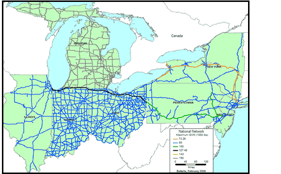
The United States has a long history of evolving truck, size and weight regulations. In general the federal size and weight regulations apply to Interstate highways (including tolled Interstate highways) except if the State allowed heavier or longer vehicles before the 1982 legislative "freeze" preventing further State changes on the Interstate system. Figure 2-3 summarizes the federal size and weight limits.
|
The Intermodal Surface Transportation Efficiency Act of 1991 (ISTEA) enforced a freeze limiting the use of longer, heavier double and triple trailer combinations to those states in which they were already operating in 1991. The size and weight limits included in the 1991 grandfather provisions are summarized in Table 2-4, for the corridor States. Table 2-5 shows the truck size and weight rules on the corridor's turnpikes and toll roads. The gross-vehicle weights (GVW) displayed in the following tables and maps show the maximum GVW. The number of truck axles required will vary with different truck weights, the number of axles is determined by either the Bridge Formula B or a slightly modification of that formula.2
| State | Truck Tractor and Two Trailing Units | Truck Tractor and Three Trailing Units | Other |
|---|---|---|---|
| Length in Feet ('), Weight in 1,000 pounds (K) | |||
| Indiana | 106', 127.4K | 104.5', 127.4K | 58' |
| Michigan | 58', 164K | No | No |
| New York | 102', 143K | No | No |
| Ohio | 102', 127.4K | 95', 115K | No |
| State | Longer/Heavier Combinations/Turnpike/Toll Road Operations |
|---|---|
| Illinois | None |
| Indiana | The Indiana Toll Road Commission will authorize the movement of twin 48-foot, 6-inch trailer combinations not exceeding 127,400 lbs GVW on the toll road. Triple trailer combinations are allowed on the toll road only subject to 28-foot trailer length, no overall length limit, and 127,400 lbs GVW. |
| Michigan | None |
| Ohio | The Ohio Turnpike Authority will allow a tractor-semitrailer and short doubles combination no longer than 75 feet or turnpike doubles up to 90 feet without a permit. Both are subject to 127,400 lbs GVW. Combinations exceeding 90 feet must obtain an operating permit, which includes mileage-based fees. Special permission required on doubles travel. |
| Pennsylvania | The Pennsylvania Turnpike Authority will allow twin 28-foot, 6-inch trailers on the turnpike, subject to an overall length of 85 feet and 100,000 lbs GVW. Triple trailer combinations are not allowed. |
| New York | The New York Thruway Authority allows twin 48-foot turnpike doubles subject to 114-foot overall length, 143,000 lbs GVW, and equipment and driver certification. No triple combinations are allowed. |
| New Jersey | None |
Figure 2-4 through Figure 2-6 geographically display the maximum gross vehicle weight limits in the corridor states: Figure 2-4 shows single trailer limits; Figure 2-5 shows double trailer limits; Figure 2-6 shows triple trailer limits. With the exception of Michigan and some Illinois State highways the single trailer weight and length limits are remarkable uniform throughout the corridor.
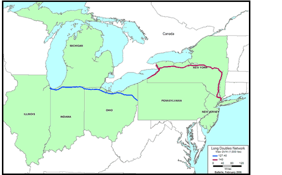
The network of highways, toll roads and turnpikes that allow doubles in the corridor States represent a hodge-podge of different GVW and length limits. When one considers only the network of long doubles as defined by those greater than twin 28.5-foot trailers, the doubles network is reduced to 3 states, Indiana, Ohio and New York.
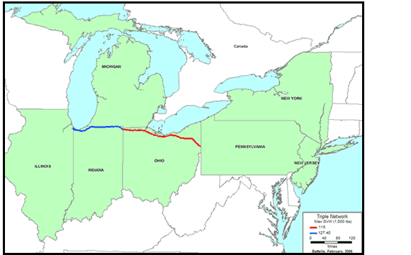
Triple trailers are only allowed in two of the corridor States. Indiana and Ohio have two different weight limits but the same trailer length limits. They are primarily utilized by less-than-truckload carriers such as UPS and Fed-Ex. The 28-foot trailers used in triples are operated as STAA double trailers in other states.
Similar to the maximum GVW among the corridor States, the single and short double trailer-length requirements are consistent among the corridor States but the length allowance for double trailers and triples are different among the States. Table 2-6 shows the uniformity of the maximum semitrailer lengths for the corridor States.
| National Network for Large Trucks State |
National Network for Large Trucks Length |
National Network for Large Trucks Kingpin |
Other State Highway Length |
Other State Highway Kingpin |
Other State Highway Overall |
|---|---|---|---|---|---|
| Illinois | 53-0 | 42-6 KCRA | 53-0 | 42.0 KCRA | |
| Indiana | 53-0 | 40-6 KCRA | 53-0 | 40-6 KCRA | |
| Michigan | 53-0 | 41-0 KCRT | 50-0 | ||
| New Jersey | 53-0 | 41-0 KCRT | 53-0 | 41-0 KCRT | |
| New York | 53-0 | 41-0 KCRT | No limit | 60-0 | |
| Ohio | 53-0 | 53-0 | |||
| Pennsylvania | 53-0 | No limit | 60-0 |
KCRT = Kingpin to center of rear tandem
2.2.3 Over Size/Over Weight Permits
States have the option to issue over-size/over-weight (OS/OW) permits. For non-divisible loads, states may issue permits without regard to the axle, gross, or Federal bridge formula requirements. A non-divisible load is defined as any load or vehicle exceeding applicable length or weight limits which if loaded into smaller loads or vehicles, would: compromise the intended use of the vehicle, destroy the value of the load or vehicle, or require more than 8 work hours to dismantle using appropriate equipment. States may issue designated divisible load permits based on historic State "grandfather" rights or Congressional authority for a state-specific commodity or route.
Overweight divisible loads are permitted in approximately half of the states in the United States, with some states allowing only specific commodities such as nuclear waste to receive permits. On the other hand, single-trip permits are issued in 12 states, while 21 states issue annual trip permits for divisible loads. Table 2-7 shows the number of permits issued by the corridor States in 2003.
Indiana issues permits that are valid for one day from steel mills to the Michigan Line. These permits allow a GVW of 134,000 pounds on designated routes. Indiana issues annual permits for travel less than 15 miles to or from Indiana toll roads (not including Interstate routes) with a maximum allowable weight of 127,400 pounds. Pennsylvania issues annual permits at a flat fee for flat rolled steel coils, raw milk, and bulk animal feed for non-Interstate highways. In addition, divisible single-trip permits are granted. New York grants annual divisible permits only and non-divisible single trip permits for a maximum GVW of 120,000 pounds. Fees charged for the various permits are dependent on the vehicle type/configuration, valid counties, and GVW.
| State | Non-divisible Single Trip |
Non-divisible Annual |
Divisible Single Trip |
Divisible Annual |
Permits/Year | Percent of National Permits |
|---|---|---|---|---|---|---|
| Illinois | 133,619 | 0 | 0 | 0 | 133,619 | 3.82% |
| Indiana | 125,630 | 0 | 68,369 | 13,610 | 207,609 | 5.93% |
| Michigan | 102,056 | 21,220 | 0 | 216 | 123,492 | 3.53% |
| Ohio | 92,751 | 4,028 | 6,810 | 17,186 | 120,775 | 3.45% |
| Pennsylvania | 104,830 | 7,310 | 0 | 0 | 112,140 | 3.20% |
| New York | 116,587 | 4,989 | 0 | 72,394 | 193,970 | 5.54% |
| New Jersey | 9,592 | 0 | 0 | 0 | 9,592 | 0.27% |
| National Total | 2,629,392 | 234,697 | 258,296 | 377,482 | 3,544,449 |
2.3 Rail Network
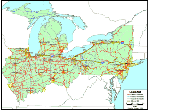
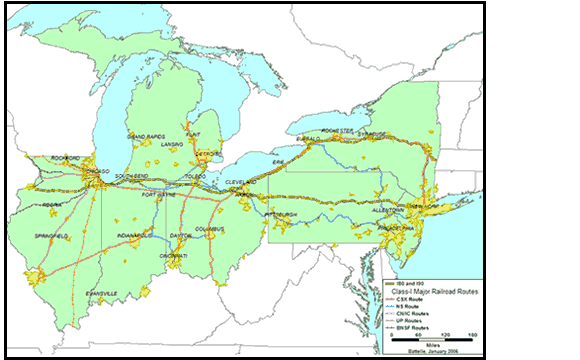
Freight rail is an important part of the transportation system in the corridor. All the states have extensive rail networks and are serviced by at least two major Class I Railroads. As defined by the Surface Transportation Board in 2002, a Class I Railroad is a railroad with operating revenues of at least $272 million. A Regional Railroad is a non-Class I, line-haul railroad operating 350 or more miles of road or with revenues of at least $40 million. A Local Railroad is neither a Class I nor Regional and is engaged primarily in line-haul service. Switching and Terminal Railroads do not offer point-to-point service but rather pickup and delivery service for a connecting line-haul railroad. Table 2-8 provides the number of railroad entities and the railroad miles operated in the corridor States. Table 2-9 provides similar information for Class I Railroads by the railroad entity. Figure 2-7 shows the network of Class I, II and III Railroads in the corridor States and Figure 2-8 shows railroads by ownership.
The major Class I Railroads serving the corridor are CSX and Norfolk Southern (NS). CSX operates a 23,000-mile rail network in the eastern United States and NS operates 21,500 route miles in the same region. Of these miles, 39 percent of CSX miles and 48 percent of NS miles are within the study corridor. Both companies serve lake and seaports within the Chicago-New York City corridor and connect with Class I railroads and short line railroads in the West.
The corridor has undergone major railroad network changes since the Staggers Rail Act of 1980 deregulated railroads to a significant extent. Following the act Railroads may largely determine their rates and operations. The Class I railroads have shed short line operations through sales to Class II and III operations and there have been major consolidations. In 1998 the Surface Transportation Board approved the joint acquisition of Consolidated Rail (Conrail) by CSX Transportation and Norfolk Southern.
| Number of Railroads in Corridor (2003) | ||||||
|---|---|---|---|---|---|---|
| State | Class I | Regional | Local | Switching and Terminal | Canadian1 | Total |
| Illinois | 7 | 4 | 11 | 18 | 0 | 40 |
| Indiana | 5 | 2 | 19 | 13 | 0 | 39 |
| Michigan | 4 | 2 | 8 | 7 | 0 | 21 |
| Ohio | 3 | 2 | 12 | 16 | 0 | 33 |
| Pennsylvania | 3 | 3 | 28 | 24 | 1 | 59 |
| New York | 2 | 4 | 20 | 7 | 2 | 35 |
| New Jersey | 2 | 1 | 7 | 6 | 1 | 17 |
| United States, Total | 7 | 31 | 314 | 204 | 2 | 558 |
| Miles of Railroad | ||||||
|---|---|---|---|---|---|---|
| State | Class I | Regional | Local | Switching and Terminal | Canadian1 | Total |
| Illinois | 5,932 | 365 | 719 | 322 | 0 | 7,338 |
| Indiana | 2,890 | 57 | 1,071 | 174 | 0 | 4,192 |
| Michigan | 2,025 | 405 | 973 | 187 | 0 | 3,590 |
| Ohio | 3,302 | 702 | 813 | 362 | 0 | 5,179 |
| Pennsylvania | 2,481 | 651 | 1,317 | 484 | 127 | 5,060 |
| New York | 1,610 | 292 | 1,135 | 127 | 389 | 3,553 |
| New Jersey | 190 | 78 | 188 | 461 | 0 | 917 |
The corridor is a leader in the formation of multi-state and public-private partnerships to improve railroad infrastructure. The corridor contains New Jersey and New York Port Inland Distribution Network (PIDN) and the Chicago CREATE project.
The following sections detail the ownership and operations of the railroads in the corridor.
2.3.1 Norfolk Southern
Norfolk Southern (NS) operates 21,500 route miles in 22 eastern states, the District of Columbia and the province of Ontario, Canada. NS carries traffic from New York to Chicago on its own lines. Two routes travel from Buffalo to Chicago one line going through Cleveland and Ft. Wayne and the other across southern Ontario and through Detroit. NS also provides service to Kansas City, St. Louis, and beyond for corridor cities such as Columbus, Buffalo, Cleveland, Detroit, and Toledo. In 1998 NS was augmented with the acquisition of over half of Conrail.
| Railroad (mileage of ownership) | State Illinois |
State Indiana |
State Michigan |
State Ohio |
State Pennsylvania |
State New York |
State New Jersey |
Corridor Totals |
|---|---|---|---|---|---|---|---|---|
| Burlington Northern & Santa Fe Railroad (BNSF) | 1,414 | 1,440 | ||||||
| Canadian National Railway (CN) | 800 | 3 | ||||||
| Canadian Pacific Railway (CPR) | 452 | 3 | 68 | 1,326 | ||||
| CSX Transportation | 1,045 | 1,715 | 809 | 1,925 | 1,062 | 1,309 | 648 | 9,088 |
| Grand Truck Corporation (GTC) | 1,519 | 80 | 1,016 | 7 | 155 | 2,618 | ||
| Kansas City Southern Railway Co. (KCSR) | 186 | 169 | ||||||
| Norfolk Southern (NS) | 1,260 | 1,543 | 644 | 2,233 | 2,433 | 862 | 933 | 10,080 |
| Soo Line Railroad Co. (SOO) | 356 | 291 | 262 | 909 | ||||
| Union Pacific Railroad (UPR) | 2,247 | 4 | 2,245 | |||||
| Total Class 1 and Canadian | 8,027 | 3,633 | 2,731 | 4,165 | 4,102 | 2,974 | 1,649 | 27,878 |
Includes Trackage Rights. Excludes 362 miles owned by Amtrak. All or some of the Amtrak mileage might be operated by freight railroads under trackage rights.
2.3.2 CSX Transportation
CSX Transportation (CSX) is the other major Class I railroads serving the corridor. In 1998 CSX acquired 42 percent of Conrail's assets. As a result of the transaction CSX's rail operations through its new subsidiary New York Central Lines, grew to include 3,800 miles of the Conrail system. These lines include the former Conrail lines connecting the east coast ports of Boston, New York, Philadelphia, and Baltimore to Chicago and St. Louis. The CSX rail line to Chicago parallels the Norfolk Southern rail lines. CSX also serves Detroit and several other major cities in Michigan.
2.3.3 Grand Trunk Western Railroad / Canadian National Railway
The Grand Truck Western Railroad (GWT) is a subsidiary of the Canadian National (CN) Railway's Grand Truck Corporation. A CN system-wide re-branding beginning in 1995 has seen the GT and GWT logo largely replaced by its parent company. GTW line serves as CN's connection between Prot Huron and Chicago, Illinois, where the railroad connects to CN subsidiaries Wisconsin Central Ltd. and Illinois Central, and other US railroads.
2.3.4 Soo Line / Canadian Pacific Railway
Canadian Pacific Railway (CPR) operates the Soo Line. CPR provides freight connections to Canada and the northern States of Wisconsin and Minnesota as part of their network. In the corridor States, the Soo Line miles are present in Illinois, Michigan, and Indiana. Canadian Pacific Railway (CPR) also own limited miles in New Jersey, New York, and Pennsylvania.
2.3.5 Regional Railroads
The Association of American Railroads (AAR) defines regional lines as non-Class I Railroads operating more than 350 miles of road and/or with revenues of at least $40 million. There are 2,836 miles of regional railroad including trackage rights in the corridor. The major regional railroad operators in the corridor include the following:
- Iowa, Interstate Railroad Ltd. – Illinois, 218 miles of railroad including trackage rights
- New York, Susquehanna and Western Railway – New Jersey, 78 miles; New York, 306 miles
- Tuscola & Saginaw Bay Railway – Michigan, 396 miles
- Buffalo and Pittsburgh Railroad, Inc. – Pennsylvania, 224 miles; New York, 146 miles
- Wheeling and Lake Erie Railway Co. – Pennsylvania, 185 miles.
2.3.6 Local and Switching Lines
The Association of American Railroads (AAR) defines shortline railroads as primarily engaged in operating railroads for the transport of cargo over a short distance, usually less than 100 miles, on local rail lines not part of a rail network. A switching line is typically a road servicing a relatively confined area, such as a port, a metropolitan area, an industrial complex or even, in some cases, a single industry. For example, "Little" Conrail is a switching carrier that works the "shared asset" areas. These areas were created out of the Conrail transaction and include Detroit and the areas of Northern New Jersey to the Philadelphia area.
An interline carrier is a full participant in all aspects of marketing and accounting including the new Interline Settlement System (ISS), which became mandatory for the rail industry on October 1, 1996. This relationship is most prevalent among Class I, Class II, and relatively large shortline railroads. A Junction Settlement Road or Handling Line is a shortline road for which its settlement of revenue is performed by connecting carriers.
2.4 Water Network
The corridor encompasses two major waterway systems, the port of New York and New Jersey and the great lakes. The Army Corps of Engineers oversees inland waterways, inland ports and many deep-water ports. Water freight is primarily a private sector service regulated by federal and state laws. Harbor depth, lock length and federal laws define the utilization of the waterway system. Table 2-10 identifies the important water ports based on total tonnage of freight in 2002. Figure 2-9 shows the waterways in the corridor as well as the locations of ports. The major water ports in the area include the Port of New York and New Jersey, Chicago, Huntington (KY-OH-WV), Pittsburgh, Philadelphia, and Detroit.
| Port Name | Total Ton | Domestic | Foreign | Imports | Exports | National Ranking by Tons |
|---|---|---|---|---|---|---|
| New York, NY and NJ | 134,504,500 | 64,372,653 | 69,571,858 | 59,419,046 | 10,152,812 | 3 |
| Huntington, tri-state* | 81,063,663 | 81,063,663 | 0 | 0 | 0 | 6 |
| Pittsburgh, PA | 52,050,661 | 52,050,661 | 0 | 0 | 0 | 13 |
| Philadelphia, PA | 34,100,664 | 13,719,934 | 20,380,733 | 20,073,391 | 307,342 | 20 |
| Chicago, IL | 20,402,907 | 18,777,496 | 1,625,411 | 1,059,317 | 566,094 | 35 |
| Detroit, MI | 17,305,875 | 12,897,162 | 4,408,713 | 4,201,545 | 207,168 | 39 |
2.5 Intermodal Facilities and Connectors
Public roads leading to major intermodal terminals are designated NHS connectors by the USDOT, in cooperation with State departments of transportation and metropolitan planning organizations. Several criteria are considered, including the level of activity of an intermodal terminal and its importance to a State's economy. In the United States, there are 517 freight-only terminals and 99 major airports that handle both passengers and freight. These 616 intermodal freight terminals are connected to the NHS by 1,222 miles of connectors. The Chicago - New York City corridor contain 22 percent of these connector miles.
Table 2-11 lists the number of the NHS intermodal terminals by State. Ohio contains 21 port terminals along its 312-mile Lake Erie shoreline. Illinois has 34 percent of the corridor's rail/truck terminals asserting its importance as a rail hub linking the Midwest to the western States. The only three truck/pipeline terminals are located in Pennsylvania, 40 miles south of I-80 with direct NHS connectors linking with I-76, the Pennsylvania Turnpike. Figure 2-10 shows the locations of truck/rail and other intermodal facilities in the corridor States.
| State | Port Terminal | Truck/Rail Facility | Truck/Pipeline Terminal |
|---|---|---|---|
| Illinois | 5 | 24 | 0 |
| Indiana | 3 | 1 | 0 |
| Michigan | 9 | 8 | 0 |
| Ohio | 21 | 11 | 0 |
| Pennsylvania | 9 | 9 | 3 |
| New York | 8 | 9 | 0 |
| New Jersey | 6 | 5 | 0 |
http://ops.fhwa.dot.gov/freight/freight_analysis/nhs_connect.htm.