U.S. Department of Transportation
Federal Highway Administration
1200 New Jersey Avenue, SE
Washington, DC 20590
202-366-4000
Table IN-2
October 2012
| ASIA | EUROPE | NORTH AMERICA | ||||||
|---|---|---|---|---|---|---|---|---|
| CHINA |
JAPAN |
FRANCE |
GERMANY |
U.K. |
CANADA |
MEXICO |
U.S. |
|
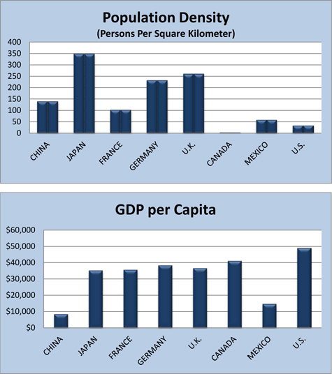
| Population 1/ | 1,343,239,923 | 127,366,088 | 65,630,692 | 81,305,856 | 63,047,162 | 34,300,083 | 114,975,406 | 313,847,465 |
| Land Area 1/ (square kilometers) |
9,569,901 | 364,485 | 640,053 | 348,672 | 241,930 | 9,093,507 | 1,943,945 | 9,161,966 |
| Population Density (persons per square kilometer) |
140.4 | 349.4 | 102.5 | 233.2 | 260.6 | 3.8 | 59.1 | 34.3 |
| GDP (trillion $) 1/ (Purchasing Power Parity) |
$11.44 | $4.50 | $2.25 | $3.14 | $2.29 | $1.41 | $1.68 | $15.29 |
| GDP per Capita ($) 1/ (Purchasing power parity) |
$8,500 | $35,200 | $35,600 | $38,400 | $36,600 | $41,100 | $14,800 | $49,000 |
1/ Data source: "The World Fact Book" of the U.S. Central Intelligence Agency (CIA). Data for population is estimated as of July 2012, and 2011 for GDP data..