U.S. Department of Transportation
Federal Highway Administration
1200 New Jersey Avenue, SE
Washington, DC 20590
202-366-4000
Table IN-2
July 2013
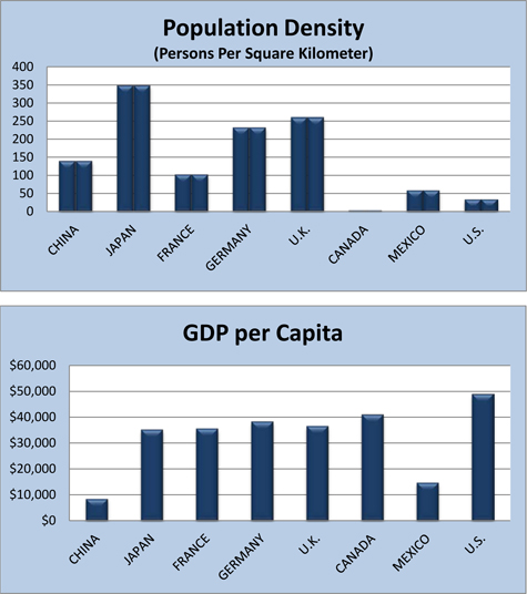
| ASIA | EUROPE | NORTH AMERICA | ||||||
|---|---|---|---|---|---|---|---|---|
| CHINA |
JAPAN |
FRANCE |
GERMANY |
U.K. |
CANADA |
MEXICO |
U.S. |
|
| Population | 1,349,585,838 | 127,253,075 | 65,951,611 | 81,147,265 | 63,395,574 | 34,568,211 | 116,220,947 | 316,668,567 |
| Land Area (square kilometers) |
9,569,901 | 364,485 | 640,053 | 348,672 | 241,930 | 9,093,507 | 1,943,945 | 9,161,966 |
| Population Density (persons per square kilometer) |
141.0 | 349.1 | 103.0 | 232.7 | 262.0 | 3.8 | 59.8 | 34.6 |
| GDP (trillion $) (Purchasing Power Parity) |
$12.38 | $4.53 | $2.25 | $3.12 | $2.32 | $1.45 | $1.76 | $15.65 |
| GDP per Capita ($) (Purchasing power parity) |
$9,100 | $36,200 | $35,500 | $39,100 | $36,700 | $41,500 | $15,300 | $49,800 |
(1) Data source: "The World Fact Book" of the U.S. Central Intelligence Agency (CIA). Data for population is estimated as of July 2013, and 2012 for GDP data..