U.S. Department of Transportation
Federal Highway Administration
1200 New Jersey Avenue, SE
Washington, DC 20590
202-366-4000
Focus
| Accelerating Infrastructure Innovations |
Publication Number: FHWA-HRT-05-028
Date: July 2005
Engineers and highway planners looking for geophysical solutions to construction challenges are finding assistance in a new manual available from the Federal Highway Administration (FHWA).
Developed by FHWA's Central Federal Lands Highway Division office in partnership with Blackhawk GeoServices, Applications of Geophysical Methods to Highway Related Problems offers geophysical approaches and solutions to many tasks and problems related to highway construction. "Engineers sometimes shy away from using geophysics due to a lack of knowledge on the subject," says Khamis Haramy of FHWA. "The goal was to provide a reference manual that is focused on problems and solutions specifically related to transportation projects, rather than just a textbook discussion of geophysical methods."
Geophysical methods allow for nondestructive investigation below the ground surface of a pavement, bridge deck, or other structure. They are not intended to replace conventional investigation methods such as borings, but can enable the collection of data over large areas in much less time than other, invasive methods, and generally cost less than invasive forms of data collection. The geophysical methods can be applied during the planning, construction, and maintenance of roads and structures. When planning a road project, for example, an engineer might use geophysics to analyze the properties of the soil below a paved section to ensure that the road can support the traffic loads or to locate competent soil layers or bedrock to design bridge foundations. During the construction phase of a bridge project, an engineer could use geophysics to test the bridge foundation integrity or the capacity and stresses of a driven pile, as well as to monitor vibrations during construction. Geophysics can also be applied to the maintenance of roads and bridges by using such technologies as ground penetrating radar (GPR) to evaluate how well a pavement or bridge deck is holding up and when it might need replacing.
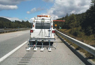
Geophysical technologies, such as the ground penetrating radar shown here, can be used to evaluate how well a pavement or bridge deck is holding up.
The manual contains chapters on different geophysical engineering applications, including using geophysics for pavements, bridge system substructures, bridge system superstructures, and subsurface characterization. Applications for bridge system substructures, for example, include using nondestructive test (NDT) methods to determine the unknown depth of bridge foundations. Surface NDT methods include sonic echo/impulse response, bending waves, and ultraseismic tests. If further access is required, borehole NDT methods can be used, where a borehole is drilled close to the foundation structure, extending along its length. For each method, the manual briefly outlines the basic concept, its application to specific engineering problems, and procedures for field data acquisition, processing, and interpretation. Also discussed are the advantages and limitations presented by each method.
"The manual is organized to assist the engineer in gaining knowledge of the state of the practice rather than becoming expert in the application of these methods," says Haramy.
Pavement applications described in the manual include using GPR to track the moisture variation within a pavement and using GPR, seismic, surface wave, and impact echo testing to measure pavement integrity.
"An engineer can use the manual to determine whether or not a geophysical approach would produce the best value and the most cost savings on a given project," says Haramy.
The manual also includes chapters that focus on specific geophysics topics, such as vibration measurements, geophysical quantities, and borehole geophysical methods. References are listed at the end of each chapter for readers who would like more indepth information. A bibliography is also provided.
FHWA is developing a series of geophysics training workshops for State highway agency engineers that are expected to begin in the fall of 2005. The workshops will provide a hands-on introduction to geophysical methods, using the new applications manual as a textbook, as well as information on collecting, processing, and analyzing geophysics data and contracting with a geophysical company.
The manual is available online at www.cflhd.gov/geotechnical. For more information, contact Khamis Haramy at FHWA, 720-963-3521 (email: khamis.haramy@fhwa.dot.gov).

