U.S. Department of Transportation
Federal Highway Administration
1200 New Jersey Avenue, SE
Washington, DC 20590
202-366-4000
Federal Highway Administration Research and Technology
Coordinating, Developing, and Delivering Highway Transportation Innovations
 |
| This report is an archived publication and may contain dated technical, contact, and link information |
|
Publication Number:
FHWA-HRT-05-159
|
Previous | Table of Contents | Next
Pile foundations are used extensively for the support of buildings, bridges, and other structures to safely transfer structural loads to the ground and to avoid excess settlement or lateral movement. They are very effective in transferring structural loads through weak or compressible soil layers into the more competent soils and rocks below. A "driven pile foundation" is a specific type of pile foundation where structural elements are driven into the ground using a large hammer. They are commonly constructed of timber, precast prestressed concrete (PPC), and steel (H-sections and pipes).
Historically, piles have been used extensively for the support of structures in Boston, MA. This is mostly a result of the need to transfer loads through the loose fill and compressible marine clays that are common in the Boston area. Driven piles, in particular, have been a preferred foundation system because of their relative ease of installation and low cost. They have played an important role in the Central Artery/Tunnel (CA/T) project.
The CA/T project is recognized as one of the largest and most complex highway projects in the United States. The project involved the replacement of Boston's deteriorating six-lane, elevated central artery (Interstate (I) 93) with an underground highway; construction of two new bridges over the Charles River (the Leverett Circle Connector Bridge and the Leonard P. Zakim Bunker Hill Bridge); and the extension of I–90 to Boston's Logan International Airport and Route 1A. The project has been under construction since late 1991 and is scheduled to be completed in 2005.(1)
Driven pile foundations were used on the CA/T for the support of road and tunnel slabs, bridge abutments, egress ramps, retaining walls, and utilities. Because of the large scale of the project, the construction of the CA/T project was actually bid under 73 separate contracts. Five of these contracts were selected for this study, where a large number of piles were installed, and 15 pile load tests were performed. The locations of the individual contracts are shown in figure 1 and summarized in table 1. A description of the five contracts and associated pile-supported structures is also given below.
1. Contract C07D1 is located adjacent to Logan Airport in East Boston and included construction of a part of the I–90 Logan Airport Interchange roadway network. New roadways, an egress ramp, retained fill sections, a viaduct structure, and retaining walls were all constructed as part of the contract.(2) Driven piles were used primarily to support the egress ramp superstructure, abutments, roadway slabs, and retaining walls.
2. Contract C07D2 is located adjacent to Logan Airport in East Boston and included construction of a portion of the I–90 Logan Airport Interchange. Major new structures included highway sections, a viaduct structure, a reinforced concrete open depressed roadway (boat section), and at-grade approach roadways.(2) Driven piles were used to support the boat section, walls and abutments, and portions of the viaduct.
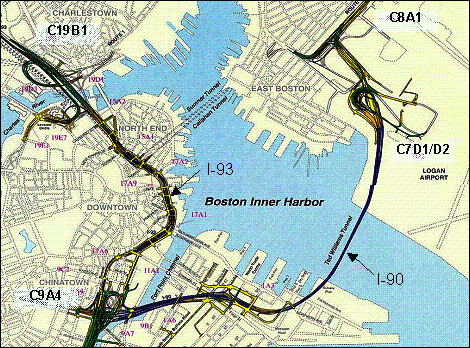
Figure 1. Locations of selected contracts from the CA/T project.(3)
| Contract | Location | Description |
|---|---|---|
| C07D1 | Logan Airport | I–90 Logan Airport Interchange |
| C07D2 | Logan Airport | I–90 Logan Airport Interchange |
| C08A1 | Logan Airport | I–90 and Route 1A Interchange |
| C09A4 | Downtown | I–93/I–90 Interchange, I-93 Northbound |
| C19B1 | Charlestown | I–93 Viaducts and Ramps North of the Charles River |
3. Contract C08A1 is located just north of Logan Airport in East Boston and included construction of the I–90 and Route 1A interchange. This contract involved new roadways, retained fill structures, a viaduct, a boat section, and a new subway station.(2) Both vertical and inclined piles were used to support retaining walls and abutments.
4. Contract C09A4 is located just west of the Fort Point Channel in downtown Boston. The contract encompassed construction of the I–90 and I–93 interchange, and the northbound section of I–93. Major new structures included surface roads, boat sections, tunnel sections, viaducts, and a bridge.(2) Piles were used to support five approach structures that provide a transition from on-grade roadways to the viaduct sections. Piles were also used to support utility pipelines.
5. Contract C19B1 is located just north of the Charles River in Charlestown. The contract included the construction of viaduct and ramp structures forming an interchange connecting Route 1, Storrow Drive, and I–93 roadways. Major new structures included roadway transition structures, boat sections, retaining walls, and a stormwater pump station.(2) Piles were used to support the ramp structures that transition from on-grade roadways to the viaduct or boat sections.
The overall objective of this report is to document the lessons learned from the installation of driven piles on the CA/T project. This includes review and analysis of pile design criteria and specifications, pile driving equipment and methods, issues encountered during construction, dynamic and static load test data, and cost data for different pile types and site conditions.
This report consists of six chapters, the first of which presents introductory and background information about the contracts where significant pile driving occurred. The second chapter discusses the criteria and specifications used for pile design and construction on the CA/T project. The third chapter documents the equipment and methods used for pile driving. Major construction issues encountered during driving, such as pile and soil heave, are also discussed. The fourth chapter presents the results of pile load tests performed on test piles using static and dynamic test methods, including a discussion of axial capacity, dynamic soil parameters, and pile driving criteria. The fifth chapter presents the unit costs for pile driving and preaugering for the different pile types used, as identified in the original construction bids. Finally, the sixth chapter summarizes the important findings of this study.

