U.S. Department of Transportation
Federal Highway Administration
1200 New Jersey Avenue, SE
Washington, DC 20590
202-366-4000
Federal Highway Administration Research and Technology
Coordinating, Developing, and Delivering Highway Transportation Innovations
 |
| This report is an archived publication and may contain dated technical, contact, and link information |
|
Publication Number: FHWA-RD-03-052 Date: May 2005 |
Field Observations and Evaluations of Streambed Scour At BridgesCHAPTER 6: SCOUR CAUSED BY FLOW CONTRACTION AT BRIDGESGENERALContraction and local abutment scour are a result of flow acceleration caused by encroachment of highway embankments and abutments onto the main channel and (or) floodplain. The accelerated velocity produces an increase in sediment transport from the bridge section until equilibrium conditions are reached or the bed becomes armored. Contraction scour is usually associated with flow acceleration in the contracted opening parallel to the channel and can occur throughout the bridge cross section. Abutment scour only occurs near the abutment and is associated with the localized flow curvature and acceleration near the ends of the bridge abutments as the flow separates from the channel boundary. Contraction and abutment scour often are treated independently because they are caused by different processes as the flow accelerates through a contracted opening; however, the separation of contraction and abutment scour is often difficult in field observations of scour. Treating the components of scour as independent and additive may be appropriate for wide, shallow bridge crossings, but may not be appropriate for narrow bridge openings. HEC-18 treats contraction and abutment scour as separate and additive because the equations used to compute these scour components were developed with this assumption. DISCUSSION OF PREDICTIVE EQUATIONSGeneralMost scour equations are either theoretically derived or empirically developed from small-scale laboratory research. Controlled laboratory settings tend to oversimplify or ignore many of the complexities present in the natural setting. Laboratory research is typically conducted in straight laboratory flumes with uniform flow, noncohesive uniform bed material, and limited verification of results with field data. Although contraction and abutment scour may be interrelated, laboratory tests typically study these components independently. Before applying a scour prediction equation, it is important to recognize the limitations of the equations, the conditions for which the equations were developed, the methods used to develop them, and how the underlying data were interpreted. Contraction ScourContraction scour has traditionally been classified as live bed or clear water. The live bed condition is characterized by bed material's being transported into the contracted opening from upstream of the bridge. Live bed scour is typical of scour that occurs in the main channel portion of a waterway in high-flow conditions. Clear water contraction scour occurs when the flow conveyed to the bridge crossing is not transporting bed material; thus, all material that is transported from the contracted section is sediment being scoured. Scour occurring on vegetated floodplains may be classified as clear water scour despite the potential for the shear stress in the approach section to be greater than the critical shear stress of the material comprising the floodplains. Four approaches can be used to estimate the elevation of the scoured bed in a contracted section:
These methods do not compute the depth of contraction scour directly, but rather the equilibrium depth of flow in the contracted section. Regime equations attempt to quantitatively describe the shape, width, and depth of channels that are "in regime," or have reached equilibrium—a state in which they are neither aggrading nor degrading. Much of the research on the proposed regime equations was based on canals in India during the 1930s and 40s. Regime equations depend highly on the similarity of the site conditions for which they were developed. Because the equations were predominately based on conditions in India and the western United States, they usually are not applicable to areas outside these regions. Hydraulic geometry relations are similar to regime equations and use at-a-station relations to describe the change in geometry of a single cross section for varying discharge. As with regime equations, these relations are empirical, and the limitations are dependent on the similarity between the site conditions being analyzed and those for which the equations were developed. Numerical sediment transport models can also be used to compute the depth of scour in a contracted bridge opening. Models are available from several Federal agencies and some private companies. The primary difference among the models is whether they are two-dimensional, one-dimensional, or one-dimensional stream-tube models. The cost of applying the models and the difficulty of setting up the models to accurately replicate field conditions have limited their use for prediction of contraction scour. Numerical models are sometimes used where site conditions are complex and (or) the estimated depth of scour has a significant effect on the design and cost of a proposed bridge. Semi-empirical contraction scour equations are based on sediment transport and uniform flow formulas. These relations are commonly used and are recommended by FHWA in HEC-18.(6) Because these equations are widely used, a more detailed discussion is provided. Following the traditional body of research on contraction scour, these equations are divided into the live bed and clear water classifications. Live Bed Contraction Scour Equations Straub was the first to develop an approach to predict contraction scour that most others would follow.(79) He assumed that the bed in the contracted section would scour until it reached a depth at which the local transport capacity was equal to the amount of material being supplied from upstream (sediment discharge continuity). He selected the DuBoys sediment transport equation to compute the amount of material supplied to the reach and the local transport capacity in the contraction. Straub estimated the energy dissipation rate (friction slope) in the contracted and uncontracted reaches using Manning's equation. This assumption is reasonable where flow curvature is small and pressure gradients are small compared to boundary stresses. The hydraulics in a short contraction, such as a bridge crossing, require the consideration of additional energy losses not accounted for in a roughness coefficient based on the channel composition and configuration.(80,81,82) Straub's equation, based on sediment discharge continuity, water discharge continuity, and the Manning equation, has the general form of equation 41:
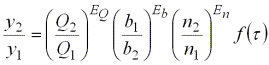
where y2 is the depth in the contracted section; y1 is the depth in the uncontracted section; Q2 is the discharge in the contracted section; Q1 is the discharge in the uncontracted section; EQ is the exponent on the ratio of discharges; b1 is the bottom width in the uncontracted section; b2 is the bottom width in the contracted section; Eb is the exponent on the ratio of bottom widths; n2 is the Manning's n in the contracted section; n1 is the Manning's n in the uncontracted section; En is the exponent on the ratio of roughness coefficients; and
For most applications, the shear stress-based function is assumed equal to unity. Laursen(61) followed Straub's approach but used his own sediment transport equation.(83) Richardson and Richardson modified Laursen's live bed equation by removing the ratio of Manning's n in equation 41.(84) They concluded that Laursen's equation did not account correctly for the increase in transport that would occur if a plane bed existed in the contracted opening with a dune bed configuration in the approach section. For this situation, Laursen's equation would predict less scour than if the roughness coefficients were equal. The Manning's n ratio in Laursen's equation does, in fact, behave properly. The basic principle of estimating contraction scour is the assumption of achieving equilibrium sediment transport. With a plane bed configuration more sediment can be transported at a reduced depth than in a dune bed configuration; therefore, equilibrium sediment transport can be achieved at a shallower depth. To achieve a plane bed configuration, the streambed had to progress through the dune bed configuration in the contracted section. A deeper scour may have occurred at a lower flow with a dune configuration in the contracted section than at a higher flow with a plane bed configuration. Therefore, to predict the maximum depth of scour for design purposes, a constant Manning's n should be assumed in the approach and bridge sections. This yields the same result as that proposed by Richardson and Richardson.(84) Culbertson et al. examined all of the previously published research and concluded that none of the existing equations were applicable to all channels or to abrupt contractions, such as bridges and road embankments.(85) They developed their own derivation of Straub's equation using Colby's transport relations for sand bed streams.(86) Culbertson et al. recognized the difference between a long contraction and a bridge contraction and believed that the equations that were developed based on the long-contraction assumption would provide, at best, rough estimates of contraction scour at bridges.(85) In conclusion, Culbertson et al. believed that: "Although laboratory research on alluvial channels may lead to more reliable predictions of scour and fill based on hydraulic theory and empirical equations, the scour and fill problem is inherently complicated, and evaluations based on field experience are needed." (p. 43)(85) Table 9. Summary of live bed contraction scour equation exponents. (See equation 41 for definitions of terms.)
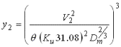
The approach to developing live bed contraction scour equations is very similar among all researchers and differs primarily by the method of determining the sediment transport capacity. Table 9 shows a summary of the exponents of the ratios common to the equations developed by other researchers. There is good consistency in the exponents, considering that each researcher used a different sediment transport equation. In the derivation of the live bed contraction scour equations, the sediment transport equation is applied to both the contracted and uncontracted sections, and only the difference in the transport rates between these sections affects the computed depth of scour. Thus, the depth of contraction scour does not appear to be sensitive to the selection of the transport equation. The discharge in the contracted and uncontracted sections is typically determined using a one-dimensional step-backwater computer model such as Water-Surface Profile Computations (WSPRO)(89) or Hydrologic Engineering Center-River Analysis System (HEC‑RAS).(90) Stream-tube and one-dimensional models distribute the flow in a cross section based on conveyance. The flow distribution in a contracted opening is more dependent upon momentum than on roughness, making conveyance-based flow distributions inaccurate. Experience in applying backwater models indicates that distribution of the flow by conveyance may lead to overestimating the depth of contraction scour. At the uncontracted approach cross section, a conveyance-based flow distribution may place more flow in the floodplain than what actually was present, resulting in the main channel's being too low. Increased flow in the floodplain can result because: (1) the one-dimensional model assumes a constant slope for the whole cross section when, in reality, the downstream water-surface slope varies across the section; (2) the one-dimensional model does not account for flow-path lengths between main channel and the floodplains; and (3) the one-dimensional model does not account for the lateral resistance of the flow moving from the main channel to the floodplains. Conversely, the conveyance-based flow distribution may place too much flow in the main channel at the bridge because the conveyance tubes fail to represent the accelerating curvilinear flow separating from abutments and (or) road embankments. A reduction of the main channel flow in the uncontracted section coupled with an increase of main channel flow at the bridge section could lead to an overprediction of depth of contraction scour. Clear Water Contraction Scour Equations Clear water scour occurs where the boundary shear stress in the uncontracted section is less than or equal to the critical tractive force of the bed material, thus, preventing the supply of material into the contracted section. Laursen assumed that the maximum limit of clear water scour occurs when the boundary shear stress is equal to the critical tractive force.(91) This assumption is common among all of the proposed clear water contraction equations. The critical shear stress of a channel with a specific grain size is commonly estimated from the Shields diagram. The critical velocity for incipient motion can be computed from the Shields parameter by substituting the Manning equation for the slope term of the shear-stress equation and then using Strickler to approximate Manning's n.(92) A critical velocity equation (equation 3) can be obtained by rearranging terms and solving for velocity. By setting the velocity in the contracted section equal to the critical velocity and solving for depth, the following generic clear water contraction scour is obtained:
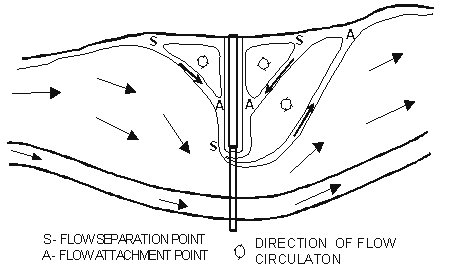
where V2 is the average velocity in the contracted opening in meters per second; and Dm is the mean grain size of the bed material, in meters. On the basis of research on the effective size of bed material for riprap design and resistance to erosion presented in Richardson et al.,(93) Richardson and Richardson suggest that 1.25 D50 be used for Dm.(84) The adequate determination of the critical velocity or critical shear stress and the corresponding scour is not well established for channels having cohesive bed material, bed material that varies with depth, heavily vegetated floodplains, previously developed scour holes, and armored beds. Laursen, Neill, White, Iwagaki, and Shields have all developed clear water scour relations, but all are based on assumptions that tend to oversimplify the conditions present in most field situations. (See references 94, 91, 95, 96, and 97.) The clear water scour equations were developed for flat beds, but only after a scour hole develops the hydraulics change, affecting the accuracy of the prediction equations. Proper representation of bed material is also critical to the application of clear water scour equations. Bed material samples should represent both the surface and subsurface material. Clear water contraction equations can be applied to each consecutive layer at sites where layered soils are present by modifying parameters as each layer is eroded and the next is exposed. Until recently, the effects of armoring were not accounted for in determining the depth of scour. Froehlich(98) presented a method based on the active-layer approach by Borah(99) to estimate the depth of scour required to obtain an armor layer of sufficient size and thickness to limit clear water scour. Abutment ScourThe current knowledge of prediction of scour at abutments is derived from regime theory equations, equations used to estimate the depth of scour for spur dikes, and equations developed from small-scale physical model studies conducted in laboratory flumes. Unfortunately, none of these approaches have resulted in a satisfactory prediction equation. These approaches' inability to accurately predict scour at abutments is a result of the simplifying assumptions on which the research is based and the complexity of abutment scour in field conditions. The configuration of bridge abutments and associated embankments is complex when placed in the context of river hydraulics. Field Conditions The geometric configuration greatly affects the way flow is directed around the abutments. The abutment may be located in the channel, at or near the top bank, or on the floodplain. The configuration of the abutment may be vertical, have wing walls at various angles, or have a spill slope protected with riprap or some other armoring material. Although abutments with spill slopes are usually protected, the armoring can fail or be undermined by scour causing the abutment configuration to change during a flood. The embankments may not be perpendicular to the approach flow but may be angled either upstream or downstream. Drainage ditches along the toe of the embankment are common and complicate the flow patterns around the abutment. The natural flow distribution in a river can also have a significant effect on the depth of scour at an abutment. The distribution of the approach flow blocked by the embankment is dependent on the roughness and topography of the floodplain and alignment of the main channel. The flow distribution and direction can change significantly during a flood hydrograph. Such complexity and the variability of these conditions between sites are major obstacles in developing a reliable method for predicting scour at abutments. Discussion of Equations Some abutment scour equations are based on data for scour at the end of spur dikes. The most notable equation of this type was published by Richardson and Huber as an equation for predicting scour when the embankment length to flow depth ratio exceeds 25.(100) This equation uses only the Froude number and depth of flow and does not account for the length of the embankment. Most equations for predicting scour at abutments are based on small-scale physical model studies. Literature documenting the laboratory experiments reveals that the approach section of the flume usually had a constant depth with a uniform velocity distribution. The roughness of the channel was also typically uniform throughout the approach and bridge sections, and the bed material was generally composed of uniform sand. The abutments were represented by solid, nonerodible obstructions protruding from the sides of the flume with ends that varied in configuration to represent typical shapes of embankments and abutments at contracted bridge openings. These conditions are different from the conditions that occur in the field. Several researchers have attempted to account for some conditions commonly found in the field. Dongol, Melville, and Sturm and Janjua have used models that incorporate the floodplain, some channel geometry effects, and nonuniform flow distributions.(101,102,103) Unfortunately, the amount of field data on abutment scour that can be used to evaluate the validity of the laboratory studies is limited. The laboratory research, although not in agreement, has typically used some combination of the following variables to predict scour at abutments: (1) embankment length, (2) abutment shape, (3) depth of flow, (4) velocity, and (5) discharge. Because of the simplicity of many of the laboratory experiments, the variables in equations developed from these experiments are ambiguous when these equations are applied to field conditions. In simple flume studies, the flow depth is uniform everywhere, and there is no way to define what depth is controlling the depth of scour (the depth at the abutment, the depth in the approach upstream of the abutment, or an average depth of flow blocked by the abutment). In the field, these may all be different values; however, in the laboratory with a uniform bed they are all the same. The velocity term is also a good example of potential ambiguous variables in the field. The velocity in the contracted opening adjacent to the abutment (which would represent the accelerated curvilinear flow) would be different from the unobstructed approach velocity upstream of the abutment or the average velocity of the approach flow blocked by the length of the embankment. Flume studies often use the total length of the embankment from the flume wall to the abutment as the embankment length; however, this approach fails to account for the flow separation and recirculation zone that forms along the upstream edge of the embankment (figure 30). The effective length of the embankment on the depth of scour depends on the distribution of the approach flow and the floodplain roughness and geometry. It is important that laboratory research emulate the conditions in the field so that equations developed are representative of field conditions.
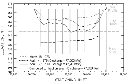
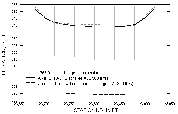
EVALUATION OF PUBLISHED FIELD OBSERVATIONSGeneralNumerous papers and reports have been written on the various aspects of scour at bridges; however, complete and reliable field data are rare. Table 10 summarizes a literature survey that yielded 29 references that might have contained field data for abutment and contraction scour. A brief summary of selected references is presented. Summary of Selected ReferencesResearch on backwater and discharge computations at single and multiple bridge openings, at bridges with openings that have been excavated, and at bridges with guide banks provided data at 60 bridges. (See references 81, 104, 105, 106, 107, and 108.) These data were collected at sites with heavily vegetated floodplains where complete real-time detailed data sets would be difficult to collect. The USGS, Mississippi District, has summarized data for two of the sites (figures 31 and 32) and made comparisons with computations based on contraction scour equations recommended in HEC-18.(109) Lithologic logs available for the site at Edinburg, MS, clearly showed the elevation of a hard clay layer (figure 31).No detailed bed material data were available for the site at Burnside, MS (figure 32); however, attempts to collect a sample of surface bed material indicate a hard surface; small amounts of clay were recovered. Table 10. Summary of published field data for contraction and abutment scour.
A—additional analysis required G—general observations C—comparison with computed scour included
Norman presented detailed data and analyses of seven sites in Alaska; these are the most detailed and complete data sets available in the literature.(16) These data include concurrent measurements of uncontracted and contracted sections during floods, bed material data, velocity data, and detailed discussions of the site and data collection procedures. The local scour portions of these data are included in the national bridge scour database.(21,22) A summary table for the three sites with contraction scour measurements and a comparison with computed values of mean depth in the contracted section is presented in table 11.
Fischer presented post-flood analysis data on contraction scour occurring at S.R. 2 over the Weldon River in south-central Iowa.(17) The bridge is 68 m long and is supported by two monolithic piers and spill-through abutments. The area consists of rolling hills that surround a wide river valley with a floodplain width of 670 m at the site. Bed material at the site consists of banks of sandy, silty clay with sand and occasional boulders in the streambed underlain by glacial clay. The peak discharge of 1,930 m3/s was determined by a combined contracted-opening and road-overflow measurement of peak discharge using the techniques outlined by Matthai and Hulsing.(80,126) The estimated peak discharge was about four times the 100-year design flood. High-water marks indicated that the water-surface fall through the bridge was 1.45 m; the depth of flow over the roadway was about 0.8 m. Bed profiles measured along the upstream and downstream edges of the bridge after the flood showed that the spill-through slope at the left abutment was scoured about 4 m to approximately the top of the glacial clay. The main channel portion of the bridge did not show appreciable scour when compared to the cross section from the construction plans; however, the bed elevation was very close to the upper limit of the glacial clay and may have refilled with sand before the post-flood measurements. The average velocity through the submerged bridge opening was estimated to be 3.0 m/s at the peak, but it was likely greater when the entire discharge passed through the bridge before overtopping. Downed trees, sand deposition on the floodplain, cobble deposition in the main channel, and eroded banks were evidence of the high velocity that passed through the bridge. None of these characteristics were observed upstream of the bridge. Holnbeck et al. presented a case study of contraction and abutment scour at U.S. 87 over Razor Creek in Musselshell County, MT.(18) Razor Creek is an ephemeral stream with a drainage area of 44.3 km2. The bridge, constructed in 1955 and recently replaced, had a span of 22.9 m with two timber-pile bents at 7.6-m spacing. The streambed has a sand and gravel layer ranging in thickness from 1.2 to about 4.4 m, and a grain size distribution of D10, 0.065 mm; D50, 2 mm; and D90, 20 mm. Very dense, tan sandstone and weathered shale underlie the sand and gravel to a depth of at least 10.7 m. Peak discharges at the bridge resulting from thunderstorms in July 1986 and June 1991 were estimated by the USGS using the width-contraction, indirect measurement method.(80) These two floods are believed to be about three and four times the estimated 100-year peak discharge, respectively. Contraction scour is probably not significant at this site for floods less than the 1991 flood because the indirect measurement of the 1986 peak discharge indicated no water-surface drop through the bridge, but a water-surface drop of 2.4 m was observed for the 1991 flood. The components of total scour were computed from hydraulics estimated from a WSPRO model using the Laursen live bed contraction scour equation, the Froehlich live bed abutment scour equation, and the HEC-18 pier scour equation (table 12). The observed scour at the abutments included loss of riprap that had been placed before the 1991 flood, which may have reduced the depth of scour. The presence of sandstone in the area near the right abutment may have also limited scour depth in that area. Table 12. Comparison of computed and measured scour at U.S. 87 on Razor Creek, MT, June 1991 (modified from Holnbeck et al.(18)).
Brabets presented an analysis of scour at 12 bridges located along the Copper River Highway from Flag Point to the Million Dollar Bridge in Alaska.(117) The lower Copper River is a complex and dynamic river system. The bridges analyzed are over distributary channels in the approximately 777-km2 delta, and these channels constantly scour and fill, causing lateral channel migration. The bed material at bridges 331 and 1187 is medium gravel. Spur dikes were constructed at the left upstream abutment of bridge 331 and at both upstream abutments of bridge 1187. An approach section surveyed in May 1992 at each bridge was used to evaluate the contraction scour at this site (table 13). Table 13. Measured and predicted mean depth of flow at bridges 331 and 1187 on the Copper River Highway, Alaska, in May 1992 (modified from Brabets(117)).
Fischer presented a case study of scour caused by flooding in September 1992 at S.R. 14 over Wolf Creek in Iowa.(118) The bridge is a 30.5-m single-span steel structure supported by vertical wall concrete abutments with wingwalls. The floodplain is primarily agricultural and is approximately 400 m wide near the bridge. Dense woods line both the upstream and downstream sides of the highway near the bridge. Along the right upstream floodplain is woody riparian vegetation along the stream; pasture sits further back on the floodplain. The estimated peak discharge of 2,200 m3/s was determined based on high-water marks and modeling of the flow using WSPRO. Fischer evaluated gravel deposits left when the road was overtopped and estimated the fall through the bridge at incipient road overtopping was 3.4 m.(118) The hydraulic analyses indicated that the flow may have been supercritical through the bridge opening at that time. The water-surface elevation continued to rise following the overtopping and completely submerged the bridge section; the fall through the bridge was reduced to 1.94 m. Information from the highway department indicates that backwater caused by channel constrictions downstream eventually reduced the fall to about 0.3 m and eventually submerged the bridge section. Using the streambed profile from the 1946 bridge plans as a reference, estimates were that 6 m of contraction scour occurred during this event. Using the methods outlined in Richardson et al., the depth of contraction scour was computed to be 9.1 m.(59) A pond about 75 m long and 50 m wide downstream of the bridge remained after the flood had receded. This large area was scoured by the high-velocity flow exiting the contracted opening. Hayes analyzed records at gauging stations in Virginia and Maryland and identified four sites with contraction scour.(122) Routine streamflow measurements do not contain an approach-and-exit section to use as a reference surface. Hayes analyzed bed-elevation trends in the record and selected only stations where no long-term trends were present; he used the cross section geometry that existed before the bridge was constructed as the reference surface for these stable sites. Each site was visited and the appropriate cross sections surveyed and bed material samples collected. WSRPO was used to model the hydraulics at each site to allow computation of contraction scour according to the procedures recommended by Richardson and Davis.(6) Table 14 presents the data and computed depths of contraction scour. The sites on Big Pipe Creek and the Northeast Branch Anacostia River are coarse bed material streams with a D50 of about 20 mm. The other two sites are sand bed streams. It can be seen from the results in table 14 that the equations frequently underestimate, and no gross overestimation of scour occurred. Table 14. Comparison of measured mean depth to calculated mean depth at bridges where contraction was present during flood flows (modified from Hayes(122)).
Jackson presented field data and associated analysis for sites in Ohio that were originally selected to minimize contraction and focus on pier scour; thus, contraction scour was only observed at three sites.(42) Data were collected from the bridge deck, so no concurrent approach-and-exit sections were measured. Jackson assessed the stability of the streambed elevation and concluded that the streambed was relatively stable and that use of the low-water approach-and-exit sections as the reference surface did not introduce significant error (less than 0.2 m). The data are presented in table 15, but no comparison with computed scour was presented. Table 15. Contraction scour data published by Jackson.(42)
Benedict and Caldwell presented an interim summary of a study to measure and analyze the characteristics of clear water scour at bridges in the Coastal Plain and Piedmont areas of South Carolina.(124) The data are being collected during low water and reflect the maximum scour resulting from all historical floods at a given site. Field data collection techniques allow the identification and adjustment of scour depths for any infilling that may have occurred. Although no real-time hydraulic data are being collected, the investigators plan to use WSPRO to model and compare the measured scour depths with computed depths of scour obtained by applying the methods recommended in Richardson and Davis.(6) The Coastal Plain, which comprises about 63 percent of South Carolina, is characterized by thick sand deposits, relatively flat stream slopes (0.0002 to 0.004 m/m), and heavily vegetated floodplains. The lower Coastal Plain contains many swamps that have a heavily vegetated floodplain drained by a network of shallow, poorly defined channels. The root masses of the vegetation significantly impede the transport of bed sediments, thus creating clear water scour at bridge contractions. The typical scour hole at sites with smaller bridges (bridge length of 61 m or less) was observed to develop as a single, long, and deeply cut channel extending from just upstream of the bridge to as much as 60 m downstream. Flows from around the left and right abutments overlap, and scour is concentrated near the middle of the bridge. As the bridge length increases, the observed pattern of scour changes to two separately cut holes near the abutments. The patterns described are common, but the scour patterns vary depending upon site-specific conditions. The maximum clear water scour observed at 63 sites in the Coastal Plain ranged from 0.4 to 7.2 m. The Piedmont represents about 35 percent of South Carolina; it is characterized by clayey soils, moderately steep stream slopes (0.001 to 0.01 m/m), and incised channels on heavily vegetated floodplains. Clear water contraction and abutment scour occurs where the abutments are set back from the main channel and the embankments contract the flow in the floodplain. The typical clear water contraction scour pattern on an overbank is a shallow swale running parallel with and directly under the bridge. The typical clear water abutment scour pattern is a shallow swale oriented upstream to downstream near the abutment toe. Deviation from these patterns is infrequent where the soils are predominantly clay. The maximum clear water scour observed at 47 sites in the Piedmont range from 0 to 1.4 m. Although sandy floodplains are rare in the Piedmont, the clayey soils at some sites have a high sand content. These sites typically have wide floodplains with a pronounced contraction at the bridge. The maximum clear water scour observed at 18 Piedmont sites with sandy floodplains ranges from 0.9 to 5.5 m. The summary of data presented by Benedict and Caldwell provides field validation of concepts commonly accepted, but previously not documented by field data.(124) The paper does not present any of the raw data, as the analysis of these data is ongoing by the USGS, South Carolina District. The results of the project will provide valuable field-based insight into clear water scour processes and will inform a substantial database for future research. Of the 29 references, only Norman presented detailed data collected during floods.(16) Nearly all of the sites presented in the literature would require the compilation of the raw data and additional analysis to obtain complete abutment and contraction scour data sets. Only two references included data on abutment scour.(18,118)Seven papers presented data on contraction scour, and 14 discussed sites that could yield contraction scour data if additional data were available to supplement the limited data presented in the papers. The comparison of field data with computed scour showed mixed results. Papers by Norman, Holnbeck et al., Brabets, and Fischer showed that the contraction scour equations typically overpredicted the observed scour and in a few instances, severely overpredicted the scour. (See references 16, 18, 117, and 118.) The paper by Hayes showed that the Laursen contraction scour equation underpredicted a number of measurements, and no severe overprediction was present.(122) The accuracy of the contraction scour equation may depend greatly upon the degree of contraction, the flow distribution, the configuration of the approach, and how well the hydraulic model represents the true flow distribution. | |||||||||||||||||||||||||||||||||||||||||||||||||||||||||||||||||||||||||||||||||||||||||||||||||||||||||||||||||||||||||||||||||||||||||||||||||||||||||||||||||||||||||||||||||||||||||||||||||||||||||||||||||||||||||||||||||||||||||||||||||||||||||||||||||||||||||||||||||||||||||||||||||||||||||||||||||||||||||||||||||||||||||||||||||||||||||||||||||||||||||||||||||||||||||||||||||||||||||||||||||||||||||||||||||||||||||||||||||||||||||||||||||||||||||||||||||||||||||||||||||||||||||||||||||||||||||||||||||||||||||||||||||||||||||||||||||||