U.S. Department of Transportation
Federal Highway Administration
1200 New Jersey Avenue, SE
Washington, DC 20590
202-366-4000
Federal Highway Administration Research and Technology
Coordinating, Developing, and Delivering Highway Transportation Innovations
 |
| This report is an archived publication and may contain dated technical, contact, and link information |
| breadcrumb |
Publication Number: FHWA-HRT-04-079
Date: July 2006 |
||||||||||||||||||||||||||||||||||||||||||||||||||||||||||||||||||||||||||||||||||||||||||||||||||||||||||||||||||||||||||||||||||||||||||||||||||||||||||||||||||||||||||||||||||||||||||||||||||||||||||||||||||||||||||||||||||||||||||||||||||||||||||||||||||||||||||||||||||||||||||||||||||||||||||||||||||||||||||||||||||||||||||||||||||||||||||||||||||||||||||||||||||||||||||||||||||||||||||||||||||||||||||||||||||||||||||||||||||||||||||||||||||||||||||||||||||||||||||||||||||||||||||||||||||||||||||||||||||||||||||||||||||||||||||||||||||||||||||||||||||||||||||||||||||||||||||||||||||||||||||||||||||||||||||||||||||||||||||||||||||||||||||||||||||||||||||||||||||||||||||||||||||||||||||||||||||||||||||||||||||||||||||||||||||||||||||||||||||||||||||||||||||||||||||||||||||||||||||||||||||||||||||||||||||||||||||||||||||||||||||||||||||||||||||||||||||||||||||||||||||||||||||||||||||||||||||||
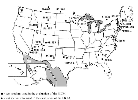
Seasonal Variations in The Moduli of Unbound Pavement LayersChapter 3: Data Acquisition and AssessmentINTRODUCTIONAs indicated previously, this investigation used data obtained via the LTPP Seasonal Monitoring Program. This chapter provides information regarding the LTPP data that were used, as well as the data manipulation and assessment that were conducted prior to application of the data in model evaluation and development. In addition, information on the variability observed in the data is presented to provide context for evaluating the outcome of the work presented in Chapters 4 through 6. DATA SOURCESThe locations of the LTPP seasonal monitoring test sections considered here are shown in Figure 2. In the figure, square symbols designate test sections used in the evaluation of the EICM, discussed in Chapter 4. All sections shown in the figure were used in the development of predictive models for backcalculated pavement layer moduli, discussed in Chapter 5. The layer thickness ranges for these test sections are summarized in Table 18, while the distribution of soil classifications for the test sections is summarized in Table 19. While the more fine-grained subgrade soil classifications are relatively scarce, the test sections represent a reasonably broad array of conditions.
The data used in the analyses presented herein are drawn from DataPave 2.0, except as follows: [72]
The review, manipulation, and processing of these data prior their application are discussed in the remainder of this chapter. BACKCALCULATED MODULIBackcalculated layer modulus is the key dependent variable considered in this investigation. The first subsection of this chapter provides an overview of the process used in the backcalculation of those layer moduli. Subsequent subsections discuss the evaluation of those moduli and findings with regard to the variability in the backcalculated moduli. Backcalculation of Pavement Layer ModuliThe backcalculated pavement layer moduli used in this investigation were derived through a separate study by Von Quintus and Simpson.[73] The backcalculated layer moduli considered in this investigation were provided to the author prior to detailed review or the application of the quality control checks ordinarily applied prior to the release of data from the LTPP database. The author’s evaluation of the backcalculation results to assess their adequacy for use in this study are discussed below. Figure 2. Locations of LTPP seasonal monitoring sections considered in this study
Evaluation of Backcalculated Layer ModuliAs noted in Chapter 2, one complicating factor in the backcalculation of pavement layer moduli from deflection data is that there is no closed-form solution to the problem. For any given set of measured load and deflections, layer thicknesses, and Poisson’s ratios (the input to the backcalculation process), there may be several, sets of "matching" layer moduli. It is therefore incumbent upon the engineer to carefully evaluate the output of the backcalculation process to determine whether the moduli determined through that process are in fact plausible for the set of circumstances surrounding the collection of the deflection data. Absolute judgments as to the accuracy of any given set of backcalculated moduli are impossible to make, as the true values are never known. Furthermore, the acceptability of a given set of backcalculated moduli depends to some degree on the intended application. Prior to being used in subsequent analysis, the backcalculated moduli were evaluated against several criteria. First, the moduli were subjected the following series of objective checks.
As with the range checks, all layer moduli associated with a given set of deflection data were treated as a set. Sets of moduli judged to be implausible were flagged as such, so that they could be excluded from analysis sets, but were not deleted from the database. Data reflecting consistent behavior that differed from expectations (e.g., consistent load-softening in a material classified as granular) were not flagged unless there was some other reason to consider them suspect. Variation in Moduli Under Nonfrozen ConditionsFollowing the evaluation discussed in the previous section, an exploratory analysis of the backcalculated moduli and their inherent variation was undertaken. The purpose of this analysis was twofold:
The findings of that work are discussed in the next few sections. Variation with FWD Load The extent to which the backcalculated moduli vary with FWD load level is characterized in Table 21. This table presents the mean layer moduli for the nominal 40-kN and 71-kN FWD loads, and the mean difference between them, for each AASHTO soil class represented in the data set. The statistics in this table indicate that the A-1-a, A-1-b, and A-2-4 soils tend to be load hardening, whereas the A-2-6, A-3, A-4, and A-6 soils tend to be load softening. The observed trends for the A-1-a, A-1-b, A-4, and A-6 soils are consistent with expectations, and the load softening of the A-2-6 is not unexpected, in light of the clay component in these materials. However, the load softening of the A-3 soils is not consistent with expectations. Rather, one would expect these granular materials to be load hardening. Statistics for the individual pavement layers considered in the computation of the A-3 soil class statistics in Table 21 are presented in Table 22. Possible explanations for the unexpected trends are offered in the next paragraphs. The variation in the A-3 subgrade soils at sections 251002 and 271018 is very small, and is therefore attributed to errors in the backcalculated moduli, rather than true load-softening behavior. At sections 271018 and 276251, the moduli for the upper portion of the A-3 subgrade exhibit the expected load hardening behavior, whereas those for the lower portion exhibit a lesser degree of load softening. It is likely that this is attributable, at least in part, to compensating error effects.
The load-softening behavior of the subgrade (layer 3 and 4) soil at section 351112 is attributed to the presence of fine-grained soils in the deeper subgrade strata. The soils, characterized in the boring log for the section as sandy clay, silty clay, and clayey silt, are below the depth at which samples were obtained for the laboratory characterization.
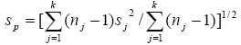
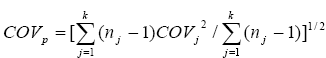
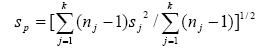
Within-Day Variations For a given nominal test location and FWD load level, within-day variations in backcalculated moduli for unbound pavement layers may occur as a result of both true within-day changes in the in situ moduli (arising from stress-state changes induced by temperature-related changes in the stiffness of an overlying AC layer, for example), or as a result of variations (errors) in the deflection testing and backcalculation process. The latter would include variations due to 4 5deflection and load-measurement errors, variations in placement of the FWD relative to the nominal test point, variations in FWD load from the nominal values, and backcalculation errors. The magnitude of the observed within-day variations in the backcalculated moduli is characterized in Table 23. The statistics presented in this table are pooled values, computed in accordance with American Society for Testing and Materials (ASTM) standard E122. The pertinent equations are Equations 23 and 24:
and
In computing these statistics, the individual sj values represent the within-day standard deviation for a particular section, test point, nominal FWD load level, and layer, and nj is the number of individual observations associated with that value. The values presented in Table 23 are pooled over all test points, sections, layers, and nominal FWD load levels for the soil class or layer type indicated. Thus, in this table k is the number of combinations of date, test section, test point, layer, and FWD load level for a given soil class or layer type. In most cases, the variation in variability statistics with nominal FWD load level is small in comparison to the variation between the different layers. For example, the COV for section 091803), layer 2 varies in the range of 18 to 20 percent, whereas that for layer 3 varies in the range of 5 to 7 percent. Also, for the many of the pavement sections (e.g., 040113, 041024, 091803, 131005, 251002, 271018, 351112, 481077, 491001, 561007, and 871622), the base layer (layer 2) is more variable than either the subbase/upper subgrade (layer 3) or the subgrade/lower subgrade (layer 4), independent of the measure (standard deviation or coefficient of variation) considered. This may occur as an artifact of the testing and backcalculation process, or it may come about as a result of within-day variations in the stress state within the pavement structure arising from variations in the temperature (and therefore stiffness) of the AC surface layer. The author believes that both factors contribute to the observed variation.
Section 501002 is one pavement for which the variability of the upper subgrade is greater than that of the base whether one considers the standard deviation or the COV. Both the base and subgrade at this section are classified as A-1-a soils, such that the true in situ moduli may be very similar. If this is, in fact, the case, the similarity will be reflected in the measured deflections, and it will be difficult to distinguish between the two in the backcalculation process. Thus, the fact that the upper subgrade at this section appears to be more variable than the base may be attributable to the similarity of the materials—i.e., a spurious result. The magnitude of variation for the more coarse-grained soils (A-1-a, A-1-b, and A-2-4) is consistently greater than that for the more fine-grained soils. However, the author believes that this occurrence is primarily attributable to the predominant use of the coarse-grained soils as base material, whereas the more fine-grained materials are generally seen only in the subgrade. That is, the extent of variability in the backcalculated moduli is driven more by the location of the soil in the pavement structure than by the grain-size distribution of the soil. This interpretation is supported by the data presented in Table 24, which presents within-day statistices pertaining to individual A-1-b pavement layers. The variation in the A-1-b base soils is generally (but not always) greater than that for the A-1-b subbase/subgrade soils.
Seasonal Variations The extent of seasonal variation in the moduli backcalculated for nonfrozen conditions is characterized in Table 25 and Table 26. Pavement layers for which the backcalculated moduli in the data set spanned less than 6 months were excluded in the computation of the statistics presented. For this reason, the means, minima, and maxima presented in Table 25 differ somewhat from those presented in Table 21, which considers all available pairs of data for the 40- and 71-kN load levels. The maxima and minima presented herein do not reflect the true maxima and minima occurring in all pavements because the data set has been restricted to frost-free conditions. The amplitude of the observed variation varies with the nominal FWD load level. For 67 percent of the individual layers considered, the amplitude of the observed variation decreases between the minimum and maximum FWD loads. However, the variation from one load level to the next is not always monotonic. Some differences may be attributable to differences in the time span considered. The interaction of stress and moisture may also be a factor in the observed differences. The lower subgrade for section 131031 is somewhat exceptional in that the amplitude of variation varies by only 1 MPa between load levels. The amplitude of the observed variation tends to be higher for the granular materials than it is for the more fine-grained materials. For example, in Table 25 it may be observed that the amplitude of variation for the A-1-a soil class varies in the range of 72 to 96 percent (depending on load level), whereas that for the A-4 soil class varies in the range of 53 to 63 percent. Similarly, in Table 26 it may be observed that the amplitude of variation decreases with increasing depth in the pavement, with the base layers being most variable on an absolute basis (152–168 MPa, compared with 57 to 76 MPa for subbase layers, and 8 to 88 MPa for subgrade layers). This observation is consistent with the findings of Newcomb et al. and Uhlmeyer et al.[62, 63] However, the subbase layers are more variable on a percentage basis (95 to 123 percent, compared with 90 to 101 percent for the base layers and 6 to 67 percent for the subgrade layers). It is hypothesized that the amplitude of variation (in absolute terms)tends to decrease with increasing depth because the observed seasonal variations are caused, in part, by changes in stress state arising from temperature-induced changes in the modulus of the overlying AC layer, and this effect is more pronounced for the layers closer to the pavement surface.
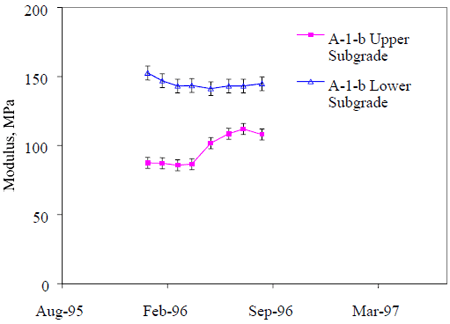
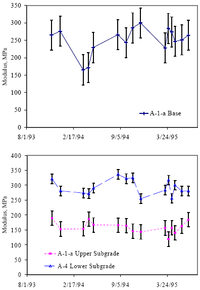
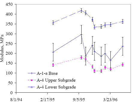
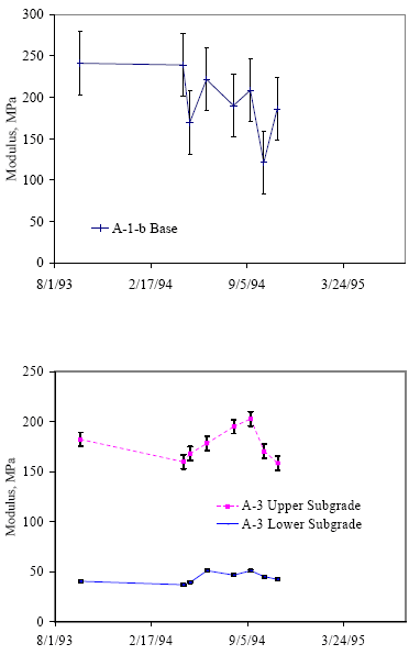
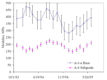
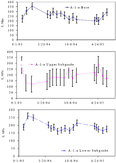
In the time variation in the backcalculated layer moduli at selected sections is illustrated in Figure 3 through figure 7. The moduli shown in these plots are daily average values for the nominal 53-kN FWD load, and the error limits shown in the plots are within-day standard deviations. In Figure 3, the observed variation with time for section 040113 (sited in Arizona) is negligible for the lower portion of the subgrade, and very modest for the upper portion of the subgrade and the base layer. Also, it may be noted that the magnitude of the seasonal variation is not much greater than the within-day variation illustrated by the error limits on the individual data points. Greater variability in all pavement layers is seen in Figure 4 through Figure 8. The subgrade data for sections 131005 (Georgia, Figure 5) and 481077 (Texas, Figure 7) follow a more-or-less sinusoidal trend. The variations for sections 091803 (Connecticut, Figure 4), 271018 (Minnesota, Figure 6) and 501002 (Vermont, Figure 8) are more difficult to characterize. The relationship between these variations and potential explanatory variables will be explored in Chapter 5. In summary, the single-point within-day variation in backcalculated moduli for unbound pavement layers, expressed in terms of the coefficient of variation, was found to vary in the range of 1 to 38 percent. Pooled values of 19, 14, and 11 percent were computed for the base, subbase, and subgrade layers, respectively. The amplitude of the observed seasonal variation (exclusive of frost effects) was found to vary in the range of 6 to 123 percent of the observed minimum value, corresponding to amplitudes of 8 to 173 MPa. In absolute terms, the largest variations were observed for the base layers, and the smallest variations were observed for the deeper subgrade layers. On a percentage basis, the subbase layers were more variable than the base layers, and both base and subbase layers were more variable than the deep subgrade layers. Figure 3. Seasonal variation in daily average moduli, section 040113 (Arizona)
Figure 4. Seasonal variations in daily average moduli, section 091803 (Connecticut)
Figure 5. Seasonal variations in daily average moduli, section 131005 (Georgia)
Figure 6. Seasonal variations in daily average moduli, section 271018 (Minnesota)
Figure 7. Seasonal variations in daily average layer moduli, section 481077 (Texas)
Figure 8. Seasonal variation in moduli, section 501002 (Vermont)
STRESS PARAMETERS Stress parameters considered in the development of predictive models for backcalculated moduli discussed in Chapter 5 were the bulk stress (? = s1 + s2 + s3), and the octahedral shear stress (toct = 1/3[(s1-s2 )2 + [(s2-s3 )2 (s3-s1 )2]½). Selection of the bulk and octahedral shear stresses was based on their prior use in the constitutive models discussed in Chapter 2. Stress parameters were computed for each individual set of backcalculated layer moduli considered in the analysis (where a"set" is defined by test section, date, time, test point, and FWD load). Stresses were computed for a single radial location, that being the center of the loaded area. The depths at which the stresses were computed corresponded to the quarterpoints for each finite layer, and 0.1, 0.2, and 0.3 m below the layer interface for semi-infinite subgrade layers. In calculating the stress parameters, both load-induced and overburden stresses were considered. The load-induced stresses were computed through application of the CHEVLAY 2 layered–elastic analysis program to the backcalculated layer moduli.[26] To ensure consistency, the layer thicknesses and Poisson’ s ratios used in the stress calculations were those reported with the backcalculated moduli. The calculation of overburden stresses took into consideration variations in total (wet) soil density with time due to fluctuations in moisture content, as well as variations in the depth of the water table. Effective stresses were used for soils below the water table, while total stresses were used for soils above the water table. Several different values of K0 were considered in the overburden computations, as will be discussed in Chapter 5. MOISTURE PARAMETERSAt each LTPP Seasonal Monitoring Program test section, moisture content is monitored through the use of Time Domain Reflectometry (TDR) probes placed at approximately 10 depths in the unbound base, subbase (if present), and subgrade layers. The number of monitoring depths within a given layer at a particular section varies from one to five, depending on the layer thicknesses at that particular section. The number of observations for a given probe on a given test date varies from one to three. TDR is an indirect method of monitoring moisture. The raw data collected with the TDR instrumentation are interpreted to determine the dielectric constants (Ka) for the soil. The volumetric moisture content is then computed using regression equations relating the dielectric constant (and possibly other soil parameters) to moisture content. Knowledge of the soil dry density allows computation of the gravimetric moisture content. The specifics of the methodology as applied to the LTPP Seasonal Monitoring Program sections are presented elsewhere.[75,76,77] Both volumetric and gravimetric moisture contents are provided in the LTPP database. The work reported herein utilized the volumetric moisture contents. Four different regression models were used in determining the moisture contents for the LTPP seasonal monitoring sections. The models are presented in Table 27. The conditions of application for each of the four models, as well as the minimum and maximum estimated errors (for 95 percent confidence limits) in the TDR moisture contents are summarized inTable 28. Note that the magnitude of the estimated error varies with the dielectric constant, and, thus, with the moisture content. The vast majority of the data considered in this investigation were derived using the Coarse Ka Model (TDR Model 1). TDR Model 2 was used only for the deeper (subgrade soil) probes at sections 308129, 481068 and 871622. TDR Model 3 was used for many observations in the subgrade soil at section 501002, and for some data sets at other sections. TDR Model 4 wasused only at sections 481077, 481068, 241634, and 081053. The volumetric moisture data were reviewed through plots of the mean moisture content as a function of time, analysis of the within–day variation reflected in the data, and comparison of day–of–installation TDR moisture contents with laboratory values for samples collected fromthe backfill material as the probes were installed.
The within–day variation for the TDR moisture data is characterized in Table 55 of Appendix A. The values shown are pooled values, computed in accordance with ASTM standard E122. The pertinent equation is:
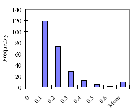
For each combination of test section and TDR probe, n is the number of moisture observations in a given day, and k is the number of days for which moisture data are available for that probe. The number of test dates considered in the computation of the within day variation statistics is presented in Table 56 (Appendix A), while the average number of observations per day is presented in Table 57 (Appendix A). The pooled standard deviation and coefficient of variation computed over all moisture observations (i.e., k = number of combinations of monitoring date test, section, and TDR probe) are 1.18 and 8.8 percent, respectively. The prediction error limits presented in Table 28 provide a frame of reference for evaluating the magnitude of the within-day variations in TDR monitored moisture, as characterized by the pooled standard deviation. In Table 58 (Appendix A), the pooled standard deviation for each probe is expressed as a decimal fraction of the maximum estimated error for TDR Model 1 from Table 28 – that is, 5.4. A single value was used for all TDR probes for simplicity. The value for TDR Model 1 was selected because it was used in the computation of the vast majority of the moisture data, and because it is conservative in comparison to the maximum values for the other TDR moisture models. The TDR moisture error estimates presented in Table 28 are computed as twice the standard error of the prediction. Thus, Table 58 (Appendix A) values greater than 0.5 indicate that the within-day standard deviation is greater than the estimated standard error of the prediction. Ratios greater than 0.5 are denoted in the table by gray shading. They occur for most of the probes for section 481068 and one probe each for sections 040113, 161010, and 308129. The data in Table 58 (Appendix A) are summarized in the form of a frequency histogram in Figure 9. Values in the range of 0.1 to 0.3 occur with the greatest frequency, indicating that in most cases, the within-day standard deviation is small in comparison to the estimated model error. Individual observations for the within-day standard were evaluated by comparing them to the overall pooled within-day standard deviation of 1.18. In cases where the within-day standard deviation for a given date and probe depth exceeded three times the pooled within-day standard deviation computed over all sections, the individual observations for that probe and test date were reviewed in an attempt to ascertain whether the high variance could be attributed to anything other than random error in the measurement process. The data sets identified for examination are listed in Table 59. They include observations associated with the high pooled within-day standard deviation values denoted by shading in Table 58. The findings of the review of these data were as follows. Figure 9. Frequency histogram for ratio of within-day standard deviation/ maximum TDR Model 1 error
Within-Day Standard Deviation/Prediction Error
In the remaining instances where the within-day standard deviation for a given section and test date exceeded three times the overall pooled within-day standard deviation, no plausible explanation for the observed variation was identified. That is, there was neither a clear indication that the data were erroneous, nor any indication of conditions likely to cause a within-day moisture content change of the magnitude reflected in the data. It was therefore assumed that the observed variance was attributable to random variation in the measurement processes, and that exclusion of these data from the analysis was not justified. The observed within-day variation in moisture content reflects both true within-day changes in moisture content and variability arising from measurement errors. Because the observed values are, in most cases, small in comparison to the estimated error associated with the measurement technology used, as characterized in Table 28, it is reasonable to assume that within-day variation in the true moisture content of the soil surrounding a given TDR probe is small in comparison to the measurement error associated with the moisture content data. Therefore, the best available estimate of the in situ moisture content at a given time is the daily mean value for the test date in question. For this reason, and because a one-to-one correspondence between the time of TDR moisture observations and the time of FWD deflection tests does not exist, the analyses reported herein use the mean daily moisture content for a given test date, rather than the individual observations. INPUT TO THE INTEGRATED CLIMATIC MODELApplication of the EICM requires assembly of a data set characterizing the pavement crosssection, materials, and external environment. The broad categories of input data required by the EICM are as follows.
In applying the EICM, the author used section-specific data where they were available and pertinent to moisture prediction. However, some required data elements are not among the data assembled for the LTPP test sections. Default or assumed values were used for these parameters. Default or assumed values were also used for a few parameters (e.g., AC mix design information) not pertinent to moisture prediction as a matter of convenience. The following paragraphs provide an overview of the data that were used in applying the EICM. The data themselves (including assumed or default values) are presented in Appendix B. Details that varied from one version of the EICM to another are discussed in the pertinent sections of Chapter 4. Climatic Boundary ConditionsDaily temperature and rainfall data (including the times at which the daily maximum and minimum temperature occurred), and (nominally) monthly depth to ground water data collected at each section for the time period of the simulation were used in the models. Windspeed and percent sunshine data used were those provided with the EICM for the weather stations identified in Table 60 to Table 64 of Appendix B, as these data are not collected at the seasonal monitoring sections. The recommended default values were used for the remaining variables. Missing observations were filled in through use of the "generate" function of the EICM, except as discussed in the next two paragraphs. In a few instances, missing water table depth observations were accompanied by comments to the effect that the monitoring well was dry. Where this occurred, a depth to water table slightly greater than the depth of the bottom of the monitoring well was entered. This estimate is deemed more accurate than allowing the program to generate a value by interpolating between known values, which would yield an estimate inconsistent with the observed (dry) state of the monitoring well. In one case, section 041024, the monitoring well was reported to be dry on all monitoring dates. For this section, a constant water table depth of 152 m (500 ft) was assumed. Infiltration and DrainageThe EICM requires entry of the linear length of cracks and joints for use in computation of the amount of water infiltrating the pavement. The values used in the simulation were estimated from the yearly mean distress quantities for the year considered in the simulation, distress surveys having been conducted on a quarterly basis. Because several distresses observed at the test sections considered are recorded in terms of the affected pavement area, as opposed to the crack length, it was necessary to convert the distress areas recorded in the LTPP database to equivalent crack lengths. Assumptions made to estimate the equivalent crack length for distresses measured in units of area are summarized in Table 29.
Asphalt Material PropertiesProgram default values were used for the asphalt materials, as it was assumed that these variables would have no impact on the predicted moisture contents for the unbound layers. Material PropertiesFor sections where multiple observations for a particular parameter were available, the ones used were those for sample locations closest to the location of the subsurface instrumentation. Default values were used for the saturated permeability, dry thermal conductivity, dry heat capacity, volume compressibility, and Gardner model parameters (Version 2.0 of the EICM only), as these parameters are not among the data available for the LTPP test sections. Assumed values were used for the frozen and unfrozen resilient modulus, Poisson’s ratio, and the length of the recovery period, as these parameters have no bearing on moisture predictions. Initial Temperature and Pore Pressure ProfileThe initial temperature profiles used in the EICM models were derived from section-specific data obtained with thermistor probes installed in the pavement. Linear interpolation was used to estimate the soil temperature at each node from the temperatures at the two closest monitoring depths. The pavement surface temperatures were extrapolated from the available data (measurements having been taken at mid-layer, and approximately 0.025 m below the surface, and 0.025 m above the lower boundary of the layer). Temperatures for the deepest model nodes were estimated. Daily average values were used in all cases. The initial pore pressure profiles used in applying Version 2.0 of the EICM were computed from the water table depth per the guidance provided in the EICM documentation.[66] Version 2.1 and subsequent versions of the EICM do not utilize an initial pore pressure profile. SUMMARYThe data required for this investigation include backcalculated pavement layer moduli (the key dependent variable), in situ moisture data, pavement cross-section and materials data, and climatic data. These data were acquired from the LTPP database, and (in some cases) off-line files, reviewed and manipulated to create the database and EICM input files necessary for the pursuit of the project objectives. The application of these data to evaluate the moisturepredictive capabilities of the EICM and develop predictive models for backcalculated pavement layer moduli will be discussed in the next two chapters.
|
||||||||||||||||||||||||||||||||||||||||||||||||||||||||||||||||||||||||||||||||||||||||||||||||||||||||||||||||||||||||||||||||||||||||||||||||||||||||||||||||||||||||||||||||||||||||||||||||||||||||||||||||||||||||||||||||||||||||||||||||||||||||||||||||||||||||||||||||||||||||||||||||||||||||||||||||||||||||||||||||||||||||||||||||||||||||||||||||||||||||||||||||||||||||||||||||||||||||||||||||||||||||||||||||||||||||||||||||||||||||||||||||||||||||||||||||||||||||||||||||||||||||||||||||||||||||||||||||||||||||||||||||||||||||||||||||||||||||||||||||||||||||||||||||||||||||||||||||||||||||||||||||||||||||||||||||||||||||||||||||||||||||||||||||||||||||||||||||||||||||||||||||||||||||||||||||||||||||||||||||||||||||||||||||||||||||||||||||||||||||||||||||||||||||||||||||||||||||||||||||||||||||||||||||||||||||||||||||||||||||||||||||||||||||||||||||||||||||||||||||||||||||||||||||||||||||||||


 (23)
(23) (24)
(24)
 (25)
(25)