U.S. Department of Transportation
Federal Highway Administration
1200 New Jersey Avenue, SE
Washington, DC 20590
202-366-4000
Federal Highway Administration Research and Technology
Coordinating, Developing, and Delivering Highway Transportation Innovations
 |
| This report is an archived publication and may contain dated technical, contact, and link information |
|
Publication Number: FHWA-HRT-05-054
Date: September 2005 |
|||||||||||||||||||||||||||||||||||||
Quantification of Smoothness Index Differences Related To Long-Term Pavement Performance Equipment TypeChapter 1. IntroductionLONG-TERM PAVEMENT PERFORMANCE PROGRAMThe Strategic Highway Research Program (SHRP) was a 5-year, $150-million research program that began in 1987. The research areas targeted under SHRP were asphalt, pavement performance, concrete and structures, and highway operations. One aspect of SHRP was the Long-Term Pavement Performance (LTPP) program. The LTPP program was designed as a 20-year study. The first 5 years of the program were administrated by SHRP and, afterwards, administration of the program was transferred to the Federal Highway Administration (FHWA). The objectives of the LTPP program are to:
To accomplish these objectives, the LTPP program was divided into two complementary programs. The first program, General Pavement Studies (GPS), uses inservice pavement test sections in either their original design phase or in their first overlay phase. The second program, Specific Pavement Studies (SPS), investigates the effects of specific design features on pavement performance. Under the GPS program, more than 800 test sections were established on inservice pavements in all 50 States and in Canada. Each GPS section is 152.4 meters (m) (500 feet (ft)) long, and is located in the outside traffic lane. The GPS sections are categorized into different experiments based on the pavement type as shown in table 1. The GPS sections generally represent pavements that incorporate materials and structural designs used in standard engineering practices in the United States and Canada. The objective of the GPS program is to use the data collected at the GPS sections to develop improved pavement design procedures. The SPS experiments are designed to study the effects of specific design features on pavement performance. Each SPS experiment consists of multiple test sections. The SPS experiments that were designed for the LTPP program are shown in table 2.
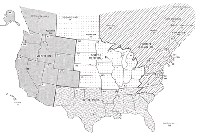
DATA COLLECTION AT GPS AND SPS SECTIONSThe GPS and SPS test sections are monitored at regular intervals to collect deflection, profile, and distress data. For purposes of data collection, the United States and the Canadian Provinces have been subdivided into four regions: (1) North Atlantic, (2) North Central, (3) Southern, and (4) Western. Each region is served by a Regional Support Contractor (RSC) who performs data collection at the test sections located within its region. The regional boundaries defining the jurisdiction of each RSC are shown in figure 1. One of the major data collection efforts in the LTPP program is the collection of longitudinal profile data at LTPP test sections. Longitudinal profile data are collected using an inertial profiler (except for test sections located in Alaska, Hawaii, and Puerto Rico, where data are collected using Dipstick®, a hand-operated device manufactured by the Face Company®. Figure 1. LTPP regions Profile data at LTPP test sections are collected along the two wheelpaths. The collected profile data are processed to compute roughness indices such as the International Roughness Index (IRI), Root Mean Square Vertical Acceleration (RMSVA), Slope Variance, and the Mays Index. The computed roughness parameters and the profile data are stored in the LTPP database after undergoing quality control checks. The data in the LTPP database are available to the research community. DEVICES FOR PROFILE DATA COLLECTIONEach RSC operates an inertial profiler to collect longitudinal profile data. From the inception of the LTPP program until the end of 1996, profile data at test sections were collected using a model DNC 690 incandescent profiler manufactured by K.J. Law Engineers. In late 1996, each RSC replaced their model DNC 690 profiler with a model T-6600 infrared profiler manufactured by K.J. Law Engineers. In September 2002, each RSC replaced their T-6600 profiler with an International Cybernetics Corporation (ICC) MDR 4086L3 laser profiler. At test sections located in Alaska, Hawaii, and Puerto Rico, longitudinal profile data collection is performed using Dipstick. RESEARCH OBJECTIVESAs described previously, data collection at LTPP test sections has been performed using three types of inertial profilers. Differences in the sampling interval, filtering procedures, and sensing devices for these profilers could lead to differences in profiles and smoothness index values among the devices. To ensure that high-quality and repeatable data are collected with each device, it is important to confirm the compatibility of the indices obtained using these devices. An analysis of LTPP profile data and equipment is necessary for quantifying the differences in IRI values among these profiling devices. The end result of this analysis will be an improvement in the quality of future LTPP data collection and an understanding of how to use the current LTPP profile data for analysis. Another useful result is quantification of the tolerances with which these profilers agree so that studies of roughness progression may be done with the knowledge of the differences among the devices. The main objective of this project is to quantify and resolve the differences in the longitudinal profile and roughness indices that are attributable to the different profiling equipment that have been used in the LTPP program. Under this research project, the following activities were carried out to meet the project objective:
All analyses were performed using the data that were collected during LTPP profiler comparison studies. ORGANIZATION OF THE REPORTChapter 2 presents a description of profiling devices that have been used in the LTPP program to collect longitudinal profile data. Chapter 3 presents an overview of LTPP profiler comparison studies that have been performed since the inception of the LTPP program. Chapter 4 presents a description of analytical procedures that were used in this research project to analyze profile data. Chapter 5 presents a description of the data collection characteristics of LTPP's profilers and a comparison of the devices. Chapter 6 presents the factors that can cause differences in IRI obtained from profilers and Dipstick. Chapter 7 presents several other findings from analysis of the profile data obtained from LTPP profiler comparison studies. Chapter 8 presents conclusions and recommendations for improvements to current procedures used in the collection and processing of profile data in the LTPP program.
|