U.S. Department of Transportation
Federal Highway Administration
1200 New Jersey Avenue, SE
Washington, DC 20590
202-366-4000
Federal Highway Administration Research and Technology
Coordinating, Developing, and Delivering Highway Transportation Innovations
 |
| This report is an archived publication and may contain dated technical, contact, and link information |
|
Publication Number: FHWA-HRT-05-054
Date: September 2005 |
|||||||||||||||||||||||||||||||||||||||||||||||||||||||||||||||||||||||||||||||||||||||||||||||||||||||||||||||||||||||||||||||||||||||||||||||||||||||||
Quantification of Smoothness Index Differences Related To Long-Term Pavement Performance Equipment TypeChapter 7: Other Findings From Analysis of The DataINTRODUCTIONThis chapter describes other findings that were observed during the analyses that were performed for this research project. The specific findings that are described in this chapter are:
IRI VALUES COMPUTED USING PROQUALThe IRI values in the LTPP database have been computed using ProQual. The data collected by the DNC 690 profiler were at 152.4-mm (6-inch) intervals, and the IRI was computed using the collected data. Data at 25-mm (1-inch) intervals were available for the T-6600 and ICC profilers. ProQual applies a 300-mm (11.8-inch) moving average onto this data, extracts the data at 150-mm (5.9-inch) intervals, then computes the IRI using this data. The IRI computation algorithm contained in ProQual is the algorithm that is described in World Bank Technical Report 46.(9) This report indicates that the IRI algorithm will apply a 250-mm (9.8-inch) moving average onto the profile data before computing the IRI when the data recording interval is less than 250 mm (9.8 inches). Subsequent literature on IRI have indicated that the moving average applied by the IRI algorithm should be omitted if a moving average has already been applied to the profile data.(2,30) The World Bank report did not specifically describe such a criterion. A study was conducted to compare the IRI values computed using ProQual with those computed using RoadRuf. In this study, RoadRuf was used for computing the IRI with and without the moving average being enabled in the IRI algorithm. The five profile runs collected by the North Atlantic ICC profiler at the test site used in the 2003 LTPP profiler comparison were used for this study. The profile data used for this study were the ProQual-processed data, which were at 150-mm (5.9-inch) intervals. The average IRI values computed from the five runs for each wheelpath at all five sites are presented in table 15. There was excellent agreement among IRI values computed using ProQual and RoadRuf when the moving average was applied by the IRI algorithm in RoadRuf. (Note: The IRI algorithm automatically applies the moving average.) However, the IRI values computed using RoadRuf with the moving average omitted were slightly higher than those computed using ProQual. The IRI for the individual wheelpaths considered in this study ranged from 0.92 to 2.81 m/km (58 to 178 inches/mi), and the percent difference between IRI from ProQual and IRI from RoadRuf with the moving average omitted in the IRI algorithm ranged from 0.7 to 2.3 percent. A researcher who obtains 150-mm (5.9-inch) interval profile data from the LTPP database and computes IRI values will obtain slightly higher values if the moving average is omitted in the IRI algorithm.
1 m/km = 5.28 ft/mi There is a slight difference in the IRI computed using the 25-mm (1-inch) data and that computed using ProQual. Table 16 shows the average IRI values (from five runs) computed using 25-mm (1-inch) data and ProQual along each wheelpath for the data collected by the North Atlantic ICC profiler at the test sites used in the 2003 LTPP profiler comparison. These are the same profile runs used for the previously described analysis. IRI for 25-mm (1-inch) data were computed using RoadRuf. The IRI for the 25-mm (1-inch) data were higher than the IRI computed using ProQual for all of the cases. The IRI for the individual wheelpaths considered in this study ranged from 0.92 to 2.81 m/km (58 to 178 inches/mi), and the percent difference in the IRI between RoadRuf and ProQual ranged from 2.1 to 5.0 percent. Thus, a researcher who obtains 25-mm (1-inch) interval profile data on LTPP sections and computes IRI values will obtain higher IRI values than those stored in the LTPP database for the corresponding data set. ACCELEROMETER EFFECTS ON THE K.J. LAW ENGINEERS T-6600 PROFILER DATADuring the 1996 regional verification test, each region performed a comparison of the DNC 690 and T-6600 profilers. The report on this comparison, prepared by the North Atlantic region, indicated that the profile data collected by the T-6600 profiler at rough sites were less repeatable than the data collected by the DNC 690 profiler.(25)
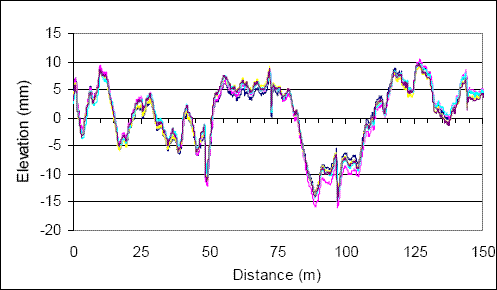
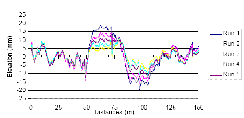
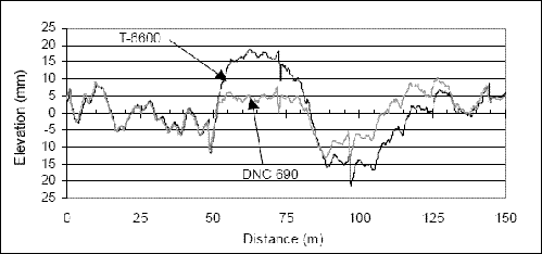
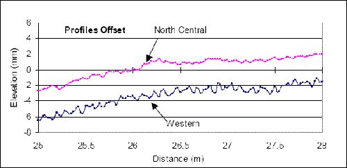
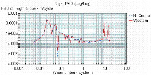
1 m/km = 5.28 ft/mi Figure 68 shows the overlaid repeat profile plots of the right-sensor profile data collected by the North Atlantic DNC 690 profiler at the rough concrete site (section 4) during the regional verification test. Profile data collected for five runs are shown in this figure. The data show excellent repeatability. 25.4 mm = 1 inch Figure 68. Overlaid right-sensor profiles of the K.J. Law Engineers DNC 690 profiler. Figure 69 shows the overlaid repeat profile plots of the right-sensor profile data collected by the T-6000 profiler at the same site. This figure also contains data collected for five profile runs. The profiles show good repeatability up to a distance of 50 m (164 ft); however, thereafter, the profiles show poor repeatability. 25.4 mm = 1 inch Figure 69. Overlaid right-sensor profiles of the K.J. Law Engineers T-6600 profiler. Figure 70 shows the right-sensor profile of one profile from the DNC 690 and T-6600 profilers. The two profiles agree very well with each other to a distance of about 50 m (164 ft); however, thereafter, they diverge from each other and converge again near the end of the section. An extremely rough feature is present on the pavement at 50 m (164 ft), and the poor repeatability of the data collected by the T-6600 profiler and the differences in the profiles for the DNC 690 andthe T-6600 profilers occur immediately after this feature. 25.4 mm = 1 inch Figure 70. Overlaid right-sensor profiles from the K.J. Law Engineers DNC 690 and T-6600 profilers. The cause of the poor repeatability in the profiles after this feature is that the accelerometer on the T-6600 profiler reached its upper limit when the rough feature was encountered. This fact was not known when the data from the 1996 verification test were analyzed. However, subsequent discussions with K.J. Law Engineers indicated that this indeed was the cause of the poor profile repeatability. Since the sensors on the DNC 690 profiler are housed on the vehicle body between the two axles, the accelerometers on the DNC 690 profiler are subjected to much less acceleration than that felt by the accelerometers on the T-6600 profiler, which are housed in the sensor bar located on the front of the vehicle. The IRI values for the five profiles shown in figure 68 for the DNC 690 profiler ranged from 1.82 to 1.90 m/km (115 to 120 inches/mi). The IRI values for the five profiles shown in figure 69 for the T-6600 profiler ranged from 1.87 to 1.91 m/km (119 to 121 inches/mi). The IRI for the two profiles shown in figure 70 were 1.85 m/km (117 inches/mi) for the DNC 690 profiler and 1.87 m/km (119 inches/mi) for the T-6600 profiler. Although there was poor repeatability of the profile data collected by the T-6600 profiler at this site, the IRI values for the five runs were similar. Also, the IRI values for the DNC 690 and T-6600 profilers were similar. Since IRI is primarily influenced by wavelengths between 1 and 30 m (3 and 100 ft), the previously described observations indicate that the poor repeatability of the profiles for the T-6600 profiler is caused by wavelengths greater than 30 m (100 ft). The North Atlantic profiler encountered a similar situation at another rough site that was used in the 1996 regional verification test. However, this situation was not encountered at any of the test sites that were used in the other three regions. It appears that when the T-6600 profiler encounters an extremely rough pavement feature, the accelerometer can go out of range, and this causes some contamination of the long-wavelength data that are collected after that event. However, this contamination appears to disappear after the profiler has traveled some distance after encountering the very rough spot. In 2000, all four of LTPP's profilers visited the K.J. Law Engineers facility in Michigan for computer maintenance and upgrades. The range of the accelerometers was increased during this maintenance by modifying the data collection software and by making modifications to the accelerometer cards in the computer. After this upgrade, the range of the accelerometers increased from ±2 gigabyte (GB) to ±8 GB, and the regional contractors indicated that they were able to obtain profiles that had better repeatability at rough sites. OBSERVATIONS ON SHORT-WAVELENGTH DATA COLLECTED BY THE K.J. LAW ENGINEERS T-6600 PROFILERSData from the 2000 Profiler ComparisonThe report prepared for the 2000 LTPP profiler comparison indicated that the profile data collected by the Western profiler at test sections 1 and 2, which were both AC pavements, were noisy; when compared to the data collected by the other three LTPP profilers.(14) Figure 71 shows an example of the data collected along the right wheelpath at section 2 by the Western and North Central profilers. The figure shows that a cyclic repetitive pattern is present in the Western profiler data, while this pattern does not occur in the data collected by the North Central profiler. Figure 72 shows PSD plots of profile data collected along the right wheelpath at section 2 by the North Central and Western profilers. Two dominant peaks occur in the PSD plot for the Western profiler data at wave numbers of approximately 9 and 15 cycles/m (2.7 and 4.6 cycles/ft), which correspond to a wavelength of 0.11 and 0.07 m (0.36 and 0.23 ft), respectively. These peaks were not observed in the data collected by the North Central profiler. 25.4 mm = 1 inch Figure 71. Right-sensor profile data collected by the Western and North Central profilers. 25.4 mm = 1 inch Figure 72. PSD plots of the right-sensor data collected by the North Central and Western profilers at site 2. The cause of the cyclic pattern seen in the profile data collected by the Western profiler is contamination occurring in the profile data at these two wave numbers. Examination of the right-wheelpath data collected at this site by the Western profiler using a PSD plot indicated that this phenomenon also was occurring along the right wheelpath. Evaluation of the data collected by the Western profiler at site 1 indicated that this phenomenon also was occurring along both wheelpaths. At sites 1 and 2, the two spikes in the left-sensor PSD plot occurred approximately at wave numbers of 5 and 14 cycles/m (1.5 and 4.3 cycles/ft), while for the right-sensor data, the spikes occurred approximately at wave numbers of 9 and 15 cycles/m (2.7 and 4.6 cycles/ft). For all repeat runs along a specific path, the spikes in the PSD plots occurred at the same wave numbers. An evaluation of the PSD plots of the profile data collected by the other three profilers at sites 1 and 2 showed similar spikes in the PSD plots for the following cases:
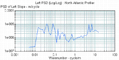
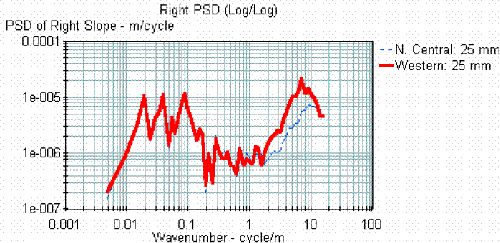
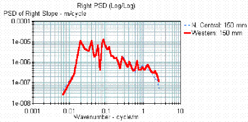
For the North Atlantic profiler, two spikes in the PSD plot were similar to those seen for the Western profiler. For the other two profilers, only a single spike was observed. For each profiler, the wave numbers at which these spikes appeared were the same for both sites, and the spikes also appeared at the same wave numbers for the repeat runs. However, there were slight differences in the wave numbers at which the spikes appeared between the profilers. The magnitude of the spikes observed in the PSD plots was highest for the Western profiler. This phenomenon of spikes in the PSD plots for wave numbers greater than 1 cycle/m (0.3 cycle/ft) was not detected in the data collected by all of the profilers at the other three sites used in the 2000 comparison. The effects of the contamination were apparent in the Western profiler at sites 1 and 2, since the profiles appeared to be noisy when compared to those obtained by the other three profilers. Although evidence of contamination was not apparent in the data collected by the other profilers, the PSD plots indicated that the data were affected for several cases as described previously. The cause of this contamination is not known. As this contamination was seen only at sites 1 and 2, it appears that an environmental condition during data collection, or some equipment factor, or a combination of both, caused the contamination of the profile data. When the 25-mm (1-inch) profile data are processed using ProQual, the short wavelengths will become attenuated. Thus, the PSD plots of the 150-mm (5.9-inch) averaged data will not show spikes. The contamination of the profile data occurs at very low wavelengths that are outside the wavelength range influencing the IRI. The IRI values computed for the Western profiler at sites 1 and 2 showed excellent agreement with the IRI values obtained for the other three profilers. Evaluation of Data from the 1998 LTPP Profiler ComparisonSpikes in PSD Plots for High Wave NumbersAn evaluation of the 25-mm (1-inch) data collected by the T-6600 profilers during the 1998 LTPP profiler comparison indicated that there was some contamination in the left-sensor profile data collected by the North Atlantic, North Central, and Western profilers. Figure 73 shows the PSD plot of the left-sensor profile data collected by the North Atlantic profiler during this comparison at site 1. 1 cycle/m = 0.3 cycle/ft Figure 73. PSD plot of the left-sensor profile data from the North Atlantic profiler. The PSD plot shows two distinct peaks for wave numbers of 5 and 7.1 cycles/m (1.52 and 2.16 cycles/ft), which correspond to wavelengths of 0.2 and 0.14 m (0.7 and 0.46 ft), respectively. These two spikes appear in the left-sensor profile data collected by the North Atlantic profiler at all four sites. The North Central profiler also exhibited similar spikes in the PSD plot for left-sensor data at wave numbers of 5 and 10 cycles/m (1.52 and 3.05 cycles/ft), which correspond to wavelengths of 0.2 and 0.1 m (0.7 and 0.3 ft), respectively. The PSD plots of the left-sensor data from the Western profiler at all of the sites had a single spike close to the wave number of 9 cycles/m (2.74 cycles/ft), which corresponds to a wavelength of 0.11 m (0.4 ft). The left-sensor data from the Southern profiler did not show such spikes in the PSD plots at any site. None of the profilers showed this phenomenon for data collected by the right sensor. The appearance of spikes in the PSD plot indicates that there is high spectral content at that specific wavelength in the profile data. Since these peaks were noted at all of the test sites, they obviously were not caused by a pavement feature. With the exception of the Southern profiler, some interference was being captured in the left-sensor data collected by the profilers at all of the test sections. The cause of this interference is unknown. These spikes appear at wavelengths that are outside the wavelength range influencing the IRI and, thus, no noticeable bias in IRI values computed using the 25-mm (1-inch) data was seen with the Southern profiler and the other three profilers. The RN is another index that is influenced by wavelengths between 0.5 and 11 m (1.6 and 36 ft). This index gives much more weighting to short wavelengths than the IRI. A comparison of left-wheelpath RN values for the Southern profiler and the other three profilers did not show a noticeable bias in RN values. Thus, it appears that the short-wavelength interferences observed in the left-sensor data collected by the North Atlantic, North Central, and Western profilers are also not influencing the RN. When profile data that have been processed using ProQual were examined using PSD plots, the spikes observed in the 25-mm (1-inch) data for the high wave numbers were not observed. This is because the application of the 300-mm (11.8-inch) moving average by ProQual attenuates short wavelengths. Contamination of Right-Sensor Signals in the Western ProfilerAn evaluation of the 25-mm (1-inch) interval profile data collected by the right sensor of the profilers indicated that the data collected by the Western profiler had some contamination at wavelengths of less than 1 m (3 ft). This phenomenon was seen in the right-sensor data collected by the Western profiler at all of the sites. The other three profilers showed good agreement for wavelengths in this range. Figure 74 shows PSD plots of the 25-mm (1-inch) right-sensor data from a test section for both the North Central and Western profilers. The PSD plots show that there is very good agreement 1 cycle/m = 0.3 cycle/ft Figure 74. PSD plots of 25-mm (1-inch) right-sensor data from the North Central and Western profilers. between the two profilers, except for the spectral content that has wave numbers greater than 1 cycle/m (0.3 cycle/ft), which corresponds to wavelengths of less than 1 m (3 ft). This phenomenon was observed for data collected by the Western profiler at all of the sites. Figure 75 shows the PSD plots for the ProQual-processed profile data for the two profile runs shown in figure 74. The application of the 300-mm (11.8-inch) moving average by ProQual attenuates profile features that have wave numbers greater than 1 cycle/m (0.3 cycle/ft), which correspond to wavelengths of less than 1 m (3 ft). Thus, the difference between the two profilers for wave numbers greater than 1 cycle/m (0.3 cycle/ft) that was seen in figure 74 is not noticeable in figure 75. The PSD plots for the two profilers shown in figure 75 agree fairly well for wave numbers greater than 1 cycle/m (0.3 cycle/ft). The plots show excellent agreement for wave numbers between 1 and 0.03 cycle/m (0.3 and 0.009 cycle/ft), which correspond to wavelengths between 1 and 30 m (3 and 100 ft). This is the wavelength range that is primarily influencing the IRI. Thus, there was good agreement in IRI between the two profiles. 1 cycle/m = 0.3 cycle/ft Figure 75. PSD plots of ProQual-processed right-sensor data from the North Central and Western profilers. The contamination of the right-sensor signal in the Western profiler occurs for short wavelengths that do not influence the IRI. Therefore, when an analysis of the IRI values from this comparison was performed, no bias in the IRI values for the Western profiler was seen. An evaluation of the RN values for the right-sensor data that were computed using the 25-mm (1-inch) interval profile data indicated that the RN values computed for the Western profiler were lower than the values obtained for the other three profilers at all four of the test sites. This indicates that the short-wavelength contamination that is present in the Western profiler data is affecting the RN. When overlaid left- and right-sensor data PSD plots of data collected by the Western profiler at the test sections were evaluated, the difference between the two sensors for wave numbers greater than 1 cycle/m (0.3 cycle/ft) was seen at all four of the test sites. An evaluation of the data collected by the Western profiler during the 1996 regional verification test and the data collected during the 2000 LTPP profiler comparison did not show such a trend. Therefore, it appears that this problem in the right sensor occurred at some point between 1996 and 1998, and was fixed at some point between 1998 and 2000. This also could have been an intermittent problem with the sensor that occurred when testing was performed for the 1998 profiler comparison. IRI DIFFERENCES FOR THE SOUTHERN PROFILER DURING THE 1991 PROFILER COMPARISONThe report prepared for the LTPP profiler comparison that was conducted in 1991 indicated that the data collected by the left sensor in the Southern profiler was giving IRI values that were much higher that those computed from data collected by the other three profilers.(11) The IRI values obtained for all four of the profilers for this comparison are presented in appendix A. The profile data collected by the Southern profiler at the eight test sections used in this comparison were compared to the data collected by the Western profiler to identify the cause of the high IRI values. An evaluation of the PSD plots of the Southern profiler data did not indicate any evidence of contamination at a specific wavelength. However, the PSD plots indicated that over a wavelength range of between 1 and 10 m (3 and 33 ft), the left-sensor data collected by the Southern profiler had slightly more spectral content than the data collected by the Western profiler. The cause of this phenomenon is unknown. This phenomenon resulted in higher IRI values being computed for the data collected by the left sensor in the Southern profiler. A comparison of the profile data collected by the two profilers using filtering techniques did not show the cause of the high IRI values of the left-sensor data from the Southern profiler. The data collected by the Southern profiler during the 1992 comparison did not show this phenomenon. SUMMARY OF THE FINDINGSProQual applies a 300-mm (11.8-inch) moving average onto the 25-mm (1-inch) profile data collected by the T-6600 and ICC profilers and extracts the data points at 150-mm (5.9-inch) intervals. The IRI values are computed using this averaged data. ProQual does not apply a moving average before computing the IRI for the data collected by the DNC 690 profiler, which are at 152.4-mm (6-inch) intervals, with a moving average having already been applied to this data by the profiler. ProQual uses the IRI algorithm documented in the World Bank report.(9) The IRI algorithm applies a 250-mm (9.8-inch) moving average onto the profile data before computing IRI if the data recording interval is less than 250 mm (9.8 inches). Literature published after this report have indicated that the moving average applied by the IRI algorithm should be omitted if the profile data have already been subjected to a moving average.(2,30) However, the IRI values that are currently in the LTPP database have been computed by subjecting the profile data to two moving averages, one applied by ProQual and the other applied by the IRI algorithm. If a researcher obtains profile data from the LTPP database and specifically omits the moving average that is applied by the IRI algorithm, the computed IRI values will be slightly higher than the IRI values for the corresponding section in the LTPP database. If a researcher obtains 25-mm (1-inch) interval LTPP profile data and computes the IRI, the resulting IRI values will be slightly higher than the corresponding IRI values that are in the LTPP database. This is because the IRI in the LTPP database have been computed after the 25 mm (1-inch) profile data have been processed using ProQual, which applies a 300-mm (11.8 inch) moving average onto the 25-mm (1-inch) data, extracts data at 150-mm (5.9 inch) intervals, and then uses that data to compute IRI. The profile data for the repeat runs conducted by the T-6600 profiler before June 2000 may show poor repeatability at sections where an extremely rough localized feature is present on the pavement. This is because an extremely rough localized feature can cause the accelerometer(s) in the profiler to exceed the accelerometer range and contaminate the long wavelengths after that event. This occurrence will not affect the IRI computed from the profiles, since the contaminated wavelengths are outside of the wavelength range influencing the IRI. The range of the accelerometers in LTPP's T-6600 profilers was increased during May;June 2000, and the data collected after that were not expected to show such behavior. In some instances, PSD plots of data collected by T-6600 profilers showed either one or two spikes for wave numbers greater than 5 cycles/m (1.52 cycles/ft), which corresponds to wavelengths of less than 0.2 m (0.7 ft). This is an indication that there is some contamination in the profile data in the short wavelengths. This phenomenon will not be seen in the profile data that is in the LTPP database, since wavelengths of less than 1 m (3 ft) have been attenuated in these profiles by the application of the moving average by ProQual. The cause of this contamination is not known. This contamination affects neither the IRI or the RN, since it occurs at wavelengths outside of the wavelength range influencing these two smoothness indices. Currently in the LTPP program, quality control of the profile data is performed using the ProQual-processed data. To detect contamination such as this, quality control procedures must be performed on the 25-mm (1-inch) data. An analysis of the data collected for the 1998 LTPP profiler comparison indicated that some contamination was present in the data collected by the right sensor of the Western profiler at wave numbers greater than 1 cycle/m (0.3 cycle/ft), which corresponded to wavelengths less than 1 m (3 ft). This phenomenon will not be seen in the ProQual-processed data, since short wavelengths are attenuated by the application of the moving average. The contamination does not affect the IRI because it occurs at wavelengths that are outside of the range of the wavelengths influencing the IRI. However, it is affecting the RN computed from the 25-mm (1-inch) data. This phenomenon was not noted in the data collected by the Western profiler during the 1996 verification study nor in the data collected during the 2000 profiler comparison. Therefore, it appears that this phenomenon occurred sometime between 1996 and 1998, and was fixed sometime between 1998 and 2000, or perhaps this is an intermittent problem. Currently, in the LTPP program, quality control of the profile data is performed using the ProQual-processed data. To detect contamination such as this, quality control procedures must be performed on the 25-mm (1-inch) data.
|
|||||||||||||||||||||||||||||||||||||||||||||||||||||||||||||||||||||||||||||||||||||||||||||||||||||||||||||||||||||||||||||||||||||||||||||||||||||||||