U.S. Department of Transportation
Federal Highway Administration
1200 New Jersey Avenue, SE
Washington, DC 20590
202-366-4000
Federal Highway Administration Research and Technology
Coordinating, Developing, and Delivering Highway Transportation Innovations
 |
| This report is an archived publication and may contain dated technical, contact, and link information |
|
Publication Number: FHWA-HRT-06-111 Date: August 2006 |
PDF files can be viewed with the Acrobat® Reader®
The Long Term Pavement Performance (LTPP) program is a 20-year study of in-service pavements across North America. Its goal is to extend the life of highway pavements through various designs of new and rehabilitated pavement structures, using different materials and under different loads, environments, subgrade soil, and maintenance practices. LTPP was established under the Strategic Highway Research Program and is now managed by the Federal Highway Administration.
FHWA Contact: Larry Wiser, HRDI-13, 202–493–3079, larry.wiser@fhwa.dot.gov
Traffic loads are an essential input to the pavement analysis and design process. In the past, the impact of traffic was aggregated into equivalent single-axle loads and input into regression-based pavement performance equations. The recently developed Mechanistic-Empirical Pavement Design Guide (M-E PDG) (NCHRP 1-37A) characterizes traffic in terms of axle numbers by type and load frequency distribution, including axle load spectra. This is a significant improvement over past methods because it allows for a mechanistic pavement design approach.
Traffic data collection is carried out using several data acquisition technologies, including weigh in motion (WIM) systems, automated vehicle classifiers (AVC), and automated traffic recorders (ATR). The data coverage of traffic data acquisition systems can vary widely from operating continuously to providing simple 48-hour data coverage. Hence, there is wide variation in the characteristics of traffic data used for designing pavements.
The challenge for both pavement design and traffic engineers is to determine the combination of traffic data acquisition technology and the amount of time coverage required for particular pavement design situations outlined in the M-E PDG. The problem needs to be addressed in light of the sensitivity of pavement design and performance to the level of traffic data input. Understanding this sensitivity will allow for the optimization of traffic data collection resources allocated for pavement design processes.
The Long-Term Pavement Performance (LTPP) program conducted a study to establish the relationship between the traffic data collection effort, including the combination of traffic data acquisition technologies and length of time coverage, and the variability in predicted pavement life using the M-E PDG.
For the study, researchers used extended-coverage WIM data from the LTPP Standard Data Release (SDR) 16.0 to simulate a wide range of traffic data collection scenarios. This resulted in the development of two specific products:
To conduct the study, researchers established data collection scenarios by expanding the four traffic input levels of the M-E PDG, taking into consideration equipment technology and the length of the site-specific coverage. Table 1 provides a summary of the scenarios.
SS: Site-specific, R: Regional, N: National (M-E PDG defaults)
The researchers also used SDR 16.0 to identify LTPP sites with WIM data coverage exceeding 299 days per year. A total of 178 sites satisfied this criterion for multiple years. After identifying the sites, the researchers extracted daily traffic data summaries for these sites from the Central Traffic Database of SDR 16.0.
The researchers then selected 30 sites (15 with flexible and 15 with rigid pavements) to represent a wide range of layer thicknesses and average annual daily truck traffic volumes for detailed simulation in the M-E PDG.
Following this step, the researchers obtained site-specific traffic simulations from the extended-coverage WIM data using procedures in the 2001 Traffic Monitoring Guide (FHWAPL-01-021). To estimate regional averages, the researchers used clustering techniques to group test sections with similar traffic characteristics.
The researchers then conducted a sensitivity analysis to evaluate the variation in predicted pavement life using the various traffic data collection scenarios. Ranges in pavement life errors as a function of confidence interval for each scenario also were developed, using both mean and low-percentile traffic input (figures 1 and 2, respectively).
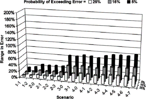
Figure 1. Range in M-E PDG pavement life prediction errors from mean traffic input.
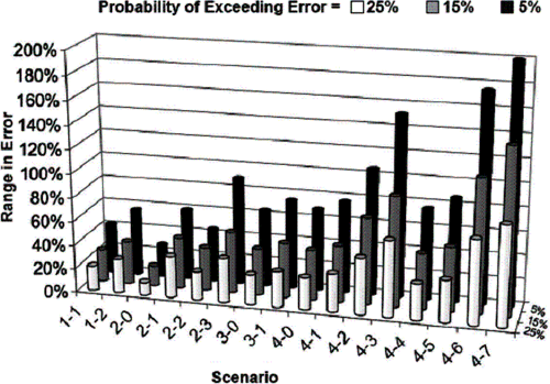
Figure 2. Range in M-E PDG pavement life prediction errors from low-percentile traffic input.
From a pavement design point of view, traffic underestimation is considered the most critical problem because it leads to the overestimation of pavement life and can produce pavement structures with insufficient structural capacity. As a result, the researchers considered the lower end of the percentile range computed for each traffic input element to be the most significant in the study. This enabled researchers to compute the range in mean error resulting from specifying the lowest percentile for all of the traffic inputs simultaneously.
While very conservative, this method addresses reliability by providing the magnitude of error that will not be exceeded for an input scenario at a given confidence level.
In addition to establishing approximate ranges for pavement life prediction errors for various collection scenarios, the researchers drew the following conclusions from the analysis:
Pavement design and traffic engineers can use the results from this study to establish traffic data collection scenarios considering a maximum acceptable pavement life prediction error under a selected confidence level. The data from this and subsequent analyses also could be used to implement traffic data collection procedures for given design situations.
In addition, pavement designers can use these findings to better understand the effect specific traffic data sources may have on predicted pavement life from the M-E PDG. Professionals also could use the final report to guide agencies in developing an implementation plan for the anticipated American Association of State Highway and Transportation Officials‘ pavement design guide, in terms of future traffic data collection procedures and use.
Researcher–This study was performed by Nichols Consulting Engineers, Chtd. and Washington State University, Contract No. DTFH61-02-D-00136.
Distribution–This TechBrief is being distributed according to a standard distribution. Direct distribution is being made to the Divisions and Resource Center.
Availability–The publication from which this TechBrief was developed, Optimization of Traffic Data Collection for Specific Pavement Applications (FHWA-HRT-05-079), is available from the National Technical Information Service, 5285 Port Royal Road, Springfield, VA 22161. A limited number of copies will be available from the Research and Technology Product Distribution Center, HRTS-03, FHWA, 9701 Philadelphia Court, Unit Q, Lanham, MD 20706, telephone: 301–577–0818, fax: 301–577–1421.
Key Words–LTPP traffic data, traffic data collection, NCHRP 1-37A, M-E Pavement Design Guide, axle load spectra, sensitivity analysis.
Notice–This document is disseminated under the sponsorship of the U.S. Department of Transportation in the interest of information exchange. The U.S. Government assumes no liability for the use of the information contained in this document. The U.S. Government does not endorse products or manufacturers. Trademarks or manufacturers’ names appear in this report only because they are considered essential to the objective of the document.
Quality Assurance Statement–The Federal Highway Administration (FHWA) provides high-quality information to serve Government, industry, and the public in a manner that promotes public understanding. Standards and policies are used to ensure and maximize the quality, objectivity, utility, and integrity of its information. FHWA periodically reviews quality issues and adjusts its programs and processes to ensure continuous quality improvement.

