U.S. Department of Transportation
Federal Highway Administration
1200 New Jersey Avenue, SE
Washington, DC 20590
202-366-4000
Federal Highway Administration Research and Technology
Coordinating, Developing, and Delivering Highway Transportation Innovations
 |
| This report is an archived publication and may contain dated technical, contact, and link information |
|
Publication Number: FHWA-HRT-06-121 Date: November 2006 |
In the initial work on this project, the data analysis team specifically developed SMP site data as called for in the task order. The task order clearly identified SMP sites to be the basis of this project. Task 3 had the following requirement:
Make a comparison of performance data from the LTPP Seasonal Monitoring Program (SMP) sites that are located in the southern reaches of the wet-freeze zone or the northern reaches of the wet no-freeze zone versus those sites that are further north in the wet-freeze zone.The task order also stated:
Initial trend analysis studies should determine whether the SMP data support the contention that the rate of accumulation of pavement distress is greater (more rapid) in climatic zones where there are a large number of annual freeze-thaw cycles versus deep frost penetration.It is assumed that the intent of using SMP data for this study was to make use of frost depth measurements taken at the sites, which were based on resistivity, temperature, and moisture data. SMP sites are the only source of actual frost penetration measurements in the LTPP database.
Tables 2, 3, and 4 list all SMP sites in the wet freeze, wet no-freeze, and dry freeze zones, respectively. Included in the tables are the experiment designations of each section, which are based on the type of pavement structure as defined in the Long Term Pavement Performance Information Management System Pavement Performance Database User Guide.(3) Table 5 summarizes the number of SMP test sections in each climatic zone separated by experiment type.
The number of test sites listed in table 5 includes all SMP sites. The actual number of potential sites for use in this study is more limited when considering only the following factor:
…sites that are located in the southern reaches of the wet-freeze zone or the northern reaches of the wet no-freeze zone versus those sites that are farther north in the wet freeze zone.There are GPS-1 sites in the wet no-freeze zone that could potentially be included in the "northern reaches of the wet no-freeze zone." Combining these sites with the nine GPS-1 sites in the wet freeze zone provides a total of 13 test sections in the wet freeze zone to analyze. Six of the SPS sites could also be used; however, these SPS projects were constructed relatively recently and many have not yet developed a clear damage trend.
| State | State Code | SHRP ID | Experiment |
|---|---|---|---|
| CT | 09 | 1803 | GPS-1 |
| IN | 18 | 3002 | GPS-3 |
| KS | 20 | 4054 | GPS-4 |
| ME | 23 | 1026 | GPS-1 (and GPS-6B) |
| MD | 24 | 1634 | GPS-2 |
| MA | 25 | 1002 | GPS-1 |
| MN | 27 | 1018 | GPS-1 |
| MN | 27 | 1028 | GPS-1 |
| MN | 27 | 4040 | GPS-4 |
| MN | 27 | 6251 | GPS-1 |
| NE | 31 | 3018 | GPS-3 |
| NH | 33 | 1001 | GPS-1 |
| NY | 36 | 4018 | GPS-4 |
| OK | 40 | 4165 | GPS-2 |
| PA | 42 | 1606 | GPS-4 |
| VT | 50 | 1002 | GPS-1 |
| MB | 83 | 3802 | GPS-3 |
| ON | 87 | 1622 | GPS-1 |
| PQ | 89 | 3015 | GPS-3 |
| DE | 10 | 0102 | SPS-1 |
| NE | 31 | 0114 | SPS-1 |
| NY | 36 | 0801 | SPS-8 (AC) |
| OH | 39 | 0204 | SPS-2 |
| Note: | GPS-1 | AC over granular base |
|---|---|---|
| GPS-2 | AC over bound base | |
| GPS-3 | JPCP | |
| GPS-4 | JRCP | |
| GPS-6 | AC overlay over existing AC | |
| SPS-1 | AC | |
| SPS-2 | PCC | |
| SPS-8 | Environmental (AC and PCC) |
| State | State Code | SHRP ID | Experiment |
|---|---|---|---|
| GA | 13 | 1005 | GPS-1 |
| GA | 13 | 1031 | GPS-1 |
| GA | 13 | 3019 | GPS-3 |
| MS | 28 | 1016 | GPS-2 |
| MS | 28 | 1802 | GPS-2 |
| NC | 37 | 1028 | GPS-1 |
| TX | 48 | 1060 | GPS-1 |
| TX | 48 | 1068 | GPS-1 |
| TX | 48 | 1077 | GPS-1 |
| TX | 48 | 1122 | GPS-1 |
| TX | 48 | 3739 | GPS-1 |
| TX | 48 | 4142 | GPS-4 |
| TX | 48 | 4143 | GPS-4 |
| WA | 53 | 3813 | GPS-3 |
| AL | 01 | 0101 | SPS-1 |
| AL | 01 | 0102 | SPS-1 |
| NC | 37 | 0201 | SPS-2 |
| NC | 37 | 0205 | SPS-2 |
| NC | 37 | 0208 | SPS-2 |
| NC | 37 | 0212 | SPS-2 |
| VA | 51 | 0113 | SPS-1 |
| VA | 51 | 0114 | SPS-1 |
| State | State Code | SHRP ID | Experiment |
|---|---|---|---|
| CO | 08 | 1053 | GPS-1 |
| ID | 16 | 1010 | GPS-1 |
| ID | 16 | 3023 | GPS-3 |
| MT | 30 | 8129 | GPS-1 |
| SD | 46 | 9187 | GPS-1 |
| UT | 49 | 1001 | GPS-1 |
| UT | 49 | 3011 | GPS-3 |
| WY | 56 | 1007 | GPS-1 |
| MB | 83 | 1801 | GPS-1 |
| SK | 90 | 6045 | GPS-1 (and GPS-6B) |
| MT | 30 | 0114 | SPS-1 |
| NV | 32 | 0101 | SPS-1 |
| NV | 32 | 0204 | SPS-2 |
| SD | 46 | 0804 | SPS-8 (AC) |
| Experiment | Wet Freeze | Wet No-Freeze | Dry Freeze | Total |
|---|---|---|---|---|
| GPS-1 | 9 | 9 | 8 | 25 |
| GPS-2 | 2 | 2 | 0 | 4 |
| GPS-3 | 4 | 2 | 2 | 8 |
| GPS-4 | 3 | 2 | 0 | 5 |
| GPS-6 | 1 | 0 | 1 | 2 |
| SPS-1 | 2 | 4 | 2 | 8 |
| SPS-2 | 1 | 4 | 1 | 6 |
| SPS-8 | 1 | 0 | 1 | 2 |
The number of test sections must be compared with the number of variables that can contribute to pavement performance. Task 3 calls for the consultant to conduct a trend analysis in which the rates of distress accumulation will be analyzed considering the following factors:
In addition, task 5 asks the contractor to quantify the effect on pavement performance based on the analysis of the following factors:
From these lists, a total of nine variables were incorporated into the dataset:
Nineteen potential AC pavements and eleven potential PCC pavements do not compare well against the nine potential variables. For a reasonable statistical analysis, there should be a larger number of sites for each independent variable. Assuming a desired minimum of 10 to 20 sites for each independent variable, 90 to 180 sites would be desirable to meet the needs of this project.
In addition, evaluation was performed to determine the actual number of SMP sites that were available with reasonable performance data. For the AC pavement sites, 9 sites of the 19 noted above had reasonably deterioration trends. At most, 15 sites could be included in the analysis equating to 8 sites in the deep-freeze environment, 4 sites in the moderate-freeze environment, and 3 sites in the no-freeze environment. With this breakdown, there are more independent variables than sites in either environment. This further illustrated the necessity to use additional LTPP test sections.
The important question facing the analysis team was: "Could the objectives be met by expanding beyond the SMP sites?" As will be explained in the following paragraphs, the answer was a resounding "Yes."
Table 6 lists only the 23 reported SMP sites with measured, nonzero, frost depths. The actual measured frost depths vary from one measurement to four. The two frost depths reported in this table are the largest (representing the coldest year) and smallest (representing the warmest year) annual maximum frost depth over the monitoring period, which was—at most—4 years. One of the challenges when dealing with annual frost depths is that the actual frost depth can vary markedly from year to year. Simply stated, the frost depth is as changeable as the weather, and the severity of the winter weather can change drastically from one year to the next. As can be seen in table 6, frost depths vary between 25 percent and 50 percent from year to year. In the event that only one measurement was taken, the same value was reported in the table for both the maximum and minimum year. Where the minimum measured value is shown as zero, then two or more measurements were taken with 1 year receiving no frost penetration. The most noticeable variation in frost measurements is section 364018, which indicates 2.09 m (6.86 ft) of frost 1 year and no frost another year.
In actuality, using a limited number of frost measurements is not a good design practice because of its variability. The maximum frost depth measured during one of the more severe winters is often used for design values. For example, the Washington State Department of Transportation (WSDOT) has used frost measurements taken in 1950, which was a very severe winter, as its basis for the part of the pavement design that accounts for frost.(4)
| State Code | SHRP ID | Pavement Type | Average FI Degree-Celsius days | Average FTC | Maximum Frost Depth m (ft) | Minimum Frost Depth m (ft) |
|---|---|---|---|---|---|---|
| 42 | 1606 | JRCP | 353.8 | 91.3 | 0.415 (1.4) | 0 (0) |
| 31 | 0114 | AC | 409.8 | 105.1 | 0.865 (2.8) | 0.665 (2.2) |
| 36 | 0801 | AC | 436.9 | 86.6 | 0.835 (2.7) | 0 (0) |
| 25 | 1002 | AC | 437.8 | 117.9 | 0.76 (2.5) | 0 (0) |
| 31 | 3018 | JPCP | 478.8 | 117.8 | 1.22 (4.0) | 0 (0) |
| 56 | 1007 | AC | 545.8 | 140.4 | 0.945 (3.1) | 0.515 (1.7) |
| 30 | 8129 | AC | 579.7 | 151.8 | 1.025 (3.4) | 0.82 (2.7) |
| 36 | 4018 | JRCP | 583.6 | 113.0 | 2.095 (6.9) | 0 (0) |
| 16 | 1010 | AC | 665.2 | 135.9 | 0.76 (2.5) | 0.61 (2.0) |
| 30 | 0114 | AC | 687.8 | 113.7 | 1.004 (3.3) | 1.004 (3.3) |
| 46 | 9187 | AC | 757.1 | 117.0 | 1.465 (4.8) | 1.115 (3.7) |
| 50 | 1002 | AC | 786.0 | 98.2 | 0.79 (2.6) | 0.63 (2.1) |
| 23 | 1026 | AC | 827.6 | 115.1 | 1.77 (5.8) | 1.00 (3.3) |
| 46 | 0804 | AC | 977.9 | 107.2 | 1.435 (4.7) | 0.875 (2.9) |
| 87 | 1622 | AC | 1080.8 | 102.5 | 1.23 (4.0) | 1.03 (3.4) |
| 27 | 1018 | AC | 1108.3 | 92.9 | 2.13 (7.0) | 1.865 (6.1) |
| 89 | 3015 | JPCP | 1227.6 | 84.4 | 1.38 (4.5) | 0.97 (3.2) |
| 27 | 4040 | JRCP | 1347.8 | 90.7 | 2.21 (7.3) | 2.01 (6.6) |
| 27 | 1028 | AC | 1387.7 | 87.0 | 2.38 (7.8) | 2.38 (7.8) |
| 27 | 6251 | AC | 1484.9 | 88.5 | 2.25 (7.4) | 1.895 (6.2) |
| 83 | 1801 | AC | 1732.9 | 88.9 | 1.975 (6.5) | 1.16 (3.8) |
| 83 | 3802 | JPCP | 1862.8 | 79.9 | 2.31 (7.6) | 1.71 (5.6) |
| 90 | 6405 | AC | 1863.3 | 83.3 | 2.05 (6.7) | 2 (6.3) |
There has been a considerable amount of work relating frost depth to FI. A detailed description in estimating frost depths based on soil properties and FI is covered in some detail in the WSDOT Pavement Guide for Design, Evaluation and Rehabilitation, Volume 2, Pavement Notes.(4) In Minnesota, it was found that using a similar approach with modification in the standard nfactors, thermal conductivity, and mean annual soil temperature, the majority of the calculated depths fell within ±13.3 percent of the depths measured.(5)
There is clearly a relationship between FI and frost depth. As shown in figure 1, graphing the measured frost depth for the SMP sites and the FI for the same sites shows a reasonable trend between measured frost depth and the average FI from the virtual weather station for each site. The trend line developed by using a linear least squares regression approach indicates that the frost depth equals 0.0014 times the average FI.
Figure 1. Graph. Plot of measured maximum frost depth to FI.
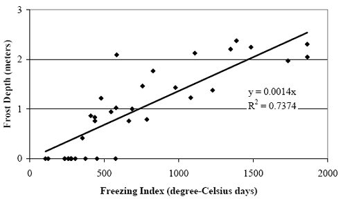
The regression data indicated that this trend line fits the data with an R-squared (coefficient of determination) of 0.74, which is quite good using such widespread national data. In the context of this study, this correlation is acceptable because the FI would be used only to compare the frost conditions at each site. The approximate frost condition will provide enough information to account for frost exposure in the pavement performance models.
Considering the variability in measured frost depths over only a few years, it could be argued that estimating the average frost depth based on almost 20 years of FI measurements would relate better to 15 to 25 years of pavement performance than four or fewer isolated frost measurements.
For these reasons, the analysis team proposed to expand the study to include non-SMP, GPS, and SPS sites using the FI as an indicator of actual frost depth. This approach was included in the work plan for phase 2 of the study, which was approved by the PFS Technical Advisory Committee and the FHWA LTPP Data Analysis contracting officer’s technical representative (COTR).Therefore, the analysis team expanded the dataset to include LTPP experiments listed in table 7. Complete details on each experiment can be found in the Long Term Pavement Performance Information Management System Pavement Performance Database User Guide.(3)
| Pavement Type | LTPP Experiment | Description |
|---|---|---|
| Flexible | GPS-1 | Asphalt concrete pavement (ACP) on granular base |
| Flexible | GPS-2 | ACP pavement on bound base |
| Flexible | GPS-6 | ACP overlay of existing ACP |
| Flexible | SPS-1 | Strategic study of structural factors for ACP |
| Flexible | SPS-8 | Study of environmental effects in the absence of heavy loads |
| Rigid | GPS-3 | Jointed plain concrete pavement (JPCP) |
| Rigid | SPS-2 | Strategic study of structural factors for rigid pavements |
| Rigid | SPS-8 | Study of environmental effects in the absence of heavy loads |
All databases developed for use in this study were created in Microsoft Access 2000© format to be consistent with the format of the LTPP Information Management System (IMS) Data Release 17.0 (version 2004.01). Some of the necessary tables were imported from the data release without requiring modification; other tables were created or imported from the data release and modified to aid in the data extraction process. Queries were then developed to acquire the desired data in the proper format as well as to perform calculations.
The task order proposal request for this project outlined the following factors to be considered in the analysis:
To evaluate the effect of frost penetration and FTCs on pavement performance, other contributing factors, listed above, had to be taken into consideration. There are two methods that can be used to address this. The first is to separate the dataset into groups of similar test sections (i.e., structural properties) under similar conditions in terms of climate, materials, and traffic. In turn, regression analysis would be performed on each of the groupings. Considering the number of variables that need to be accounted for, the data would be separated into a large number of groups to explain all of the combinations of interest. The primary disadvantage to this method is that the results can be confounded by the grouping method used. In addition, each regression is based on a smaller subset of the entire dataset making the models less robust.
The other alternative is to perform regression analysis on the entire dataset and include all of the factors as explanatory variables within the model. This allows the contribution of each factor to be explained independently in the model. Comparisons of predicted performance can be made by keeping all inputs constant except for the factors of interest for the study (i.e., climatic variables). This approach was adopted for modeling performance in this study; therefore, each of the factors listed previously was incorporated into the datasets and used as explanatory variables in the models. The following paragraphs contain descriptions of each explanatory variable as well as the performance measures selected for evaluation.
Separate datasets were developed for each pavement type. To account for the performance of flexible pavements, test sections classified as SPS-1, SPS-8, GPS-1, GPS-2, and GPS-6 experiments were included in the study. Only test sections constructed with jointed plain concrete pavement were considered for use in the rigid pavement dataset (SPS-2, SPS-8, and GPS-3 experiments). These experiments provide test sections that have various structures and are exposed to a wide array of climatic and traffic conditions.
It should be noted than some test sections received rehabilitation during LTPP monitoring. This resulted in test sections changing experiment designation; therefore, one test section may be included in two experiments. Data collected both before and after the rehabilitation were included in the dataset (with different experiment designations).
The experiment classification was included as an explanatory variable (labeled as EXP) in the models to account for possible differences in performance between the experiment types. For example, GPS-6 test sections have been overlaid while the other flexible experiments have not.
Precipitation, CI, FTCs, longitude, latitude, and elevation were included in the datasets to account for climatic effects. As discussed in previous sections, the FI was used to provide a relative comparison of frost depth conditions at each location.
Annual FI and annual number of FTCs were obtained directly from the virtual weather station table (CLM_VWS_TEMP_ANNUAL). Operating weather stations are not available at every test section; therefore, virtual weather stations were created by extrapolating climatic data from up to five nearby weather stations. This gives an estimation of the actual weather conditions at the location of the test section. To obtain values that are representative over the performance life of the pavement section, annual averages were computed for all years available, which is at least 20 years of data.
Annual cooling index (CI) was not directly available from the LTPP data release, and it was computed for each year with temperature values in the CLM_VWS_TEMP_ANNUAL table. Like FI and FTC, the values used in the analysis dataset were annual averages from at least 20 years of data. The equation to calculate CI is shown in equation 1.
| (1) |
where
Annual precipitation data (PRECIP) also was obtained from virtual weather station data in the CLM_VWS_PRECIP_ANNUAL table. The data used in the analysis dataset were the annual average of values in the table for each section, which consist of least 20 years of data.
Collectively, these four factors describe the relevant climatic conditions for this study. FI has been closely correlated to depth of frost penetration. Because actual frost depth measurements were not taken at the test sections, FI was used as a surrogate to frost depth. FI and FTC are the primary factors investigated in the analysis, and they describe the cold portion of the climatic spectrum. On the other hand, CI offers information regarding the warmer portion of the climate. Two sites with approximately the same winter weather conditions (similar FI values) could have drastically different summer conditions, which are indicated by CI. For example, test sections 361001 (located in New York) and 851801 (located in Newfoundland) both exhibit similar winter conditions. The FI for both sections is 505 degree-Celsius days, and the FTC is 90 and 100 for test sections 361001 and 851801, respectively. However, there is a large difference in CI. Newfoundland experiences a much milder summer with a CI of 25 d gree-Celsius days, while the summer in New York is considerably warmer, exhibiting a CI of approximately 300 degree-Celsius days. This difference in summer conditions could contribute to varian performance and must be considered when comparing performance trends.
Geographic parameters of longitude, latitude, and elevation were incorporated in the dataset, but their contribution to pavement performance was found to be insignificant. These data were queried from the INV_ID or SPS_ID tables, depending on the experiment.
In addition to strain values discussed previously, accumulated surface distress, change in roughness with age, absolute roughness, rut depth (flexible pavements), and faulting (rigid pavements) were all used as performance measures.
Pavement performance is a function of pavement age. As such, pavement age was calculated and coupled with the performance measures in the dataset. Depending on the experiment type, either the date of original construction or date of rehabilitation was extracted from the LTPP database. Details on the extracted data can be found in table 8. Data collection dates were subtracted from the established construction/rehabilitation dates to establish pavement age. A new construction/rehabilitation date was generated for each new rehabilitation activity. Subsequent data collection dates were subtracted from the new reference age. Performance could then be predicted as a function of pavement age.
| LTPP Experiment | LTPP Database Table |
|---|---|
| GPS-1, -2, and -3 | INV_ID |
| SPS-1, -2, and -8 | SPS_ID |
| GPS-6 | INV_MAJOR_IMP or RHB_IMP |
Only distress data collected using manual techniques were used in this study. Data collected using photographic/automated techniques were not included. Research that has been conducted by Rada et al.(6) evaluating the variability of LTPP distress data collection found that the overall variability of distress collected manually is lower than that collected by photographic methods. In addition, the apparent bias of data collected by photographic techniques was much higher than that collected manually. The study found a reasonable correlation between the two methods; however, manual data collection tended to yield higher amounts of distress than the photographic techniques. Considering these findings, only manual data collection was included in the study to eliminate variability introduced when data from multiple techniques are used. The study also concluded that total distress quantities exhibit less bias and variability than each severity level independently. The recorded amounts of distress at each severity level were summed. Different methods were used to combine severity levels for each dataset, each of which is explained subsequently.
The LTPP pavement distress identification procedures characterize the various distress categories in terms of the type of the distress, the severity of the distress (i.e., low, moderate, and high severity), and the amount of the distress (area, length, number of occurrences).
There are two primary alternatives available to represent measured distress accumulation with pavement age for performance modeling. The first option would be to represent the accumulation of distress over time for the three levels of severity separately. This would add a very high level of complexity to the process and segment an already limited amount of distress measurements. Studies have shown that there is greater variability in classification of severity level for a distress type than that associated with distress type identification.(6) Modeling each severity level independently would compound this variability. To counter this, the quantities of all three severity levels could be summed (without weighting factors) for each distress type, which would reduce the variation apparent between severity levels. For example, a survey consisting of 3 m2 of low severity, 5 m2 of moderate severity, and 2 m2 of high severity fatigue would be treated as 10 m2 of fatigue for regression development. The disadvantage of this approach is that it eliminates the resolution gained by collecting pavement distress measurements in terms of severity levels.
Pavement distress measurements have historically been collected in terms of low, moderate, and high severity levels,(7) which where developed for implementation into pavement management systems. The pavement distress measurements were initially compiled as a composite index where the measurements of several distress types and severity levels were combined into a single index(8) such as the Pavement Condition Index (PCI) used in the Micro PAVER™ PMS system. More recently, the distress measurements have been compiled as a unique pavement distress index where the severity levels of a single distress type are combined to produce a specific distress index.(9) The distress index is usually expressed as 100 minus the sum of the deduct points, where separate deduct points are computed for the amount of distress in each severity level for a specific distress type.
It is important to that that most SHAs use different pavement distress indices based to some extent on the specific pavement management system they have adopted, and a wide range of systems are in use throughout the United States. One of the predominant pavement condition deduct systems for unique pavement distress indices was used in this study to represent the change in flexible pavement distress with time.(10)
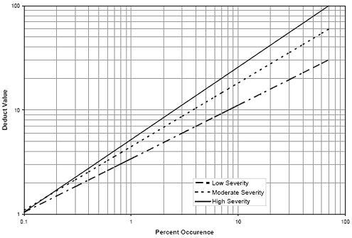
For the surface distress values of flexible pavements, all three severity levels for each distress type were combined through the use of deduct curves developed for the South Dakota Department of Transportation(10) to obtain a deduct value for each distress. The equations for these curves can be found in equations 2 through 4. Figure 2 provides a graphical representation of the low, moderate, and high severity deduct equations. The deduct values for the three severity levels were summed for each distress type and used in the regression analysis (i.e., equation 5).
| (2) |
| (3) |
| (4) |
| (5) |
| where : | |
| DL | low severity deduct value |
| DM | moderate severity deduct value |
| DH | high severity deduct value |
| DT | total deduct value |
| PL | recorded percentage of low severity distress |
| PM | recorded percentage of moderate severity distress |
| PH | recorded percentage of high severity distress |
Figure 2. Graph. Individual distress deduct curves.
Fatigue cracking (FC), block cracking (BC), longitudinal wheelpath cracking (LWP), and transverse cracking (TC) were considered in the study. All distress data for the flexible dataset were queried from the MON_DIS_AC_REV table. Because LWP often progresses to FC, the two distress types were combined (FWPC). LWP was converted from a linear unit to a unit of area to be consistent with FC. This was done by applying a standard width of 0.3 m (1 ft) to the recorded length of LWP. All severities of LWP were considered as low severity to compute deduct values that would be combined with the FC.
The recorded amounts of distress were converted into percentages (based on the total length or area of the test section). This was done to account for test sections with different lengths in the dataset. Percentages for FC and FWPC were determined based on the area of one wheelpath in the test section. The width of the wheelpath was assumed to be 1 m (3 ft). For BC, percentages by total area were used in the deduct equations, while the percentage of TC was based on the total length of the section.
It has been observed by various researchers, as well as the regional support contractors, that there is considerable variability in the rating of longitudinal wheelpath cracking and low severity fatigue cracking. A study by Rada, et al.(6) observed that compensatory differences exist among fatigue and longitudinal wheelpath cracking. That is, a reduction in one of these distress types generally coincides with an increase in the other type. For example, fatigue and longitudinal cracking values from section 080501 can be found in table 9. There is a reduction in fatigue cracking between 1996 and 1998 that is accompanied by an increase in longitudinal wheelpath cracking. The opposite is true between 1998 and 1999.
| Date | Total Fatigue Cracking (m2 (ft2)) | Total Longitudinal Wheelpath Cracking (m (ft)) |
|---|---|---|
| 26-Oct-94 | 0 (0) | 3.3 (10.8) |
| 12-Apr-96 | 114.7 (1234.6) | 0 (0) |
| 31-Jul-98 | 19.9 (214.2) | 180.3 (591.5) |
| 01-Sep-99 | 128.4 (1382.1) | 2.9 (9.5) |
In addition, in the beginning stages fatigue cracking generally appears as longitudinal cracking in the wheelpath (and is rated as such by surveyors). Over time, with repeated traffic loading, this cracking develops patterns indicative of fatigue; therefore, longitudinal wheelpath cracking values diminish as fatigue values increase. An example of this can be found in table 10. The longitudinal wheelpath cracking reduces with age as the fatigue cracking increases at section 068153 because the longitudinal cracking is progressing to fatigue cracking. Modeling these two distress types independently would result in significant variation within the regression.
| Date | Total Fatigue Cracking (m2 (ft2)) | Total Longitudinal Wheelpath Cracking (m (ft)) |
|---|---|---|
| 25-Nov-91 | 3.7 (39.8) | 86.6 (932.1) |
| 27-Jul-94 | 35.9 (386.4) | 53.3 (573.7) |
| 27-Jul-95 | 247 (2658.7) | 0 (0) |
For these reasons, fatigue and longitudinal cracking were combined. The combination provides a better indication of the damage in the wheelpaths because it is less variable and more consistent over time. This has improved the developed models.
The format of distress data collected on rigid pavements does not match the required format used in the established deduct curves;(8) therefore, the severity levels were summed for each distress type. This total distress was then normalized based on the size of the test section in the same manner as the flexible sections. For example, the sum of all three severities of longitudinal cracking were summed and divided by the total area of the section. Distress data were extracted from the MON_DIS_JPCC_REV table. Rigid distress types evaluated were longitudinal cracking (LC), transverse cracking (TC), corner breaking (CB), and pumping/water bleeding (PUMP). Pavement roughness was computed by averaging international roughness index (IRI) values from all runs available for each survey date and test section in the MON_PROFILE_MASTER table. Two forms of IRI were incorporated in the dataset for model development: change in IRI (DIRI) and absolute IRI (AIRI).
Many factors, such as construction techniques, existing geometrics, and material quality contribute to the roughness of newly constructed or rehabilitated pavements. In turn, initial pavement roughness significantly affects the accumulation of roughness as the pavement ages. To negate this variability from the models used to make performance comparisons in different climatic regions, DIRI values were computed based on initial roughness values. Roughness data at the completion of construction were not available for the test sections; therefore, the first recorded roughness value was used as the initial value. Subsequent measurements were subtracted from this value. The initial roughness value was also included in the dataset for reference. Using test section 481094 as an example, the first roughness measurement—average IRI of 0.875 meters per kilometer (m/km) (55.5 inches per mile (inches/mi))—was performed in March 1990, equating to a pavement age of approximately 14 years. Successive testing performed in September 1997 resulted in an average IRI of 0.963 m/km (61.1 inches/mi). The DIRI value reported in the dataset was 0.088 m/km (5.6 inches/mi) at age 21.
Alternatively, recorded IRI values in absolute terms (AIRI) were established as performance measures. However, to account for postconstruction variability, the MIRI and the age at which they were recorded (MIRI_AGE) were incorporated as explanatory variables in the regression analysis.
The air temperature recorded during profile data collection was also included as an explanatory variable for the roughness models in the rigid dataset. Temperature variations throughout the day cause warping and curling that can contribute to variations in roughness values.
Data from MON_T_PROF_INDEX_SECTION were queried to obtain rut depth information for the flexible dataset. This table contains computed rutting index parameters calculated from transverse profile information. The lane-width wire line rut index, which calculates the maximum rut depth (in each wheelpath) based on a wire line reference, was selected for use in this study. The reference is defined as a straight line between peak elevation points for each half of the lane.(3) Each time rutting was measured, rut depth values for both wheelpaths were averaged and incorporated into the analysis dataset (RUT).
Faulting values were extracted from MON_DIS_JPCC_FAULT_SECT for the rigid dataset. The values used for the study were average values of all faulting recorded at the transverse joints. The faulting measurements were taken in the outside wheelpath.
Multiple explanatory variables were included to account for the contribution of soils and material properties on pavement performance, and they consisted of: base material type (BASE); subgrade material type (SG); structural number (SN) for flexible pavements; asphalt layer thickness (ACTHICK) for flexible pavements; and slab thickness (D) for rigid pavements.
Materials classifications for base layers were grouped into six categories. Information from the TST_LO5B table was used to obtain material codes for base layers (i.e., layer description=5). Data in the TST_LO5B table are the most representative information in the LTPP IMS Pavement Performance Database regarding pavement layering because it is derived primarily from laboratory test results. Table 11 lists each BASE category as well as the material codes used to define the category. Complete details on material code classifications can be found in Operational Guide No. SHRP-LTPP-OG-004.(11) Each test section was assigned a base type category as an explanatory variable. Each of the BASE categories established have significantly different characteristics (i.e., drainage, strength/in-situ moisture relationships), which directly effect the rate at which pavements deteriorate. In some cases multiple base layers existed in the pavement structure. Guidelines were established and they are provided in table 12 to assign BASE categories for these situations.
Similarly, material code classifications of subgrade layers (layer description=7) were extracted from TST_LO5B and grouped into three categories. Test sections with material codes between 100 and 178 were assigned a FINE subgrade type. All of these material codes correspond to material that has at least 50 percent passing the 0.075 millimeters (mm) (No. 200) sieve. Subgrade layers consisting of materials codes 200 to 267 were categorized as a COARSE subgrade. These material codes represent soils with less than 50 percent passing the 0.075 mm (No. 200) sieve. The third subgrade type established for this study was labeled ROCK/STONE and includes "naturally formed solid mineral matter occurring in large masses, and naturally or crushed angular particles of rock."(11)
The type of subgrade material can make a large contribution to the performance of pavement structures. Fine-grained materials become very weak with excess moisture, and are susceptible to frost heave.
For flexible pavements, structural capacity is most commonly defined in terms of SN. Methods detailed in SHRP-LTPP Technical Memorandum AU-167(12) were used to calculate SN values. The memo defines structural coefficients for each combination of material classification code and layer description. This coefficient was used in conjunction with layer thickness to obtain structural number. The method does not incorporate drainage coefficients to adjust structural capacity. Both material classification codes and layer thicknesses were extracted from the TST_LO5B table. If either the material classification code or the layer thickness was unavailable or unreasonable, data from agency project records, which are located in rehabilitation (RHB_LAYER) and inventory (INV_LAYER) tables, were used.
For rigid pavements, SN is not a valid parameter, and is replaced by slab thickness in design procedures.(13) As such, D was included as an explanatory variable in the dataset. Thickness values were extracted from the TST_LO5B table for surface layers (layer description=3).
| BASE Category | BASE Description | Material Code | Material Code Description |
|---|---|---|---|
| DGAB | Unbound Base | 302 | Gravel (uncrushed) |
| 303 | Crushed stone | ||
| 304 | Crushed gravel | ||
| 305 | Crushed slag | ||
| 306 | Sand | ||
| 307 | Soil-aggregate mixture (predominantly fine-grained) | ||
| 308 | Soil-aggregate mixture (predominantly coarse-grained) | ||
| 309 | Fine-grained soils | ||
| ATB | Asphalt Treated Base | 319 | Hot mix asphalt concrete (HMAC) |
| 320 | Sand asphalt | ||
| 321 | Asphalt treated mixture | ||
| 322 | Dense graded, hot laid, central plant mix | ||
| 323 | Dense graded, cold laid, central plant mix | ||
| 324 | Dense graded, hot laid, mixed in-place | ||
| 328 | Recycled asphalt concrete, plant mix, hot laid | ||
| 329 | Recycled asphalt concrete, plant mix, cold laid | ||
| 330 | Recycled asphalt concrete, mixed in-place | ||
| PATB | Permeable Asphalt Treated Base | 325 | Open graded, hot laid, central plant mix |
| 326 | Open graded, cold laid, central plant mix | ||
| 327 | Open graded, cold laid, mixed in-place | ||
| NONBIT | Nonbituminous Treated Base | 331 | Cement aggregate mixture |
| 332 | Econocrete | ||
| 333 | Cement-treated soil | ||
| 335-360 | Includes treated soils (e.g., lime, calcium chloride) | ||
| LCB | Lean Concrete Base | 334 | Lean concrete |
| NONE | No Base | N/A | No layer description=5-inch layer structure |
| Existing Base Layer Combinations | BASE Category Assigned |
|---|---|
| ATB/DGAB | ATB |
| PATB/ATB | PATB |
| PATB/DGAB | PATB |
| NONBIT/DGAB | NONBIT |
| LCB/NONBIT | LCB |
| NONBIT/ATB | Sections removed from dataset (if present) |
| NONBIT/PATB | Sections removed from dataset (if present) |
| LCB/ATB | Sections removed from dataset (if present) |
| LCB/PATB | Sections removed from dataset (if present) |
In addition, the total thickness of the AC binder course layers (layer descriptions 1, 3, and 4) was also calculated and included as an explanatory variable in the dataset. Again, data in the TST_LO5B table were used to determine these values.
To summarize all of the soil and material property variables discussed previously, TST_LO5B information from test section 481094 is provided as an example in table 13 along with structural coefficients from SHRP-LTPP Technical Memorandum AU-167.(12)
The material classification code for the base layer (layer description 5) is 303; therefore, the BASE category dense graded aggregate base (DGAB) was assigned to test section 481094. The subgrade explanatory variable for this section was designated as COARSE because of the material code classification of 214 for the subgrade layer. The SN calculation provided in table 12 resulted in an SN of approximately 2.01.
Last, two AC binder course layers are present in the pavement structure with thicknesses of 1.2 and 0.7 (layers 3 and 4, respectively); therefore, the ACTHICK value was computed as 1.9 for this section.
| Layer | Layer Description from TST_LO5B | Material Code from TST_LO5B | Structural Coefficient from AU-167 (a) | Layer Thickness from TST_LO5B (D) (mm (inch)) | Structural Contribution (a*D) |
|---|---|---|---|---|---|
| 1 | 7 | 214 | 0 | NA | 0 |
| 2 | 5 | 303 | 0.14 | 213 (8.4) | 1.176 |
| 3 | 4 | 1 | 0.44 | 31 (1.2) | 0.528 |
| 4 | 3 | 1 | 0.44 | 18 (0.7) | 0.308 |
| Total | 2.012 | ||||
| Note: a= structural coefficient, D=layer thickness, a*D=structural coefficient multiplied by layer thickness |
Traffic data are one of the most significant factors affecting pavement performance. Equivalent single axle load (ESAL) values provide a representative value of the traffic loading experienced by a pavement structure. Equivalent axle load factor (EALF) values were computed using equations set forth in the American Association of State Highway and Transportation Officials (AASHTO) Guide for Design of Pavement Structures.(13) Values of SN or D, discussed previously, were inputs for the calculation of EALF. In turn, the EALF values were used to convert weight bin data from the TRF_MONITOR_AXLE_DISTRIB table to ESALs. Values were averaged over all available years in the dataset. If monitored traffic data were unavailable, data from the estimated traffic (TRF_MON_EST_ESAL) table were used. These estimations are provided by the SHA.
It is recognized by the analysis team that traffic load spectra has been introduced to represent loading conditions for design purposes; however, the tools to apply load spectra from LTPP data were not readily available at the onset of the project.
To provide an indication of the structural capacity of the pavement relative to the amount of loading experienced, a ratio of SN and logarithm of ESALs was computed. Pavement performance is highly dependent on the relationship between these two. For example, the amount of alligator cracking is directly related to both the magnitude of loading and the overall strength of the pavement structure. Therefore, the ratio could be used to determine if differences in performance are related to frost conditions or are a consequence of the improper pairing of pavement strength and loading. A similar ratio was computed for rigid pavements with the exception that SN was replaced with slab thickness. The logarithmic relationship of ESALs was applied in both ratios to reflect the processes outlined in the 1993 AASHTO Guide for Design of Pavement Structures.(1) The design charts in the design guide correlate accumulated damage to ESAL values using a logarithmic relationship. The SN or D values are integrated into the design equations using a linear relationship
In addition, the functional classification for each test section was included in the roughness datasets (both absolute and change in roughness). This factor was included to account for differences in the initial smoothness of the sections due to a range of construction smoothness specifications.
Criteria were established to select test sections to be used in the development of regression models. This was to reduce variability within the dataset and improve the resultant models.
The first condition was set forth in the statement of work for the project, which stated that performance comparisons would be made with sites that are located in:
…the southern reaches of the wet-freeze zone or the northern reaches of the wet no-freeze zone versus those sites that are farther north in the wet freeze zone. Contrast these findings with pavement performance in the dry freeze and wet no-freeze climatic regions.Therefore, only sections located in the wet freeze, wet no-freeze, and dry freeze regions were included in the analysis. While climatic differences were accounted for as explanatory variables, only data from the regions of interest for this study were included.
In addition, to limit the variability of the performance data within the dataset, the TST_LO5B table was used to identify and remove test sections with surface treatments such as slurry and chip seals. Routine applications of surface treatments significantly reduce the progression of pavement deterioration. These treatments mask the surface of the pavement, thus improving performance measures such as pavement roughness and surface distress. If these test sections would have been included in the study, additional explanatory variables would have been required to properly account for their effect.
Test sections with unavailable or questionable explanatory data were also removed from the analysis dataset. For example, the computed 1994 annual ESAL value for test section 124109 was approximately 47.8 million. This value is very unreasonable, and the average ESAL value used in the dataset was computed using all other available years except 1994.
The resultant datasets consisted of more than 520 test sections for flexible pavements and over 270 test sections for rigid pavements. Between 2,500 and 4,500 observations (depending on the performance measure) were included to develop the flexible models. The number of observations for the rigid dataset ranged from 1,400 to 2,700. The size of the dataset is adequate to properly incorporate the relatively large number of variables required in the study. In addition, the number of test sections ensures pavements exposed to a wide range of conditions are represented in the models.

