U.S. Department of Transportation
Federal Highway Administration
1200 New Jersey Avenue, SE
Washington, DC 20590
202-366-4000


Skip to content
Facebook iconYouTube iconTwitter iconFlickr iconLinkedInInstagram

Federal Highway Administration Research and Technology
Coordinating, Developing, and Delivering Highway Transportation Innovations

Report
This report is an archived publication and may contain dated technical, contact, and link information
Publication Number: FHWA-RD-01-164
Date: March 2002

Appendix A – Field Data Collection Forms

Previous | Table of Contents | Next

Field Survey Equipment Checklist

Item

Check mark

Measuring Wheel


Marking Paint


Faultmeter


Ruler/Scale


Pocket Knife


Clipboard/Pencils


Water Spray Bottle


Magnifying Glass


Camera or Camcorder (with extra film/tapes)


Flashing Warning Light


Safety Vests and Hard Hats


LTPP Distress Identification Manual


Project Location


Local Contact Name/Number


Graphic. General project information form. This form is used to note general information about a project and is divided into four sections.  The top of the page has a section for recording project specific information such as project ID and County, as well as climatic information for the project zone. The second section is for project identification, with places to note the project's general location and type of roadway. Project and Section Location is the third section and is for denoting the project's exact location based on mile posts and other details. The last section on the form is about project design and is for denoting information such as pavement type, thickness, and joint spacing.


Graphic. Concrete mixture design information form.  This form is used to identify PCC mix design information and has four sections to input the following information: Project ID, details about the cementitious materials, PCC mixture design specifications, and admixture sources, types, and rates.

Graphic.  Concrete fine aggregate information form. This form is for recording information specifically about the concrete fine aggregate. There are three sections. At the top is a section for general project information. This is followed by a section for information on the first fine aggregate used with space to indicate the unit weight, absorption, gradation, specific gravity, performance, etc. The third section is the same as the second and is needed only if two fine aggregates are used for the project.


Graphic.  Concrete coarse aggregate information form. This form is used for recording information specifically about the concrete coarse aggregate. There are three sections. At the top is a section for general project information. This is followed by a section for information on the first coarse aggregate used with space to indicate the unit weight, absorption, gradation, specific gravity, performance, etc. The third section is the same as the second and is needed only if two coarse aggregates are used for the project.

Graphic. Construction information form.  This form is used to record relevant construction information and as four sections. General project information is recorded at the top, followed by sections for information on the mixing plant, the construction truck, the mix properties used during construction, and the climatic conditions during paving mixing.
Graphic.  Field survey data collection form.  This form is used while conducting the pavement distress survey. Instructions are provided at the top of the form, along with an area for noting general project information. Below this are two grids for sketching a picture of the project area. The grids represent a 31 meter wide by 5 meter tall area, but is divided at the 15 meter mark to make two separate grids, one on top of the other.


Graphic.  Modified LTPP distress summary form. This form is used to record overall pavement distress data in a tabular format. At the top of the form is an area to record general project information. Below this is a table to record the distress severity and any comments about the distress.  The table is divided into five sections with one for the location of each type of distress-cracks, the longitudinal joints, the transverse joints, at the surface, and on other parts.

Graphic.  Survey form for illustrating typical MRD. This form is used to note typical slab MRD manifestations. At the top is a place to record common project information. The instructions found below the general information section indicate that a scale and sketch should be made of the slab including the typical crack pattern and location. Below this is a space to draw the sketch.
Graphic.  MRD characterization form.  This form is used to categorize the MRD in terms of its cracking pattern including location, shape, and size.  Separate spaces are provided for different types of MRD and space is provided at the top of the page to record general project information.

Go to Alternative Text link to this image or the text link below

Alternative Text for Flowchart

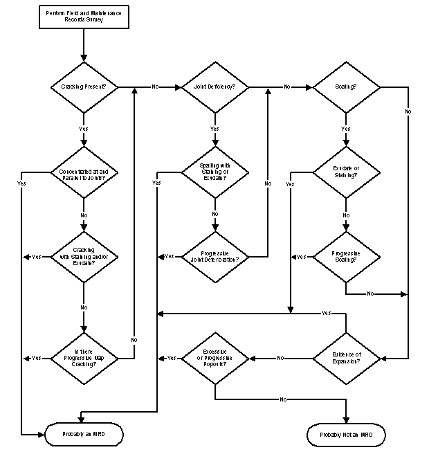
Flowchart for Assessing Likelihood of MRD

LABORATORY LOG OF PCC PAVEMENT CORES

Sheet ____ of ____

Project Designation: State: Highway:

Nearby City and Distance: Direction:

No. of Through Lanes (in direction sampled): Lane Sampled:

Beginning Milepost/Station: End Milepost/Station:

Operator: Core Diameter:

Coring Date: Core Barrel Tip Type:

Job ID:

Note: Each column shown below should be used to record information for all cores/pieces extracted from a single panel. “Depth” should be measured from the pavement surface to the bottom of the core/piece and recorded to the nearest 2 mm. Front direction is the direction of traffic.

CORE NUMBER

A

B

C

D

E

Other

CORE ID


LOCATION/STATION


Offset From Joint


Offset From Shoulder


Number of Pieces?


Core Piece No. 1


Position
(Left, Right, Back, Front of core)


Depth (mm)


Core Piece No. 2


Position
(Left, Right, Back, Front of core)


Depth (mm)


Core Piece No. 3


Position
(Left, Right, Back, Front of core)


Depth (mm)


Core Piece No. 4


Position
(Left, Right, Back, Front of core)


Depth (mm)


Remarks


Graphic.  Example core identification label.  This is the label that should be affixed to each sample. The label has space to record general core information, the core identification code, a sample sketch, and comments.


Previous | Table of Contents | Next

Federal Highway Administration | 1200 New Jersey Avenue, SE | Washington, DC 20590 | 202-366-4000
Turner-Fairbank Highway Research Center | 6300 Georgetown Pike | McLean, VA | 22101