China Earthquake Reconnaissance Report: Performance of Transportation
Structures During the May 12, 2008, M7.9 Wenchuan Earthquake
EARTHQUAKE AND SURFACE RUPTURES
THE MAY 12, 2008, WENCHUAN EARTHQUAKE
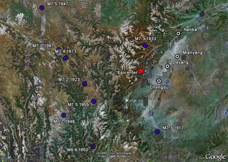
The M7.9 Wenchuan earthquake occurred at 6:28:01 (UTC) on May 12, 2008, in the Longmen-Shan thrust zone. Its epicenter was located at 30.989 °N, 103.329 °E, near Yingxiu in Wenchuan County, Sichuan Province. The focal depth of the earthquake was approximately 6.21 mi (10 km), and the highest recorded peak ground acceleration was 0.65 g (6.37 m/s2). At least 35 aftershocks with magnitudes equal to or greater than M5.0 were recorded within the first three months after the main shock, with the strongest aftershock of M6.4 (M6.5 according to CEA). This region has frequently experienced large earthquakes, as indicated in table 1 and figure 4.(1) The last earthquake over M7.0 prior to the Wenchuan earthquake occurred in 1973.
Table 1. Significant Longmen-Shan Earthquakes, M ≥ 7.0.
Year |
Month |
Day |
Time |
Latitude |
Longitude |
Depth |
Magnitude |
1917 |
07 |
30 |
2354 |
29.000 |
104.000 |
0 |
7.3 |
1923 |
03 |
24 |
1240 |
30.553 |
101.258 |
25 |
7.2 |
1933 |
08 |
25 |
0750 |
31.810 |
103.541 |
25 |
7.3 |
1947 |
03 |
17 |
0819 |
33.000 |
99.500 |
0 |
7.5 |
1948 |
05 |
25 |
0711 |
29.500 |
100.500 |
0 |
7.2 |
1950 |
08 |
15 |
1409 |
28.500 |
96.500 |
0 |
8.6 |
1955 |
04 |
14 |
0129 |
29.981 |
101.613 |
10 |
7.5 |
1967 |
08 |
30 |
0422 |
31.631 |
100.232 |
8.1 |
7.0 |
1973 |
02 |
06 |
1037 |
31.361 |
100.504 |
6.6 |
7.4 |
© Google, Europa Technologies, and TerraMetrics
Figure 4. Map. Historical Earthquake Activity.
The Longmen-Shan thrust zone was formed by the Eastern Tibetan Plateau pushing against the Sichuan Basin.(2) The thrust zone has three faults: the front fault (Guanxian-Jiangyu-Guangyuan), the center fault (Yingxiu-Beichuan-Chaba-Linjueshi), and the back fault (Wenchuan-Maoxian-Qingchuan). Based on the distribution of aftershocks, approximately 186 mi (300 km) of faults ruptured, breaking the ground surface along the Yingxiu-Beichuan segment of the center fault (130 mi (210 km)) and along the Guanxia-Jiangyu segment of the front fault (43.5 mi (70 km)). According to Xie et al., vertical fault displacements over 16.4 ft (5 m) were measured.
The M7.9 Wenchuan earthquake and several strong aftershocks resulted in massive landslides and rockfalls. These events caused approximately 70,000 fatalities and economic losses of over $110 billion. They damaged more than 1,000 bridges, approximately 20 of which had to be replaced. The severity of bridge damage greatly increased with proximity to the fault, with the worst damage occurring in mountainous terrains. This made the recovery more difficult. Most mountain roads are switchbacks with steep grades over narrow passes with little room for detours. Massive landslides covered or undermined the roads, making it difficult to transport equipment and supplies.
SURFACE FEATURES OF FAULT RUPTURE AT THE EARTHQUAKE EPICENTER
The epicenter of the earthquake was located near Yingxiu in Wenchuan County, Sichuan Province. The surface rupture of the center fault in the Longmen-Shan fault zone was observed in Yingxiu, as illustrated in figure 5. The thrust fault appeared to cross the Ming River at a right angle. The earthquake left behind a distinct dislocation on the river bed at the northeast end of the surface rupture. The northwest side of the fault, on the upstream of the river, moved upward against the southeast side of the fault. The fact that one deck panel along the elevated expressway bridge was still supported by one pier indicated the sudden push by a near-field pulsing effect. The line on figure 5 traces the surface rupture features: a sudden slope change in the mountain, buildings that were damaged next to collapsed buildings, and dislocation across the river bed.
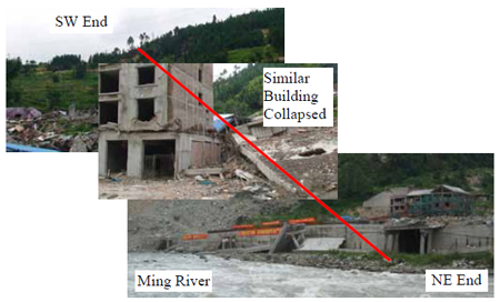
Figure 5. Photo. Surface Rupture of the Earthquake Fault.
On one side of the Ming River was a five-story building with a construction joint between two similar parts. The right side of the building was completely collapsed while the left side of the building only lost the second story and suffered structural damage in the walls. A sudden change was also apparent on the slope of the mountain behind the building. A closer look at the Dujiangyan-Wenchuan highway in front of the building indicated that the vertical dislocation was approximately 4.92 ft (1.5 m), as shown in figure 6.
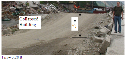
Figure 6. Photo. Surface Rupture Along the Old Highway Near a Collapsed Building.
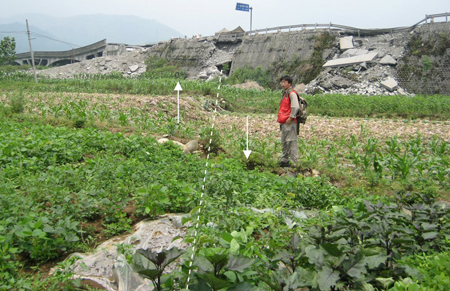
SURFACE FEATURES OF FAULT RUPTURE NEAR XIAOYUDONG BRIDGE
Xiaoyudong Bridge is located at 31.1859 °N, 103.7677 °E between the front and center faults in the Longmen-Shan fault zone. Part of the bridge structure collapsed, and the rest suffered significant damage. According to Xie et al., surface rupture was observed at the bridge site, as shown in figure 7 and figure 8. The vertical offset was more than 3.28 ft (1 m). The highest peak ground acceleration recorded during the Wenchuan earthquake, 0.65 g (6.37 m/s2), was measured near Xiaoyudong Bridge, at a point to its northeast.
Source: Dr. Zhenming Wang, Kentucky Geological Survey, University of Kentucky
Figure 7. Photo. Surface Rupture Near Xiaoyudong Bridge.
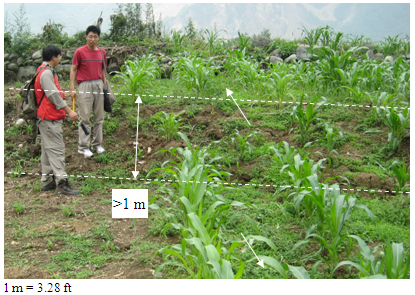
Source: Dr. Zhenming Wang, Kentucky Geological Survey, University of Kentucky
Figure 8. Photo. Surface Rupture Away From Xiaoyudong Bridge.
|


