U.S. Department of Transportation
Federal Highway Administration
1200 New Jersey Avenue, SE
Washington, DC 20590
202-366-4000
Federal Highway Administration Research and Technology
Coordinating, Developing, and Delivering Highway Transportation Innovations
 |
| This fact sheet is an archived publication and may contain dated technical, contact, and link information |
|
Publication Number: FHWA-HRT-07-030
Date: January 2007 |
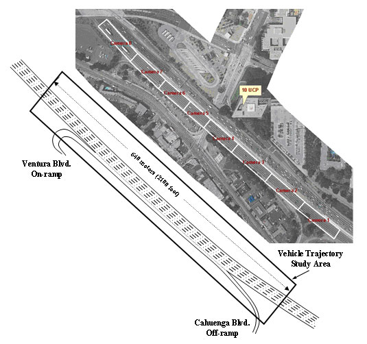
US Highway 101 DatasetPDF version of Fact Sheet (171 KB) To support the development of algorithms for driver behavior at microscopic levels, the Next Generation SIMulation (NGSIM) computer program is collecting detailed, high-quality traffic datasets. NGSIM stakeholder groups identified the collection of real-world vehicle trajectory data as important to understanding and researching driver behavior at microscopic levels. The NGSIM datasets represent the most detailed and accurate field data collected to date for traffic microsimulation research and development. The US Highway 101 (US 101) dataset was one of several datasets collected under the NGSIM program. DescriptionResearchers for the NGSIM program collected detailed vehicle trajectory data on southbound US 101, also known as the Hollywood Freeway, in Los Angeles, CA, on June 15th, 2005. The study area was approximately 640 meters (2,100 feet) in length and consisted of five mainline lanes throughout the section. An auxiliary lane is present through a portion of the corridor between the on-ramp at Ventura Boulevard and the off-ramp at Cahuenga Boulevard. Eight synchronized digital video cameras, mounted from the top of a 36-story building adjacent to the freeway, recorded vehicles passing through the study area. NG-VIDEO, a customized software application developed for the NGSIM program, transcribed the vehicle trajectory data from the video. This vehicle trajectory data provided the precise location of each vehicle within the study area every one-tenth of a second, resulting in detailed lane positions and locations relative to other vehicles. A total of 45 minutes of data are available in the full dataset, segmented into three 15 minute periods: 7:50 a.m. to 8:05 a.m.; 8:05 a.m. to 8:20 a.m.; and 8:20 a.m. to 8:35 a.m. These periods represent the buildup of congestion, or the transition between uncongested and congested conditions, and full congestion during the peak period. In addition to the vehicle trajectory data, the US 101 dataset also contains computer-aided design and geographic information system files, aerial ortho-rectified photos, loop detector data, raw and processed video, weather data, and aggregate data analysis reports. The full US 101 dataset is freely available at the NGSIM Web site at http://ops.fhwa.dot.gov/trafficanalysistools/ngsim.htm. BenefitsTravelers in freeway merge areas face complex tasks in executing their short term trip plans. They must accelerate to the predominant through speeds, check for acceptable gaps, and position themselves for their next maneuvers. During medium and heavy congestion, these tasks are complicated by the volume of other travelers competing for space on crowded freeways. In reality, travelers often overcome some of this complexity by cooperating with other drivers. Existing microsimulation models generally use basic or modified versions of lane changing models to model freeway merging behaviors. While these models do account for gaps created by adjacent vehicles, and in some cases model reduced gap acceptance thresholds during congested conditions, the models do not explicitly account for cooperation among drivers. As a result, existing models tend to overpredict congestion because the models fail to capture localized system optimization that occurs when drivers exhibit cooperative behaviors. NGSIM researchers used the US 101 dataset to develop and validate a new driver behavior model, the Cooperative/Forced Freeway Merge model, which models lane changing on a freeway merge and weaving section that treats driver cooperation explicitly.
NGSIM researchers also used the US 101 dataset to develop and validate the Freeway Lane Selection and Oversaturated Freeway Flow models. The dataset enabled NGSIM researchers to understand the core driver behaviors for these models, namely oversaturated freeway traffic movements and freeway lane selection and distribution, at a level of detail and accuracy not available previously. These high-quality algorithms can be incorporated into traffic microsimulation models, which will help transportation practitioners make more reliable and valid transportation decisions. The US 101 data also can be used to study weaving sections, freeway-surface street interchanges, freeway geometric effects, capacity effects of ramp metering, and auxiliary lane design. For more information, visit the NGSIM website at http://ops.fhwa.dot.gov/trafficanalysistools/ngsim.htm or contact: James Colyar John Halkias Publication No. FHWA-HRT-07-030 PDF files can be viewed with the Acrobat® Reader® |
|
Updated: 09/08/2017
|