U.S. Department of Transportation
Federal Highway Administration
1200 New Jersey Avenue, SE
Washington, DC 20590
202-366-4000
Federal Highway Administration Research and Technology
Coordinating, Developing, and Delivering Highway Transportation Innovations
 |
| This report is an archived publication and may contain dated technical, contact, and link information |
|
Publication Number: FHWA-HRT-04-109
Date: September 2004 |
University: University of Utah, Cooperative Institute for Regional Prediction
Principal Investigators: John Horel, Mike Splitt, CIRP
NWS WFO: Salt Lake City, UT
Name of Primary NWS Collaborator: Larry Dunn
DOT Office: Utah Department of Transportation
Name of Primary DOT Collaborators: Ralph Patterson, and formerly Steve Conger
Cooperative Project, UCAR Award No.: S01-24244
This study expanded work originally funded by the Utah Department of Transportation (UDOT), "Implementing Roadway Weather Information Support Management of Winter Maintenance," UDOT Contract No. 98-8298. That project helped coordinate and identify weather resources in Utah pertinent to winter road maintenance. Results from that study were presented at a special session on the RWIS at the AMS Interactive Information and Processing Systems Conference (IIPS).(4) As a result of previous work, researchers began this project having worked toward several of the objectives of the FHWA, NWS and COMET programs. For example, they had already established cooperative working relations between State DOTs, the university community, and WFOs. They also had fostered an open repository of RWIS observations that were integrated with other weather observations around the West as part of the MesoWest project.(5)
The specific goals of this project were to:
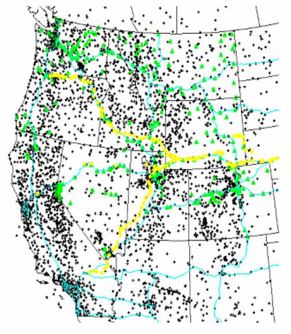
A major accomplishment of this project was to continue to facilitate and improve access to RWIS observations in the western United States. Figure 25 shows the locations of RWIS stations from which weather information is obtained routinely (additional road state information is available from many of these stations, as well). Researchers currently collect,archive, and disseminate RWIS information from stations in California, Colorado, Idaho, Montana, Nevada, Oregon, Utah, Washington, and Wyoming, for a total of 6,000 stations in the West.
 |
|
Figure 25. Locations of MesoWest stations (plus symbols), RWIS stations (green triangles), and Union Pacific Railroad stations (yellow diamonds). |
The scope of data collection efforts expanded as opportunities to collaborate with State DOTs developed. This component of the study represents the largest fraction of effort. The following summarizes this ongoing data collection effort.
California: The Meteorologist-in-Charge at the Eureka, CA, WFO provided the initial contact with the California Department of Transportation (CalTrans) representatives in northern California to facilitate access to 11 stations along I-5 north of Redding, CA. Updates every 30 minutes are available via ftp.
Colorado: NOAA Forecast Systems Laboratory (FSL), as part of the Meteorological Assimilation Data Ingest System (MADIS), in cooperation with the Boulder, CO, WFO, provides access to Colorado DOT observations from 55 stations. The data are distributed via Unidata's Local Data Manager (LDM). In addition, winter road maintenance observations in support of avalanche control work are collected in cooperation with the Grand Junction, CO, WFO. As part of this project, researchers helped install software at the Grand Junction WFO to dial weather stations at several mountain passes, and researchers continue to help the WFO troubleshoot problems in data collection as they occur.
Idaho: Part of this project involved considerable effort to develop software to collect RWIS data (weather and road state) from the Idaho Transportation Department (ITD). This initially involved writing software and installing that software on an ITD computer. ITD now has installed a system to collect the data, which is accessed via ftp. ITD depends on MesoWest for access to real-time weather information for its Road Weather Integrated Data System (see http://164.165.237.41/RWIDS_Public/default.asp). Activities as part of this project in support of ITD were second only to that provided to the UDOT.
Montana: The Montana Department of Transportation (MDT) and Great Falls, MT, WFO have collaborated for years to share weather and road state information. Researchers obtain the weather and road state data from 59 stations via LDM and have worked with MDT personnel to identify data quality problems as they become evident.
Nevada: Data from 47 stations in Nevada are obtained via ftp from NDOT. Staff at the DRI and the Reno, NV, WFO have facilitated this work.
Oregon: Staff at the Pendleton, OR, WFO helped facilitate access to weather information at 28 stations supported by the Oregon Department of Transportation (ODOT). The weather information is collected via access to the DOT Web server.
Utah: Researchers worked closely with UDOT to facilitate access to weather and road state information at 53 locations around the State. Information is collected directly via ftp from a RWIS server supported by UDOT, as well as through a computer at the Salt Lake City, UT, WFO.
Washington: Weather and road state information are collected from 72 stations maintained by the Washington State Department of Transportation (WSDOT). These data are accessible as a result of the efforts of staff at the Seattle, WA, WFO and the University of Washington. The data is collected via ftp from the University of Washington.
As shown in figure 25, researchers obtained access to weather information at 264 locations along the major Union Pacific rail corridors in the West. Most of the stations report temperature only (to detect track contraction/expansion), and wind conditions are reported at many critical locations.
Because MesoWest was a well-established database, researchers were experienced in handling data in a variety of formats and implementing a quality control program. Quality control procedures based on three-dimensional linear regression have been implemented to assess temperature, dewpoint temperature, and pressure. Researchers improved simple checks for wind data (gust to sustained wind ratio, for example) so that poor wind observations could be identified. Precipitation is the most difficult to manage; this was left to the data providers.
The NWS, UDOT, and University of Utah worked closely to provide weather and road state information as well as forecasts to Olympic organizers, public safety personnel, and the public for the 2002 Winter Olympics and Paralympics.(6) Many different representatives of organizations related to the Olympics judged these efforts to be highly successful. Formal evaluation of the NWS weather forecasts issued along the transportation corridors was not pursued.
A specialized Web interface to the MesoWest database (www.met.utah.edu/mesowest) was developed and maintained for UDOT personnel to use. This interface has been used extensively for winter road maintenance as well as road construction and summer paving projects. An example of the summary of current conditions is provided in figure 26.
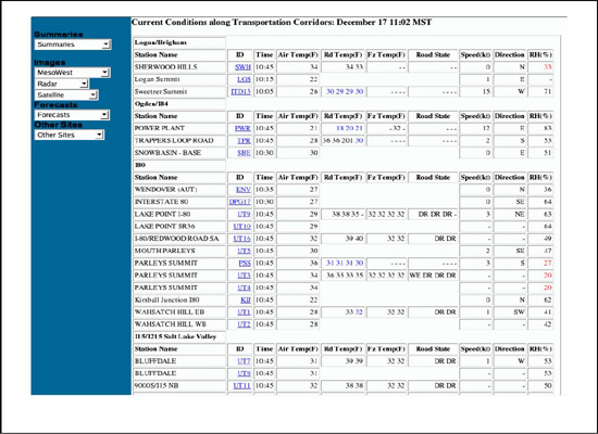 |
| Figure 26. Summary of current weather and road state in Utah available in MesoWest. |
Researchers developed anisotropic weighting functions for the ADAS data assimilation system.(7) These anisotropic weights are critical to resolving a systematic source of error in the analyses where weather observations in one valley affect the analysis in adjacent valleys.(8) This error is particularly problematic because a forecast model at very high resolution will resolve the weather in adjacent valleys independently. However, observation corrections to the initial background field obtained from a model can bleed laterally through the terrain. This affected the suitability of the analyses along some transportation corridors.
The NWS is interested in data assimilation efforts over complex terrain to initialize and validate Integrated Forecast Preparation System (IFPS) gridded forecasts at WFOs around the West. The support from COMET helped develop ADAS further for these applications.
In part as a result of the increased data collection efforts, less effort was placed on evaluating the utility of RWIS observations in the decision making process. Questionnaires were distributed to winter maintenance personnel during the 2001 winter season to collect information on the utility of local RWIS data. Preliminary analysis of data collected from shed foremen in Idaho, Montana, and Utah during the following spring was inconclusive; therefore, this effort was suspended for the 2002 winter season.
Access to RWIS data in some States was difficult to obtain. Researchers were not able to develop contacts at the CalTrans district level in many parts of California, waited several years to access RWIS data from Arizona, and have not identified an appropriate contact in New Mexico.
The greatest level of interaction between the Salt Lake City, UT, WFO, UDOT, and University of Utah took place during the first year of the project as a result of the need for preparation and coordination of research, development, and operations for the 2002 Winter Olympics and Paralympics. The interaction was very positive and beneficial to all three organizations. A major goal of the Olympic weather support effort was to provide a legacy of improved understanding of winter storms and enhanced capabilities to predict weather in the region. This legacy is in place in part because of projects such as this.
The FHWA/NWS COMET program provided a framework to approach State DOTs to share weather and road state information. However, support to sustain this effort is unclear. Ways to sustain this effort are being explored initially with UDOT and ITD through their participation in the Cooperative Institute for Regional Prediction (CIRP) Consortium. CIRP has developed innovative tools to conduct research and assist government and commercial operations that are sensitive to weather around the Nation, in part with funding from research and development efforts supported by the NWS, FHWA, and other agencies. These tools include MesoWest, which provides real-time monitoring and analysis of environmental conditions, and the authors' data assimilation and modeling efforts. The CIRP Consortium was established to further develop and apply these tools for the unique environmental problems of the Intermountain West and other regions of the Nation. The consortium is intended to provide support for the continued real-time operations of MesoWest and provide the foundation for further applied research and development related to real-time weather and emergency management operations, air quality, fire weather, winter road maintenance, wind power, and water resource management. The CIRP Consortium is modeled after the Northwest Regional Modeling Consortium developed at the University of Washington.
The initial feedback from UDOT and ITD to the Consortium funding approach is favorable. However, is it reasonable to expect those States to fund researchers' efforts to access weather and road state information in other regions of the West? There is a clear need for FHWA and NWS to support data collection efforts on a national scale that relies, in part, on the local partnerships that already exist in some regions of the country.
Further research is also required to improve the utility of local analysis and forecast grids for road weather applications. The NDFD under development by the NWS potentially provides a tool to improve road weather decision-making. However, a number of technical issues must be resolved regarding how to best to use that information.

