U.S. Department of Transportation
Federal Highway Administration
1200 New Jersey Avenue, SE
Washington, DC 20590
202-366-4000
Federal Highway Administration Research and Technology
Coordinating, Developing, and Delivering Highway Transportation Innovations
 |
| This report is an archived publication and may contain dated technical, contact, and link information |
|
Publication Number: FHWA-HRT-04-131
Date: September 2004 |
Adverse weather conditions can have a dramatic impact on the operations and quality of traffic flow. For example, icy pavement conditions can affect the acceleration and deceleration capabilities of vehicles. Reduced visibility can cause drivers to alter their desired speed,how they change lanes, and how they follow other vehicles. Major weather events can cause drivers to modify their travel patterns, such as taking a different route to a destination, leaving for a destination at a different time than normal, or canceling a trip altogether.
With the advent of ATMS, there is an opportunity to develop traffic management strategies that attempt to minimize the negative weather-related impacts on traffic operations. For instance, a weather event that reduces the average operating speed on an arterial can be mitigated by quickly implementing traffic signal plans that account for the lower speeds while still maintaining progression through a network. However, to develop and implement strategies that minimize the effects of adverse weather conditions, a more complete knowledge of how weather events affect traffic operations and how to assess the weather-related effects for a given scenario is needed.
Currently, the relationship between weather events and traffic operations is moderately understood, but only at a macroscopic analysis level, such as the methodologies presented in the Highway Capacity Manual (HCM). [1](2) Using an HCM-style analysis is, in fact, one way to model weather impacts to develop weather-responsive traffic management strategies. However, a more detailed and potentially more accurate method is to use a microscopic traffic simulation model. A microscopic simulation tool can model individual vehicles on a roadway network, typically on a second-by-second basis or less. Simulation models have the benefit of being able to model complex roadway geometries, traffic control devices, and vehicle configurations that are beyond the limitations of a macroscopic HCM-style analysis.
However, modeling microscopic driver behavior is difficult under ideal weather conditions, let alone under adverse weather conditions. Little research has been conducted on how weather events impact microscopic driver behavior logic, such as lane changing and vehicle following, both of which are crucial to the accuracy of a microscopic traffic simulation model. In addition, a vast number of user-input parameters within simulation models can be altered. Knowing which key parameters within a microsimulation model should be changed under various weather conditions would aid greatly in developing weather-responsive traffic management strategies.
The objectives of this study are to identify how weather events impact traffic operations, assess the sensitivity of weather-related traffic parameters in the CORSIM traffic simulation model, and develop guidelines for using the CORSIM model to account for the impacts of adverse weather conditions on traffic operations. More specifically, this study is tasked to do the following:
This study, which began in September 2002, was conducted on a task order basis with a total of five tasks. Figure 1 shows a flowchart of the task breakdown and workflow. As shown in this figure, the tasks were completed in consecutive order, because the output from one task was required for the next task. This report provides the results for each of these tasks.
Develop Guidance on Using CORSIM to Model Weather Events
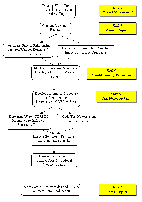
Figure 1. Study Approach.
This report represents the final task (Task E in figure 1) for the "Identifying and Assessing Key Weather-Related Parameters and Their Impacts on Traffic Operations Using Simulation" project. This report is separated into the following sections:
Conceptually, it is easy to understand that a major weather event, such as a snowstorm, will lead to lower average speeds and higher delays. However, it is important to understand what this relationship is, or in other words, what causes a weather event to degrade traffic operations.
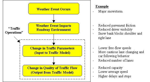
Figure 2. Relationship Between Weather Events and Traffic Operations.
Figure 2 shows the general relationship between weather events and the resulting impact on traffic operations. This relationship is similar to that shown by Pisano and Goodwin, with the exception that the definition of "traffic operations" has been divided into two subparts: traffic parameters (or characteristics) and quality of traffic flow.(3) Traffic parameters are quantitative values that typically are used as inputs to a traffic analysis model. These parameters account for how drivers and their vehicles interact and respond to the roadway network, including the response to other vehicles, traffic control devices, roadway geometry, weather, and other environmental conditions. The quality of traffic flow is the output from a traffic analysis model and is calculated using MOEs. MOEs measure the overall performance of the transportation system, which is directly related to how well drivers and their vehicles respond to the surrounding factors (traffic parameters). Common MOEs include average speed, average density, average delay per vehicle, and number of stops.
This distinction between the input and output in traffic operations is important because traffic analysts need to know, for a certain weather event, which traffic parameters to change and how much to change them when inputting these parameters into a traffic analysis model. These changes will produce a new quality of traffic flow reflecting the impacts of the weather event.
Weather events are any meteorological occurrence that causes weather conditions to degrade from the "ideal" weather condition. The ideal weather condition is defined as having the following conditions:
No precipitation.
Dry roadway.
Good visibility (greater than 0.4 km).
Winds less than 16 km/h.(4)
Weather events can change quickly in severity and in coverage area. These changes over time and space present a challenge in modeling weather events in a traffic analysis model. The ranges of possible weather events that are addressed in this study include rain, snow, sleet, hail, flooding, fog, ice, sun glare, lightning, dust, wind, and extreme temperatures.
Weather events cause a change in the "roadway environment," a term used by Pisano and Goodwin, meaning a physical change in the roadway or roadway devices, or a change on the immediate environment surrounding the roadway (including the driver), and vehicle changes.(3) Each weather event impacts the roadway environment differently.Table 1 shows the connection between weather events and the roadway environment. As shown in the table, various weather events, such as fog, dust, rain, snow, sleet, hail, and sun glare, can reduce driver visibility.
Table 1. Impacts of Weather Events on Roadway Environment.
| Impact on Roadway Environment |
|
|---|---|
| Fog, dust, rain, snow, sleet, hail, sun glare |
Reduced driver visibility |
| Ice, rain, snow, sleet, hail, flooding |
Blocked lanes or covered signs and pavement markings Reduced pavement friction (note that reducing pavement friction leads to a reduction in vehicle maneuverability) |
| Wind |
Reduced vehicle maneuverability and stability |
Extreme temperatures, lightning, wind |
Failed traffic control devices and communications |
As the roadway environment changes, resulting changes in traffic parameters will occur. For example, a reduction in driver visibility will logically cause most drivers to drive more cautiously, to some degree. This changed driver behavior is reflected in simulation traffic parameters, such as lower free-flow speeds and more cautious lane changing and car following parameters. Traffic parameters represent values that a traffic engineer can control in a simulation model. The ability to modify these parameters in a simulation model provides the means for simulating the impacts of adverse weather conditions. The challenge with microscopic simulation models like CORSIM is that they require many more input traffic parameters than a macroscopic HCM-style model due to the complex modeling of driver behavior on an individual vehicle basis.
Before tracing which traffic parameters are impacted by a change in the roadway environment, it is important to understand the full range of parameters available in a microscopic simulation model. Table 2 displays a generic list of possible traffic parameters in a microscopic simulation model. The parameters are considered generic because they are not specific to any one model, and the majority of them are included in most simulation models currently available. However, each model uses slightly different terminology to define these parameters. Therefore, the parameters listed in table 2 may only be a subset of the actual simulation models parameters. For example, there are more than 20 parameters in CORSIM that are used to model lane changing behavior.
Tracing which traffic parameters are likely affected by weather events (through a change in the roadway environment) was performed based on a review of table 2, the literature review (section 3), and engineering judgment. The results of this analysis are presented in section 4 after the literature review section.
Category |
Parameters |
|---|---|
| Road geometry |
Pavement condition (wet, dry, etc.) |
| Traffic control and management |
Traffic signal |
| Driver behavior |
Car following |
| Events/scenarios |
Incidents/blockages (severity, duration) |
| Vehicle performance |
Vehicle type distribution (% trucks, buses,
etc.) |
Simulation run control |
Length of simulation run |
Traffic demand |
Vehicle demand (including changes over time), expressed as: |
| Multimodal operations |
Transit operations (routes, stops, headways, dwell times, etc.) |
Past research on the simulation of traffic operations under adverse weather conditions can be organized into two main groups: those focusing on the link between weather events and traffic parameters (i.e., heavy rain reduces free-flow speeds by 30 percent), and those focusing on the link between weather events and the quality of traffic flow (i.e., heavy rain increases delays by 40 percent). This review focuses on the former, because knowing the impact of weather events on traffic parameters is the key to using microsimulation to model weather events.
Very little research focusing on the roadway environment impacts shown in table 1 were found. This lack of information probably is due to the difficulty in understanding why motorists respond to a weather event (i.e., is a reduction in free-flow speed really due to a reduction in pavement friction or reduction in visibility?) The literature review yielded information on the impacts of weather events on the following traffic parameters: free-flow speed, startup lost time, saturation headway, and traffic demand.
A number of studies have shown that adverse weather events reduce the mean free-flow speed, which is defined as the desired speed of drivers in low volume conditions and in the absence of traffic control devices.(2) The amount of reduction in free-flow speed is directly related to the severity of the weather event. Kyte et al. studied the free-flow speed on a rural freeway during wet and snow-covered pavement, high wind (greater than 24 km/h), and low visibility conditions (less than 0.28 km).(4) They found the free-flow speed reduced by approximately:
Based on a study of two-lane rural highways, Lamm, Choueiri, and Mailaender found that drivers do not adjust their speeds very much under light rain or wet pavement, but they do reduce speeds when visibility becomes obstructed, such as during a heavy rain.(6)
On a sample of freeways in Canada, Ibrahim, and Hall also found that free-flow speed is noticeably decreased during heavy rain and snow; heavy snow (up to 50 km/h reduction) has a much greater effect than heavy rain (up to 10 km/h reduction).(7)
Perrin, Martin, and Hansen measured free-flow speed reductions at two signalized intersections on an arterial in Salt Lake City, UT of:(8)
10 percent on wet pavement.
25 percent on wet and slushy pavement.
30 percent on pavement with slushy wheel paths.
Other studies have shown a reduction in average speed on arterials.(9,10) Average speed, a typical MOE used by traffic engineers, is a different value than free-flow speed; average speed accounts for the effects of signal timing and other effects related to the interaction with other vehicles.
Startup lost time is defined as the additional time consumed by the first few vehicles in a queue at a signalized intersection beyond the saturation headway.(2) This additional time is due to the time to react to the start of the green phase and for the vehicle to accelerate from a stopped position. Under ideal conditions, the HCM recommends using 2.0 seconds for startup lost time.
Maki measured an increase in startup lost time of 50 percent, from 2.0 seconds during normal conditions to 3.0 seconds under adverse weather conditions, which was defined as being a storm with accumulation of 7.6 centimeters (cm) or more of snow, on a signalized expressway in the Minneapolis/St. Paul, MN area.(9)
Perrin, Martin, and Hansen measured a startup lost time increase of approximately 25 percent, from 2.0 to 2.5 seconds, under severe snow-related conditions.(8) However, only a small difference, from 2.0 to 2.1 seconds, was measured during rain-related conditions.
Saturation headway, or discharge headway, is defined as the average headway between vehicles occurring after the fourth vehicle in a signalized intersection queue and continuing until the last vehicle in the initial queue clears the intersection.(2) Saturation headway (expressed in units of seconds/vehicle (s/veh)) is the inverse of saturation flow rate (veh/s or veh/h). For example, a 10 percent increase in saturation headway equates to a 10 percent decrease in saturation flow rate. The HCM recommends an ideal discharge headway of 1.9 seconds (equates to a saturation flow rate of 1900 passenger cars/h/lane). This value then is reduced based on adjustments for lane width, heavy vehicles, grade, adjacent parking, bus blockage, area type, lane utilization, right and left turns, pedestrians, and bicyclists.
Perrin, Martin, and Hansen measured an average reduction in saturation flow rate of between 6 and 20 percent, increasing with weather severity (snow packed on the street surface being the highest severity).(8)
Maki found a saturation flow rate reduction of approximately 10 percent, from 1800 to 1600 veh/h/lane under adverse weather conditions as defined above.(9)
Botha and Kruse measured the effect of residual ice and snow on a signalized arterial in Fairbanks, AK. Saturation flow rates were found to be approximately 20 percent lower than the ideal HCM-recommended conditions.(11)
Maki measured a reduction in traffic volumes of 15 to 30 percent during adverse weather conditions when compared to ideal weather conditions.(9) The reduction in traffic volumes was attributed to various reasons, including shifting work arrivals and departures, and avoidance of discretionary trips. Traffic demand changes depend strongly on the severity of the weather conditions and the driver's comfort in adverse weather conditions. For example, drivers in Chicago, IL will react differently to a snowstorm than will drivers in Miami, FL.
The literature review documented a number of traffic parameters that were found to be impacted by weather events. However, there are numerous other microsimulation parameters that have not been measured empirically to behave differently during adverse weather. It is important to identify these parameters and include them in the sensitivity study.
Tables 3 through 7 show the traffic simulation parameters that likely are impacted by weather events (through a change in the roadway environment). The selection of these parameters was based on the range of simulation parameters identified in table 1, the literature review, and the use of engineering judgment based on the concept that driver behavior becomes more conservative during adverse weather conditions. Unfortunately, there is currently no empirical research supporting this concept. Therefore, the table only lists the range of potential, not proven, simulation parameters that may be used to model adverse weather conditions in a simulation model. These simulation parameters may be used as a guide for traffic analysts when considering which parameters to adjust when modeling adverse weather.
The remainder of this section discusses how parameters in each major category (road geometry, traffic control and management, vehicle performance, traffic demand, and driver behavior) may be impacted by weather events.
Table 3 displays road geometry parameters likely impacted by weather events though a change in the roadway environment. If available in a simulation model, the pavement condition parameter should be modified during a weather event, causing a reduction in pavement friction. The traffic analyst should be aware, however, how the pavement condition parameter affects other parameters. For example, changing the pavement condition parameter in FRESIM (the freeway model within CORSIM) causes an automatic reduction in free-flow speed for a link in a horizontal curve. Also, a weather event causing a lane or shoulder blockage would alter the number and width of available lanes, length of tapers associated with lane adds and drops, and shoulder width.
Table 3. Road Geometry Traffic Parameters Impactedby Weather Events.
| Generic Traffic Simulation Parameter |
Weather Events |
|||||
|---|---|---|---|---|---|---|
| Fog, Dust, Rain, Snow, Sleet, Hail, Sun Glare |
Ice, Rain, Snow, Sleet, Hail, Flooding |
Wind, Ice, Rain, Snow, Sleet, Hail, Flooding |
Ice, Rain, Snow, Sleet, Hail, Flooding |
Extreme Temperatures, Lightning, Wind |
||
| Roadway Environment Impact |
||||||
Reduced Visibility |
Reduced Pavement Friction |
Reduced Vehicle Maneuverability/Stability |
Blocked Lanes/ Covered Signs and Pavement Markings |
Failed Traffic Control Devices and Communications |
||
| Pavement condition |
X |
|||||
| Number of lanes |
X |
|||||
| Lane width |
X |
|||||
| Lane taper length |
X |
|||||
| Shoulder width |
X |
|||||
Table 4 displays traffic control and management parameters likely impacted by weather events though a change in the roadway environment. A reduction in visibility would make it difficult for drivers to see traffic signals or signs. Thus, the parameters related to sight or reaction distance to the traffic signals and signs would need to be altered. Also, a weather event that caused a sign blockage would require altering the parameters related to the visibility of, and compliance with, traffic signs. Finally, a weather event causing a power failure and loss of communications between traffic devices or to a traffic management center would require altering the traffic signal settings (i.e., change to emergency flash operation), or removing the functionality of detector devices, including those used at traffic signals, ramp meters, or systemwide surveillance.
Table 4. Traffic Control and Management Parameters Impacted by Weather Events.
| Generic Traffic Simulation Parameter |
Weather Events |
||||
|---|---|---|---|---|---|
| Fog, Dust, Rain, Snow, Sleet, Hail, Sun Glare |
Ice, Rain, Snow, Sleet, Hail, Flooding |
Wind, Ice, Rain, Snow, Sleet, Hail, Flooding |
Ice, Rain, Snow, Sleet, Hail, Flooding |
Extreme Temperatures, Lightning, Wind |
|
| Roadway Environment Impact |
|||||
| Reduced Visibility |
Reduced Pavement Friction |
Reduced Vehicle Maneuverability/Stability |
Blocked Lanes/ Covered Signs and Pavement Markings |
Failed Traffic Control Devices and Communications |
|
| Traffic signal |
X |
X |
|||
| Ramp meter |
X |
X |
|||
| Regulatory signs |
X |
X |
|||
| Warning signs |
X |
X |
|||
| Traveler information signs |
X |
X |
X |
||
| Surveillance detectors |
X |
||||
| On-street parking |
X |
||||
Table 5 displays vehicle performance parameters likely impacted by weather events though a change in the roadway environment. A reduction in pavement friction could affect the acceleration and deceleration capabilities of vehicles. These parameters relate to the performance of the vehicle only, and not necessarily the behavior of the drivers. The acceleration and deceleration capability of vehicles typically are used in the car following and lane changing logic of a simulation model; therefore, changing these parameters likely will alter the way vehicles follow each other and change lanes in a model.
Table 5. Vehicle Performance Traffic Parameters Impacted by Weather Events.
| Generic Traffic Simulation Parameter |
Weather Events |
||||
|---|---|---|---|---|---|
| Fog, Dust, Rain, Snow, Sleet, Hail, Sun Glare |
Ice, Rain, Snow, Sleet, Hail, Flooding |
Wind, Ice, Rain, Snow, Sleet, Hail, Flooding |
Ice, Rain, Snow, Sleet, Hail, Flooding |
Extreme Temperatures, Lightning, Wind |
|
| Roadway Environment Impact |
|||||
| Reduced Visibility |
Reduced Pavement Friction |
Reduced Vehicle Maneuverability/Stability |
Blocked Lanes/ Covered Signs and Pavement Markings |
Failed Traffic Control Devices and Communications |
|
| Acceleration/ deceleration capability |
X |
X |
|||
| Turning radius |
X |
X |
|||
Table 6 displays traffic demand parameters likely impacted by weather events through a change in the roadway environment. Any weather event causing one or more major roadway environment impacts could cause a change in vehicle demand and route choice. For example, a major snowstorm over an entire city could cause vehicle demand to be reduced on all links, whereas an isolated storm affecting only a small number of roads could result in no change in overall traffic demand but different route choices, because drivers would avoid the impacted roads. Many simulation models allow the input of traffic demands as origin-destination pairs with a traffic assignment procedure (which determines the preferred route for motorists in traveling between their origin and destination) built into the model. For these models, changing the appropriate parameters to reflect the conditions of the snowstorm on the isolated roads would allow the traffic assignment algorithm to predict automatically the change in route choice associated with the snowstorm.
Table 6. Traffic Demand Traffic Parameters Impacted by Weather Events.
| Generic Traffic Simulation Parameter |
Weather Events |
||||
|---|---|---|---|---|---|
| Fog, Dust, Rain, Snow, Sleet, Hail, Sun Glare |
Ice, Rain, Snow, Sleet, Hail, Flooding |
Wind, Ice, Rain, Snow, Sleet, Hail, Flooding |
Ice, Rain, Snow, Sleet, Hail, Flooding |
Extreme Temperatures, Lightning, Wind |
|
| Roadway Environment Impact |
|||||
| Reduced Visibility |
Reduced Pavement Friction |
Reduced Vehicle Maneuverability/Stability |
Blocked Lanes/ Covered Signs and Pavement Markings |
Failed Traffic Control Devices and Communications |
|
| Vehicle demand |
X |
X |
X |
X |
X |
| Route choice |
X |
X |
X |
X |
X |
Table 7 displays driver behavior parameters likely impacted by weather events though a change in the roadway environment. Many driver behavior parameters are impacted by weather events causing visibility, pavement friction, or vehicle maneuverability reductions. Car following and lane changing behavior likely will be more cautious during weather events, with the degree of caution dependent on the severity of the weather event. Free-flow speed, startup lost time, and discharge headway all have been documented to degrade during weather events. In addition, intersection-related parameters such as gap acceptance, turning speed, and responses to the yellow interval likely are impacted by weather events.
Table 7. Driver Behavior Traffic Parameters Impacted by Weather Events.
| Generic Traffic Simulation Parameter |
Weather Events |
||||
|---|---|---|---|---|---|
| Fog, Dust, Rain, Snow, Sleet, Hail, Sun Glare |
Ice, Rain, Snow, Sleet, Hail, Flooding |
Wind, Ice, Rain, Snow, Sleet, Hail, Flooding |
Ice, Rain, Snow, Sleet, Hail, Flooding |
Extreme Temperatures, Lightning, Wind |
|
| Roadway Environment Impact |
|||||
| Reduced Visibility |
Reduced Pavement Friction |
Reduced Vehicle Maneuverability/Stability |
Blocked Lanes/ Covered Signs and Pavement Markings |
Failed Traffic Control Devices and Communications |
|
| Car following |
X |
X |
X |
X |
|
| Lane changing |
X |
X |
X |
X |
|
| Free-flow speed |
X |
X |
X |
X |
|
| Discharge headway |
X |
X |
X |
X |
|
| Startup lost time |
X |
X |
X |
X |
|
| Intersection gap acceptance |
X |
X |
X |
X |
|
| Turning speed |
X |
X |
X |
X |
|
| Response to yellow interval |
X |
X |
X |
X |
|
[1] HCM methodologies do not specifically address the impacts of weather events on highway capacity and quality of service: however, the parameters in the HCM could be user-adjusted to reflect the impacts of weather events.

