U.S. Department of Transportation
Federal Highway Administration
1200 New Jersey Avenue, SE
Washington, DC 20590
202-366-4000
Federal Highway Administration Research and Technology
Coordinating, Developing, and Delivering Highway Transportation Innovations
 |
| This report is an archived publication and may contain dated technical, contact, and link information |
|
Publication Number: FHWA-HRT-06-095
Date: May 2006 |
This chapter provides an overview of the categorical technologies needed to share information in a timely manner and coordinate freeway and arterial operations. In no way is this chapter a definitive thesis on the issue of ITS technologies. At best it is a sampling of what is a needed and dynamic aspect of traffic control for corridor management. In many respects, coordinating traffic operations on a corridor is the embodiment of the ITS philosophy, which is "to enhance existing transportation systems operations through the application of new and emerging methods and technologies."(26) Upon completion of this chapter, the reader should have a basic understanding of the electronic infrastructure and system interfaces that are available to support the proactive management of travel within a freeway corridor. In essence, the reader will learn about the technology that supports the goals of CFA operations. But technology must not only support better operations, it must also be cost effective. Technology assessment should therefore drive the needs of the application(s).
CFA is about process and technology. The process for coordinating freeway and arterial operations described in chapters 3 and 4, set the stage for coordinated operations such that regional stakeholders might optimize vehicular throughput associated with incidents, work zones, special events, and day-to-day operations. This chapter describes some of the software and hardware tools available to permit CFA operations. The concepts of ITS promote new methods and devices, making technology more transitional than the process. Therefore it is hoped that the reader will look beyond the methods and devices currently used in their particular region. As discussed in section 5.4.1.1, advanced sensor technology integrated with CCTV surveillance and new approaches to their use offer considerable advantages in timely recognition of traffic incidents and the variable nature of traffic volumes.
This document places considerable emphasis upon interagency cooperation and communication and thinking in terms of region and corridor instead of agency or municipality. One of the essential outputs of a cooperative working agreement is sharing information. While the purpose of this chapter is to present technology enhancements for sharing information, consider one relatively low-tech device: the telephone, provides a very high level of information sharing. With only a telephone, agencies can take the first step toward
|
Sharing information must lead to effective cooperation in the context of corridorwide thinking and action. The corridor must be treated as a dynamic, interconnected system. |
corridor management operations if the proper planning, as described throughout this document, has taken place. But sharing information is not enough. Sharing information must lead to effective cooperation in the context of corridorwide thinking and action. The corridor must be treated as a dynamic, interconnected system.
The direct communication between different agencies and municipalities sharing historic traffic count information, growth trends, accident data, upcoming work zone repairs, etc., is the "ice-breaker" for more sophisticated data sharing. Human interaction, trust, and mutual benefit are the underpinning of even the most sophisticated electronic data-sharing network.
On both freeways and arterials, means of collecting data to facilitate coordinated operations may already be in place. Detection and surveillance, for example, are often part of many freeway and arterial control systems. While such systems are intended to serve the agency and the facility upon which they were installed, they can, with little modification, be interconnected for purposes of information sharing. The objective of using technology in a CFA environment is to gain real-time information that can be acted upon so that incidents and activities in the dynamic traffic stream are altered or corrected before they become major problems.
Figure 19 shows the three principal parts of the logical system that drives successful coordination:
Coordination is about sharing data or information that is useful to others, as demonstrated in figure 19. This is important because in many States, multiple agencies operate freeways and arterials. State DOTs typically own and maintain the freeway system and some major arterials, and city or county agencies are responsible for most arterials and some secondary arterial roads. Through coordinated actions, the operation of these separate systems can be made more useful from a user perspective. To achieve this result, information needs to be shared effectively. Data collection and sharing can be accomplished through a variety of ITS technologies.
Travelers can get information on arterial and freeway traffic conditions through a variety of means, many of which they already rely upon. DMSs, HAR, and radio traffic reports can all be used to advise drivers of conditions as they travel. Pretrip information can be made available via the Internet or by phone. Automated systems can also be tied to in-vehicle navigation units to provide dynamic route guidance.
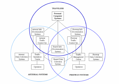
Figure 19. Chart. Traveler interface with technology systems.
Technology plays a role in any CFA plan. The level of ITS deployment on a region's freeways and arterials is not the main driver in developing CFA solutions. What is more likely to drive the CFA process is whether the solution is dependent upon the existence of an already-deployed technology or is only enhanced by that particular technology. As an example, route diversion strategies based upon daily peak period traffic flows can be developed with historical traffic data alone. Such a strategy could be significantly enhanced by real-time data from an array of sensors and surveillance cameras but the strategy deployment is not wholly dependant upon the technology. Conversely, incident management strategies that require immediate identification and verification of incidents at critical links in the roadway system, e.g., bridges, tunnels, and high security locations, will require technologies to be deployed for the solution to work. ITS elements that may support CFA operations can be grouped as follows:
The following sections describe these infrastructure elements and their role in CFA deployment. The appendix details a recommended procedure for the actual performance of such an inventory.
The primary source of traffic flow information is the traffic sensor; however, several additional data collection systems have been developed primarily for ITS applications. These data collection systems can be used to gather traffic information on both freeways and arterials. There are several different types of data collection systems of varying age and capability already in place in any urban (and increasingly suburban and rural) setting. Examples of traffic data collection systems include the following five areas:
Traffic sensor (detector) is an all-encompassing term for the generic device used by the traffic engineering community to measure traffic flow. Traffic sensors play a primary role in CFA data sharing and in CFA-shared operations. As previously noted, a variety of technologies can do much the same thing: namely, detect traffic. Some technologies require pavement intrusion, and some are mounted overhead. The real difference in sensors lies in their capabilities. There are only two kinds of traffic sensors: the static or, more commonly, point measurement, and the dynamic sensor, measuring flow characteristics. This important distinction is misunderstood or ignored by many even in the transportation community. Sensors of one type or another are essential to virtually every CFA solution involving traffic monitoring and control on freeways and arterials.
Some examples of existing detector technology commonly found in freeway and arterial traffic control applications include:
Traffic sensors can be as simple as point measurement detectors (loops) or as sophisticated as dynamic vehicle tracking sensors that are capable of measuring multiple traffic parameters of an individual vehicle or a collective group (vehicle queue) within a traffic stream. Depending on the detector type deployed, the detector can potentially measure the following traffic parameters:
FHWA has been promoting the development of more advanced traffic sensors since the mid-1970s. By the mid-1980s, digital image sensors based on CCTV that could track individual and collective groups of vehicles in a traffic stream were being developed.
The availability of cheap, robust CCTV equipment has allowed sensors based on this technology to be cost competitive with other sensor technologies. The sensor itself is simply software and therefore can be located anywhere the electronic CCTV image is available, such as a TMC. More information on traffic sensors is available in the FHWA Traffic Detector Handbook.(27)
For many years motorist call-in boxes have been placed along freeways primarily to aid stranded motorists. Over the past decade newer and more reliable technologies have assumed the role for most of the call-in boxes. Often the technology replacing the call-in box does not have as its primary mission "helping stranded motorists." Cell phones are an obvious example of a technology that assists a stranded motorist in securing assistance. Such new technologies often bring additional and better ways for transportation officials to monitor and control traffic. As the population of cell phones with motorists in the traffic has increased, so has the reliability of anonymous signal tracking to monitor general route traffic flow parameters. Live calls from motorist in the vicinity of an incident or reporting traffic congestion have increasingly proven reliable tools as the number of cell users increases.
There are a variety of reasons why it is important to determine the whereabouts of a particular vehicle. One of the obvious needs is tracking explosives, toxic chemicals, and hazardous nuclear waste to insure public safety. Specific duty-cycle-vehicle fleets such as transit buses, emergency vehicles, and delivery vehicles operations also benefit from knowing the specific location of fleet vehicles. At present, several technologies permit such tracking; e.g., global position systems (GPS) and radio transponders. The ease, cost effectiveness, and multiple uses of GPS suggest that this technology will continue to become pervasive in many and varied fleet monitoring operations. Using the tracking points of fleet vehicles immersed in the traffic stream permits real-time monitoring of traffic system conditions. While this would not be the only means of monitoring a CFA solution, it serves as a powerful overview of the systemic situation.
Today, surveillance cameras and CCTV systems are reliable and cost effective. They provide transportation systems operators with a live visual image of traffic conditions and to some extent weather conditions. Surveillance cameras have been used in security systems for several decades and increasingly, in the past decade, for remote infrastructure monitoring. The digital image of surveillance cameras serves as the input for most advanced dynamic sensors. Therefore, a single technology deployed along the roadside can serve as a visual monitor of traffic conditions and the digital source to measure the dynamics of the traffic stream. Such a dual capability can be an essential component in several CFA solutions.
Weather conditions can be a major factor in the performance of the traffic stream. In some situations however, weather is a critical component of safe traffic stream performance. A variety of weather reporting stations have been deployed for many years in locations where changing conditions are a significant hazard to public safety. One of the earliest systems was installed along the New Jersey Turnpike to detect the presence of rapid fog formation. Using variable message signs and variable speed limit signs motorists are informed and directed when conditions warranted. The concepts of RWIS has expanded as a result of ITS awareness, and deployments now include a variety of sensors and pavement monitoring systems permitting system operators to gauge the need for roadway salting and snow plowing ahead of actual icing conditions on the pavement surface. The AZTech system mentioned earlier in this document employs an RWIS to monitor for wind conditions and dust storms. A variety of CFA strategies might be predicated on weather-related conditions.
Some of the data collected by RWIS may include the following road-weather related information:
Transportation department dispatchers can use this information, for example, to anticipate the occurrence of icing on roadways and bridges and in turn, dispatch road crews to place de-icing chemicals.
Examples of traffic control systems commonly used on freeways include:
Ramp metering systems are typically controlled locally with ramp detector data inputs and a central system connection for manual overrides and turning the system on or off. More robust systems employ algorithms with freeway mainline and arterial detector data inputs to optimize traffic on all systems and achieve appropriate impacts on the arterials and freeways.
Freeway lane controllers typically use a green down arrow above a lane to indicate the lane is open and a red X above a lane to indicate a closed lane. Lane controllers can be used on freeways to indicate that a lane is closed ahead, often due to construction or an incident. Freeways that allow vehicles to travel on the shoulder during peak periods often use lane controllers to indicate that the shoulder is clear for use, which enables operators to immediately close the lane with a red X if the shoulder becomes blocked.
Lane controllers are also used on reversible lane freeway systems to guide motorists. Reversible lane freeway systems (i.e., express lanes) are often located in the middle of a freeway with limited entrance and egress points, and they are sometimes dedicated to HOV access only. Reversible lanes are often used on bridges as well to manage directional traffic flow. Reversible lane systems on freeways are most often controlled manually for safety purposes to ensure that the facility is free of vehicles prior to reversing the lane(s) direction. Most agencies follow a standard peak hour schedule for reversing the travel lanes, but implement schedule changes to accommodate traffic from special events, construction, and even major incidents.
Examples of traffic control systems commonly used on arterials include:
Although traffic signal control systems are mostly or fully automated, their means of control vary from time-of-day control to actuated control to traffic adaptive control systems. Connection to a central control facility enables operator awareness of traffic conditions. It also enables traffic management while allowing the operator to interrupt system control and manually override traffic signal systems to improve operations if it becomes necessary to respond to the effects of special events traffic, construction, and incidents.
Lane controllers and reversible lane systems on arterials are used and operated in a similar fashion to freeway reversible lane operations. However, arterials typically do not have separated facilities for reversible lanes. This enables use of automation to control the systems because motorists can merge into adjacent nonreversible lanes when the lane controllers switch lane operations.
All pretrip information dissemination systems require the general public to perform an action to obtain traveler information. Pretrip information dissemination systems include:
The only en route information dissemination systems which do not require motorist action to obtain traffic information are DMSs and static signs with flashing beacons. DMSs allow operators to disseminate any information to the traveling public, although it is limited by the amount of time drivers have to read the information. The static sign with flashing beacon implementation is limited to only providing one static message to motorists of a condition, such as "Traffic Congestion Ahead When Flashing."
En route systems may include:
All of the pretrip and en route information dissemination systems can be used to inform motorists of travel conditions on both freeways and arterials.
ITS infrastructures rely heavily on communications networks. Hard wire and/or wireless networks are necessary for all CFA operations applications; they typically employ a transmitter at the device end and receiver at a communications hub or control center to enable communications between and among field and control center systems.
The final ITS infrastructure element is communications systems, which include systems that enable communications between centers. In fully integrated systems, the communication system might make use of control center software and communications networks to:
Distributed control centers without system integration may make use of common communications means, such as telephones and the Internet, for transmitting information between stakeholders. Communications systems enable CFA operations agencies and their systems.
Traffic data analysis systems most often reside on central system software at a traffic control center, but they can also reside locally in a field cabinet with software residing on a processor or controller. Data analysis systems for freeways are considerably different from those for arterials. Although the concepts may be the same, the data analysis systems are different because of the differences in arterial and freeway operations and traffic patterns.
Data analysis systems can be categorized as one of the following:
Data analysis systems typically become more robust as the number of data elements analyzed increases, whether the increase is in the type of data elements or the number of data elements.
Examples of data analysis systems include:
The National ITS Architecture provides a common framework for planning, defining, and integrating ITS. It reflects the contributions of a broad cross-section of the ITS community (transportation practitioners, systems engineers, system developers, technology specialists, consultants, etc.). The architecture defines:
Each State and MPO is required to develop its own ITS architecture modeled on the National ITS Architecture in order to participate fully and effectively in the program and be eligible for Federal funding. More information on developing an ITS architecture can be found at http://www.ops.fhwa.dot.gov/its_arch_imp/index.htm.
From its inception in 1996 to the present, the ITS Standards Program am has had a primary focus on the development of open, nonproprietary communication standards and protocols that facilitate the integration of ITS devices and networks. To accomplish this challenging mission, the ITS Standards Program collaborates with seven national standard development organizations to coordinate and accelerate the development of ITS standards. Collaborating allows the ITS Standards Program to tap into existing standards development processes, thus eliminating the need to create new procedures. Collaborating also facilitates the engagement of industry experts who help inform the technical discussion of volunteer committees, of consultants who capture the working group's intent when writing the standard, and of public sector transportation professionals who bring an invaluable perspective on real-world ITS implementations.
The ITS standards are used at the intersection between both similar and different types of ITS devices and components. The standards define how the components exchange information and work together to deliver the user services desired by State and local agencies from their defined systems.
The evaluation found that standards allow the "interconnections" to be open to all of the elements — open to any device, vehicle, center, or traveler to connect to and receive or transmit data to any other element in the system. Standards also define how the data is formatted so they are unambiguously recognized by all the other elements in the system. More information about ITS standards can be found at http://www.standards.its.dot.gov/default.asp.
CFA operations require some element of each categorical technology described in this chapter. In the most basic systems, data input can be as simple as a police officer's observation of a traffic blocking incident or as sophisticated and dynamic as an array of roadway sensors monitoring all traffic parameters and immediately noting any anomaly to a TMC. As well, the most basic way to get a message to the motorist is through simple posted signs. Enhancing simple, basic signs are technologies such as HAR, DMS, and GPS navigation systems. In developing and deploying technology elements associated with CFA, several main points should be considered:
The key element in the CFA process is information sharing. The modifier is timeliness, or how quickly the information needed to make a decision. The need for speed will dictate how much and what type of technology is necessary to optimize traffic flow on the corridor in question. The next chapter provides examples of CFA operations.
FHWA-HRT-06-095

