U.S. Department of Transportation
Federal Highway Administration
1200 New Jersey Avenue, SE
Washington, DC 20590
202-366-4000
Federal Highway Administration Research and Technology
Coordinating, Developing, and Delivering Highway Transportation Innovations
 |
| This report is an archived publication and may contain dated technical, contact, and link information |
|
Publication Number: FHWA-RD-98-133
Date: October 1998 |
|||
Accident Models for Two-Lane Rural Roads: Segment and Intersections3. Data CollectionThe Populations and Sample Selection The States for which data were obtained are Minnesota and Washington. Both of these States are included in the Highway Safety Information System (HSIS), and both States have relatively well-maintained data bases. In addition, data for recent years (1985 through 1994 for Minnesota and 1993 through 1995 for Washington) were available, or became available in the course of the study. For Washington a shortcoming was the unavailability of a separate intersection file. The populations from which the samples were drawn were rural segments of two-lane roads and rural three- and four-legged intersections of two-lane roads stop-controlled on the minor road. The roads had to be present in State and HSIS databases, and thus the segment road or major road was always a State highway. Roads with unusually low traffic were not included, and other reasonable constraints were imposed. Samples were picked from the population in part randomly and in part systematically. Since the purpose of this study was not to summarize the population of each State, but rather to obtain insight into the effects of different variables, observations were selected with some view to achieving variety in traffic volumes, roadway width, and terrain. Minnesota Segments The sample of Minnesota segments was prepared as follows: i) HSIS files of homogeneous segments of State roads for two time periods, 1985-1987 and 1988-1989, were obtained and the constraints below were imposed.
ii) The resulting population consisted of 3,308 segments. Some statistics, derived from HSIS data, on this population are presented in Appendix 1. Median values of ADT, segment length, surface width, and shoulder width were obtained for the population and used to classify segments by high versus low ADT, high versus low segment length, high versus low surface width, and high versus low shoulder width. The population was then divided into 16 bins on the basis of whether each of the four variables was high or low. The resulting bins varied in size from 13 segments to 679 segments. Thirteen segments were randomly selected from each bin, along with a hundred other segments randomly selected from the remaining population as a whole, and these formed a pilot study sample of 308 segments. iii) The pilot study sample was eventually enlarged by the addition of 416 more segments so that all members of the six smallest bins were included in the sample. The sizes of these six bins ranged from 13 segments to 45 segments. The selection method for the final sample was equivalent to exhaustion of the first six bins, a random choice of 45 segments from each of the remaining bins, and a random choice of a hundred additional segments from the remaining bins without regard to bin membership. The resulting sample consisted of 724 segments. iv) For each of these segments an attempt was made to obtain photolog data (signage, Roadside Hazard Rating, driveways, intersections, speed limits) at FHWA and in Minnesota and to extract vertical and horizontal alignments along the segments as they were in the years 1985-1989 from construction plans in Minnesota. After much investigation and double-checking, relatively complete data could be acquired for 619 segments. These constituted the final sample. The remaining segments were removed because photologs or construction plans were unavailable or were seriously incomplete, because significant regrading or realignment had been done in the time period 1985-1989, or in a few cases because photologs revealed that the segments were not two-lane roads. One segment was removed because the ADT was 22,710 vehicles per day, substantially higher than that of all others roads in the study. Minnesota Intersections The samples of Minnesota intersections were prepared as follows: i) HSIS files of intersections with main line a State road for two time periods, 1985-1987 and 1988-1989, were obtained and the constraints below were imposed.
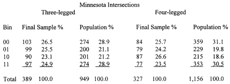
ii) The resulting populations consisted of 949 three-legged intersections and 1,156 four-legged intersections. See Appendix 1 for statistics concerning these two populations. Median values of main line ADT and minor road ADT were obtained for each population and used to classify intersections by high versus low major road ADT, and high versus low minor road ADT. Each population was then divided into four bins numbered 00 to 11, based on whether each of the two variables was high or low. 1 means high, 0 low, and the first number refers to major road ADT, the second to minor road ADT. The resulting bins had the sizes shown below.
iii) Initially pilot study samples of 25 intersections were chosen randomly from within each of the eight bins. Examination of photologs showed that intersections in three of the bins failed to satisfy the constraints in disproportionately large numbers. So 10, 5, and 7 extra intersections were chosen randomly from the bins 3-legged 10, 3-legged 11, and 4-legged 10, respectively. Thereafter in the course of ensuing months an additional 100, then 160, and then 200 intersections were chosen randomly from the 3-legged bins in equal numbers; while an additional 100, and then 160 were chosen likewise from the 4-legged bins. The total sample of 3-legged intersections consisted of 100 + 10 + 5 + 100 + 160 + 200 = 575 intersections. The total sample of 4-legged intersections consisted of 100 + 7 + 100 + 160 = 367 intersections. iv) For each of these intersections an attempt was made to obtain photolog data (signage, Roadside Hazard Rating, driveways, turning lane/bypass lane data, speed limits) at FHWA and in Minnesota, and to extract vertical and horizontal alignments for curves any portion of which were within 764 feet of an intersection along the main line from construction plans in Minnesota. The information was for the intersections as they were in the years 1985-1989. Relatively complete data could be acquired for 389 three-legged intersections and 327 four-legged intersections. The remainder were eliminated because photologs showed that they did not satisfy the constraints, or plans were unavailable for them, or the intersections had significant construction during 1985-1989. Washington Segments The sample of Washington State segments was prepared as follows: i) HSIS files of homogeneous segments of State roads for the years 1993 and 1994 were obtained and the constraints below were imposed:
Unlike Minnesota, horizontal and vertical alignment data were available for Washington State in separate HSIS Horizontal and Vertical Curve files. ii) The resulting population consisted of 6,144 segments. Median values of ADT, segment length, surface width, and shoulder width were obtained for this population. The median segment length was 0.36 miles (considerably lower than Minnesota's median of 0.5695 miles). The segments were classified by high versus low ADT, high versus low segment length, high versus low surface width, and high versus low shoulder width, with the medians as the division points except for segment length for which 0.600 miles was used. The population was then divided into 16 bins on the basis of whether each of the four variables was high or low. The resulting bins varied in size from 87 segments to 913 segments. iii) 61 segments were picked randomly from each of the 16 bins, for a total of 976 segments. An additional 25 segments were picked for which the TERRAIN variable had the value "mountainous." iv) On the basis of videotape reviews, further examination of alignment variables, and an enlargement of the time frame to include the year 1995, the sample was reduced to a total of 712 segments. Some segments were eliminated because the videotapes showed that they did not meet the constraints (e.g., the environment was urban or the number of lanes had changed) or the alignment data contained anomalies such as a significant difference between the outgoing grade of one vertical curve and the incoming grade of the next. Others were omitted because in Washington State, unlike Minnesota, most segments begin and end with an intersection. After 250 feet were removed from one or both ends of segments in such cases, it was found that a significant number of segments no longer met the requirement that their length was greater than 0.1 miles. In addition, 1995 HSIS Washington State files became available at a relatively late stage of the study and the sample was further trimmed when the requirement was imposed that the segment also be present in the 1995 files with chief characteristics unchanged. Washington Intersections There are no HSIS intersection files for Washington State nor does the State maintain separate intersection files. Washington State videotapes were, however, accompanied by logs indicating the locations and names of all cross-streets along each State route. Since ADT data for county and local roads were not readily available, it was decided to note intersections of State roads found in the videotapes and satisfying the same constraints as the Minnesota data. This was not done for all Washington State videotapes, but only for ones being reviewed to extract data for the segment sample. A total of 431 intersections were reviewed by this method. The Washington State Department of Transportation provided a log of intersections for which it had ADT data on the cross-streets. The intersections in this log were intersections on State roads together with intersections in the Highway Performance Monitoring System. In addition, by inspecting HSIS road files, the Project Team was able to match major and minor State roads in some other cases to get ADT data. However, for some of the intersections no reliable estimate of cross-street ADT could be obtained. In addition, inspection of videotapes showed that some of the intersections failed to satisfy the intersection constraints imposed in Minnesota (e.g., they were not rural). When traffic, alignment, and roadway data were assembled, and incomplete observations removed, the resulting data sets, "opportunity" samples rather than a random samples, consisted of 181 three-legged intersections and 90 four-legged intersections.
|