U.S. Department of Transportation
Federal Highway Administration
1200 New Jersey Avenue, SE
Washington, DC 20590
202-366-4000
Federal Highway Administration Research and Technology
Coordinating, Developing, and Delivering Highway Transportation Innovations
 |
| This report is an archived publication and may contain dated technical, contact, and link information |
|
Publication Number: FHWA-HRT-05-113
Date: July 2006 |
Federal Highway Administration University Course on Bicycle and Pedestrian TransportationPDF Version (371 KB) PDF files can be viewed with the Acrobat® Reader®
LESSON 15: BICYCLE LANES
15.1 IntroductionThe 1999 AASHTO publication, Guide for the Development of Bicycle Facilities (hereafter referred to as the AASHTO Guide), defines a bicycle or bike lane as "a portion of a roadway which has been designated by striping, signing, and pavement markings for the preferential or exclusive use of bicyclists."(1) The public agency and community support for bike lanes as a reasonable accommodation of bicyclists has been growing in many American cities. Although some cities such as Davis, CA, have several decades of experience, many American cities are still developing innovative ways to design bike lanes into complex roadway and traffic environments. A number of best design practices have emerged and are included in the 1999 AASHTO MUTCD.(2) This lesson includes the design standards from AASHTO as well as additional design guidelines that other cities or States have developed. This lesson also summarizes other innovative bike lane designs and concepts (some are borrowed from Europe—see lesson 23) that are still being tested and evaluated. The major sections of this lesson are as follows:
This lesson on bicycle lanes has been derived from several sources, including the 1999 AASHTO Guide, the 1995 Oregon Bicycle and Pedestrian Plan, and the Philadelphia Bicycle Facility Design Guidelines.(1,3,4)
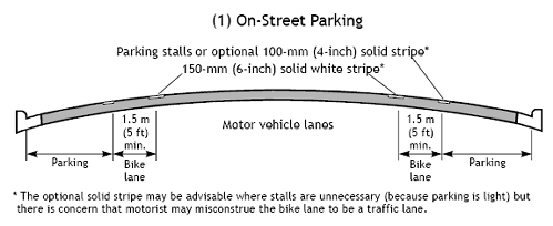
15.2 Width Standards and Cross-Section DesignBicycle lanes serve the needs of all types of cyclists in urban and suburban areas by providing them with a dedicated travel lane within the street space. The minimum width of a bike lane will vary based on the roadway cross section (see figure 15-1). For roadways with no curb and gutter, the minimum width of a bike lane should be 1.2 m (4 ft). If parking is permitted, the bike lane should be placed between the parking area and the travel lane, and have a minimum width of 1.5 m (5 ft). Where parking is permitted but a parking stripe or stalls are not utilized, the shared area should be a minimum of 3.3 m (11 ft) without a curb face and 3.5 m (12 ft) adjacent to a curb. Figure 15-1. Illustrations. Typical bike lane cross sections.
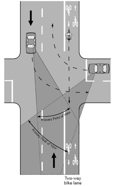
The recommended width of a bike lane is 1.5 m (5 ft) from the face of a curb or guardrail to the bike lane stripe. This 1.5-m (5-ft) width should be sufficient in cases where a 0.3–0.6 m (1–2 ft) gutter pan exists, given that a minimum of 0.9 m (3 ft) of ridable surface is provided and the longitudinal joint between the gutter pan and the pavement surface is smooth. If the joint is not smooth, 1.2 m (4 ft) of ridable surface should be provided. Since bicyclists usually tend to ride a distance of 0.8–1.0 m (32–40 in) from the curb face, it is very important that the pavement surface in this zone be smooth and free of structures. Drain inlets and utility covers that extend into this area cause bicyclists to swerve, resulting in a reduction of usable lane width. Where these structures exist and the surface cannot be made smooth, the bike lane width should be adjusted accordingly. Regular maintenance is critical for bike lanes (see lesson 16). Bicycle lanes are always located on both sides of the road on two-way streets. Since bicyclists must periodically merge with motor vehicle traffic, bike lanes should not be separated from other motor vehicle lanes by curbs, parking lanes, or other obstructions. Two-way bike lanes on one side of two-way streets create hazardous conditions for bicyclists and are not recommended. The problems associated with two-way bike lanes are discussed in more detail in section 15.8. On one-way streets, bicycle lanes should be installed on the right-hand side, unless conflicts can be greatly reduced by installing the lane on the left-hand side. Left-side bicycle lanes on one-way streets may also be considered where there are frequent bus or trolley stops, unusually high numbers of right-turning motor vehicles, or if there is a significant number of left-turning bicyclists.
15.3 Retrofitting Bicycle Lanes on Existing StreetsWhile bike lanes may be desirable in many urban locations, designers face the reality that space is limited on most urban streets. Unless plans call for a roadway widening project, the extra width for bike lanes is often very difficult to find in retrofit situations. In central business districts, roadway widening for bike lanes is usually not a desired option, since it could cause problems for pedestrians by further reducing sidewalk space. This section discusses possible options to consider when retrofitting bicycle lanes into limited space on existing streets. Where existing street width does not permit desirable roadway cross-section dimensions to be used, it may be possible to modify elements of the roadway to accommodate bike lanes. In their guidelines, the Oregon Department of Transportation (ODOT) considers these options:(3)
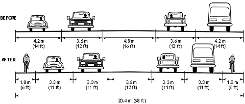
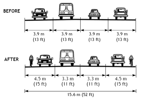
ODOT uses the guidelines in this section to determine how a roadway can be modified to accommodate bike lanes without significantly affecting the safety or operation of the roadway. The reduced travel lane widths are within AASHTO minimums. ODOT stresses the importance of using good engineering judgment when retrofitting bike lanes on existing streets. Reduction of Travel Lane WidthsThe need for full-width travel lanes decreases with speed (see figure 15-2):
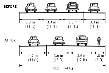
Reduction of the Number of Travel LanesMany one-way street pairs were originally two-way streets. This can result in an excessive number of travel lanes in one direction. A traffic capacity study will determine if traffic can be handled with one less lane (see figure 15-3).
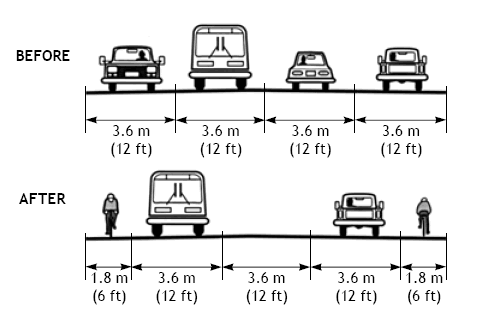
On two-way streets with four travel lanes and a significant number of left-turn movements, restriping for a center turn lane, two travel lanes, and two bike lanes can often improve traffic flow (see figure 15-4). This type of street reconfiguration is referred to as a road diet and is considered to be effective at calming traffic and providing space for bicyclists while still providing a reasonable vehicle LOS. Burden and Lagerway summarize the street and location criteria that can be used to identify potential candidates for road diets:(5)
Removal, Narrowing or Reconfiguration of ParkingA roadway’s primary function is to move people and goods rather than to store stationary vehicles. When parking is removed, safety and capacity are generally improved. Removal of parking will require negotiations with the local governing body (such as the city council), affected business owners, and residents. To reduce potential conflicts, careful research is needed before making a proposal, including:
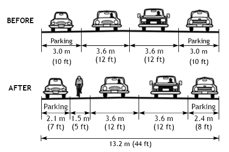
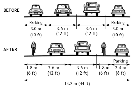
Instead of removal of all on-street parking, several other options can be pursued. Parking can be narrowed to 2.1 m (7 ft) (see figure 15-5), particularly in areas with low truck parking volumes.
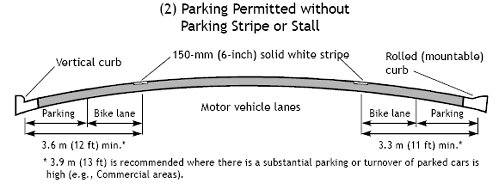
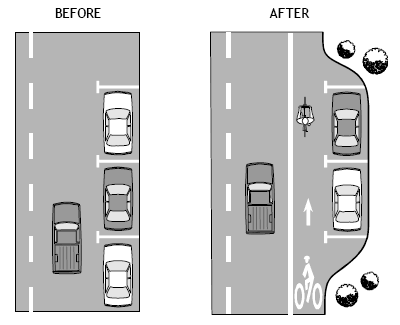
Bicycle lanes next to on-street parking can be problematic if enough space is not provided to prevent bicyclists from riding into an opened door. The AASHTO Guide recommends a combined width of 3.9 m (13 ft) for combined width of parking and bike lanes (see figure 15-1). In some cases, parking may be needed on only one side to accommodate residences and/or businesses (see figure 15-6). Note that it is not always necessary to retain parking on the same side of the road through an entire corridor.
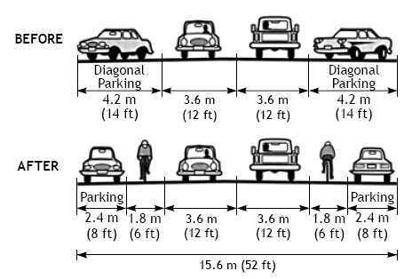
Diagonal parking takes up an inordinate amount of roadway width relative to the number of parking spaces provided. It can also be hazardous, as drivers backing out cannot see oncoming traffic. Changing to parallel parking reduces availability by less than one-half (see figure 15-7). On one-way streets, changing to parallel parking on one side only is sufficient; this reduces parking by less than one-fourth.
Most business owners cite the fear of losing potential customers as the main reason to retain on-street parking. Many cities have had success with ordinances prohibiting employees from parking on the street. This could help increase the number of available parking spaces for customers, even if the total number of parking spaces is reduced. Note that one parking place occupied by an employee for 8 hours is the equivalent of 16 customers parking for half an hour, or 32 customers parking for 15 minutes. Where all of the above possibilities of replacing parking with bike lanes have been pursued, and residential or business parking losses cannot be sustained, innovative ideas should be considered to provide parking, such as off-street parking. Other uses of the right-of-way should also be considered, such as using a portion of a planting strip where available (see figure 15-8).
Other Design OptionsNot all existing roadway conditions will be as simple to retrofit as those listed previously. In many instances, unique and creative solutions will have to be found. Width restrictions may only permit a wide curb lane (4.2–4.8 m (14–16 ft)) to accommodate bicycles and motor vehicles (see figure 15-9). Bike lanes must resume where the restriction ends. It is important that every effort be made to ensure bike lane continuity. Practices such as directing bicyclists onto sidewalks or other streets for short distances should be avoided, as they may introduce unsafe conditions.
Other minor improvements at the outer edge of the roadway should be made in conjunction with bike lane restriping, including:
Additional Benefits from Retrofitting Bike LanesSafety is enhanced as travel lanes are offset from curbs, lanes are better defined, and parking is removed or reduced. Adding bike lanes can often improve sight distance and increase turning radii at intersections and driveways. Restriping travel lanes redistributes motor vehicle traffic, which can help extend the pavement life, as traffic is no longer driving in the same well-worn ruts. Salem, OR, Case StudyA paper by Chuck Fisher contains information about how the city of Salem, OR, approached the retrofit of bicycle lanes in their city.(6) The first step in the retrofitting process was identifying which streets would make the best connections for bicyclists. In Salem, there is a lack of connectivity between the outer areas’ bicycle facilities and the downtown core. Particularly lacking are connecting bicycle lanes within 3 km (2 mi) of downtown, the area most likely served by increased levels of bicycling. Salem city staff recognized that retrofitting these older neighborhoods with bike lanes and removing all on-street parking would probably have created a political firestorm. As a result, the staff developed policies and methodologies that allowed for the mitigation of on-street parking demand. Policy Language. The relevant policy language is contained within the Goal, Objective, and Policies of the Salem Transportation System Plan’s Bicycle System Element:
The key phrase in the policy is the mitigation of parking demand, not supply. As part of the update of the plan, the staff developed criteria for ranking potential bike projects. Working with this list, the staff determined which projects were to be included for the next construction season. First and foremost, the staff surveys the existing on-street parking demand on the facility. Other data collection includes existing cross sections and on-street parking supply. Analysis activities included sketching cross-section design, locating alternative on-street parking locations, and developing initial project cost estimates. Public Involvement. At this point, the staff began a public involvement process that included neighborhood meetings, letters to abutting property owners, public workshops to determine alternatives, on-street sign notification, Citizens Advisory Traffic Commission meetings, and final approval by the City Council. Some of the alternatives presented by the staff at the meeting workshops included restriping the road to accommodate parking on one side instead of two. Neighbors were asked to help determine on which side of the street parking should remain, given that only half of the parking supply would be required to meet the demand. A variation on this would be to alternate the parking from side to side. For instance, if a six-block area required parking on one side, a solution might be to allow parking on one side for three blocks and then changing to the other side for three blocks. Another alternative would be to build parking bays, especially if only a small amount of parking mitigation would be required. Similar to bus bays or pull-outs, these would add the necessary room to accommodate parking in what had been the planting strip, between the curb and sidewalk.
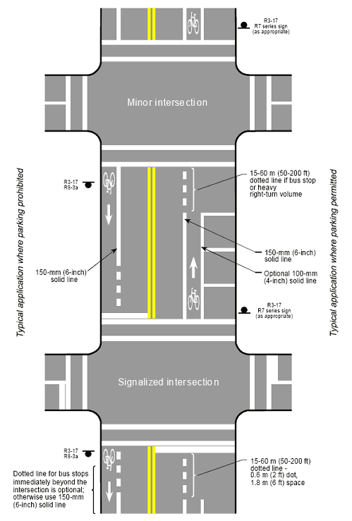
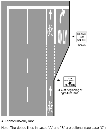
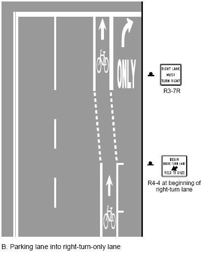
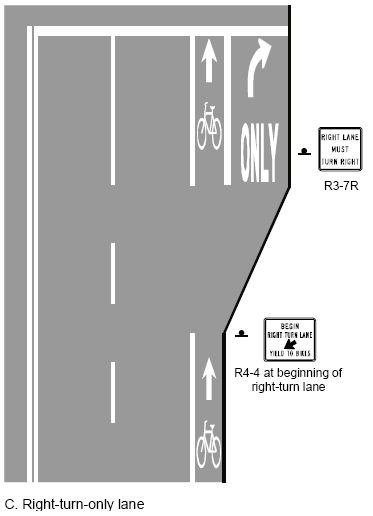
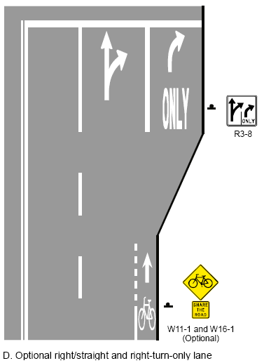
15.4 Bicycle Lanes at Intersections and InterchangesAt intersections and interchanges, bicyclists proceeding straight through and motorists making turns must cross paths. Lane striping and signing configurations that encourage crossings and merging in advance of the intersection are preferable to those that force a crossing or merging in the immediate vicinity of the intersection. The following paragraphs within this section provide guidance on bike lane design issues at intersections and interchanges. Intersections with Right-Turn LanesThe AASHTO Guide provides supplemental information about the design of bike lanes at intersections with right-turn lanes.(1) Figure 15-10 illustrates typical bike lane design and pavement markings at a variety of intersection approaches. There are several possible approaches for bike lane design where these right-turn lanes are present (see figure 15-11). The most desirable configuration will depend on the local road cross section and turning vehicle traffic patterns.
Figure 15-11. Illustrations. Possible configurations for bike lane and right-turn lane.
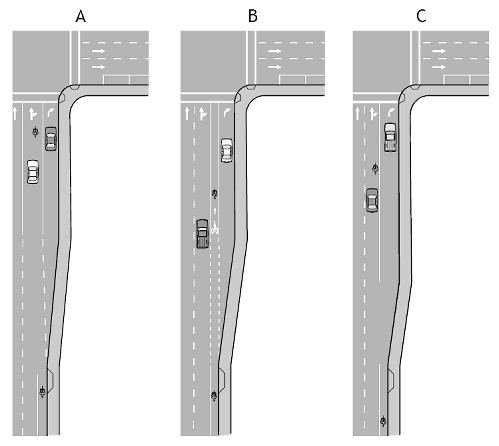
Dual right-turn lanes are particularly difficult for bicyclists. Warrants for dual turn lanes should be used to ensure that such lanes are provided only if absolutely necessary. The design for single right-turn lanes allows bicyclists and motorists to cross paths in a predictable manner, but the addition of a through lane from which cars may also turn adds complexity. Some drivers make a last minute decision to turn right from the center lane without signaling, thus catching bicyclists and pedestrians unaware. Several approaches to bike lane design with dual right-turn lanes are provided in figure 15-12. Design alternative A encourages cyclists to share the optional through-right-turn lane with motorists. Design alternative B guides cyclists up to the intersection in a dedicated bike lane. Design alternative C allows cyclists to choose a path themselves (this design is the AASHTO recommendation—simply dropping the bike lane prior to the intersection). Engineering judgment should be used to determine which design is most appropriate for the situation.
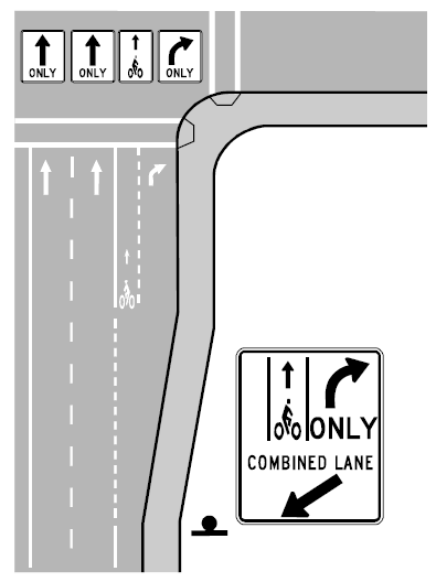
On bike lane retrofit projects where there is insufficient room to mark a minimum 1.2-m (4-ft) bike lane to the left of the right-turn lane, a right-turn lane may be marked and signed as a shared-use lane to encourage through-cyclists to occupy the left portion of the turn lane (see figure 15-13). This has proven to be most effective on slow-speed streets.
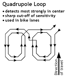
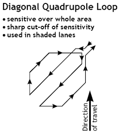
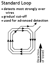
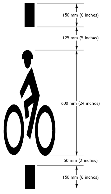
Intersections with Bus StopsIf there is a bus stop at the near side of an intersection, a broken white bike lane line between 15 and 60 m (50 and 200 ft) in length should be used, and the solid white line should resume on the far side of the intersection, immediately after the crosswalk (see figure 15-10). If a bus stop is located on the far side of the intersection, the solid white line on the far side of the intersection should be replaced with a broken line for a distance of at least 24 m (80 ft) from the crosswalk. Traffic Signal ActuationIt is recommended that new on-road bicycle facilities include traffic signals that detect bicycles for all actuated signal systems. The Traffic Detector Handbook recommends several bicycle-sensitive loop configurations (loops are wires installed beneath the pavement surface that detect the presence of vehicles) that can effectively detect bicycles.(7) The quadrupole loop is the preferred solution for bike lanes, and the diagonal quadrupole loop is preferred for use in shared lanes (see figure 15-14). A potential solution for existing intersection signals that do not respond well to bicycles is to install a special pavement marking over the exact spot that a bicycle must stop in order to activate the signal. MUTCD, 2003 edition, recommends a pavement marking that can be used to locate these sensitive areas covering loop detectors for bicyclists (see figure 15-15).(2)
Figure 15-15. Illustration. Example of bicycle detector pavement marking.
Expressway InterchangesExpressway interchanges often present barriers to bicycle travel. Designs that encourage free-flowing motor vehicle traffic movements are the most difficult for pedestrians and bicyclists to negotiate. Interchanges with access ramps connected to local streets at a right angle are easiest for bicyclists to negotiate. The intersection of the ramp and the street should follow established urban intersection designs. The main advantages of this approach are:
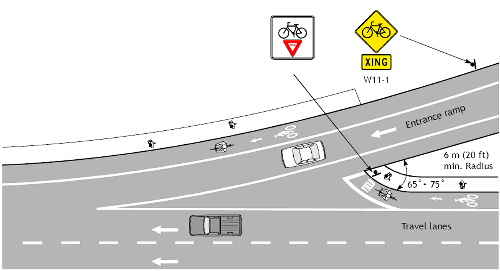
If these configurations are unavoidable, mitigation measures should be sought. Special designs should be considered that allow pedestrians and bicyclists to cross ramps in locations with good visibility and where speeds are low. Where it is not possible to accommodate pedestrians and bicyclists with at-grade crossings, grade separation should be considered. Grade-separated facilities are expensive; they add out-of-direction travel and will not be used if the added distance is too great. This can create problems if pedestrians and bicyclists ignore the facility and try to negotiate the interchange at grade with no sidewalks, bike lanes, or crosswalks. In some instances, a separate path can be provided on only one side of the interchange, which leads to awkward crossing movements. Some bicyclists will be riding on a path facing traffic, creating difficulties when they must cross back to a bike lane or shoulder (clear and easy-to-follow directions must be given to guide bicyclists’ movements if those movements are inconsistent with standard bicycle operation). The following concepts have been presented by ODOT as examples of innovative solutions to bike lane design at freeway/expressway interchanges and intersections.(3) Traffic entering or exiting a roadway at high speeds creates difficulties for slower-moving bicyclists It is difficult for bicyclists to traverse the undefined area created by right-lane merge movements, because:
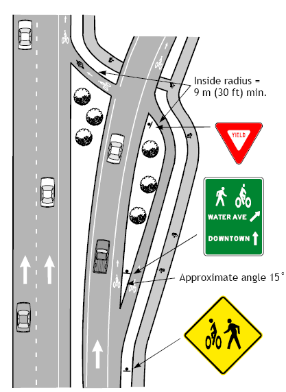
The design in figure 15-16 guides bicyclists at merging entrance ramps in a manner that provides:
Exit ramps present difficulties for bicyclists because:
The exit ramp design in figure 15-17 guides bicyclists in a manner that provides:
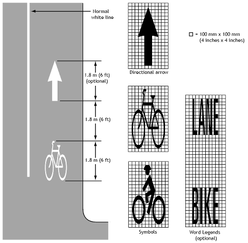
15.5 Bicycle Lane Pavement MarkingsSection 9C of MUTCD addresses numerous aspects of pavement markings for bicycle facilities.(2) Pavement markings typically consist of:
Care should be taken to use pavement striping that is durable, yet skid-resistant. Reflectors and raised markings in bike lanes can deflect a bicycle wheel, causing a bicyclist to lose control. If reflective pavement markers are needed for motorists, they should be installed on the motorist’s side of the stripe and have a beveled front edge.
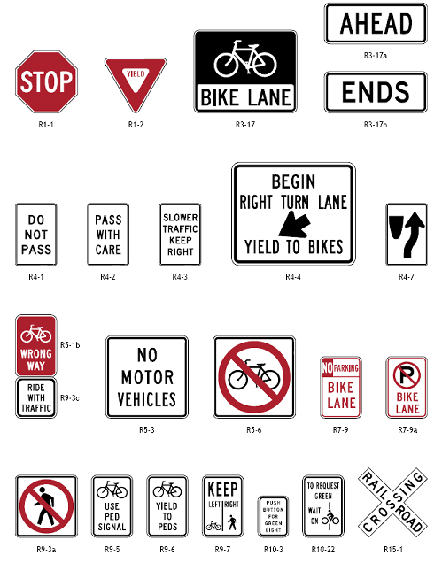
15.6 Bicycle Lane SigningMUTCD section 9B addresses standard bike lane signing. Figure 15-19 shows regulatory signs for bicycle facilities (including bike lanes). MUTCD also provides recommendations for warning signs and bicycle route guide signs. Key MUTCD signing principles for bicycle facilities are:
Figure 15-19. Illustrations. Regulatory signs for bicycle facilities.
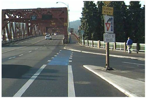
15.7 Other Design ConsiderationsColored Bike LanesColored bike lanes have been tested in two U.S. cities (Portland, OR, and Cambridge, MA) as a way to guide bicyclists through complex intersections as well as to make motorists aware that they are crossing a bike lane. The concept of colored bike lanes has been applied and is standard practice in several European countries such as The Netherlands, Germany, Denmark, Sweden, Switzerland, Belgium, and France (see lesson 23). A study of blue bike lanes in Portland, OR (see figure 15-20 for example), reached the following conclusions:(8)
Colored bike lanes have issues of maintenance—the paint wears quickly with vehicle traffic. As of 2004,the use of colored bike lanes has not been endorsed by any national design manuals or standards (such as the AASHTO Guide or MUTCD).
Contraflow Bike LanesContraflow bicycle lanes on a one-way street are not usually recommended. They may encourage cyclists to ride against traffic, which is contrary to the rules of the road and a leading cause of bicycle/motor vehicle crashes. There are, however, special circumstances when this design may be advantageous:
A contraflow bike lane may also be appropriate on a one-way residential street recently converted from a two-way street (especially where this change was made to calm traffic). For a contraflow bike lane to function well, special features should be incorporated into the design:
Under no circumstances should a contraflow bike lane be installed on a two-way street, even where the travel lanes are separated by a raised median.
Diagonal ParkingDiagonal parking causes conflicts with bicycle travel: Drivers backing out have poor vision of oncoming cyclists; parked vehicles obscure other vehicles backing out. These factors require cyclists to ride close to the center of a travel lane, which is intimidating to inexperienced riders. Where possible on one-way streets, diagonal parking should be limited to the left side, even if the street has no bike lane (on one-way streets with bike lanes, the bike lane should be placed adjacent to parallel parking, preferably on the right). Bike lanes are not usually placed next to diagonal parking. However, should diagonal parking be required on a street planned for bike lanes, the following recommendations can help decrease potential conflicts:
Some cities have found the use of back-in diagonal parking to be more effective along streets with bike lanes. With back-in diagonal parking, parking motorists are required to stop in the travel lane and back their car across the bike lane into the parking spot. When leaving the back-in diagonal parking, the motorists are in a much better position to see bicycles approaching the bike lane. This design alternative has not been widely used yet, and more experience will determine its effects on the safety and operation of bike lanes near parking.
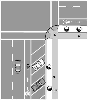
15.8 Practices to AvoidTwo-Way Bike LanesTwo-way bike lanes create a dangerous condition for bicyclists (see figure 15-23). They encourage illegal riding against traffic, causing several problems:
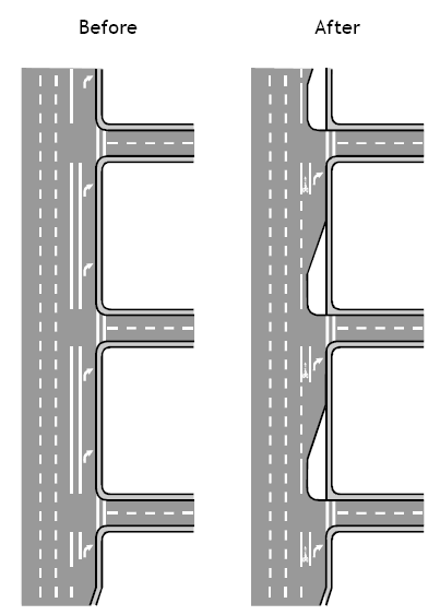
If constraints allow widening on only one side of the road, the centerline stripe may be shifted to allow for adequate travel lanes and bike lanes.
Continuous Right-Turn LanesA continuous right-turn lane configuration is difficult for bicyclists. Riding on the right puts them in conflict with right-turning cars, but riding on the left puts them in conflict with cars merging into and out of the right-turn lane. The best solution is to eliminate the continuous right-turn lane, consolidate accesses, and create well-defined intersections (Figure 15-24).
15.9 Student ExerciseExercise ARedesign a local intersection to include bike lanes. Choose an intersection with a moderate level of complexity, and assume that curb lines can be moved at will in order to achieve your design. Prepare a report and graphics that show existing conditions and your recommended modifications. Signalization changes (if necessary) should also be explained, as well as any advance striping and signing needed on the intersection approaches. Exercise BChoose a local urban street that would be a good candidate for a bike lane retrofit project. Redesign a two-block section of the roadway to include bike lanes (sketch drawings will be sufficient). Present at least two options for retrofitting the street, and include solutions that would require further traffic studies. Indicate proposed dimensions for travel lanes, parking lanes, and bike lanes. If removal of parking is one of your solutions, describe the public involvement process you would go through to achieve agreement from adjacent property owners and businesses.
15.10 References and Additional ResourcesThe references for this lesson are:
Additional resources for this lesson include:
FHWA-HRT-05-113 |