U.S. Department of Transportation
Federal Highway Administration
1200 New Jersey Avenue, SE
Washington, DC 20590
202-366-4000
Federal Highway Administration Research and Technology
Coordinating, Developing, and Delivering Highway Transportation Innovations
 |
| This report is an archived publication and may contain dated technical, contact, and link information |
|
Publication Number: FHWA-HRT-05-121
Date: July 2006 |
Federal Highway Administration University Course on Bicycle and Pedestrian TransportationPDF Version (350 KB) PDF files can be viewed with the Acrobat® Reader®
LESSON 19: GREENWAYS AND SHARED–USE PATHS
19.1 IntroductionShared–use paths provide low–stress environments for bicycling and walking that are separate from motor vehicle traffic. They can be great places for novice and child bicyclists to try out their bicycling skills prior to taking trips on urban streets. Shared–use paths are frequently in high demand among bicyclists, joggers, in–line skaters, people walking dogs, people with disabilities, and a variety of other users. Systems of shared–use paths in urban and suburban communities serve as the arterials of the bicycle and pedestrian transportation system. They serve as a complement to and extension of onstreet facilities (not as alternatives to them) and offer the protection from motor vehicle traffic that many Americans seek when looking to leave their car behind in favor of a bike, walk, or skate. The popularity of many urban paths has shown that large volumes of pathway traffic, with a diverse user mix, can create congested and conflictive path conditions similar to that on urban highways. Therefore, planning and design of shared–use paths must be done with the same care and attention to recognized guidelines and user needs as the design of on–roadway bikeways and other transportation facilities. The following discussion addresses planning and design issues common to most shared–use path facilities, including how to accommodate various user types, address different right–of–way settings, and achieve various safety standards and guidelines. More detail on shared–use path design and engineering is provided in national guidelines established by FHWA, the U.S. Architectural and Transportation Barriers Compliance Board (the Access Board), and AASHTO. See specific resources listed in section 19.11. The major sections of this lesson are as follows:
19.2 Shared–Use Path DefinitionThe term shared–use path is defined by AASHTO as "a bikeway physically separated from motorized vehicular traffic by an open space or barrier and either within the highway right–of–way or within an independent right–of–way. Shared–use paths may also be used by pedestrians, skaters, wheelchair users, joggers, and other nonmotorized users."(1) These facilities are most commonly designed for two–way travel. In many communities, shared–use paths may also be referred to as trails, multiuse trails, bike paths, hiker/biker trails, or other similar terms.
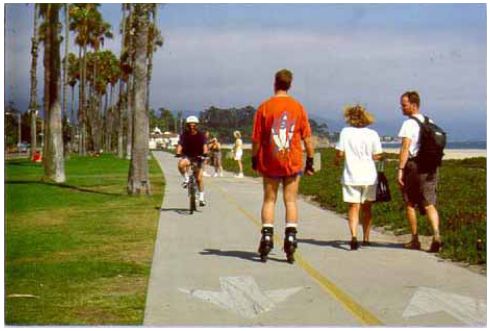
19.3 Shared–Use Path UsersShared–use paths are typically used by a diverse set of users representing different travel modes, using different types of equipment and traveling at different speeds (see figure 19–1). It is important to understand, even within the basic user categories of bicyclists, pedestrians, and skaters, how diverse path users can be. A recent study, Characteristics of Emerging Road and Trail Users and Their Safety, begins to document the various characteristics of these users and their equipment.(2)
Figure 19–1. Photo. To minimize user conflicts, adequate trail width is critical on paths having high volumes and diverse user mixes (Santa Barbara, CA).
In some communities, multiuse trails are designed and managed to accommodate equestrians, cross–country skiers, mountain bikers, and other users of specialized recreational activities. In general, the present discussion of shared–use paths does not specifically address the needs and issues of these more specialized user groups. Shared–use paths do not typically allow use by motorized vehicles such as cars, motor scooters, motorcycles, go–carts, or recreational all–terrain vehicles (ATVs); however, there are important exceptions to consider in planning and design:
Some shared–use paths may be appropriate for equestrian use. Some States claim that Federal law or regulation prohibits equestrian use on shared–use paths that use transportation funds. This is not true: there is no such Federal law or regulation. While the projects must serve a transportation function, nothing prohibits recreational use, and nothing requires a prohibition of equestrian use. There are various design options to allow equestrian use, such as providing both a paved path and an unpaved path within the same right–of–way. In addition to diverse users and a variety of equipment used, shared–use paths serve a wide variety of trip purposes. User behavior, such as travel speed and willingness to make stops, varies considerably with different trip purposes. Especially in urban and suburban areas, paths are routinely used for commuting to work or school, running errands, visiting friends, getting exercise, observing nature, and seeking recreation and enjoyment of the outdoors. Moreover, people of all ages and abilities use and enjoy shared–use paths—from the very young to the very old, from the novice cyclist to the marathon trainer. Accommodating and balancing the various needs created by this diverse user market is a central challenge for today’s shared–use path planners and designers.
19.4 User ConflictUser conflicts can emerge when user goals differ. In Conflicts on Multiple–Use Trails, Moore urges trail planners, designers, and managers "not to treat conflict as an inherent incompatibility among different trail activities, but as goal interference attributed to another’s behavior."(3) In addition to following good trail planning and design principals, Moore describes how user conflicts can be successfully minimized through effective path management. Understanding the diverse social and operational needs of expected users and designing trails to accommodate projected volumes and mode mixes is critical to building successful trail systems—trails that will serve multiple roles in a community’s transportation and recreation network.
19.5 Shared–Use Path Types and SettingsShared–use paths can be developed on a variety of rights–of–way and exist in many types of settings, including urban, suburban, exurban, and rural. Increasingly long paths use a variety of rights–of–way and pass through many diverse environments. The following is a list of the most common shared–use path types:
A wide variety of other facilities are often referred to by the terms path, pathway, or trail. They may share similarities with shared–use paths, but they are not addressed in this course. These include nature and interpretive trails, primitive and backcountry hiking trails, historic trails, heritage trails and touring routes, and walking paths.
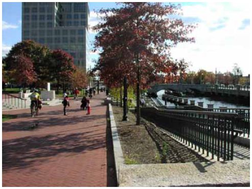
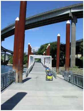
Figure 19–3. Photo. Shared–use paths can be integrated into urban waterfronts and parks, providing direct access to central business districts (East Bay Bicycle Path, Providence, RI).
19.6 PlanningGreenways: A Guide to Planning, Design and Development and Trails for the Twenty–First Century are two well–researched resources on the subject of planning that both emphasize its importance in the process of creating a shared–use path.(4,5) Three key objectives that should be addressed during the planning phase comprise communicating a clear vision, goals, and concept for the facility; building community support; and developing a comprehensive corridor assessment. Other plan components may include: documentation of community benefits and opportunities, environmental impact assessments, preliminary cost estimates, funding and phasing options, and implementation plans. Public involvement, interagency coordination, and interjurisdictional coordination should also be considered during early planning activities. Trails for the Twenty–First Century offers a helpful guide to planning process terminology and includes four key steps in the pathway planning process:(5)
Too often, agencies charged with creating a shared–use path fail to understand or adopt a crucial pathway planning principal—that by definition, shared–use paths serve both transportation and recreation functions. As such, they must be planned and designed to be a part of two systems of community infrastructure: parks and recreation, and transportation.
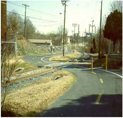
19.7 Rail–Trails, Rails–with–Trails, and TowpathsMore than 20,117 km (12,500 mi) and 1,200 rail and canal trails are now in place nationwide. More than 61 rails–with–trails and 25 towpaths are included in these totals. Unused rail and canal corridors offer many benefits as trail conversions, including gentle grades, existing base and sub–base for path construction, access to the center of communities, historic preservation and revitalization opportunities, scenic and natural resource preservation, and creation of social linkages from the past to the future. These types of pathways also present unique planning and design challenges. The following issues are especially important, since many of them have received extensive study and best–practice analysis (see "References" in section 19.11):
19.8 Greenway PathsThe most common feature of many greenways is a trail…with so many types of users in the United States, there are many types of trails, and elementary though it may seem, it is important to distinguish among them. All greenway trails should be compatible with the natural landscape and its functions.(4) What distinguishes the typical greenway path from other types of shared–use paths is that the path is only one component of a larger corridor, which is primarily defined by its environmental features or functions, including waterways, forests, wetlands, shorelines, or other natural or restored landscapes. Moreover, the reason that the corridor exists may not be primarily to create a context for a path, but for larger environmental purposes such as habitat preservation, to absorb and accommodate floodwaters, or to provide parkland and recreation resources for human communities. Greenway paths may be incorporated into built natural areas such as linear urban parks or parkways, along flood control levees or along urban waterfronts. Greenway paths can also be created in natural areas such as along beaches and shorelines, in conservation areas, or along stream or river corridors. Greenway paths present unique planning and design challenges. The following issues are especially significant, as many of them have received extensive study and best–practice analysis:
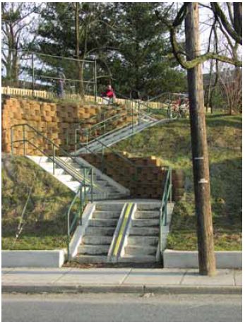
19.9 Paths Adjacent to RoadwaysIn select circumstances, locating shared–use paths adjacent to roads may be the best or only option available. In settings such as parkways or roadways with little or no access on one side and sufficient space to provide a path and buffer, locating paths adjacent to roads may be preferable to other options. Roads or streets that have low motor–vehicle traffic volumes and/or low traffic speeds can also be viable candidates for accommodating sidepaths, especially to provide continuity for a path that is otherwise on an independent right–of–way, but has critical gaps. However, in typical cases, if a two–way shared–use path is located immediately adjacent to a roadway, some operational problems are likely to occur. The extent of these problems will depend on the context and layout of the roadway, number and nature of cross–streets, driveways and access ramps, and adjacent motor vehicle travel speeds. The AASHTO Guide for the Development of Bicycle Facilities enumerates nine potential problems and safety issues that need to be given serious consideration when planning or designing a shared–use path adjacent to a roadway, as for example:(1)
19.10 Path DesignAASHTO’s updated (1999) Guide for the Development of Bicycle Facilities remains the primary design guide for shared–use paths. The MUTCD 2003 edition, "Part 9: Traffic Controls for Bicycle Facilities," is the primary source for guidance regarding signing and striping of shared–use paths.(6) A number of new publications provide supplementary information, including:
The following highlights address important trail design issues using references from the texts listed above. The AASHTO Guide should be used as a companion text for this module. Accessible Path DesignBecause shared–use paths provide a transportation function, all newly constructed shared–use paths should be built to provide access for people with disabilities. In addition, existing shared–use paths should be improved to enhance access whenever possible. Key issues for accessibility include trail access points, grade, cross–slope, street crossings, curb ramp design, railings, and signage. A single source of access guidance for shared–use trails has not been compiled; however, taken together, the sources above address the essential topics.
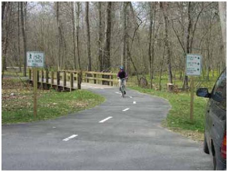
Trail Width and StripingUnder most conditions, the recommended paved width for two–directional trails is 3 m (10 ft); however 3.7– to 4.3–m (12– to 14–ft) widths are preferred where heavy traffic is expected (see figure 19–4). In select instances, a reduced width of 2.4 m (8 ft) can be adequate, especially if one or the other of the bicycle or pedestrian modes has a small percentage of overall use. A recent study, Evaluation of Safety Design and Operation of Shared Use Paths, found that from 3 to 4.9 m (10 to 16 ft), every additional foot in width significantly improves the LOS for bicyclists using shared–use paths.(11) This study also found that centerline stripes have a significant impact on how bicyclists tend to operate on shared–use paths: (11) A striped centerline has a strong impact on the bicyclist’s perception of freedom to maneuver. This finding appears to support the intent of trail designers in providing a centerline, which is to clearly delineate two opposing travel lanes. A centerline reinforces the idea that to pass a slower moving user, the cyclist may need to use the travel lane of opposing trail users, and should pass only when the opposing lane is open…there may be valid safety reasons for providing a centerline stripe, particularly on crowded trails, on curves with limited sight distance, and in other appropriate circumstances. Additional details regarding striping and marking of paths are found in MUTCD.
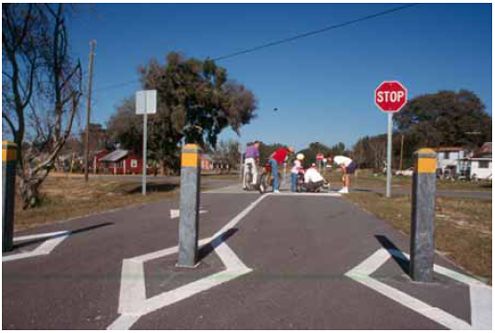
Trail/Roadway Intersection DesignAccording to page 46 of AASHTO’s Guide for the Development of Bicycle Facilities:(1) Intersections between paths and roadways are often the most critical issue in shared–use path design. Due to the potential conflicts at these junctions, careful design is of paramount important to the safety of path users and motorists alike. The solutions provided in this chapter should be considered guidelines, not absolutes. Each intersection is unique and will require sound engineering judgment on the part of the designer as to the appropriate solution. The following are principles of intersection design taken from Trail Intersection Design, AASHTO, and other sources:(13,1)
Other Design IssuesQuality shared–use path design requires a melding of skills from the fields of transportation engineering and landscape architecture. Guidance about basic engineering such as pavement structure, bridge loading, geometric design, and traffic safety must be combined with aesthetic, environmental, and cultural considerations such as attention to diverse human needs and the surrounding environmental and climatic conditions and integration with a community’s identity and history. The following list of additional design issues is addressed in one or more of the design resources provided in section 19.11; these issues can also be researched on the Internet for case examples and guidance from documents developed by regional, State, or local agencies.
19.11 Student ExerciseVisit and evaluate a trail facility in your area. Determine the positive elements and some of the issues of the facility, while paying close attention to the connection with on–street facilities, trail design, etc. Why might have the decision been made to build the facility in that manner, and what might be done to correct the issue?
19.12 References and Additional ResourcesThe references for this lesson are:
Additional resources for this lesson include:
FHWA-HRT-05-121 |