U.S. Department of Transportation
Federal Highway Administration
1200 New Jersey Avenue, SE
Washington, DC 20590
202-366-4000
Federal Highway Administration Research and Technology
Coordinating, Developing, and Delivering Highway Transportation Innovations
 |
| This report is an archived publication and may contain dated technical, contact, and link information |
|
Publication Number: FHWA-HRT-05-097
Date: July 2006 |
Federal Highway Administration University Course on Bicycle and Pedestrian TransportationPDF Version (327 KB) PDF files can be viewed with the Acrobat® Reader®
LESSON 7: ADAPTING SUBURBAN COMMUNITIES FOR BICYCLE AND PEDESTRIAN TRAVEL
7.1 IntroductionTypically, suburban areas in the United States are exclusively oriented to automobile travel. Most suburbs do not accommodate bicyclists and pedestrians, and they rarely provide good access to transit (with a few exceptions). With all this in mind, however, it is necessary to expand walking and bicycling travel opportunities in the suburbs without eliminating the car. Suburbs were organized around automobile travel and, in many instances, will not function well without it. This session explores methods of redesigning suburban communities to better accommodate nonmotorized transportation. It discusses how the suburbs developed, the hierarchy of the street system, and appropriate modifications that can accommodate and encourage bicycling and walking. It includes a discussion of Safe Routes to Schools programs, and how they can be utilized to focus attention on pedestrian conditions within suburban neighborhoods. This session is mostly oriented toward suburban planning considerations—with references to other sections that focus on design issues such as traffic calming and walkway/bikeway design. The major sections of this lesson are as follows:
7.2 History of Suburban DevelopmentBefore the automobile became a part of most American households, city dwellers relied on walking for their transportation close to home and on streetcars, trolleys, or trains for longer trips. The streetcar and railroad lines generally ran from cities to outlying neighborhoods where houses and businesses clustered near major stops. People usually walked from their homes to public transportation, much as they walked from home to the business district to do their shopping. As more and more people were able to afford their own cars, dependence on streetcars, trolleys, and trains diminished as did the need to live near them. Since land farther away from the city was less expensive, people from city neighborhoods began to see the fulfillment of a dream to own a detached home with land around it. When developers of these homes learned that people would be willing to drive a little farther to buy even less expensive land, leapfrogging began. Leapfrogging is the practice of developing less expensive land farther from the city while leaving vacant more expensive land closer to the city. Developers of schools, businesses, and parks also sought the least expensive land. Thus, the result was scattered facilities and communities with no central focus. Because suburban building became so scattered, streetcar and rail transit were less cost–effective, ending usually at the city’s edge, and the car became the main means of transportation for suburban residents. That suburban activities require the use of a car and generate a large amount of traffic is well known. In suburban commercial areas, heavy traffic starts early in the morning and lasts for the entire day until beyond the end of evening rush hour. Traffic is heavy because of the many trips from store to store made by shoppers who find driving between stores easier than walking or bicycling, even though distances may be short enough for these activities. Because of the active, internally generated traffic, walking, and bicycling are not safe, pleasurable, or convenient. Consequently, before viable pedestrian improvements can be made, all–day peak traffic must be corrected. The land use changes needed to remedy these conditions include increasing density and mixing land use, two actions residents of suburbs often believe are inappropriate for suburban lifestyles. Many communities have already begun to alter land regulations to prevent suburban sprawl. Apartments and commercial developments are now being built along arterials and on land bypassed by leapfrogging. The pattern of development in many suburbs is infilling. This present pattern of infill development is providing more opportunities for design to accommodate pedestrians and bicyclists and to promote bus transportation. In some regions where approaches to land use are not consistent between neighboring cities or counties, development may be concentrated in those jurisdictions with the least strict land use control. This development leads to megaleapfrogging, a good reason to promote land use controls on a regional basis. Here, three typical pedestrian problems—safety, function, and comfort—should be addressed. Safety problems are real or perceived conflicts as people cross streets or walk where there are no sidewalks. Since suburban drivers cover longer distances and drive faster, the dangers to pedestrians become magnified. The absence of pedestrians on suburban streets dulls drivers’ awareness and further aggravates the problem of safety. Functional pedestrian problems are found wherever there is little or no walking space, a lack of sidewalks, parked cars along the road’s edge, wide driveways, few benches, and barriers (see figures 7–1 and 7–2). Beyond this, another functional problem is the lack of destinations within reasonable walking distance. Finally, problems that create uncomfortable environments for pedestrians and bicyclists are: walking next to noisy, fast moving cars; poor vistas; few rest stops; streetscapes with little interest to someone who is not driving; and vacant lots or large parking lots that are visually dull and potentially unsafe.
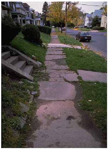
Figure 7–1. Photo. Inadequate maintenance of sidewalks makes a short walk difficult to maneuver.
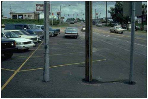
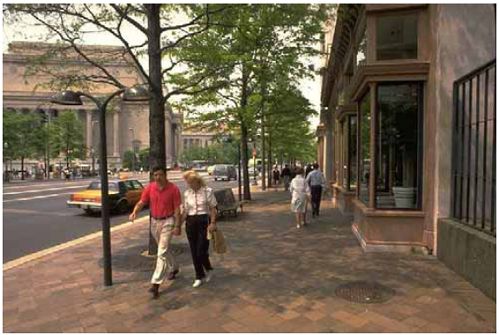
Figure 7–2. Photo. Parked cars and a lack of sidewalks along the road’s edge create unsafe conditions for bicyclists and pedestrians. Abandoning the StreetThe long driving distances necessary to serve low–density areas increase the speed and volume of suburban traffic, making streets dangerous and uncomfortable places (see figure 7–3). To counter this discomfort, an inside–out development pattern—the opposite of the prevalent urban development patterns—has evolved. While most urban communities focus on and utilize the street, suburban communities turn their backs to the street, and focus human activities on internal gardens, courtyards, and other private or internal, if open, spaces. Typically, car parking distances front doors from the sidewalk, and makes using the car seem most natural. Unfortunately, the internal spaces are seldom interconnected, so walking or bicycling for long distances through or between them is not often possible.
Figure 7–3. Photo. Sidewalks with a landscape strip should be installed to minimize exposure to vehicular traffic.
A shift has occurred from the urban grid pattern to a suburban road hierarchy. The grid typical of many cities allows free choice of routes but does not necessarily distinguish between high or low volumes of traffic or between streets that may or may not be good locations for raising families. With its system of roads, from arterials carrying high traffic volumes to cul–de–sacs with virtually no vehicular traffic, the suburban hierarchy changed all that. The secret of the hierarchy lay in not interconnecting streets, which positively directed through traffic to arterials. This made cul–de–sacs the preferred residential streets. Grid patterns developed when travel by foot was important. As the grid was infinitely divisible, it created a fine–grained network that benefited foot traffic. The hierarchy developed to accommodate the automobile by recognizing that cars can easily travel extra distances—as traffic disperses, certain roads should carry more or less traffic than others. Pedestrians, unfortunately, cannot easily travel longer distances, and are the losers. In its conceptual form, the hierarchy includes a separate and internal pedestrian system that purportedly ensures pedestrian access to different parts of the community. Unfortunately, these internal systems were not provided in most cases, and where they were, they did not lead to places people wanted to reach because those were located on the roads. Internal circulation spaces were often unsafe because they lacked foot traffic and the varied ownership made access dependent on private property rights. Remedying these conditions requires a strategy of: linking internal spaces where possible and making the street usable for pedestrians and bicyclists will enhance suburban living for many people.
7.3 Costs of SprawlSeveral groups have argued that the costs of suburban sprawl are much higher than alternative development forms, particularly when considering all of its externalities. In recent years, planners and researchers have begun to quantify the costs of sprawl to the environment and health of communities. In the first comprehensive study on the health effects of sprawl, a team of researchers found a close relationship between the type of community they live in, and their level of activity, weight, and health. One study, titled Relationship Between Urban Sprawl and Physical Activity, Obesity, and Morbidity, found that "people living in counties marked by sprawling development are likely to walk less and weigh more than people who live in less sprawling counties. In addition, people in more sprawling counties are more likely to suffer from hypertension (high blood pressure). These results hold true after controlling for factors such as age, education, gender, and race and ethnicity."(1) For more information on the costs of sprawl, please see the references at the end of this lesson.
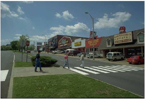
7.4 Present Suburban Land UsesSuburban land uses affecting pedestrians can be divided into three categories. First, there are individual tract subdivisions, planned as units, with a sense of order derived from the in–road systems. Access is limited to one or two points. Most are single–family residential, though some warehousing, shopping, and medical developments exhibit the same characteristics. The distinguishing characteristics are that each subdivision is a recognizable unit, planned as a whole, that can be replanned to better serve the pedestrian. The second type of land use is the linear arterial. While the roadway portion of arterials most likely was engineered, land use planning may never have occurred or may have been haphazard. However, arterials with these activities form the backbone of most suburban communities, serving both long–distance driving and local business transactions. Arterial strips often convey a sense of the community’s image or identity. While at present this image is seldom distinguishing or pleasant, it could be improved with pedestrian/bicycle–related amenities. Arterials are obvious locations for bicycle and pedestrian improvements since these roads pass most community facilities and are the only direct and relatively long through roads in the suburban community. However, most arterials have pedestrian safety and environmental problems that must be overcome. If these problems are too great, it may be possible to improve a route parallel to the arterial but one block removed. The third general type of suburban land use is bypassed land, forgotten during initial development as entrepreneurs leapfrogged out to find cheaper land. These lands infill more slowly and more haphazardly than planned subdivisions and are likely to have many owners and a variety of land uses, although perhaps not as many as along arterials. Bypassed lands may be the easiest to adapt to pedestrian– and bicycle–related improvements, as they typically have the highest densities, have mixed land uses, and are close to a variety of services. The most dangerous places for pedestrians are along suburban roads without sidewalks and intersection treatment. These roads are usually arterials located near schools, commercial areas, or businesses. Intersections of residential streets and other arterials that have no sidewalks or signals also contribute to risk. Moreover, bus stops are often located where there are no sidewalks, contributing further to pedestrian hazards.
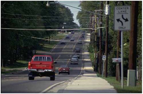
7.5 Planning With the Car in MindWhile suburbs were designed around the automobile (see figure 7–4), the car need not always be dominant and uncontrolled. Increased car use has constrained its own flexibility because roads have become more crowded and fuel costs have risen. Extending pedestrian and bicycle access within a community may eliminate some need for the car, allowing increased flexibility for those who have to drive. Walkways should be planned for physical and psychological safety from the auto, yet allow direct and easy access to all types of activities. Most walkways should be planned in conjunction with roads, so pedestrians can reach all developments that are located along the road.
Figure 7–4. Unless required by local ordinance, many developments focus on vehicle access without regard to pedestrian access.
7.6 Strategies for Retrofitting Suburban Arterial RoadwaysSuburban areas typically consist of many small residential developments, each abutting a major road. These major roads lead to services such as shopping, schools, and parks. Pedestrian and bicycle safety problems may be less of an issue inside individual suburban developments (unless they are large), but they increase on collectors and arterials both within and adjacent to neighborhoods. A variety of techniques are available to retrofit busy roadways to better accommodate bicycling and walking. Urban planners and design engineers have begun to apply very creative methods so that heavy volumes of traffic can coexist with pedestrian and bicycle activity. Examples are given in lessons 3 and 4 of this course. The following is an overview of techniques provided:
7.7 Safe Routes to School PlanningA Safe Routes to School program is a way to improve the safety of children who walk or bicycle to school and to promote these types of transportation. During a Safe Routes to School program, parents and school administrators work with other community groups and agencies to build new sidewalks, improve pedestrian crossings, teach children safer bicycling and walking skills, and promote healthier, more active lifestyles. The America Bikes campaign described the Safe Routes to School movement in the following way:
There are three distinct phases in each Safe Routes to School program. In the first phase, participants generate interest and enthusiasm about the project, and identify and assemble a core group of people who will help with the project. Often, this effort includes participation in Walk to School Day (held each October), or other promotional efforts. For the second phase, a group works together and conducts outreach to identify the types of improvements and safety programs that are needed. The third phase is implementation—that is, getting projects built, putting education and encouragement programs in place, and any other activities identified to make the journey to school safer.
7.8 Existing Retail/Office DevelopmentsEntrances to many commercial and retail centers are oriented toward automobile travel. Bicycle and pedestrian access to storefronts is not only difficult and awkward, but often unsafe. For the purpose of this discussion, a shopping center serves as an example of how to retrofit existing developments to accommodate pedestrians. The same principles apply to other types of developments such as office complexes and multifamily housing. A typical shopping center or strip mall is separated from the roadway by a wide parking lot that averages between 90 and 150 m (300 and 500 ft) in depth. Often, no pathways link store entrances to the sidewalks along the street, and sometimes there are no sidewalks on the street to be linked. Parking lots with multiple entryways allow traffic to circulate in different directions, creating hazards and confusion for walkers and cyclists. Drive–throughs at banks and fast–food restaurants in out–parcel developments add to pedestrian safety problems and encourage people to drive between different destinations on the site. Storefronts do little to encourage walking. They are often barren and devoid of windows and are therefore visually unappealing to a pedestrian (see figure 7–5). If they exist, walkways between stores are often narrow and uncovered, and pedestrian amenities such as benches are rare. Pedestrian connections between developments are not provided, encouraging shoppers to get back in their automobiles to access adjacent developments.
Figure 7–5. Photo. Building entrances and storefronts should be oriented to face the street.
Although the problems with shopping centers are numerous, they can be redeveloped to better serve pedestrians. As older shopping centers undergo renovations, they should be redesigned to serve customers who arrive via transit, automobile, bicycle, and on foot. Specific methods include:
Figure 7–6. Photo. Medians and crosswalks should be placed at destination locations such as this shopping center.
7.9 Student ExerciseDescribe 10 to 15 ways in which you would propose to retrofit a nearby residential development (or one that you grew up in) to make bicycling and walking viable forms of transportation. Elaborate on each idea, explaining how it would work and why it would improve the livability of the community.
7.10 References and Additional ResourcesThe references for this lesson are:
Additional resources for this lesson include:
FHWA-HRT-05-097 |