U.S. Department of Transportation
Federal Highway Administration
1200 New Jersey Avenue, SE
Washington, DC 20590
202-366-4000


Skip to content
Facebook iconYouTube iconTwitter iconFlickr iconLinkedInInstagram

Federal Highway Administration Research and Technology
Coordinating, Developing, and Delivering Highway Transportation Innovations

Report
This report is an archived publication and may contain dated technical, contact, and link information
Publication Number: FHWA-HRT-05-122
Date: July 2006

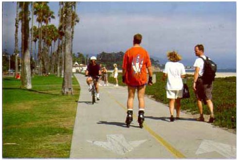
Lesson 19: Greenways and Shared–Use Paths

View Alternate Text


Lesson Outline

  • Introduction to shared–use paths.
  • Users of shared– use paths.
  • Path types and planning issues.
  • Shared–use path design.
Picture shows a broad shared use path along a river. A woman is jogging away from the viewer and there is a man rollerblading in the direction of the viewer.

Introduction to Shared–Use Paths

  • Importance of shared–use paths as a component of the nonmotorized transportation system.
  • AASHTO definition of a shared–use path.
  • Literature review.

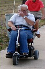
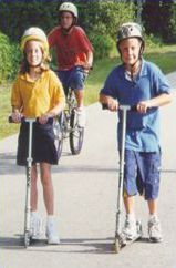
Users of Shared–Use Paths

  • Bicyclists:
    – Different equipment types.
  • Pedestrians:
    – Runners.
    – Persons with disabilities.
    – Others.
  • Skaters and others.
  • User conflict.
Second picture shows a father and child on a tandem bike pulling a second child in a trail-a-bike.

First picture shows a man on a motorized scooter.   The third picture shows two children on scooters. All the cyclists and scooter riders are wearing helmets.

Path Types and Planning Issues

  • Rail–trails.
  • Rails–with–trails.
  • Greenway trails.
  • Paths adjacent to roads.
  • Towpaths (canal trails).
  • Paths along utility corridors.
  • Paths in large developments.
  • Planning and project development process.
  • Unique planning issues for unique trail types:
    Converted rail and canal corridors.
    Paths adjacent to railroads.
    Greenway paths.
    Paths adjacent to roads.
  • Common community issues (examples):
    Personal security/fear of crime.
    Adjacent land uses and access.
    Traffic safety.
  • Paths serve both transportation and recreation.

Shared–Use Path Design

  • ADA accessibility.
  • Trail width and striping.
  • Traffic safety at trail/roadway intersections.
The graphic shows a cross section drawing of a bike path: Signage is placed three feet away from the pavement, the path is ten feet wide with a two percent cross slope. A centerline is optional, and on either side is a minimum two foot wide shoulder sloping down from the path.

The first picture shows a wheelchair lift for a pedestrian overpass.

The second shows a wide crosswalk with striping.


Trail Design Issues

  • Path surface and treadway design.
  • Geometric design.
  • Access and restrictions.
  • Safety adjacent to roads.
  • Environmental impacts.
  • Aesthetics.
  • Amenities.
  • Signs.
  • Structures.
Five pictures show trail elements. 1.) A picture of a tunnel that conveys a trail beneath a road. 2.) A “Yield to Bikes” sign. 3.) A town limit sign. 4.) A historic marker describing an event in the trails vicinity. 5.) A bronze plate used as a place marker for a significant site.

Lesson Summary

  • Shared–use paths provide car–free arterials in the pedestrian and bicycle network.
  • Path users are diverse.
  • Different path types present different planning challenges.
  • Trail design must serve both transportation and recreation needs.


FHWA-HRT-05-122

Previous | Table of Contents | Next

Federal Highway Administration | 1200 New Jersey Avenue, SE | Washington, DC 20590 | 202-366-4000
Turner-Fairbank Highway Research Center | 6300 Georgetown Pike | McLean, VA | 22101