Evaluation of Shared Lane Markings
CHAPTER 1. INTRODUCTION
BACKGROUND
Shared lane markings (also referred to as sharrows) help convey to motorists and bicyclists that they must share the roads on which they are operating. The purpose of the markings is to create improved conditions for bicyclists by clarifying where they are expected to ride and to remind motorists to expect bicyclists on the road. In the absence of bicycle lanes, motorists often neglect to safely share travel lanes with bicyclists, which can compel bicyclists to ride closer to parked motor vehicles. Such a scenario can result in a dooring crash if someone opens a vehicle door as the bicyclist passes. Also, when bicyclists stay to the far right in narrow travel lanes, passing motorists often track too closely to the bicyclists. This can be unnerving for bicyclists, leaving little margin for error, and sometimes leading to crashes.
In 2008, a recommendation was made by the National Committee on Uniform Traffic Control Devices (NCUTCD) to include shared lane markings in the next version of the Manual on Uniform Traffic Control Devices (MUTCD).(1,2) That recommendation was made with limited research conducted on an 11-ft spacing from the center of a shared lane marking to the curb.(3)
A literature review uncovered no additional research on other spacing options. The 2009 edition of the MUTCD includes provisions for shared lane markings, specifically the sharrow design, with guidance that the markings should be placed at least 11 ft from the curb face or the edge of pavement on a street with parallel parking. Further, on streets with no parking and an outside lane less than 14-ft wide, the centers of the sharrows should be placed at least 4 ft from the curb or the edge of pavement.(1)
The purpose of this study was to evaluate the impact of several uses of shared lane markings, specifically sharrows, on operational and safety measures for bicyclists and motorists. The following hypotheses were explored for sharrows:
- The markings may help indicate a preferred travel path and thereby improve bicyclist positioning relative to parked motor vehicles when riding in shared lanes with on street parking.
- The markings may help to improve spacing or operations when motorists pass bicyclists on streets both with and without parking.
- The markings could improve bicyclist positioning relative to the curb or other hazards along the roadway edge including unsafe drain grates or uneven pavement.
- The markings could be used in a situation where a bicyclist needs to take control of the lane, such as on a section of steep downgrade where more operating space is needed and there is not enough width to provide a sufficiently wide bicycle lane. Another such situation might be on a narrow lane where bicyclists need to move away from the door zone or other hazards.
- The markings may reduce wrong-way and sidewalk riding, which can cause collisions.
- The markings may increase the distance of motor vehicles in the travel lane from parked motor vehicles or from the curb or edge of pavement in the absence of bicyclists, thereby providing more operating space for bicyclists.
A technical drawing of the sharrow marking is depicted in figure 1.
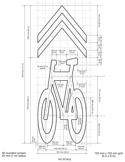
Figure 1. Illustration. Specifications for the sharrow from California MUTCD 2010.
EVOLUTION OF SHARED LANE MARKING DESIGNS
The original bike-in-house design that has been used or slightly modified in other locations for some time is shown in figure 2. This design was used in Gainesville, FL, in a wide curb lane situation and was previously evaluated by the Highway Safety Research Center (HSRC). It was found that the markings increased the safety margin for bicyclists riding near the curb. Additionally, sidewalk riding decreased.(4)
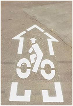
Figure 2. Photo. Bike-in-house marking.
The bike-in-house marking was modified to a bike-and-chevron marking, and the two designs were evaluated in San Francisco, CA. Superior results were associated with the bike-and-chevron marking shown in figure 3.(3) Based on feedback from bicyclists and motorists, the pitch on the chevrons was subsequently increased to resemble more of a directional guide. Given the results of the evaluation, the bike-and-chevron marking was added to the existing 2003 California Manual on Traffic Control Devices through a policy directive in September 2005.(5) Additional evaluation detail is provided in chapter 2 of this report.
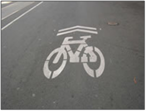
Figure 3. Photo. Bike-and-chevron marking.
NCUTCD issued a technical committee recommendation in January 2005 that proposed adding a shared lane marking section to part 9 of the MUTCD.(1,2) Afterward, the Bicycle Technical Committee of the NCUTCD recommended that this proposal be sent to the Federal Highway Administration (FHWA) in January 2007. The proposal suggested that shared lane markings should be used to prevent bicyclists from being struck by opened doors of parked motor vehicles (commonly referred to as dooring). Furthermore, it was recommended that the markings be placed 11 ft from the curb to encourage bicyclists to track over the markings and increase the distance between bicyclists and the door zone.
SITE SELECTION
At the beginning of the project, HSRC staff contacted communities who had expressed interest in evaluating different uses of sharrows. Staff visited Cambridge, MA; Portland, OR; and Seattle, WA, as well as local officials in Chapel Hill, NC. Based on the site visits, they sent a memorandum to FHWA recommending the following sharrow evaluations:
- Cambridge, MA: The sharrows would be placed 10 ft from the curb on a four-lane street with parking on both sides to determine if this location would improve spacing of bicycles and motor vehicles and also prevent dooring. The city has many street cross sections where the recommended 11-ft spacing from the curb would not be feasible.
- Chapel Hill, NC: The sharrows would be placed near the curb along the corridor of a busy street with a five-lane cross section (four travel lanes and a center two-way, left-turn lane) with no parking. The street had previously been resurfaced, and the outside lanes were marked nominally as 15-ft-wide lanes. Of primary interest would be the spacing of bicycles and motor vehicles from the curb and situations in which motor vehicles pass bicycles.
- Seattle, WA: The sharrows would be placed in the center of the lane on a downhill section of a two-lane street with parking on both sides. The placement was meant to encourage bicyclists to take the lane on the downhill section. The centerline of the street would also be repositioned to allow a 5-ft bicycle lane and a parking line to be installed on the uphill section of the street. Sharrows would be used in the downhill direction because there would not be enough space for bicycle lanes on both sides of the streets.
These recommendations were accepted by FHWA, and this report describes the sharrow evaluations for each location.
The actual design of the sharrow has been evolving, and figure 1 reflects the design used in Cambridge, MA, and Chapel Hill, NC. In Seattle, WA, a version that was a few inches longer was created and used in the evaluation. Figure 4 illustrates a generic sharrow as it appears in the 2009 version of the MUTCD.(1)
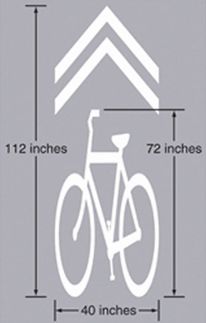
Figure 4. Illustration. Generic version of a sharrow.
|


