Evaluation of Shared Lane Markings
FHWA Contact: Ann Do,
HRDS-07, (202) 493-3319, ann.do@dot.gov
PDF files can be viewed with the Acrobat® Reader®
This document is a technical summary of the Federal Highway Administration report, Evaluation of Shared Lane Markings (FHWA-HRT-10-041).
OBJECTIVE
Shared lane markings help convey to motorists and bicyclists that they must share the roads
on which they operate. The markings create improved conditions by clarifying where bicyclists are expected to ride and by notifying motorists to expect bicyclists on the road. Figure 1 illustrates a generic sharrow as it appears in the 2009 version of the Manual on Uniform Traffic Control Devices (MUTCD).(1) The present study was sponsored by the Federal Highway Administration (FHWA), and its purpose was to evaluate the impact of several uses of shared lane pavement markings, specifically the sharrow design, on operational and safety measures for bicyclists and motorists. Experiments were conducted in Cambridge, MA; Chapel Hill, NC; and Seattle, WA. This TechBrief provides a summary of the findings from the research, and the corresponding main technical report (FHWA-HRT-10-041) provides additional details.(2)
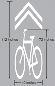
Figure 1. Illustration. Generic version of a sharrow.
BACKGROUND
In 2008, the National Committee on Uniform Traffic Control Devices recommended the inclusion of shared lane markings in the next version of the MUTCD.(3,1) That recommendation was made with limited research conducted only on an11-ft spacing from the center of the shared lane marking to the curb to prevent a bicyclist from striking an opening door of a parked motor vehicle (i.e., a dooring crash).(4) The 2009 edition of the MUTCD includes a provision for shared lane markings with guidance that the markings should be placed at least 11 ft from the curb face or the edge of the pavement on a street with parallel parking. On streets with no parking and an outside lane less than 14 ft wide, the centers of the shared lane markings should be placed at least 4 ft from the curb or edge of the pavement.(1)
Many cities and States have started implementing shared lane markings to encourage the safe coexistence of bicyclists and motorists. However, few localities have formally evaluated the impact of these markings on safety or operations. Given the opportunity to study shared lane markings, the Highway Safety Research Center (HSRC) decided to conduct a broad-based study. The following hypotheses were explored for sharrows by HSRC:
The markings may help indicate a preferred path of travel and thereby improve
bicyclist positioning relative to parked motor vehicles when riding in shared lanes with on-street parking.
The markings may help improve spacing or operations when motorists pass bicyclists on streets both with and without parking. The markings may help improve bicyclist positioning relative to the curb or other hazards along the roadway edge, including unsafe drain grates or uneven pavement. The markings could be used where bicyclists need to take control of the lane, such
as on a section of steep downgrade where they need more operating space and where there is inadequate width to provide a sufficiently wide bicycle lane. They could also be used in a shared lane situation or in a narrow lane situation where bicyclists need to move away from the door zone or other hazards. The markings may reduce bicyclist wrong-way and sidewalk riding, which can cause collisions. The markings may increase the distance from motor vehicles in the travel lane to parked motor vehicles or to the curb in the absence of bicyclists, providing more operating space for bicyclists.
Separate evaluations were conducted in three U.S. cities. In Cambridge, MA, there was interest in experimenting with the placement of sharrows 10 ft from the curb to prevent dooring from parked motor vehicles. In Chapel Hill, NC, sharrows were placed on a busy five-lane corridor with wide outside lanes and no street parking. In Seattle, WA, sharrows were placed in the center of the lane on a downhill portion of a busy bicycle commuting street. Prior to the sharrows, a 5-ft bicycle lane was added to the uphill portion of the street, and the center line of the street was shifted.
METHODOLOGY
The experimental design was to collect data of bicycles and motor vehicles operating in the traffic stream before and after installation of the shared lane markings. While it would have been desirable to have used an experimental design with comparison data, no adequate comparison sites were available. This is often the case in bicycle safety studies where slight differences in traffic flow, grade, pavement surface, or some other variable can greatly influence outcomes related to the bicyclists. One way to possibly obtain a comparison site is to install a treatment on part of a route and to use the remainder as a comparison. However, when a community is installing a treatment, almost invariably, the intention is to install the treatment along the entire route where the cross section is continuous.
Local staff collected videotape data before and after sharrow placement. The bicycle was the basic unit of analysis. A number of measures of effectiveness and other attributes were examined. Videotape coding was performed to obtain information about the bicyclist and to examine the operations of bicycles and motor vehicles when a motorist was following or passing a bicyclist. In Cambridge, MA, and Seattle, WA, events related to the presence of parked motor vehicles were also examined, such as existing open doors and near dooring events, as well as motorists pulling into or out of parking spaces.
The following spacing data were also obtained from images extracted from the videotapes:
Distance between bicycles and parked motor vehicles (tire to tire) Distance between bicycles and the curb at the edge of the road (tire to curb) where there was no parking. Distance between bicycles and passing motor vehicles (tire to tire). Distance between motor vehicles in the travel lane and parked motor vehicles (tire to tire) or the curb (tire to curb) when no bicycles were present.
Chi-square tests were used to examine the distributions of variables before and after placement of the shared lane markings. Analysis of variance models were used to study the effect of shared lane markings on spacing and other performance measures. In these models, the independent variables included site characteristics, type of treatment, and a dummy variable indicating whether it was a before or after condition. The sign and significance of the coefficient of this dummy variable were used to assess the effectiveness of the markings. None of the data were combined across sites because of differences in the uses of the shared lane markings in each city.
CAMBRIDGE, MA, EXPERIMENT
Cambridge, MA, has many street cross sections where the recommended 11-ft spacing from the curb would not be feasible. The sharrows were placed 10 ft from the curb for about 2,500 ft on Massachusetts Avenue, which is a 4-lane divided street with approximately 29,000 vehicles per day, parallel parking on both sides, and a speed limit of 30 mi/h. Figure 2 shows a view of Massachusetts Avenue before sharrows were placed on the street. The intent was to determine whether the sharrows would improve spacing of bicycles and motor vehicles and also help prevent dooring.
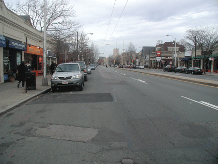
Figure 2. Photo. Massachusetts Avenue condition in the before period.
Results pertaining to the interaction of bicycles and motor vehicles included the following changes from before to after:
A total of 94 percent of the bicyclists rode over the shared lane marking. The percentage of bicyclists who took the lane decreased from 13 to 8 percent. The percentage of avoidance maneuvers (i.e., changing speed or direction to avoid another party) decreased from 76 to 37 percent. The percentage of bicyclists who yielded (i.e., gave way to a motorist) decreased from
23 to 7 percent. The percentage of motorists who yielded (i.e., gave way to a bicyclist) increased from
5 to 9.5 percent. The percentage of motorists who made no change while following a bicyclist increased from 44 to 65 percent.
Results pertaining to the spacing of bicycles and motor vehicles in the presence of a following motor vehicle in the after period included the following:
The distance from a bicyclist riding beside a parked motor vehicle increased from 40.1 to 42.3 inches when both directions were combined and increased from 37.4 to 41.5 inches for the inbound direction. Outbound spacing was 42.7 inches in the before period and 43.1 inches in the
after period. The percentage of bicyclists who rode within 40 inches (i.e., near the door zone) of parked motor vehicles decreased. Most of the effect was in the inbound direction with a decrease from 58 to 41 percent. Comparable outbound values were 44 percent in the before period and 38 percent in the after period. The percentage of bicyclists who rode within 30 inches (i.e., within the door zone) remained unchanged at 13 percent.
Results pertaining to the spacing of bicycles and motor vehicles in the absence of a following motor vehicle in the after period included the following:
The change in distance between a bicyclist and a parked motor vehicle was negligible (approximately 45 inches before and after). The percentage of bicyclists who rode within 40 inches of parked motor vehicles increased from 37.5 to 45 percent, although this may reflect the high percentage of bicyclists who rode over the sharrows. When motorists drove past parked motor vehicles in the absence of bicycles in the after period, the spacing increased 16 inches (from 77.4 to 93.6 inches) in the inbound direction, 12 inches (from 84.5 to 96.5 inches) in the outbound direction, and 14 inches (from 80.9 to 95.0 inches) combined.
Overall results from Cambridge, MA, indicate the following:
A total of 94 percent of bicyclists rode over the sharrows. There was more operating space for bicycles as motor vehicle spacing from parked motor vehicles increased. A number of variables related to the operations of bicycles and motor vehicles showed positive effects. Placement of the sharrows 10 ft from the curb (instead of 11 ft) was not a problem.
CHAPEL HILL, NC, EXPERIMENT
The sharrows were placed 43.5 inches from the curb along Martin Luther King, Jr. Boulevard (MLK) for 1.25 miles. MLK has a 5-lane cross section (4 travel lanes and a center two-way left turn lane) with no parking, 27,000 vehicles per day, a speed limit of 35 mi/h, and periodic sunken drain grates next to the curb. There was a 3 to 4 percent grade where the videotape data were collected. The street had previously been resurfaced, and the outside lanes were marked nominally as 15-ft-wide lanes. The spacing of bicycles and motor vehicles from the curb and in situations where motorists passed bicyclists was of primary interest. Figure 3 shows MLK in the before period.
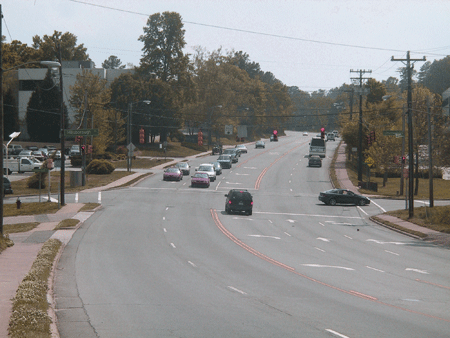
Figure 3. Photo. MLK in the before period.
Results pertaining to the interaction of bicycles and motor vehicles included the following changes from the before period to the after period:
A total of 91 percent of the bicyclists rode over the sharrows—97 percent in the downhill direction and 88 percent in the uphill direction. Bicyclists riding uphill traveled slower and tended to ride closer to the curb. The percentage of motorists who made no movement to change lanes when overtaking a bicyclist increased from 24 to 32 percent. There was no difference in the proportion of bicyclists riding near the curb (approximately 98 percent) or taking the lane (approximately 2 percent). The percentage of avoidance maneuvers decreased from 81 to 71 percent. The percentage of motorists staying in the lane when following bicyclists increased from 20 to 29 percent. There was no change in the percentage of bicyclists or motorists who yielded.
Results pertaining to the spacing of bicycles and motor vehicles included the following:
In the presence of a following motor vehicle in the after period, bicyclists rode closer to the curb after the sharrows by about 2.5 inches (40.1 to 37.7 inches). The effect was more pronounced downhill (4.6 inches closer) versus uphill (2.9 inches closer). Similar to Cambridge, MA, this was likely a reflection of bicyclists tracking over the sharrows. There were slight increases in the percentages of bicyclists who rode within 30 and
40 inches of the curb. The percentage within 30 inches increased from 12.5 to 15 percent downhill and 47.3 to 50.5 percent uphill. When motorists passed bicyclists in the after period, there was a small decrease in the passing distance overall from 82 to 79 inches. In the downhill direction, motorists passed 7 inches closer to bicycles (from 84.7 to 77.7 inches). There was no change in the uphill direction (from 80.0 to 81.1 inches). The percentage of passing motor vehicles within 50 inches showed only small and insignificant differences (from 2.0 to 2.6 percent). When the distance of the right front tires of motor vehicles from the curb in the absence of bicycles was examined in the after period, the spacing increased 8.3 inches in the uphill direction (from 64.4 to 72.7 inches), 4.7 inches in the downhill direction (from 76.6 to 81.3 inches), and 7 inches overall (from 70.5 to 77.0 inches). The percentages of motor vehicles within 50 and 60 inches of the curb were also significantly lower in the after period. The effect was most pronounced in the uphill direction (from 16 to 4 percent within 50 inches and from 46 to 17 percent within 60 inches). Bicyclist sidewalk riding significantly decreased from 43 percent in the before period to
23 percent in the after period. In the downhill direction, sidewalk riding decreased from 39 to 10 percent, with no significant change in the uphill direction. Wrong-way riding by bicyclists was 11 percent in the before period and 8 percent in the after period (nonsignificant change).
Overall results from Chapel Hill, NC, indicate the following:
A total of 91 percent of bicyclists tracked over the sharrows and rode at a safe distance from the edge of curb with more of an effect in the downhill direction. Motorists moved away from the sharrows, providing more operating space for bicyclists. A number of variables related to the operations of bicycles and motor vehicles showed positive effects. Bicyclist sidewalk riding decreased in the downhill direction. There was no change in the percentage of bicyclist wrong-way riding.
SEATTLE, WA, EXPERIMENT
Sharrows were placed in the center of the lane 12.25 ft from the curb on a downhill section of Fremont Street, which is a 2-lane street that has a speed limit of 30 mi/h, 10,000 vehicles per day, 3.6 percent grade, and parking on both sides of the street. The placement was meant to encourage bicyclists to take the lane while traveling downhill. Data were collected in two additional periods following the before period. The centerline of the street was repositioned to allow a 5-ft bicycle lane and parking line to be installed on the uphill section of the street
(after period 1). Sharrows were then added in the downhill direction (after period 2) since there was not enough width for bicycle lanes on both sides of the streets. Figure 4 shows a section of Fremont Street in the before period.
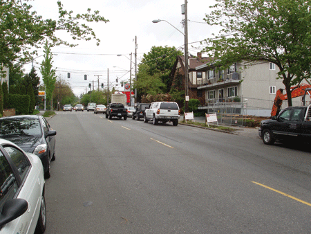
Figure 4. Photo. Fremont Street in the before period.
Results pertaining to the interaction of bicycles and motor vehicles included the following changes from the before period to the after period:
There was no difference in the safety of the manner in which motorists were following and passing bicyclists. Overall, 97 percent of these maneuvers were considered to be performed safely. A total of 15 percent of the bicyclists rode over the sharrow during the after period 2. A significantly higher percentage (51 versus 28 percent) of bicyclists shifted toward the center of the lane and took the lane during after period 1 when the lane was narrowed to accommodate the addition of the bicycle lane in the uphill direction. The percentage of bicyclists who yielded (i.e., changed direction or speed to give way to a motor vehicle) decreased from 3.3 percent in the before period to 2.8 percent in after period 1 and 0.7 percent in after period 2. The percentage of motorists who yielded (i.e., changed direction or speed to give way to a bicycle) decreased from 13 percent in the before period to 6.5 percent in after period 1 and 5 percent in after period 2.
Results pertaining to the spacing of bicycles and motor vehicles included the following:
In the absence of following motor vehicles, the average spacing between bicycles and parked motor vehicles did not significantly change across periods (45.8 inches in the before period, 47.5 inches in after period 1, and 44.5 inches in after period 2). The percentage of bicyclist spacing values within 30 inches (i.e., within the door zone) increased from about 6 percent in the before period to about 12 percent in the two
after periods. The percentage of bicyclist spacing values within 40 inches increased from 36 percent
in the before period to 39 percent in after period 1 and 44 percent in after period 2 (nonsignificant change). When motorists drove past parked motor vehicles in the absence of bicycles in both after periods, the average spacing decreased about 18 inches due to the change in the roadway configuration (the lane had been narrowed by 2.5 ft).
Overall results from Seattle, WA, indicate the following:
Sharrow placement alone did not seem to result in an increase in the percentage of bicyclists taking the lane. Bicyclists were already riding out of the door zone in the before period and stayed in this location in both after periods. Sharrows had previously been installed 11 ft from the curb next to parked cars over a 2,000-ft, four-lane section of Fremont Street leading into the section studied in the current project. It is possible that narrowing the travel lanes and adding the uphill bike lane had more of an effect on operations and spacing than the addition of sharrows. The bicyclists riding in the street seemed experienced and showed that it was not necessary to ride in the middle of the lane to control the lane.
CONCLUSIONS
Sharrows can be used in a variety of situations, and increased use should enhance motorist awareness of bicyclists or the possibility of bicyclists in the traffic stream. Results indicate that sharrows increased operating space for bicyclists. Sharrows have reduced sidewalk riding not only in the current study but also in a previous study in Gainesville, FL.(5) As communities continue to experiment with various uses of sharrows, it is recommended that researchers continue to create similar trials in other locations and traffic settings and then evaluate and report those experiments so that more data can be examined and guidance to users improved.
REFERENCES
-
Federal Highway Administration. (2009). Manual on Uniform Traffic Control Devices, Federal Highway Administration, Washington, DC.
-
Hunter, W.W., Thomas, L., Srinivasan, R., and Martell, C.A. (2010). Evaluation of Shared Lane Markings, Report No. FHWA-HRT-10-041, Federal Highway Administration, Washington, DC.
-
NCUTCD Bicycle Technical Committee. (2007). Proposed Shared Lane Marking Part 9 of
the MUTCD, National Committee on Uniform Traffic Control Devices. Obtained from: http://members.cox.net/ncutcdbtc/sls/slmtoncjan07.pdf. Site last accessed August 3, 2010.
-
Alta Planning + Design. (2004). San Francisco's Shared Lane Pavement Markings: Improving Bicycle Safety, San Francisco Department of Parking and Traffic, San Francisco, CA.
-
Pein, W.E., Hunter, W.W., and Stewart, J.R. (1999). Evaluation of the Shared-Use Arrow, Florida Department of Transportation, Tallahassee, FL.
Researchers—This study was performed by William Hunter, Libby Thomas, Raghavan Srinivasan, and Carol Martell of the Highway Safety Research Center of the University of North Carolina.
Distribution—This TechBrief is being distributed according to a standard distribution. Direct distribution is being made to the Divisions and Resource Center.
Availability—This TechBrief may be obtained from the FHWA Product Distribution Center by e-mail to report.center@dot.gov, fax to (814) 239-2156, phone to (814) 239-1160, or online at https://www.fhwa.dot.gov/research/tfhrc/programs/safety/.
Key Words—Shared lane markings, Sharrows, and Bicycles.
Notice—This document is disseminated under the sponsorship of the U.S. Department of Transportation in the interest of information exchange. The U.S. Government assumes no liability for the use of the information contained in this document. The U.S. Government does not endorse products or manufacturers. Trademarks or manufacturers' names appear in this report only because they are considered essential to the objective of the document.
Quality Assurance Statement—The Federal Highway Administration (FHWA) provides high-quality information to serve the Government, industry, and public in a manner that promotes public understanding. Standards and policies are used to ensure and maximize the quality, objectivity, utility, and integrity of its information. FHWA periodically reviews quality issues and adjusts its programs and processes to ensure continuous quality improvement.
|
|