U.S. Department of Transportation
Federal Highway Administration
1200 New Jersey Avenue, SE
Washington, DC 20590
202-366-4000
FHWA Resource Center
Office of Innovation Implementation
Adobe PDF Version of the Environmental Quarterly
Volume 2, Issue 4
October 2006
LETTER FROM THE EDITOR
Dear Environmental Colleague,
Fall is upon us and Daylight Saving Time will end soon (October 29). Next year, DST will be a month longer – thanks to the Energy Policy Act of 2005. I like to think you’ll use the extra hour you’ll get back from the return to Standard Time to read Environmental Quarterly. In this edition, we introduce a new tool for Indirect Effects Analysis (IEA) and Cumulative Effects Analysis (CEA) and share some photos in the Wetlands Scanning Tour results announcement. As always, we welcome your story ideas and submissions.
Sincerely, Don Cote
Environment Technical Service Team (TST) Leader &
Editor–in-Chief
Phone: (720) 963-3210
E-mail: Don.Cote@fhwa.dot.gov
INSIDE
• Greater Cleveland: DSS…p.1
• New GIS VISTA Tool by NatureServe… p. 3
• Dangerous Travelers….p. 5
• Crib sheets for IEA & CEA…p.7
• Wetland Scanning Tour Results Available…p. 8
• Environmental Calendar…p. 9
Greater Cleveland Decision Support System:
A pilot project to integrate watershed planning with transportation planning
By Brian Smith
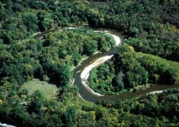
Photo of a forested stream reach within the Cuyahoga River watershed. Stream is in a backwards s shape. The surrounding trees are abundant and green.
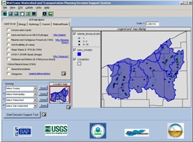
A sample image taken from a screen of the GIS Viewer which displays watershed boundaries and sampled sites.
Can Watershed and transportation planning be accomplished together in a cooperative manner while developing in a smarter, more sustainable manner? What can be done to help your community grow smart while incorporating transportation and watershed planning? To address these seemingly incompatible concepts, Midwest Natural Resource Group (MNRG) leaders charged their technical staff to develop a pilot decision support system that integrates watershed planning. The MNRG is a forum for Federal agency senior executives to obtain proactive coordination of Federal activities and build effective partnerships in support of the health, vitality and sustainability of natural resources and the environment. Several FHWA Division Administrators (DA) and Assistant Das participate in MNRG activities.
The project was funded by the Ohio Lake Erie Commission (Lake Erie Protection Fund) the USEPA and USGS. The Cuyahoga River Remedial Action (RAP) was the local project lead and USGS developed the tool (Programming, tool content, flow and datasets). Community stakeholders’ feedback was used to design a more effective and user-friendly DSS tool. The primary goal of the DSS is to provide environmental information in a visual and tabular form about the study area and affected watersheds. This type of information allows users to better evaluate the influence of transportation development on the environment. The DSS is an early planning (not project design) tool, and includes three components, 1) the GIS viewer, 2) the DSS output which includes tabular data of environmental features, watershed quality indicators and appropriate BMPs to consider, and 3) links to important documents and information such as BMPs and GIS metadata. The DSS is geared towards the non-GIS professional and providing access to environmental data and information to a large group of people early in the planning process.
The first step toward helping the Greater Cleveland area community grow smart while incorporating transportation plans and watershed management is to piece together all stressors, problems, issues and solutions into a complete picture.
The Resource Center, FHWA Ohio Division and ODOT support GIS technology for environmental streamlining and participated in initial development meetings as early as the fall of 2001. Now we have a great example of interagency cooperation, data sharing, and GIS technology. The next step is to showcase the capabilities of this DSS so that others can build on it and develop similar pilots with local watershed community partners. So far, the DSS has been highlighted by the Resource Center Environmental Technical Service Team at conferences including the 2006 FHWA Great Lakes Storm Water Workshop and Wetlands 2006 and also at 2005 GIS-T Symposium by Stephanie Kula of USGS.
Sources: Article contains excerpts from summaries prepared by MNRG. Other MNRG accomplishments can be found at the MNRG Website.
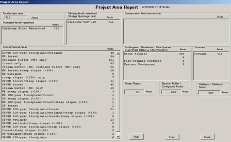
A sample image taken from the GIS viewer which displays tabular data of critical natural areas (e.g., forest, 100-year floodplain, wetlands, steep slopes, T&E species, etc.) within a selected HUC-14 watershed.
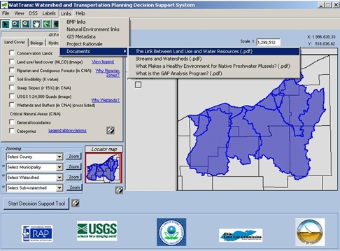
A sample image taken from the GIS viewer which displays a DSS menu that leads to BMP options and other informative documents.
Workshops Advance Delivery of Conservation and Transportation Benefits and Highlight GIS VISTA Tool
By Kimberly Majerus
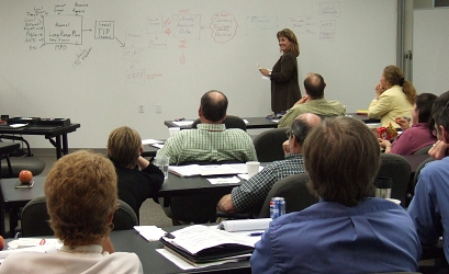
A photo taken during a workshop in which participants discuss and develop a flow chart of processes for transportation and conservation planning and next steps for the use of methods, data, and advancements in bringing processes together. Students are shown sitting at tables listening to the instructor. A flow chart is written on a white board behind her.
Pilot Workshops Unveil a New Geographic Information Systems-Based VISTA Tool as an Example to Support Decision-Making for Conservation and Transportation Benefits
Effective transportation balances diverse sets of information and responsibilities to deliver programs and projects in the field. Transportation practitioners need to respond effectively to an ongoing dynamic of improved practices, new requirements, and lessons learned within the profession. For more than a decade, computer tools and Geographic Information Systems (GIS) software have emerged to support these diverse tasks and responsibilities. Advancements in technology march forward. One of the challenges faced by transportation and environmental practitioners is to keep pace with these advancements and capitalize on new tools and methods as they become available.
FHWA has a new initiative with pilot workshops underway to facilitate discussions and capitalize upon the use of advancements in methods, data, and tools for conservation and transportation planning tasks and responsibilities. FHWA Office of Project Development and Environmental Review Office, FHWA Divisions, state departments of transportation, NatureServe, and Defenders of Wildlife are hosting workshops in 3 pilot states. The workshops facilitate an awareness of and use of improved methods, data, and tools for bringing together long-range planning for conservation and transportation and to support transportation program and project delivery. The Environment Team of the FHWA Resource Center is assisting with workshop delivery and presentations. Pilot states for workshops include Arizona, Arkansas, and Colorado.
Each pilot workshop highlights transportation and conservation planning and accomplishments within each state. For example, workshops introduce newly available State Wildlife Action Plans and highlight the benefits of state Natural Heritage Programs and the international and nationwide Heritage Network supported by the NatureServe, not-for-profit organization. Transportation practitioners from each state present an overview of transportation planning processes at the statewide and MPO levels. Facilitated workshop discussion identifies steps within transportation planning and decision-making processes that could benefit by inserting environmental information and coordination earlier and more thoroughly. Methods, data, and tools to support these steps are discussed.
A focus of the workshops is to demonstrate the use and benefits of a new tool as an example of a newly available advancement. Workshops unveil a new GIS-based, Decision Support System tool developed by NatureServe called VISTA. NatureServe is a not-for-profit organization that offers more that 30 years of experience in conservation and standardized methods and data within an international and nationwide natural heritage network for rare and endangered species and threatened ecosystems. The NatureServe VISTA tool delivers decision support system (DSS) and GIS capabilities to integrate conservation information with transportation and land use patterns and policies.
The VISTA software supports decision-making to create, evaluate, implement, and monitor plans that operate within the existing economic, social, and political context to achieve multiple goals. Workshops demonstrate and discuss how the NatureServe VISTA GIS-Based Decision Support System helps:
• evaluate scenarios and create plans that reflect unique situations and multiple values;
• develop mitigation plans and options for land use and management plans;
• improve the efficiency of planning processes;
• enhance the consistency and repeatability of planning efforts;
• improve stakeholder communications and build consensus with partners;
• develop documentation that supports decisions;
• manage projects through their complete lifecycle, including analysis, planning, implementation, and monitoring;
• reduce costly legal land use conflicts.
VISTA can also be integrated with other computer tools and various data sets. This capability is also demonstrated and discussed as an example within the workshop.
Workshops facilitate the use of information, tools and methods that can be shared between the transportation community, and the resource and regulatory agencies at the local, State, regional, and national levels. Workshop discussions and actions steps are summarized as the foundation of future efforts for each pilot state. After completion of the three pilot workshops, workshop summaries and presentations will be posted on the web. Pilot workshop discussions and demonstrations of tools and methods will be summarized and serve as cornerstones for successes and lessons learned to apply to advancements in linking conservation and transportation programs and planning processes.
Sources: This newsletter article contains excerpts from NatureServe summaries at the NatureServe Website and workshop materials.
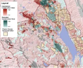
A sample image of a map being evaluated using the VISTA_GIS tool. Various scenarios can be evaluated using the VISTA GIS-based tool. The emphasis is identifying areas to protect to create important conservation corridors. Conservation corridors are shown as tan colored areas on this sample map. Source: The NatureServe Website
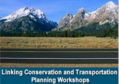
Image from a web site of workshop materials. Image shows a mountain range in the background of an empty two lane highway over a blue bar containing the title of the training course: Linking Conservation and Transportation Planning Workshops.
Dangerous Travelers:
Controlling Invasive Plants Along America’s Roadways
By Brian Smith
From The USDA Forest Service:
In the battle to control the rapid spread of invasive plants, the USDA Forest Service San Dimas Technology and Development Center in partnership with the National Forest System Invasive Species Program, the FHWA, the US Fish and Wildlife Service, and Penn DOT has developed a training video for road maintenance crews, Dangerous Travelers: Controlling Invasive Plants along America’s Roadways. This video will help maintenance crews recognize and control noxious weeds along roadsides. Road crews that maintain any type road, from interstate highways to aggregate roads, are the frontline in preventing the spread of invasive plants.
The video is available on the national invasive species program internet website.

An image of the cover of the Dangerous Travelers video. The title Dangerous Travelers is written in front of illustrations of a variety of plants and flowers.

A photo of Spotted knapweed. The plant has a purple flower with long thin petals loosely fanning out into a half-sphere shape above a green base and stem with a few small leaves.
“An invasive species is defined as a plant or animal, including its seeds, eggs, spores or other biological material that is non-native to the ecosystem under consideration and whose introduction causes or is likely to cause economic or environmental harm.” (Executive Order 13112)
As global trade and travel have increased, so too has the introduction of non-indigenous species around the world. While many of these non-indigenous species do not have adverse effects on the areas in which they are introduced, some become aggressive colonizers in their new ranges, disrupting ecosystem function, reducing biodiversity and degrading our nation’s natural areas. Today, thousands of invasive plants, animals and pathogens have infested millions of acres of U.S. lands and waters.
Invasive species are one of the greatest threats to our natural resources. At present, 400 of the 958 species listed as threatened or endangered by the federal government are known to have been negatively affected by invasive species (Wilcove et al. 1998).
Invasive species can damage native habitats by altering hydrology, fire frequency, soil fertility and other ecosystem processes. Some invasive species can also be harmful or poisonous to humans or livestock and can have negative impacts on agriculture.
In addition to causing environmental damage, invasive species have a large economic cost as well. It is estimated that invasive species cost the American public more than $138 billion per year in agriculture losses and control costs (Pimentel et al. 2005).
Invasive species can also hamper recreational opportunities by reducing access, degrading the quality of recreational areas and altering the aesthetic beauty of scenic natural areas. (From: Action Plan for Addressing Terrestrial Invasive Species Within the Great Lakes Basin, June 2006)
Resources and SAFETEA-LU guidance on the new eligibility of Federal-aid funds for control of invasive weeds and establishment of native species provisions under Section 6006 can be found at the FHWA Environment Website and the FHWA HEP page respectively.
Sources for this article include:
USDA Forest Service. Invasive Species Program. Dangerous Travelers. March 24, 2006. October 12, 2006.
Contest! PHOTO OPPORTUNITY 2007
Once again Greener Roadsides is hosting a contest to highlight the very best photos taken by Environmental Professionals nationwide. You may submit a photo in a variety of categories:
Contest Categories:
I – Planted Native wildflowers/grasses: Limit to native species in your area.
II – Planted Nonnative wildflowers: Include non-native or garden wildflowers introduced into an area. Photos of known invasive species cannot be accepted.
III – Protection: Show off preserved native remnant vegetation or endangered plants characteristic of your area. Explain how you are protecting them.
IV – Public Awareness: Collect photos, brochures, whatever explains your public outreach effort….please limit to 1-3 plastic sleeves.
V – Close-up: Chose your best plant species close-ups.
VI – Vegetation Management: Send examples of native woodland, wetland, or grassland restoration/mitigation, erosion control, reduced mowing results, landscaping, and integrated management methods for invasive species.
VII – Invasive Plants: Close-ups to identify, distant shots to show spread, or related activities.
VIII – Environmental Stewardship or Innovation. Demonstrating a land ethic OR a new idea that every state must hear about!!!
IX - NEW: includes Federal Lands roads, refuge roads, tribal roads, Turnpike and County roads’ vegetation projects.
Only very high quality digital photos are competitive. Your best photos might already be in your files!
SUBMISSION FORMAT:
• Send no more than 3 photos per category or 27 total.
• Each State may enter any one or all of the nine categories.
• Districts or individuals may enter through their State Agency.
• Type a cover letter about the program and the back-of-photo
information for legibility, please. Include State name.
• Submit 8x10 photos. These photos become the property of our files
for use in FHWA brochures, public awareness, etc.
• Provide a brief description on the back of each photo: (date, highway location, goal and/or names of key plants, State name and category.
• Protect photos by placing into plastic sleeves (for a 3 hole binder) when mailing.
• Submissions are due on November 10, 2007.
• Send to the Editor at FHWA, 380 Jackson St., Suite 500, St. Paul, MN 55101-2904. We suggest using a traceable method of mailing.
A multidisciplinary jury will review and determine the winners in December. Winners will be notified in advance of the general announcement of winners. Contest winners will be announced in the spring issue of GREENER ROADSIDES. NOTE: Editor’s Choice can be awarded to an overlooked-by-jury entry the Editor chooses to showcase.
Please direct questions to Bonnie L. Harper-Lore, Editor, (651) 291-6104, Bonnie.Harper-Lore@fhwa.dot.gov.

Cartoon drawing of a blonde man in a red shirt taking a photo of a scenic mountain range.
PHOTOGRAPHY Helpful Hints:
• Plan ahead and take your best shots from various angles.
• Give your State Photographer a list of seasonal roadsides to watch.
• Ask your District offices to help catch the best display at the best time.
• Shoot a close-up and a context photo when possible (gives you choices later).
• Pay attention to the light source and shadows.
• Include a highway reference in foreground or background.
IEA & CEA Checklists
By Kevin Moody
“Why don’t you put all of this information on a single piece of paper so that we have a crib sheet for developing work plans and reviewing documents?” said Tom Love of the Tennessee DOT. Leigh Ann Tribble, of the Tennessee Division, concurred. They had just spent over two and a half days helping to manage an Indirect and Cumulative Effects workshop in Nashville. The workshop emphasized the doing part of indirect and cumulative effects analyses, using the “best of” guidance from the Transportation Research Board, the Council on Environmental Quality, and included the points raised in key court cases.
Tom and Leigh Ann’s insight proved to be a winner. The result is two checklists or crib sheets, one to help with planning direct and indirect effects analyses (IEA), the other to help with cumulative effects analyses (CEA). These checklists are best used in tandem, so that a single evaluation considers both the direct or indirect (or, action-focused) effects of an action on a resource, and the cumulative (or resource-focused) effects as the perspective of the resource. Experience shows that the combined 19 steps identified on the checklists can be compiled into a much smaller number once practitioners have gained experience and understanding of the steps identified on the checklists, although documenting the thought process should not be discounted.
The Indirect and Cumulative Effects Analyses workshop developed by HEPE and the Resource Center Environment Team has evolved so that these worksheets form the foundation of participant’s understanding of this often confusing set of decision support tools. More importantly, by repeated uses of case studies, participants begin to understand the key elements of these analyses, and also how to efficiently integrate indirect and cumulative considerations into the NEPA umbrella. Headquarters, the Resource Center, and NHI are working together to begin offerings of this workshop as a standard NHI course in fiscal year 2007.
Indirect and cumulative effects analyses may be required under NEPA, Endangered Species act, section 4(f), and Clean Water Act section 404. The two follow the best practices for NEPA compliance, which is generally the basis of compliance with other laws and regulations.
For more information on use of the checklists, please contact any member of the FHWA Resource Center Environment Team, or Lamar Smith (Lamar.Smith@fhwa.dot.gov) or Mike Culp (Michael.Culp@fhwa.dot.gov) of HEPE.
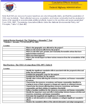
A sample illustration of the CEA checklist is pictured. The checklist has spaces to enter information in various categories under the headings of ‘The Judicial Review Standard: The Fritiofson v. Alexander test’ and ‘Best Practices the CEQ’s 11 steps.’ The checklist for IEAs is not pictured.
Wetland Scan Tour Results are in…
The final report on the FHWA Domestic Scan Tour of Successful Wetland Mitigation Programs is now available. The final report is posted on the FHWA website . The report describes how seven states are addressing their wetland mitigation issues. States visited by the interagency scan team included Texas, Pennsylvania, Minnesota, North Carolina, Kentucky, Nebraska, Ohio and Alabama.
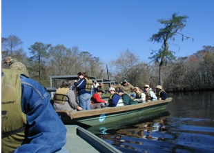
Photo of the multiple members of the scan team sitting in a boat while wearing life jackets as they charter the waters of Blue Elbow Swamp in Texas.
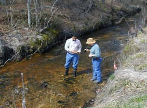
Two members of the scan team inspect the source of water to the Jumping Run Mitigation Bank site in NC while standing in the shallow stream.
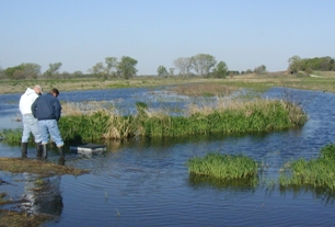
Two scan team members wade in the water as they check for critters at the Rock Creek Mitigation site in Nebraska.
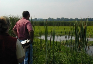
Two scan team stand and view the scenery as they prepare to investigate this wetland mitigation site in Nelson County, KY.
Calendar: What’s going on?
Here are a few of the upcoming events of interest to the environmental community:
November 2006
November 8 - 11
8th Cultural & Heritage Tourism Alliance Conference: Culture is the Spark
Atlanta, GA
Contact: Samantha Wallace at swallace@atlanta.net
January 2007
January 28 - February 1
2007 USDA-CSREES National Water Conference
Savannah, GA
February 2007
February 11 - 14, 2007
2007 NASCC Corps Forum
Washington DC
March 2007
March 6 - 8, 2007
2007 Trailbuilders Conference
Reno, NV
April 2007
April 10-13
National Mitigation Banking & Conservation
Conference: The Next Decade of Banking
St. Louis, MO
May 2007
May 13 - May 17
Coastal Sediments 2007
New Orleans, LA
May 20 - May 25
Int’l Conference on Ecology & Transportation (ICOET)
“Bridging the Gaps, Naturally”
Little Rock, AR
For additional conferences and events, see FHWA's Planning, Environment & Realty calendar
NEWSLETTER CONTACT INFORMATION:
Editor–in-Chief
Don Cote
Environment Technical Service Team (TST)
Team Manager
Phone: (720) 963-3210
don.cote@fhwa.dot.gov
TST Editorial Board Members:
David Grachen, Brian Smith, and David Sullivan
FHWA Resource Center
Aung Gye
Office of Project Development &
Environmental Review, FHWA HQ
Managing Editor:
Marie Roybal,
FHWA Resource Center
(720) 963-3241
marie.roybal@fhwa.dot.gov
Due to Quarterly publication schedule, all article submissions for future issues are due to the Editor-In-Chief by the 15th of March, June, September, and/or December

