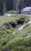
Originally constructed for wagon traffic, portions of the Generals Highway in California's Sierra Nevada Mountains have been in continuous use since 1926. The highway is one of only two main access roads into Sequoia and Kings Canyon National Parks (parks) and the only year-round access for visitors to Sequoia National Park. Building and maintaining roads while preserving a sensitive environment can be a difficult balance as is the case for this 46-mile-long primary visitor route. Original roadway construction changed the natural flow of water through Halstead Meadows, the largest meadow crossed by the Generals Highway.
The roadway embankment became a barrier interrupting historic flow patterns. The disconnected the water flow between upper and lower Halstead Meadow, severely impacted the rare wetlands ecosystem. Roadway construction concentrated flow through two culverts resulting over time into a notched channel over the entire length of the meadow. Adding to the challenge, both surface and ground water drains into the channel rather than percolating through the meadow which impacts the water table and the acres of wetlands.
Meadows make up only two percent of the Sierra Nevada, yet they serve critical roles: the foundation of many food chains as well as nursery, refuge and food source for numerous birds, insects, mammals and amphibians. Meadows are a unique natural environment; some plants and animals are not able to thrive elsewhere. In addition, water quality downstream depends on the filtering function of meadows.
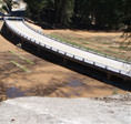
Committed to restoring the meadows, the Federal Highway Administration and the National Park Service (NPS) first step was to reestablish the flow by bridging the meadows. While several options were considered, a 250-foot 7-span concrete bridge was constructed to replace the restrictive dual 36-inch pipe culverts placed during the original construction.
Supporting activities include re-grading the meadow, replacing the former vegetation with native vegetation and filling in the eroded drainage channel. NPS is monitoring the vegetation and ensuring that the surface runoff does not drain into the formerly incised channel by using native material such as fill dirt, rocks, and logs to re-establish the sheet flow and prevent future erosion.
Across the country, many natural floodplains with wetlands and meadows have been affected by roadway construction. The historic approach was to convey the design storm through culverts. This approach prevents natural channel meander and modification and concentrates storm water to a singular location. This can in turn lead to erosion in adjacent areas.
Where feasible, spanning of the entire floodplain allows the channel to determine its natural path. By recreating a natural condition, wetlands and meadows can thrive, providing an ideal habitat for wildlife.