Potholes, cracks, bumps, and icy roads...all complaints that used to inundate the Arapahoe County, CO, Road and Bridge Department. "In winter months, we get as many as 30 calls a day from residents," said Paving Supervisor Keith Runyan. "It was difficult to track." Staying organized and on top of the reports is essential since the county requires workers to respond and take action within 72 hours.
When Runyan joined the Road and Bridge Department 6 years ago, there was limited coordination with the GIS Mapping Department. That changed once Runyan realized the asset that could be created if the two departments worked together. "I just started exploring other departments and started seeing what technologies they had available," he said. Runyan's curiosity paid off with the creation of the Pavement Repair Tracking Software App that offers access to crucial job information in real time.
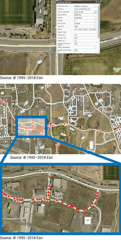
"Before this solution, we just had a running list of names and addresses. Now I can see everything on a map. It's so much easier to manage the workloads and put together daily, weekly, and even monthly work plans when you can look at it in a visual way rather than just in a spreadsheet. This powerful tracking system gives me the ability to identify work with status-indicating icons and details about the work. We can even attach photos. I used ASTM D6433 (a standard for assessing pavement defects) and created icons to match up with the type of pavement defect. For example, small alligators represent alligator cracks. This made it easier. I didn't want to look at a dot on the map and wonder 'what is this?'" said Runyan.
Crews can now monitor upcoming and completed pothole and major patch work on desktop computers and mobile devices. The app provides real-time map data viewing and collection anywhere in the county, while in the office or in the field. Multiple people can edit the system at the same time and data are exportable, so the information can be viewed in a map or a spreadsheet format.
The app gives supervisors the ability to go out in the field, get information for the team, and then easily prioritize projects. That way, crews know what they are going to see before they get there. They can determine the best repair method ahead of time and arrive prepared.
Because the app uses GIS data, there are more than 20 layers that track each category of information and can be turned on or off to simplify viewing or give multiple perspectives. In fact, the app is so beneficial, its use has spread to other departments.
How can another agency create a similar app? "The average GIS person can do whatever you want, but they don't know what you want," said Runyan. "You've got to be able to communicate that to them." Runyan is happy to speak with any transportation personnel who would like to learn from his experience.
"Don't be afraid to try new things," he said. "It helps us stay ahead of the curve."
For more information contact:
State: Colorado
Local Agency: Arapahoe County-Road and Bridge Department
Name: Keith Runyan
Position: Paving Supervisor
Telephone: 720-874-6821
Email: krunyan@arapahoegov.com
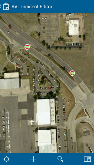
Screen capture of the mobile app.
Interface showing aerial view of the area with incidents marked.
Source ©1995-2018 Esri
Find a Center
Alabama Technology Transfer Center
website: http://eng.auburn.edu/atap/
Alaska DOT and Public Facilities Local Training & Assistance Program
website: https://dot.alaska.gov/ltap/
Arizona LTAP
website: https://www.azltap.org/
Arkansas Local Technical Assistance Program
website: https://cttp.uark.edu/technology-transfer/index.php
California LTAP Center
website: http://californialtap.org
Colorado LTAP
website: https://ltap.colorado.edu
Connecticut Technology Transfer Center
website: http://www.t2center.uconn.edu/
Delaware T2 / LTAP Center
website: https://sites.udel.edu/dct/t2-center/
Florida Local Technical Assistance Program (LTAP) Center
website: https://floridaltap.org/
Georgia Department of Transportation LTAP Center
website: http://www.dot.ga.gov/
Hawaii Local Technical Assistance Program
website: http://hidot.hawaii.gov/highways/other/hawaii-local-technical-assistance-program/
LHTAC T2 Center
website: https://lhtac.org/
Illinois Technology Transfer Center
website: http://idot.illinois.gov/transportation-system/local-transportation-partners/county-engineers-and-local-public-agencies/technology-transfer-center/index
Indiana LTAP
website: https://docs.lib.purdue.edu/inltap/
Iowa LTAP
website: https://iowaltap.iastate.edu/
Kansas University Transportation Center
website: http://kutc.ku.edu/ltap
Kentucky Transportation Center
website: https://www.kyt2.com/
Louisiana LTAP Technology Transfer Center
website: http://www.ltrc.lsu.edu/ltap/
Maine Local Roads Center
website: http://www.maine.gov/mdot/csd/
Maryland Transportation Technology Transfer Center
website: http://www.mdt2center.umd.edu/
Massachusetts LTAP - Baystate Roads Program
website:
https://www.umasstransportationcenter.org/umtc/Baystate_Roads.asp
Michigan Local Technical Assistance Program
website: http://www.michiganltap.org
Minnesota LTAP
website: http://www.mnltap.umn.edu/
Mississippi LTAP
website: https://mdot.ms.gov/ltap/
Missouri Local Training and Resource Center
website: https://mltrc.mst.edu/moltaphome/
Montana Local Technical Assistance Program
website: http://www.montana.edu/ltap/
Nebraska Local Technical Assistance Program (NE LTAP)
website: https://ne-ltap.unl.edu/
Nevada LTAP Center
website: https://www.nvltap.com
UNH - Technology Transfer Center
website: https://t2.unh.edu/
New Jersey Local Technical Assistance Program
website: https://cait.rutgers.edu/njltap/
New Mexico LTAP
website: https://www.dot.state.nm.us/content/nmdot/en/Planning.html#LTAP
Cornell Local Roads Program (New York LTAP)
website: http://www.clrp.cornell.edu/
North Carolina LTAP
website: https://itre.ncsu.edu/LTAP/
North Dakota LTAP
website: https://www.ndltap.org/
Ohio LTAP Center
website: http://www.dot.state.oh.us/Divisions/Planning/LocalPrograms/LTAP/Pages/default.aspx
Oklahoma Local Technical Assistance Program
website: http://ltap.okstate.edu/
Oregon Technology Transfer Center
website: https://www.oregon.gov/odot/programs/t2/Pages/default.aspx
PennDOT LTAP
website: http://www.ltap.state.pa.us/
Puerto Rico Transportation Technology Transfer Center
website: http://www.utrc2.org/institutions/puerto-rico-transportation-technology-transfer-center-prt2
Rhode Island LTAP
website: http://www.dot.ri.gov/about/RILTAP.php
South Carolina Transportation Technology Transfer Service
website: https://www.scltap.org/
South Dakota Local Transportation Assistance Program
website: https://www.sdstate.edu/jerome-j-lohr-engineering/sd-local-transportation-assistance-program
Tennessee Transportation Assistance Program
website: http://ttap.utk.edu
TxLTAP
website: http://www.txltap.org/
Utah LTAP Center
website: https://www.utahltap.org/
Vermont Local Roads Program
website: https://localroads.vermont.gov
U. Va. Transportation Training Academy
website: http://uva-tta.net/
Washington State LTAP Center
website: https://wsdot.wa.gov/business-wsdot/support-local-programs/local-programs-training
West Virginia Local Technical Assistance Program
website: https://www.wvltap.org/
Wisconsin Transportation Information Center
website: https://epd.wisc.edu/tic/
Wyoming Technology Transfer Center (WyT2/LTAP)
website: http://www.uwyo.edu/wyt2/
Bill Grants Federal Requirements Seminar ![]()
An introductory webinar to assist local and tribal agencies with applying for transportation funding under the Bipartisan Infrastructure Law (BIL).