

Archived: Interstate Technical Group on Abandoned Underground Mines
Third Biennial Workshop
Subsidence on 1-70 in Russell County, Kansas Related to Salt Dissolution: A Short History
Presented by
Neil M. Croxton2
Abstract
A short section of Interstate 70 in Russell County, Kansas crosses two active sinkholes. These sinkholes have slowly and steadily pulled down the driving lanes since construction of the highway in the mid-1960's. They are the result of dissolution of a thick salt bed over 1300 feet below the surface. Oil drilling activity has allowed fresh water to pass through the salt, dissolving a considerable volume of it and causing the overlying strata to sink. The two areas of interstate have been regraded at significant cost, and efforts were made in 1986 to stop the subsidence at one of the sinkholes, but the lanes continue to drop. Eventually, a nearby bridge will have to be replaced because of the subsidence. The Russell County sinkholes continue to be costly objects of attention to engineers and geologists at the Kansas Department of Transportation.
Discovery of the Crawford Sink
All highway construction in Kansas first has a geology survey. When geology crews began their preliminary studies for this section of 1- 70 in the early 1960's, there was a large pond along the right-of-way six miles west of Russell. They noticed that the pond appeared rather deep, and although it was situated in a streambed, apparently had no dam. Asking around among local residents, Highway Commission geologists were told that the pond had always been there. An 83-year-old woman who had lived in the area all of her life reported that there had been a pond in that location ever since she could remember. So little additional thought was given to the mysterious origin of the pond. During construction, it was filled in and the highway was built, along with a nearby bridge to carry county traffic over the interstate. Final grading for the new lanes was finished in the spring of 1966.
But something was wrong. Just east of the new bridge, exactly where the pond had been, the sub grade kept dropping. Since it was a stream crossing and a fill section, Highway Commission officials at first just assumed that the fill dirt was settling. But it wasn't just the lanes that were sinking. A few quick level runs confirmed the worst - the new interstate, the pride of Western Kansas, had been built right over a sinkhole.
The summer of 1966 was a busy one for our geology crews. While 1-70's lanes were being paved on either side, geologists and their technicians scrambled to find out what was causing the sinking. Someone thought to check air photos of the region that were taken in the 1950's. There was no pond. The locals had been wrong-the deep pond with no dam was a relatively new feature. And the State Highway Commission of Kansas had a big problem.
Cause of the Subsidence
1-70 in this area is aligned through the heart of the Gorham Oil Field. It is a very densely-drilled portion of the state, and although sinkholes hadn't caused much trouble at the time, geologists quickly suspected that the subsidence was caused by improper plugging of abandoned wells. Research into oilfield geology and deep groundwater movement led the Highway Commission to the cause-dissolution of the Hutchinson Salt Member.
This salt bed is Permian in age, a member of the Wellington Formation. In western Russell County, the Hutchinson Salt is 270 feet thick and its top is 1300 feet below the surface. Above the salt are three sandstone units-the Dakota Formation, the Cheyenne Sandstone Formation, and the Cedar Hills Sandstone Formation. All three have considerable flows of fresh or brackish water.
Oil wells in the Gorham field were drilled through the salt to a structural high in the Lansing-Kansas City Group and the Arbuckle Group. Hundreds of wells were drilled here beginning in the 1920's; many have since been abandoned. If an abandoned well is not plugged correctly, the fresh water flowing through the overlying sandstones pours down the borehole to replace water taken out of oil-producing layers by nearby active wells. On the way down, the fresh water washes across the salt face, dissolving it. The cavity in the salt grows, and eventually overlying beds sag downward until the depression shows up on the surface.
The sinkhole east of the bridge was named the Crawford Sink, after the Crawford oil lease. There are two wells 50 feet apart at the center of the sink. They are the Crawford 12 and Crawford 16. Both were drilled in 1937 and abandoned in the early 1940's.
Investigation of the Sinkholes
Geologists with the State Highway Commission of Kansas realized that the highway was probably safe as long as the sinking continued. But 1-70 was too important a project to take chances with, so during that summer of 1966, before the highway opened, a test hole was drilled. Geology crews drilled a core hole down 240 feet in the Crawford Sink. (This remains the deepest hole ever drilled by our crews). They found only solid bedrock the entire way. The geologist who logged the hole called them, "as perfect cores as you could ever find in that section". They also drilled and dug down to the Fencepost Limestone Member, which is close to the surface here. A structural contour map was drawn that showed the bowl-shaped drop in strata. Officials were reasonably sure that there was not a void under the highway which could suddenly collapse.
About that time, still before the highway was open, construction crews had more bad news: another section of road wasn't holding its profile. This area was a half-mile west of the Crawford Sink. The oil well responsible was the Witt A#1, just south of the right-of-way. This well was drilled in 1937 and plugged in 1957.
Highway Commission engineers and geologists got together late that summer to decide how to proceed. There was serious talk of rerouting the highway around the sinkholes, despite the enormous cost and delays. But the Gorham Oil Field stretches several miles to the north and south. Geologists told officials that there was no way to guarantee that a new alignment wouldn't just put 1-70 over other sinkholes. Since there apparently wasn't any danger to the public, the lanes in the subsidence area were paved that fall. Interstate 70 between Russell and Hays opened on schedule on November 16, 1966.
The next summer, the Highway Commission contracted with a drilling company to drill a deep exploratory well at the Crawford site. A crew with Rosencrantz-Bemis Drilling, of Great Bend, Kansas, drilled to 100 feet below the base of the Hutchinson Salt Member, a total of 1670 feet deep. Circulation was lost at 250 feet and never regained, which was attributed to washing of loose material at and below the Dakota Formation. Analysis of a radioactive gamma-ray neutron log indicated that the salt itself was washed along its entire thickness, and had been replaced by material from above. An anhydrite marker bed 350 feet above the salt had, at that time, already dropped 36 feet. Most importantly, however, was that very few voids were found, and none of these were large or near the surface. Officials told the public that the highway was safe, and that the sinkholes would cause only minor damage to the highway.
The 1970's
Nothing was done for a few years. The sinkholes continued to get deeper and broader, and the pond at the Crawford site reformed. The Witt Sink, which formed near the top of a ridge, created a noticeable depression. By 1971, the lanes had dropped so much that they had to be regraded. During the summer of that year, both areas were brought up 5 feet and repaved at the cost of 220,000 dollars. Elevations of the lanes and the bridge were taken every 6 months, making it the most surveyed section of road in the state. The highway continued to drop at almost 6 inches per year. Public relations in the area began to sour when local newspapers figured out that the subsidence showed no sign of stopping. Still, there was no danger, and so people gradually got used to sinkholes under 1-70. It became old news.
Overnight on May 1 or 2, 1978, however, a huge sinkhole suddenly opened up in a field 20 miles northwest of the 1-70 sinks. This hole, in northeast Ellis County, was also centered on an old well. In a few days, the hole was 75 feet across and 100 feet deep. The press coverage of the nearby sudden collapse forced the Highway Department, now KDOT, into action once again.
Our geologists were still reasonably sure that the gradual subsidence of the highway was a good indication that nothing catastrophic was going to happen to 1-70. But, primarily in response to public pressure, new studies of the problem were ordered late that year. The Kansas Department of Health and Environment (KDHE) and the Kansas Geological Survey (KGS) helped this time. Not enough money was available to do any deep drilling, but the KGS ran seismic surveys along both the 1-70 sinkholes and near the Ellis County collapse. Again, no near-surface voids were found beneath 1-70, and few deep voids. No satisfactory conclusions were ever drawn, however, as to why the Ellis County sinkhole behaved differently from the 1-70 sinks.
In addition, the KDHE took infrared air photos of the Gorham Oil Field to try to identify new sinkholes that might be developing. The idea was that shallow surface depressions would hold water after rainfall, and therefore have lusher vegetation. Regular air photos were taken early in the morning and late in the afternoon, to try to find new sinks highlighted by shadows cast by the low-angle sunlight. Neither of these endeavors yielded much useful information. The Hays Daily News took credit for instigating the investigations; the uproar finally died down.
Attempt to Stop Subsidence at the Witt Sinkhole
By August of 1984, the lanes at the Witt sink were back down 8 feet. It was starting to cause sight distance problems--engineers were afraid that a stalled car at the bottom of the depression would be rear-ended. So the Witt was again regraded and repaved at a cost of nearly 500,000 dollars.
KDOT engineers in that district were beginning to get more and more concerned. There didn't seem to be any end to the subsidence, and public relations in the Hays-Russell area were a serious problem. In January, 1986, the state again contracted with a drilling company. The goal this time was to stop subsidence at the Witt sinkhole.
A hole was drilled 4 feet west of the old Witt A#l well. Drillers attempted to shut off the flow of water across the salt by cementing shut the hole below the salt. Over 30 cubic yards of cement were pumped down the new hole, until pressure built up. Satisfied that the breach below the salt had been sealed, officials resumed their frequent surveys of the lanes. And in fact, it worked-for a while. For 6 months, the lanes didn't move. But somehow, water got around the plug and the highway quickly resumed its subsidence of 5 to 6 inches a year.
In 1988, more cement was pumped down both holes at the Witt sink. This cement was saturated with salt in the hopes that it would bond to the salt face itself. After "lubricating" the hole and cavity with 200 sacks of bentonite, drillers pumped almost 100 cubic yards of the salt-rich cement down the holes. Eventually, pressure built up to 300 psi in both wells at the same time. The voids in the immediate vicinity of the of the boreholes were filled, and KDOT geologists were again cautiously optimistic. Again, their optimism was short-lived, because water soon ate another hole in the salt and the subsidence continued.
Nothing has been done at the sinkholes since this attempt to stop movement at the Witt sink. A drilling program of several holes in a circular pattern around each original well hole would probably give the best chance of stopping the subsidence. No one can guess the quantities of cement or other fill material that would be required to fill the voids at depth. Of course, the cost of such an undertaking is a concern, especially since there is no guarantee that it would succeed.
The Bridge
The highway in the vicinity of the Witt sink can be regraded as many times as necessary. The Crawford sink is a different matter. It can't be regraded any more because of clearance requirements under the nearby bridge; the bridge is sinking, too. One end has dropped over 6 feet since it was built in 1965. At the south abutment, the east curb is now 2 feet higher than the west curb. Strangely, about the only indication that the bridge is under any stress at all is narrow cracks in the curbs just over the piers. Otherwise, the structure looks like any other 35-year-old bridge in Kansas. Our bridge engineer says it could last another 25 years.
The Future of the Russell County Sinks
Something will eventually have to be done at the Crawford sink. Either it will finally subside enough to become a sight distance problem, or water will begin to cover the roadway during storms. Since the only thing preventing us from regrading the Crawford area is the presence of the bridge, the logical step is to relocate the county road and build a new bridge at another location. Then the subsidence at the Crawford area, like at the Witt, could simply be countered by adding fill to the roadbed every so often. We recently discussed with Russell County the possibility of moving the bridge a quarter-mile west, to the area between the two sinkholes.
Meanwhile, traffic continues to go over the sinks at a count of over 11,000 vehicles a day. The Witt sink continues to drop at 5 inches a year; the Crawford is subsiding at about 4 inches a year. They will keep sinking until the Gorham Oil Field is finally abandoned and water is no longer drawn out of the strata below the salt.
Summary
Improper plugging of abandoned oil wells in Russell County led to the development of two large salt-related sinkholes beneath Interstate 70. The Kansas Department of Transportation has struggled with costly, embarrassing repairs and a failed attempt at remediation during the 35-year history of the highway. Despite knowing in detail the cause of the subsidence, an economical solution has eluded us. At present, KDOT plans to simply regrade the lanes for as long as possible. The sinkholes will continue to consume our time and resources well into the 21 5t century.
Acknowledgements
Most of the information presented in this paper was taken from records and reports on file at the KDOT Geology Section in Topeka, Kansas. In addition, the author would like to acknowledge valuable information gained from interviews with the following individuals, all of whom work or have worked for the KDOT: Mr. Wally Taylor, Regional Geologist, northwest region (retired); Mr. Larry Rockers, Chief Geologist (retired); Mr. Ron Sherard, Area Engineer at Hays; Mr. Lynn Washburn, Bridge Evaluation Engineer; and Mr. Wes Moore, District Maintenance Engineer at Norton. Recognition is also given to the Photo Section in Topeka for their assistance in preparing the slides for the presentation.
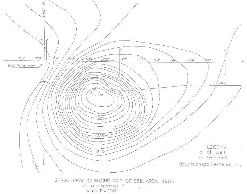
Figure 1: Structural contour map of Crawford Sink made soon after its discovery. (Click on image for larger version)
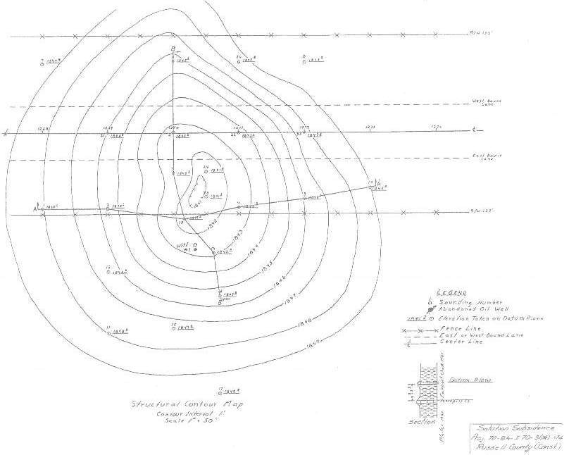
Figure 2: Structural contour map of Witt Sink from 1966. (Click on image for larger version)
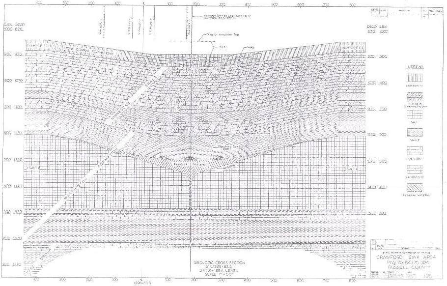
Figure 3: Cross-section of Crawford Sink, drawn after initial deep study in 1967. (Click on image for larger version)
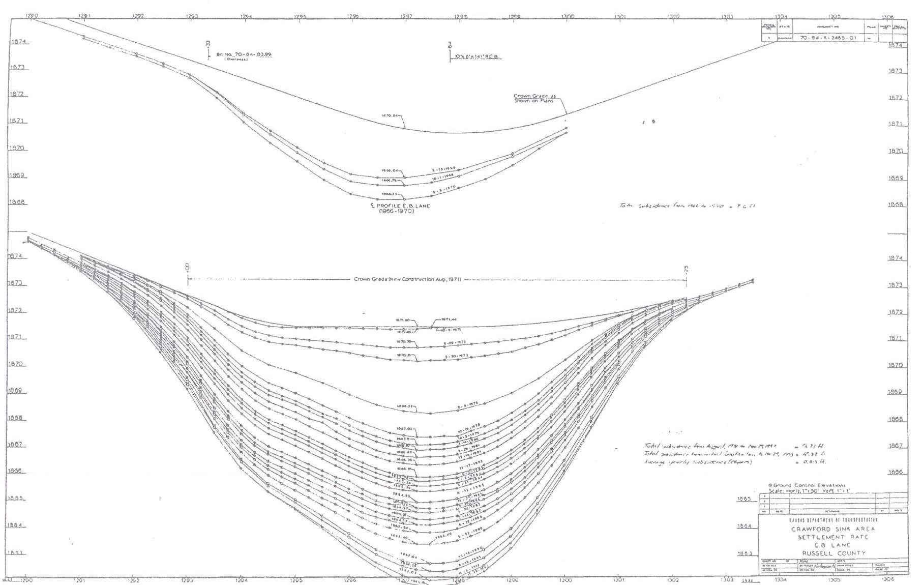
Figure 4: Profile of eastbound lanes of I-70 at the Crawford Sink. Upper graph shows settlement from 1966 to 1970. Lower graph covers from 1971, when lanes were regraded, to 1993. Total subsidence from the eastbound lanes during those 27 years was 12.3 feet. (Click on image for larger version)
Notes:
1 Presented at the KDOT 2000 Abandoned Underground Mine Workshop in Kansas City, Missouri, April 25-27, 2000.
2 Neil M. Croxton is the KDOT Regional Geologist for the northwest portion of the state, including the subject area.