U.S. Department of Transportation
Federal Highway Administration
1200 New Jersey Avenue, SE
Washington, DC 20590
202-366-4000


Skip to content U.S. Department of Transportation/Federal Highway AdministrationU.S. Department of Transportation/Federal Highway Administration

Highway History

Gallery Search Results
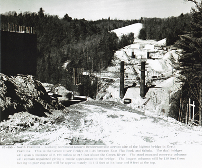
Search criteria:

Image File Name:

nc_4_I26_fhwa_1967_450.jpg


Year:
1967

State:
NC

Inter 1:
I26

Inter 2:
I26


Keywords:


Back to Search Page

Download Image

North Carolina - Looking northwest toward Hendersonville across site of the highest bridge in the State.  This is the Green River on I-26 between East Flat Rock and Saluda.  The dual bridges will span a distance of 0.198 miles at 218 feet above the Green River.  The steel encased concrete columns will remain unpainted, giving a rustic appearance to the bridge.  The longest columns will be 139 feet from footing to pier cap and will be approximately 13 1/2 feet at its base and 9 feet at the top.

North Carolina - Looking northwest toward Hendersonville across site of the highest bridge in the State. This is the Green River on I-26 between East Flat Rock and Saluda. The dual bridges will span a distance of 0.198 miles at 218 feet above the Green River. The steel encased concrete columns will remain unpainted, giving a rustic appearance to the bridge. The longest columns will be 139 feet from footing to pier cap and will be approximately 13 1/2 feet at its base and 9 feet at the top.


Download Image
Updated: 04/14/2020
Federal Highway Administration | 1200 New Jersey Avenue, SE | Washington, DC 20590 | 202-366-4000