

Equivalent Approach: Arkansas Preliminary Environmental Review (PER)
Criteria 1: Institutionalized Process
Equivalence Criteria Met
- Institutionalized Process
- Required:
- The early and continuous coordination with regulatory and resource agencies
- Public and stakeholder coordination
- Description of planning scope and vision statement
- Alternatives that were considered, selected, and rejected
- Explanation of planning assumptions
- Recommended:
- Analysis of the affected environment and environmental consequences
- Potential strategies for broad-scale mitigation
- Description and/or analysis of potential cumulative effects
- A method of documenting FHWA approval
The AHTD has been utilizing this process of early constraints mapping and coordination for several years. It has proven itself to be a valuable process on many large scale Environmental Impact Statement (EIS) studies supporting new location interstate type facilities, most notably in the early 2000s with the I-69 projects. The following link provides more information on what was done using GIS during the planning and NEPA processes for the I-69 Southeast Connector:
http://environment.fhwa.dot.gov/strmlng/newsletters/mar02nl.asp
A detailed description of the process, including a process flow chart and an example information package is provided in Appendix I.
The AHTD is currently working on a Project Development Manual (PDM) that will provide a description of the process as it relates to overall transportation project development within the Department.
Criteria 2: Coordination
Transportation planners are supplied with this level of environmental data during the planning process for large corridor transportation projects, thereby allowing early tribal and resource agency coordination/scoping and better informed planning level public involvement is conducted far in advance of finalizing the NEPA process.
Criteria 2: Planning scope, vision statement, and project-level purpose and need
The Planning Division within AHTD develops a purpose and need statement for projects very early in the planning stage and this later becomes the purpose and need discussion in the EA. It is revised only if needed through the results of the public involvement and agency coordination, or if traffic modeling/counts warrant revision of the purpose and need.
Criteria 2: Alternatives analysis, including the criteria and process used for evaluation
By supplying environmental constraints early in the process, not only planners, but surveys and design personnel can use the information to develop alternative corridors and/or alignments that avoid or minimize impacts to known environmental constraints, reducing the amount of work to be done later on when the NEPA document is developed. More importantly, fairly specific project alternatives information can be displayed at early public involvement sessions and shared with public officials, resource agencies and tribes. When the NEPA document is developed, say for example an EA, a reasonable amount of project alternatives meeting the project purpose and need are compared with the “no-build” alternative and discussed in both text and an “Impacts Matrix” that shows not only social and environmental impacts, but project costs to aid decision-makers in identifying a preferred alternative for the project. This is normally done after a location public hearing has been conducted.
Once the results of the location public hearing are in and the comment period has ended, an Interdisciplinary (I.D.) Staff meeting is held and it is either agreed or disagreed that enough information is available to identify a preferred alternative. The I.D. Staff consists of the division heads of environmental, design, surveys, planning and others within AHTD and the FHWA Environmental Coordinator. In most cases, a preferred alternative is identified and a public service announcement is issued by the AHTD providing detail on the alternative identified as the preferred. Other times a bit more work may need to be done by AHTD in order to announce a preferred alternative. Once a preferred is announced, the Roadway Design Division can begin refining their existing design to take the preferred to a design public hearing. At this level, usually only minor shifts and tweaks are required. Once the comment period for the design public hearing is completed, FHWA issues a Finding of No Significant Impact (FONSI) for the project that selects the build alternative, unless it has been determined that an EIS will be required.
Criteria 2: Explanation of planning assumptions and consistency with long range transportation plans
Since the PER provides a significant amount of environmental information at the planning stage of project development, most EA> and EIS level projects have already undergone a good deal of analysis when they are placed on the State Transportation Improvement Program (STIP) or Transportation Improvement Program (TIP).
Criteria 3: Analysis of environmental impacts
The types of data provided during the PER are listed in detail in Appendix I, Attachments 2 and 3.
Criteria 3: Potential strategies for broad-scale mitigation
The PER provides wetlands and stream data, and to a certain extent threatened and endangered species and state protected species information. This allows resource agencies and transportation decision makers to at least become aware of potential impacts of large scale projects very early and begin a more informed discussion of potential mitigation scenarios.
Criteria 3: Description and/or analysis of potential cumulative effects
While some data is available to at least begin to formulate potential cumulative effects of large scale transportation projects at the PER stage, most of this analysis is completed during the NEPA process.
Criteria 3: FHWA's acknowledgement that PEL principles were applied
The FHWA Division office is involved with various planning approvals, serves on the Interdisciplinary Staff that identifies preferred and selected build alternatives, and also approves NEPA decision documents (FONSI and Records of Decision).
Arkansas Preliminary Environmental Review Process Appendix I
Preliminary Environmental Geographic Information Systems (GIS) Cursory Review Methods
Arkansas State Highway and Transportation Department (AHTD)
GIS Section, Environmental Division
V.20111212 - Fuhler
Early detection of potential environmental constraints is one of the key elements to streamlining transportation planning. GIS platforms are assisting in this area of planning more now than ever before. This document will outline and explain the general design and methodology of the cursory review process that is used by the AHTD Environmental GIS Section. It should be noted that as new GIS databases become available and movement of those data become more efficient, the methodologies outlined in this document are designed to evolve with the technology with little redesign on method dynamics. Basically, the technology or data may change, but the method remains the same.
The development of methods for cursory reviews provides a unique opportunity for a diversified group of individuals to participate in the assimilation of data within the process. Inclusion of personnel who are trained in specific environmental fields such as wetlands, cultural resources and heritage information, brings more expertise to the table and broadens the horizons of those who are vested in the scope of the project at this early stage. Working with these individuals formed additional positive outcomes as several new GIS applications for those fields were identified and successfully implemented. These GIS-related applications are now assisting in more efficient mission planning, incorporation of associated data into GIS platforms, and improved coordination with planning personnel and outside agencies.
The process for preliminary constraints mapping is categorized into multiple levels, each incorporating into the GIS progressively complex queries on immediately available databases, aerial interpretation, and Global Positioning System (GPS) field data when needed (see Flowchart – Attachment 1). Once a cursory environmental review is requested, a digital location of the project is identified and forwarded by a Transportation Planner to the Environmental Project Manager and GIS. After the project location information is provided (normally an area of buffer zone), a process is initiated that will allow a more efficient flow of GIS information to be provided and incorporated as the project progresses. Once incorporated into the GIS, the area or zone will be attributed with relative basic information such as job name, key personnel (with contact information), and other more specific information as the review progresses (see Attachment 2). Therefore, if major constraints are found early in the process, preliminary planning can be modified earlier to identify a more feasible project area or line.
The GIS analysis includes information that are gathered from spatial and point digital data that currently exists within the AHTD, available through outside agencies, or can be readily ascertained by photogrammetric interpretation. These three source groups provide a very large volume of readily-available information and when combined and queried through a GIS against the project location information, they provide a very valuable, structured and timely tool for transportation planning.
Most of the non-proprietary source data (Local, State and Federal) are collected from GeoStor (the Arkansas on-line data repository) or if not available there, attempts are made to acquire information directly from the sources. The LRS (Linear Referencing System), Bridge, and Jobs data are gathered from the AHTD. Collection of data from outside the AHTD is also used. Local sources include city, county and civil governments or associations. It is not common that the information from local sources is always in a GIS format so procedures for information gathering can range from a phone call to a field visit. Arkansas State sources include, but are not limited to, the Departments of Information Technology, Health, Emergency Services, Education, and Environmental Quality. Federal sources include, but are not limited to, the Environmental Protection Agency (EPA), National Resources Conservation Service (NRCS), Federal Emergency Management Agency (FEMA), and the U.S. Geological Commission (USGS). Specific databases that are accessed from these sources are included in Attachment 3.
Proprietary environmental features are not placed in the exact locations, but are described in the final GIS report. Features such as endangered and threatened species (flora and fauna) and archeological sites are proprietary in nature and will be treated as major constraints; however, at the cursory review level of analysis, it is not necessary for them to be identified by exact location, but to be advised that they are in the vicinity. Additional proprietary features include caves and springs.
After all resources for the cursory review project are analyzed, a delivery package is created from data collected, analyzed, and output to pdf. The deliverables package consists of the processed report from those data attached to the feature that delineates the project boundary and includes maps and other data sets. The cursory review report includes the following sections:
- The Preliminary Environmental Review Report – from the data attached to the feature delineating the project boundary or buffer.
- A Map of the Areas of Concern – The map will illustrate the known potential hot-spots within the project boundary. These are usually items such as 4(f), 6(f), Federal or State regulated boundaries, and Hazardous waste sites. Residential and business structures are not illustrated, but counts are included on the cover page.
- A copy of the original memo and project delineation produced by the Statewide Planning Section of the Planning and Research Division.
- Farmland and Hydric Soil Map(s) – Provided general agricultural areas noted by the SSURGO data. Hydric soils are also provided to give a general indication of the possibility of areas that may be prone to flooding or contain unconfirmed wetland area(s).
- Census Maps – The information provided includes any block/block group that comes into contact with the project area and is limited to only those. Note that there may or may not be a structure in the study area/corridor where the census information has intersected. Where available, the County Assessor's Mapping Program (CAMP) will be used as well. Information such as property values, zoning, ownership, etc., can be identified using those data. The CAMP program is administered by the Arkansas Geographic Information Office (AGIO) and currently has about ½ of Arkansas counties completed at either the centroid (a centrally located point on an associated property that the assessor's data applied to it) or polygon (actual property boundaries with assessor's data applied to it).
- If requested, a complete set of individual data from the project can be provided. Specific information attached to each element (when available) can include addresses, phone numbers, business names, etc.
Once the deliverable is distributed to all interested parties, the cursory review project is saved and archived. After which, the Environmental Project Manager digests the information and produces a memo that is provide to the Planning and Research Division. If the feasibility of the project is found to warrant further study, the information gathered in the cursory review stage can be applied to the new project development. If it is found to be non-feasible due to environmental constraint issues, the project can be modified or dropped. If modified, and in the same area, additional information can be added to the existing information created in the first review.
With a full production time averaging two-three weeks, the use of GIS to assist in the cursory review process has shown to be an efficient, time saving application for transportation plsanning. The technologies used have allowed colleagues to feel more attached and contributory to the process. As technologies change, new database produce and updated, and personnel become trained, the application of GIS in this cursory stage of a project has proven itself on numerous occasions to be high in efficiency and low in cost.
Attachment 1: Environmental Preliminary Cursory Review Process Flowchart
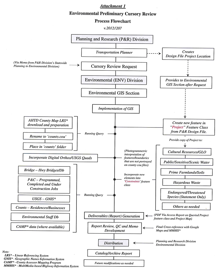 Environmental Preliminary Cursory Review Process Flowchart Description
This figure is a flowchart of the organizations, staff and steps involved to conduct the Arkansas' Environmental Preliminary Cursory Review process.
The process begins in the Planning and Research (P&R) Division, where the Transportation Planner creates the Design File Project Location, and shares the P&R Design File with appropriate staff to support reviews.
The Transportation Planner makes a Cursory Review Request to the Environmental (ENV) Division so its Environmental GIS Section will implement GIS to add information to the Design File. The GIS Section runs queries and adds information to the Design File, including data from: AHTD Country Map Linear Referencing System; Highway Bridges Database; Programmed, Completed and Under Constructions Jobs;USGS Geographic Names Information System; Residence and Business counts; Environmental Staff Database, and County Assessor Mapping Program.
A PDF via Access report on the queried project feature class and project map are generated. The report is reviewed and quality-controlled by cross-referencing it with Google Maps and the MultiMedia-based Highway Information System. A memo is developed and distributed to the P&R and ENV Divisions. The report is cataloged and archived, with future modifications made as needed.
Attachment 2: Report Attributes Associated with Individual Project Feature
Constraints Listing
The following attributes will outline the information that can be forwarded to individuals when cursory reviews are requested. The only information that the Environmental GIS Section will require is a delineation of the project area. When possible, the GIS compiler will indicate specifics on general location of potential constraints and provide a map of the constraint area.
General Information
Job: AHTD Job Number if assigned
Job Name: Unique name to query the specific feature
Job Name Common: Unique name for all features within this review
Date: Month, Day, Year
Date of Base Data: yyyymmdd
Requestor:
Requestor Title:
Requestor Section/Division:
Requestor Phone:
Surveys Contact:
Surveys Phone:
Planning Contact
Planning Phone:
Env Project Manager: Primary Writer of Project
Env Project Manager Phone:
Env GIS Compiler:
Env GIS Phone:
Date Compiled:
Env GPS Compiler:
Env GPS Phone:
Env GPS Compiled:
Env Archeologist:
Env Archeologist Phone:
Env 404:
Env 404 Phone:
Type Project: Environmental Cursory Review
Physical Description: Compiled information from final analysis
Latitude Begin: dd:mm:ss
Longitude Begin: dd:mm:ss
Latitude End: dd:mm:ss
Longitude End: dd:mm:ss
Project Length: miles, kilometers, feet
Project Area: square miles, acres, hectares
Municipal Area Affected: x acres, x hectares, x sq. miles
Comments:
Quadrangle/DOQQ Coverage: Quadname (production date-year)
Counties Within Project Area: Query against P&R Data for counties - Include: Name, Number, Population 1990-2010, and Density
Cities Within Project Area: Query against P&R Data for cities - Include: Name, County, Incorporation Status, Recent Population, FIPS, and if Seat
AHTD Bridges: Query against Bridge Division Data - Include: Bridge Number, Feature Intersected, Year Built, Historic Eligibility, Deck Length, and Type of Construction
Possible Constraints or Concerns Within Project Area
Historical Constraints
Natural Heritage Statement
Soils Prime Farmland
Soils Hydric
Census Statement
Hazardous Waste
Residences
Businesses
Churches
Cemeteries
Schools
Hospitals
Fire Stations
Apartments
Police Stations
Manufactured Home
Airports, Municipal
Airstrip
Railroads
Water Tower
Antenna Mast
Quarry
Racetrack
Major Water
Wetlands
Ditches
Springs
Industry
Parks, City
Parks, State
WMA
Utilities
Minor Water
Other
Comments
Note 1. All GNIS data are displayed by scale at 1:200,000.
Note 2. Some information will be duplicated and may be slightly offset when both feature classes of county and GNIS are displayed concurrently. This offset may also be exhibited when using information that is collected from other outside sources. When this occurs, data that is created by the source agency will be used (i.e., Wildlife Management Areas (WMA) that is created by the Arkansas Game and Fish Commission (AGFC) will be used in lieu of information from the AHTD).
Note 3. Corridor queries will only return those elements that are either within or are touching the actual lines of the corridor or study area delineation. This should be considered when establishing preliminary corridor widths since actual limits of construction may not be available.
Attachment 3: Types and Sources of Data
In order to create a more refined unit of data for the design and development of a constraints database for GIS applications, a variety of information is downloaded from GeoStor at the Arkansas Geographic Information Office (AGIO). There is currently a program that has been initiated between the Environmental Division's GIS Section and the AGIO office to allow real-time pipelining of information into any future projects that require GIS to be used. Until that project is complete and all caveats are dealt with, an alternative procedure that involves downloading specific data from the GeoStor site to the AHTD Servers is currently underway. Those data will basically be a snapshot in time and will have to be periodically updated; therefore, biennial or quarterly downloads to GeoStor for those data will have to be managed. All data downloaded will be used in its native form and will be downloaded in the form of Shapefiles for multiple users around AHTD. All these data will be created and posted in UTM 83. The following data layers are included:
EPA Regulated Facilities (EPA)
Electric Providers (Energy Information Agency)
Emergency Medical Services (ADOH)
FM Station Towers (FCC)
Federal Reservations (USGS DLG 100K)
Four-Year Universities (ADHE)
Health Units (ADOH)
Hospitals (ADOH)
Hydrologic Basins - 8 digit (NRCS)
Intermodal Shipping Terminals (Bureau of Transportation Statistics)
Military Bases (Bureau of Transportation Statistics)
National Park Boundaries (Bureau of Transportation Statistics)
National Scenic Areas - 100K (USGS)
National Wildlife Refuges - 100K (USGS)
Natural Resource Inventory Areas (NRCS)
Private Schools (DOE)
Public Health Regions (ADOH)
Public Schools (ADOH)
Public Schools, K-12 (ADOH)
Rural Health Clinics (ADOH)
Soil and Water Conservation Districts (NRCS)
State Forests or Grasslands - 100K (USGS DLG)
State Parks - 100K (USGS DLG)
State Reservations - 100K (USGS DLG)
State WMAs (AGFC)
State Wildlife Refuges - 100K (USGS DLG)
Technical Colleges (ADOH)
Television Station Towers (FCC)
Wetlands (National Wetlands Inventory)