


September 26, 2019
Innovation of the Month:
Focus on Reducing Rural Roadway Departures
Over the last few weeks, we have discussed the four pillars of the focus on reducing rural roadway departures (FoRRRwD) initiative—addressing roadway departures on all public roads, using systemic safety analysis to identify those locations most at risk, developing safety action plans, and implementing proven roadway departure countermeasures.
This week, we showcase Washington State, who worked with its local agencies to use all four pillars of FoRRRwD to effectively prevent lane departure crashes.
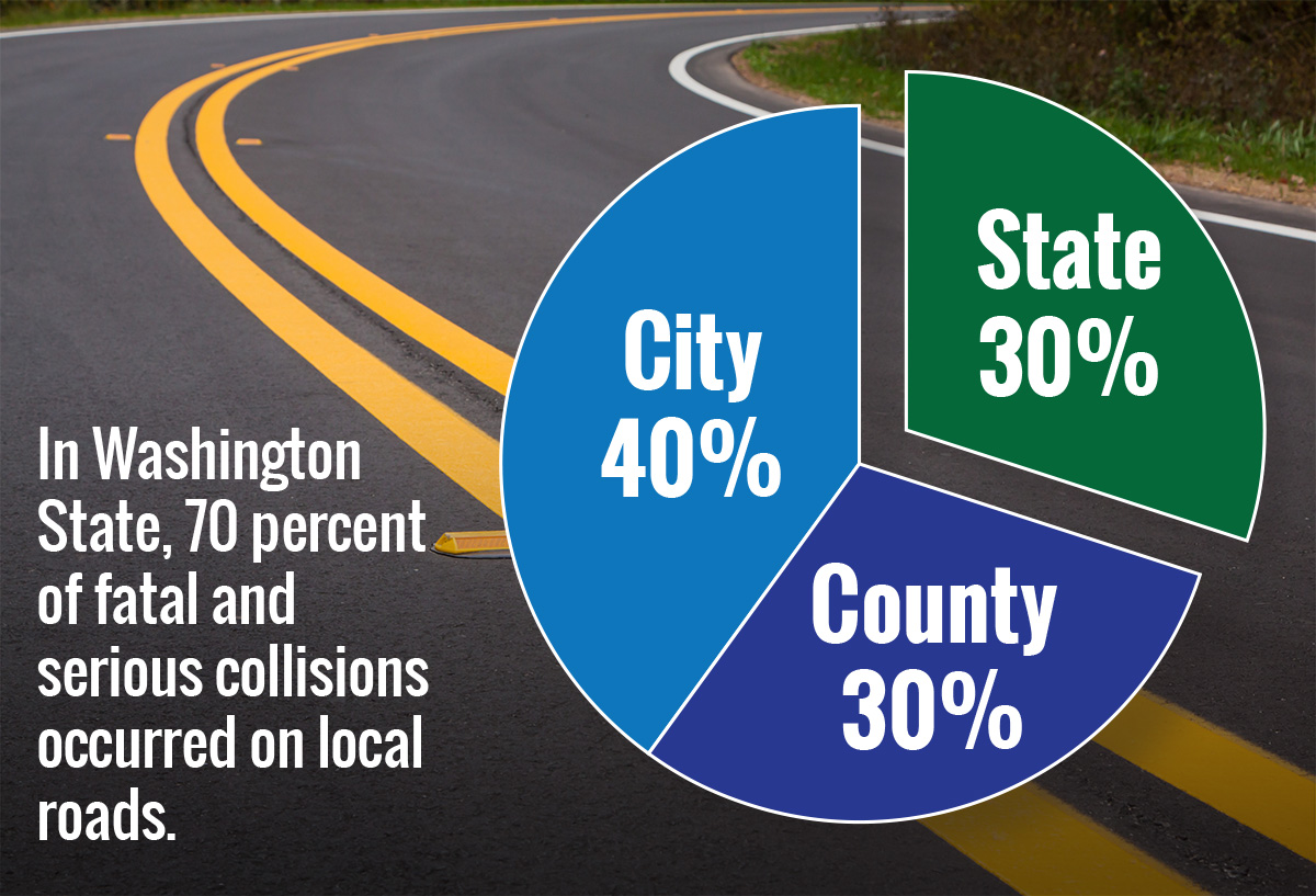
The State evaluated the location of fatal and serious collisions, and dedicated 70 percent of their Highway Safety Improvement Program (HSIP) funding to local agency projects—putting the money where the problems were.
The State conducted initial data analysis and provided information to county engineers for their own county-level systemic analysis. The crash and roadway data allowed each county to easily compare itself to similar counties based on a number of risk factors. Thirty-five of 39 counties completed local road safety plans (LRSPs) to establish priorities and qualify for HSIP funding.
In Thurston County, where about two-thirds of the roads are in rural areas, officials used systemic analysis and its LRSP to target horizontal curves. These curves accounted for 45 percent of the county's fatal and serious injury crashes from 2006 to 2010. With HSIP funding, Thurston County implemented curve safety countermeasures such as enhanced signing, raised pavement markers, rumble strips, and guardrail delineation.
As a result, fatal and serious injury crashes on horizontal curves in Thurston County decreased by 35 percent from 2012 to 2016.
To learn more about how Washington State significantly reduced roadway departures, contact Cate Satterfield with the FHWA Office of Safety or Dick Albin with the FHWA Resource Center.
MDOT Incorporates 2D Modeling Into Hydraulic Analysis
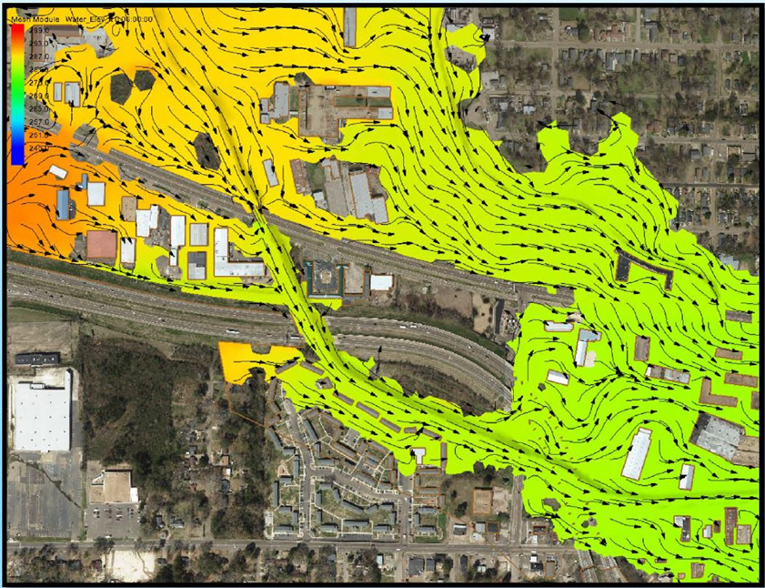
The Mississippi Department of Transportation (MDOT) is seeing the value of incorporating 2D hydraulic modeling into its hydraulic analyses. 2D modeling improves the understanding of the complex interactions between waterways and transportation assets. MDOT used 2D modeling to analyze a particularly complicated project on Lynch Creek in Jackson, MS.
The Lynch Creek project included frequent changes involving land coverage, terrain, and flow direction. The modeling had to accommodate merging floodplains, multiple hydraulic structures, and skewed flow.
In this case, 2D modeling accommodated the complexity and frequent changes at the location by capturing and visualizing the site conditions with a level of detail that couldn't be conveyed through 1D modeling. Using a 1D approach with a series of cross sections would have proven highly impractical to model the complex conditions and would have required many assumptions.
The 2D models also offered MDOT superior options for presenting results to the general public and other project stakeholders. With Lynch Creek, 1D modeling would have provided results only where cross sections were placed, while 2D modeling provided results over the entire project area and could be rendered in an easily interpreted, visual format. The images showed detailed water flow paths, elevation, and velocity.
For more information on MDOT's 2D hydraulic modeling efforts, please contact Mandy Farmer with MDOT. To learn how your agency can incorporate 2D hydraulic modeling, please contact Scott Hogan or Laura Girard with the FHWA Resource Center.
In Case You Missed It – Preview the New and Improved Innovator
Starting with the November/December issue, Innovator will be on a new web platform, accessible from any device.
Until the official launch, we invite you to have a sneak peek with the current issue! Click here to view Innovator on the new platform.

In this issue:
- Moving FoRRRwD to Reduce Rural Roadway Departures
- States STEP Up to Enhance Pedestrian Safety
- Using Data to Improve Traffic Incident Management
- And more…
Comments? Questions? We'd love your feedback! Drop us a line and let us know what you think.
About EDC
Every Day Counts, a State-based program of the Federal Highway Administration’s Center for Accelerating Innovation, works with State, local, and private sector partners to encourage the adoption of proven technologies and innovations to shorten and enhance project delivery.