


October 8, 2020
Innovation of the Month:
Advanced Geotechnical Methods in Exploration (A-GaME)
Last week, we re-introduced Advanced Geotechnical Methods in Exploration, a toolbox approach to subsurface exploration using proven, but underused methods. Using complimentary approaches that consider site conditions and project objectives can provide better site characterization. This can lead to solutions for problems engineers didn’t even know existed, like in this case from Arkansas.
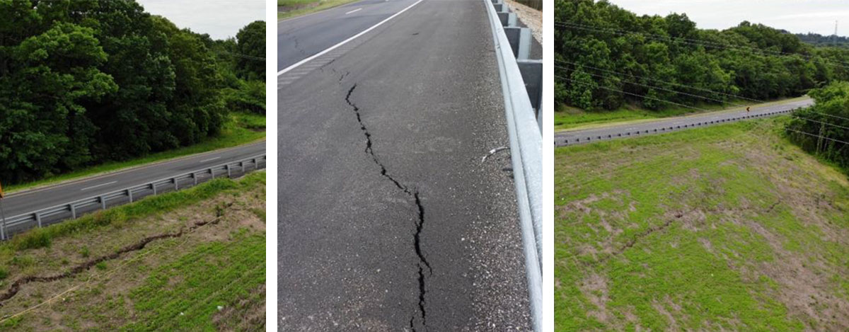
The Arkansas Department of Transportation (ARDOT) implemented several geophysical methods in its subsurface investigation to address slope stability issues along a roadway northwest of Ozark. Over the last 40 years, one section of the highway has experienced settlement and stability issues. Periodic repair efforts including changes in the drainage system and material replacement at the landslide toe often provided temporary relief only. In 2018, a major stabilization effort involving installation of 100 soil/rock anchors and horizontal drainage at the top of the landslide was completed but despite this remediation, additional movements and cracking of the pavement and the slope were observed a year after the repair.
Because drilling and sampling alone had failed to provide a complete picture of the subsurface conditions influencing the landslide, ARDOT conducted further investigations. These included multichannel analysis of surface wave (MASW)/P-wave seismic refraction measurements, microtremor horizontal to vertical spectral ratio (MHVSR) measurements, and electrical resistivity testing.
While the test results generally matched the information available from previous borings, the measurements indicated bowl or hump features within impermeable rock at the landslide toe, and that water being trapped within these bowl features was playing a key role in the slope instability. The bedrock depressions corresponded well to several spring locations observed during field measurements, providing further evidence that the slope instability could be related to groundwater and drainage impedance.
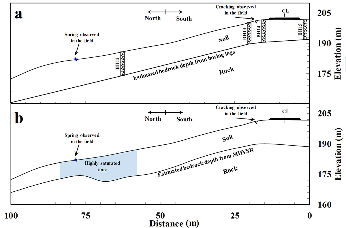
The variation of bedrock elevation and presence of these bowls had not been detected from the limited point-specific data provided by borings alone. Missing features like these or not adequately characterizing them during the investigation can lead to poor interpretations about a landslide's primary driving forces and ultimately result in stabilization efforts that are not successful. The 2018 slope repair cost more than $2.3 million, while geophysical testing for the project would have represented only 2-5 percent of that cost. While this slope repair reduced the rate of the slope movement and likely prevented a global slope failure, it didn't resolve the long-term stability issues. This case illustrates how more effective site characterization using A-GaME technologies can allow better understanding of actual conditions toward better solutions.
If you have additional questions about these proven, innovative geotechnical methods, please contact Ben Rivers of the FHWA Resource Center or Silas Nichols of the FHWA Office of Infrastructure.
Agencies Reduce Impact of Non-Winter Weather Events with WRMS
Agencies across the country are using weather responsive management strategies (WRMS) for a variety of flooding events, dust storms, and wildfires. Wildfires in particular result in burn scars that are at a higher risk for debris flow, erosion, and flooding. The impacts of these weather events lead to an increased risk of speed variance, major roadway infrastructure damage, and vehicular crashes. Here are several examples of how agencies are mitigating these risks through WRMS:
- Flood Management. Delaware DOT is actively working to better monitor and predict flooding using a robust Road Weather Information System (RWIS) network and a fleet of vehicles equipped with mobile environmental station sensors (ESS) and dash cams. Nine unmanned aerial systems are available to the Transportation Management Center for flood response, according to the severity of the event as defined in the event management plan.
- Dust Detection. Arizona is implementing a dust detection system that includes 11 sensors on a 10-mile corridor of I-10. The system automatically activates Variable Speed Limits (VSLs) when and where needed, as the affected area is sometimes only two miles long. The VSLs will lower the speed limit in 10 mile per hour (mph) increments and automatic ramp closures will occur when 35 mph speeds are reached.
- Wildfires and Resulting Burn Scars. California is using new RWIS, mobile RWIS, and collaboration with the National Weather Service, law enforcement and local agencies to assemble forecast information and proactively close highways when mudslides are predicted. Caltrans intends to expand burn scar management efforts to other predicted weather events, such as winter weather and preparing for wildfires.
For additional WRMS information and publications, check out the WRMS Toolkit. To learn more about how you can implement WRMS in your agency, contact David Johnson, team lead for WRMS.
EDC Outtakes – A-GaME
EDC Outtakes–a series of short interview videos–State practitioners and FHWA personnel give insight into the current round of EDC innovations. In our latest edition, Derrick Dasenbrock, A-GaME team member, discusses A-GaME, some of its benefits, and some of the tools used in this toolbox approach.
Keep reading EDC News for future editions of EDC Outtakes!
About EDC
Every Day Counts, a State-based program of the Federal Highway Administration’s Center for Accelerating Innovation, works with State, local, and private sector partners to encourage the adoption of proven technologies and innovations to shorten and enhance project delivery.