


September 30, 2021
EDC Synergy:
Unmanned Aerial Systems and Advanced Geotechnical Methods in Exploration
Planning a geotechnical site characterization program for a transportation project begins with recognizing project requirements and anticipating subsurface conditions. Before advancing the first Cone Penetration Test, test-boring, or running the first Seismic Refraction or Electrical Resistivity line, all parts of the Advanced Geotechnical Methods in Exploration (A-GaME) toolbox, geotechnical engineers need to examine existing site information and conduct site-reconnaissance. With the aid of Unmanned aerial systems (UAS) to gather imagery and data for improved mapping and characterization of surface features, geotechnical engineers are better informed during site characterization. State DOTs can use data routinely collected by state geological surveys, like the images shown here from the Kentucky Geological Survey.
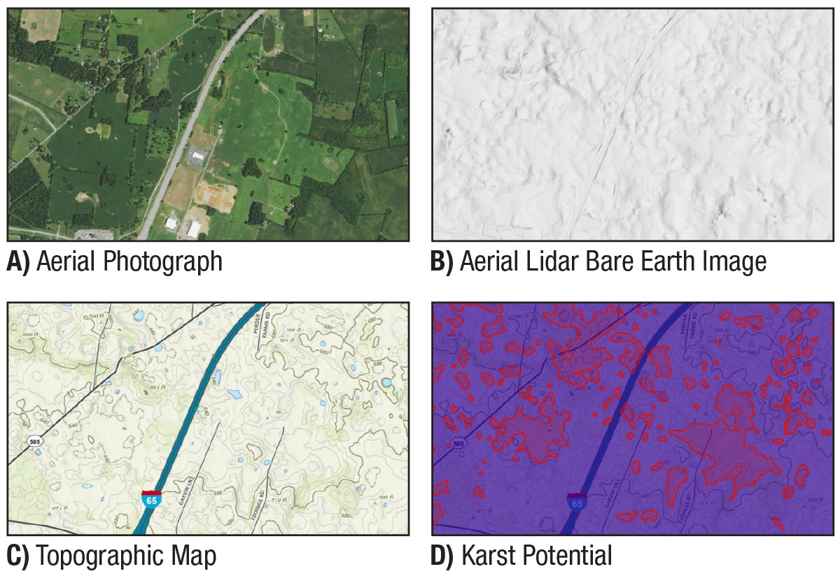
Aerial images captured using UAS can be integrated with other geospatial data to inform decisions on roadway alignments and improvements and to identify areas where subsurface investigation efforts should be focused. For example, areas showing vegetation growth are tell-tale signs of near-surface groundwater impacting dissolvable rock. Likewise, depressed areas and surface sink-hole expressions caused by dissolved rock are easily seen in aerial light detection and ranging (LiDAR) bare-earth rendering. By comparing available LiDAR imaging from State Geological Surveys to LiDAR imaging obtained by UAS at any time, recent subsidence from dissolving rock can be identified. So, by incorporating UAS aerial imaging and geologic mapping, a large part of the site characterization planning process is now at the geotechnical engineer’s fingertips.
To learn more about UAS, please contact James Gray, FHWA Office of Infrastructure. To learn more about the A-GaME, please contact Ben Rivers, FHWA Resource Center.
Joint Development Project Supports Revitalization Without Raising City Taxes in Maine
In Biddeford, ME, a joint development project incorporated the design, build, finance, operation and maintenance of a 640-space parking garage; completed the city’s urban RiverWalk; and improved pedestrian connections. The project accomplished all of this without using residential property tax dollars or impacting the city’s tax rate. The city will contribute annual funding from tax increment financing revenues and parking fees. The agreement also allows revenue sharing with the city if parking revenues exceed forecasts. The City of Biddeford expects construction of the garage to provide over $16 million in additional property taxes in the first 10 years of operation and a net benefit of nearly $40 million over the next 25 years. The project is part of Biddeford’s revitalization plan for its downtown Mill District and will also support two other nearby redevelopment projects.
To learn more about this project or others using value capture techniques, please contact Thay Bishop or Stefan Natzke, value capture team co-leads.
Georgia DOT Celebrates Three Decades Using Stone Matrix Asphalt
Stone matrix asphalt (SMA) marks three decades of use in the U.S. this year. While it has been used in at least 40 States, only 18 departments of transportation (DOTs) use it routinely. FHWA is promoting SMA as one of 12 Targeted Overlay Pavement Solutions (TOPS) under EDC-6. Georgia DOT was one of the first agencies that used information from a European Asphalt Study Tour to design and place SMA test sections in 1991. After several years of research, evaluation of early project performance, and review of European experiences, GDOT found SMA mixtures to be more rut resistant, had longer fatigue lives, and had longer service lives than conventional dense-graded mixtures. As a result, GDOT expanded SMA use to all interstate projects and State routes with an average daily traffic volume of 50,000. Since the first test section in 1991, over 4.4 million tons of SMA have been placed on more than 133 projects in Georgia.
One of the first full-scale SMA projects constructed in 1994 was on I-95 in Chatham County near Georgia’s coastline. This stretch of interstate carried approximately 72,000 vehicles per day, with 28.5 percent of that being truck traffic. Though the surface layer placed on this interstate route was replaced after 15 years, the SMA layer underneath is still performing well after more than 25 years of service.
To learn more about SMA or other overlays in the TOPS toolkit, please contact Tim Aschenbrener, FHWA Office of Preconstruction, Construction, and Pavements.
Building Information Modeling Practices Study Report Now Available
The FHWA Office of International Programs has released the Global Benchmarking Program study report on Building Information Modeling (BIM) Practices in Highways.
Once considered just for buildings, BIM is gaining rapid acceptance in several infrastructure industries, including highway transportation. BIM for highway infrastructure is a transformative approach of connecting data so that it is readily and reliably available across life-cycle phases of built infrastructure. BIM practices have been reflected in EDC initiatives including 3D Modeling, e-Construction, e-Ticketing and Digital As-Builts.
This study documents evolving trends in BIM-mature nations and their public highway infrastructure agencies, with a focus on the areas of leadership, BIM framework, communication and implementation.
To learn more about BIM for Infrastructure, please contact Katherine Petros, FHWA Office of Research, Development and Technology, or David Unkefer, FHWA Resource Center. For more information about the Global Benchmarking Program, contact Hana Maier, FHWA International Programs Office.
Stay Up to Date on the EDC Innovations That Interest You Most

EDC teams are always on the move! If you blink, you could miss out on important webinars, case studies, tools, videos, and more. To never miss information for the EDC innovations that interest you most, visit the subscription page and select the topics you’d like to receive updates on directly from the teams that coordinate them.
Recent bulletins:
A-GaME – 9/20/21
Project Bundling – 9/15/21
Virtual Public Involvement – 9/14/21
Local Aid Support – 9/13/21
A-GaME – 9/1/21
About EDC
Every Day Counts, a state-based initiative of the Federal Highway Administration's Center for Accelerating Innovation, works with state, local and private sector partners to encourage the adoption of proven technologies and innovations to shorten and enhance project delivery.
EDC News is published weekly by the FHWA Center for Accelerating Innovation.
Recommended Citation:
U.S. Department of Transportation, Federal Highway Administration Every Day Counts: Innovation for a Nation on the Move
EDC News: September 30, 2021
Washington, DC:
https://doi.org/10.21949/1521814