U.S. Department of Transportation
Federal Highway Administration
1200 New Jersey Avenue, SE
Washington, DC 20590
202-366-4000
Transportation agencies often struggle with how to effectively engage with and inform the public about upcoming projects and capture vital feedback. Many engagement efforts experience low participation and have difficulty capturing diverse viewpoints from a variety of communities. There may also be language and cultural barriers or scheduling conflicts that prevent people from attending meetings in person.
"The public's expectations of how we, as agencies, interact with them is ever changing," said Lana Lau, FHWA's virtual public involvement (VPI) team co-leader. "This doesn't mean the public isn't interested in participating. It just means we need to be more innovative and thoughtful in our approach."
FHWA's VPI initiative, an Every Day Counts (EDC) innovation, encourages the use of digital technology and innovative strategies to make it easier and more convenient for people to participate in the transportation decision-making process.
VPI tools and techniques supplement face-to-face information sharing. They do not replace the need for in-person meetings, nor do they change existing public information requirements established by law.
As part of EDC round 5, FHWA met its goal to help 38 States expand use of VPI tools and techniques. FHWA also created a VPI web page that features an innovation overview video, fact sheets, case study videos, and reports highlighting key outcomes of workshops and peer exchanges.
A focus of EDC round 6 (EDC-6) will be encouraging States to institutionalize the use of VPI tools as a regular way of doing business. FHWA considers a State department of transportation (DOT) to have institutionalized VPI if its program does the following:
"Another goal for EDC-6 is to increase public participation for traditionally underserved communities such as minorities, low income, children, elderly, and the disabled," said Jill Stark, FHWA VPI team co-leader. "We also plan to reach out beyond the State DOTs to provide technical assistance to metropolitan planning organizations, rural transportation planning organizations, and tribal governments."
North Carolina DOT's use of all-in-one tools significantly increased the number of participants providing project input. Participants were able to better understand projects, participate at convenient times, and provide detailed feedback.
Credit: North Carolina DOT
There are many potential benefits to using VPI, such as improved communication and collaboration with stakeholders. Virtual tools and platforms can be made accessible to communities efficiently, many at a lower cost than traditional public involvement methods. Another benefit is accelerated project delivery. When agencies effectively engage the public in the beginning of a project, it helps identify issues early, reducing the need to revisit decisions later.
The VPI team is promoting eight categories of tools during EDC-6 and may add more as new technology is developed.
Mobile applications, such as the app created by the Delaware DOT, can include information about meetings and workshops, construction projects, transit services, electronic vehicle charging station locations, and more.
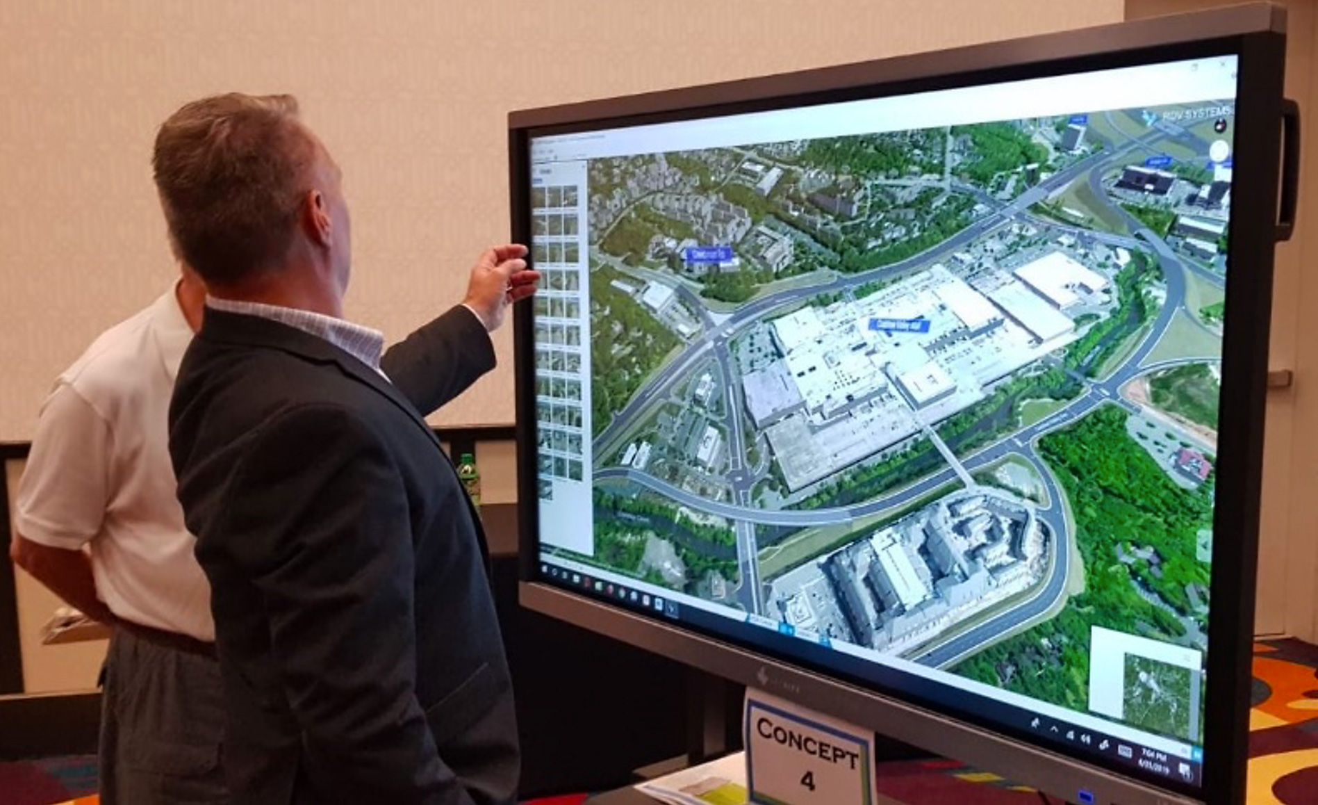
Project visualization involves the creation of images, diagrams, or animations to communicate a message. The Visual Engineering Resource Group at Washington State DOT develops visualizations to support the department's project development processes. A combination of 3D modeling, videos, photos, and animations is used to give the public a clearer idea of how a project may affect them. Agencies can adjust visualizations simultaneously as they receive feedback at a public meeting.
Digital tools can be used to enhance in-person events.
Credit: North Carolina DOT
Mapping tools allow information to be communicated visually, making it easier for the public to digest complicated data in a concise, clear format.
Do-it-yourself videos are an engaging way to communicate with the public, especially since smartphones and other relatively inexpensive recording devices are readily available.
Crowdsourcing tools are digital tools, both online and mobile, used to assemble ideas, comments, or suggestions and provide a forum for others to assess the value of those suggestions by voting for or against them.
Online meetings enable interactive aspects such as mapping and survey tools people can explore and use at their own pace.
All-in-one tools have been developed by several software companies to combine crowdsourcing features, mapping, visualization, file storage, and survey instruments. North Carolina DOT found that using all-in-one tools significantly increased the number of participants providing input on projects, and that many barriers to participation disappeared.
Digital tools for in-person events may include techniques such as live polling to enhance the public meeting experience. Staff can engage with participants at meetings and display responses in real time.
See FHWA's VPI web page for case studies, webinars, and lessons learned.
Watch a VPI overview video.
Apply for funding to help implement VPI techniques.
Contact Jill Stark of the FHWA Office of Planning, Stewardship & Oversight, or Lana Lau and Carolyn Nelson of the FHWA Office of Project Development & Environmental Review, for more information and technical assistance.
Crossing the road doesn't have to be deadly. But in 2018, it was for 6,283 pedestrians. That's one death every 84 minutes.
What can be done?
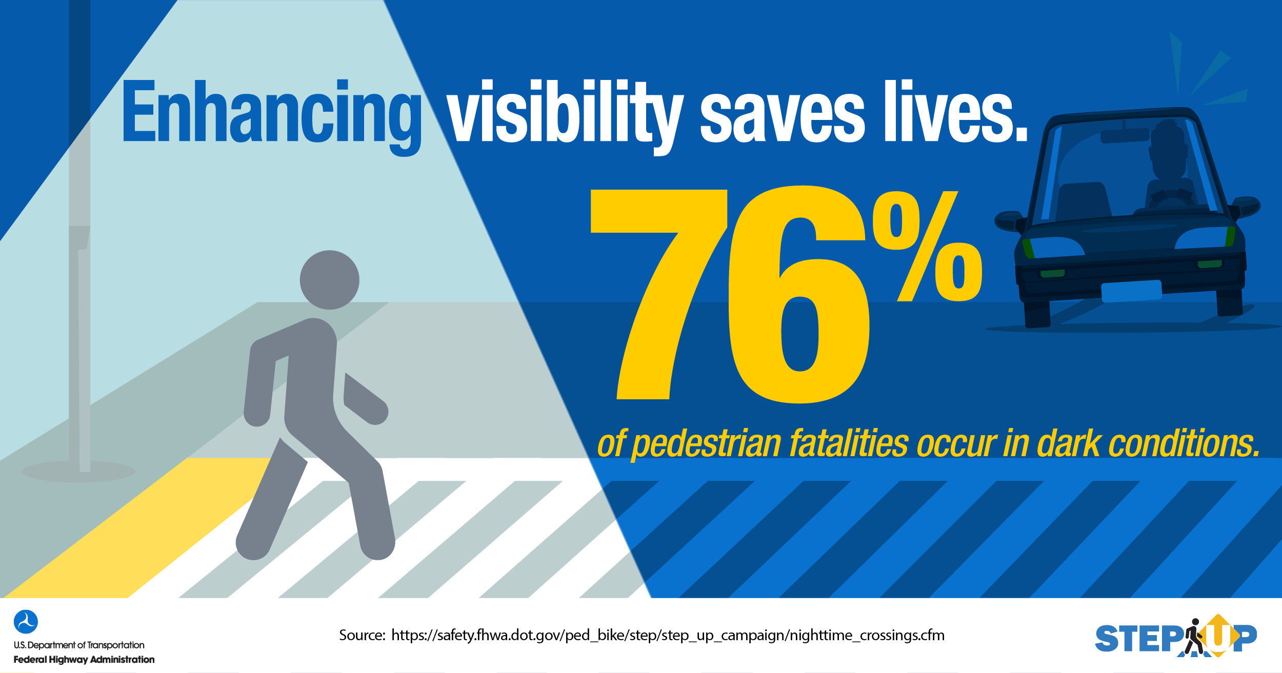
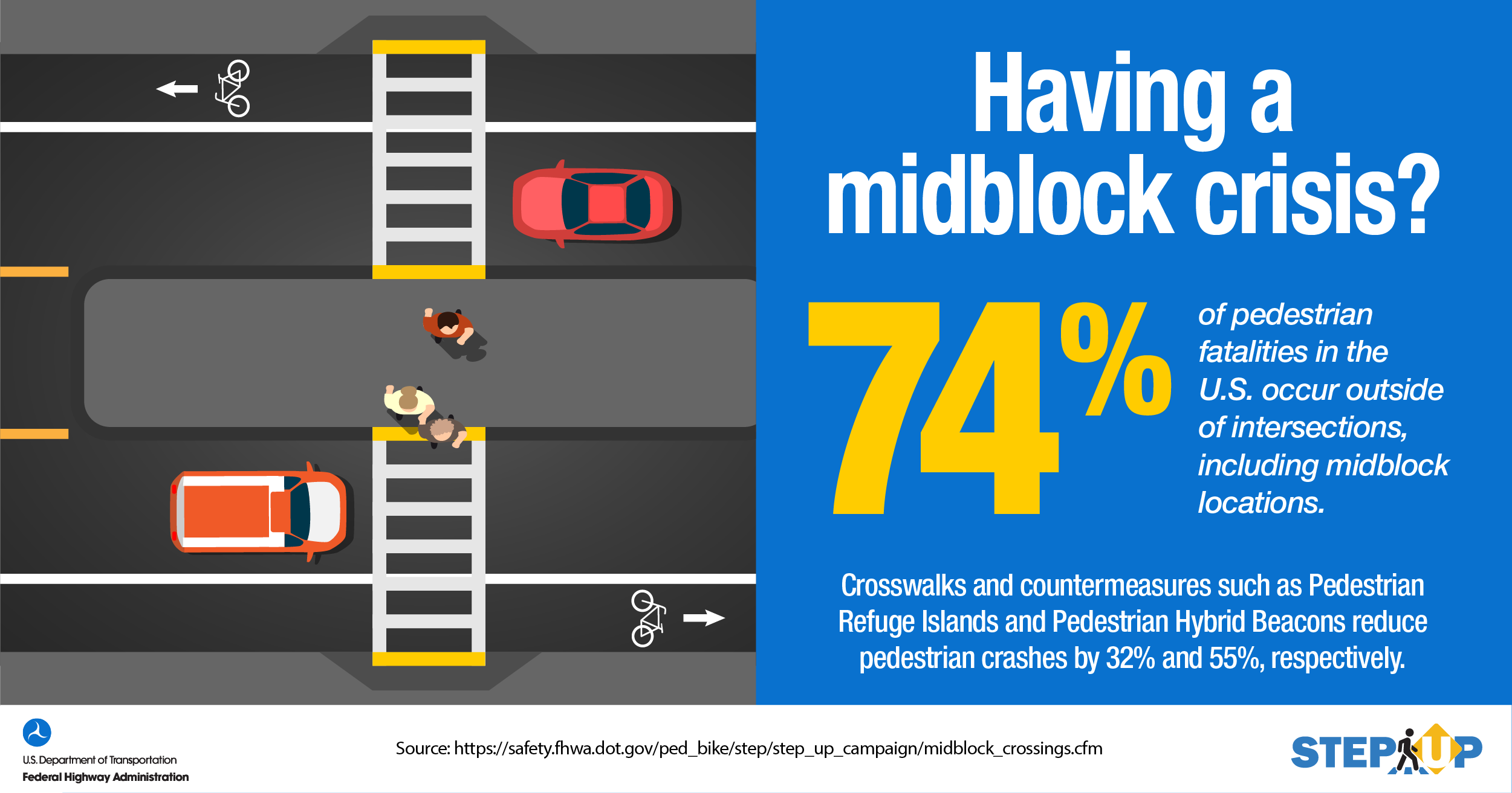
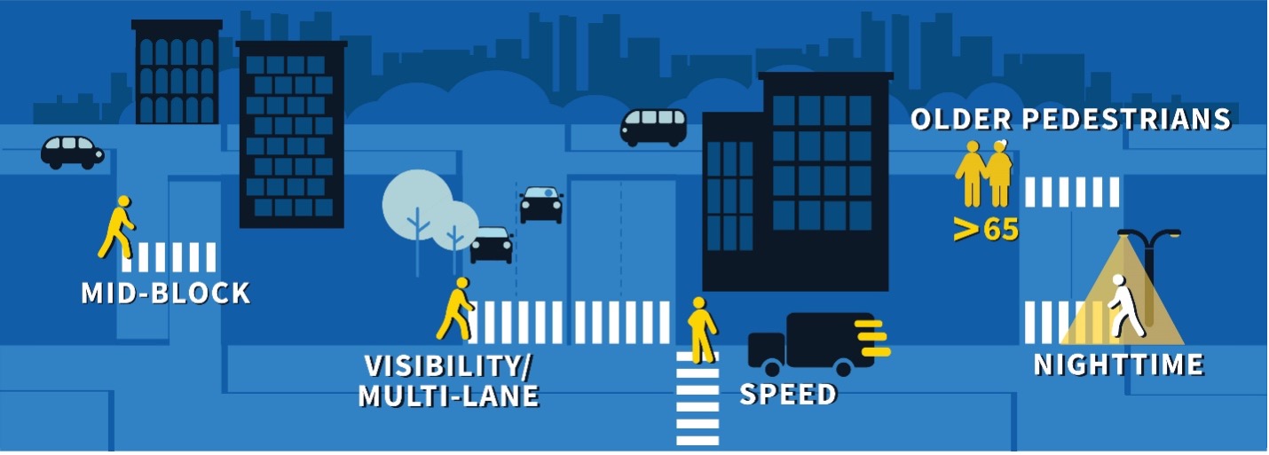
The FHWA Safe Transportation for Every Pedestrian (STEP) program promotes strategies and countermeasures proven to reduce severe pedestrian crashes. The countermeasures protect pedestrians when and where they are most vulnerable while crossing the street. The program focuses on key safety issues where pedestrians are more at risk for being killed in a crash: nighttime, between intersections, older pedestrians, higher speeds, and multi-lane crossings. Most pedestrian fatalities occur in these conditions.
Statistics show these vulnerabilities and provide focus areas where the countermeasures will help solve the biggest problems. For instance, in 2018, 74 percent of pedestrian fatalities nationwide occurred between intersections and 76 percent of U.S. pedestrian fatalities occurred in dark conditions. Vehicle speed is a deciding factor in most pedestrian fatalities. If a pedestrian is struck by a vehicle traveling at 25 mph, there is an estimated 10-percent chance of serious or fatal injury. When hit at 40 mph, there is a 75 percent chance of serious or fatal pedestrian injury.
"The data is clear," said Becky Crowe, FHWA STEP program co-lead. "We want to help agencies focus on the most dangerous situations for people walking, and our STEP countermeasures offer solutions for these high-risk areas."
The seven countermeasures promoted by STEP are proven to improve safety under these high-risk conditions. Often, these countermeasures can be used in combination to reduce multiple risks at pedestrian crossings. Rectangular rapid-flashing beacons are often paired with pedestrian refuge islands, and leading pedestrian intervals work well with crosswalk visibility markings such as curb extensions to enhance visibility of the pedestrian in the crosswalk. STEP has produced tech sheets for each of the Spectacular Seven countermeasures and has documented their success in over 30 case studies.
Credit: FHWA
Crosswalk visibility enhancements are a group of countermeasures including improved lighting, advance or in-street warning signs, high-visibility pavement markings, and geometric design elements that work together to make pedestrians more visible in crosswalks. These cross-cutting measures address most of the STEP focus areas.
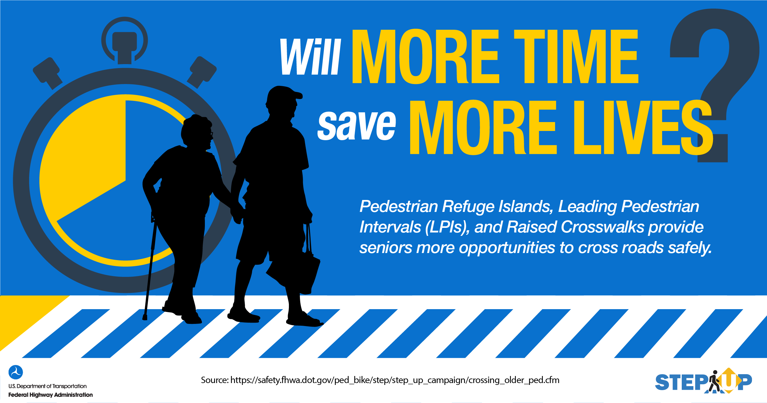
Leading pedestrian intervals are adjustments to signal timing to increase pedestrian safety at signalized intersections. This is especially helpful for older pedestrians, who may need more time to cross.
Pedestrian hybrid beacon (PHB) heads consist of two red lenses above a single yellow lens. Unlike a traffic signal, the PHB rests in dark until a pedestrian activates it. When activated, PHBs stop all lanes of traffic. They are especially helpful at midblock and multi-lane crossings.
Pedestrian refuge islands are medians with a "refuge" area in the middle to help protect pedestrians crossing single- or multi-lane roads. They can be used at midblock or intersections and let pedestrians focus on crossing one direction of traffic at a time. This is helpful for all pedestrians, but older ones in particular.
Credit: FHWA
Raised crosswalks are ramped speed tables spanning the entire width of the roadway, often at midblock. They are flush with the height of the sidewalk, which slows vehicles and makes it easier for pedestrians to cross, including the elderly.
Road diets typically convert an existing four-lane, undivided roadway to two through lanes and a center, two-way left turn lane. They reduce crossing distance and exposure for pedestrians, as well as vehicle speed.
Credit: FHWA
Rectangular rapid-flashing beacons are pedestrian-actuated, attention-getting LED beacons that alert drivers to pedestrians who want to cross. They are used in combination with advance warning signs to improve safety at uncontrolled, marked crosswalks.
The Spectacular Seven countermeasures increase driver yielding at crosswalks, slow vehicle speeds, control traffic and reduce conflicts between vehicles and pedestrians, and improve visibility where people are likely to cross the road. These safety outcomes are in line with the Safe System Approach—a holistic view of roadway safety that promotes, among other strategies, the role of infrastructure in eliminating traffic fatalities. The approach assumes humans make mistakes, but that infrastructure can anticipate those mistakes and ensure they are not fatal. When these countermeasures are used in tandem, across the system, and in combination with other strategies, risk of pedestrian fatalities can be reduced.
Credit: FHWA
"STEP and the Safe System Approach are a natural fit," said Peter Eun, FHWA STEP program co-lead. "More and more, people want multiple mobility options. That means broadening our view of how everyone interacts with their infrastructure so they can travel safely, no matter the mode."
More than ever, crossing the road doesn't have to be deadly.
View STEP videos and a storyboard that explain the benefits of the Spectacular Seven countermeasures.
Visit the STEP webpage for resources, webinars, and videos to aid STEP deployment.
Check out the EDC-5 Final Report to see progress made by States in implementing STEP.
Contact Becky Crowe of the FHWA Office of Safety or Peter Eun of the FHWA Resource Center for information and technical assistance.
Vermont's transportation system includes a substantial inventory of bridges ranging in age from 40 to 90 years, many of which are nearing the end of their useful lives. Due to its mountainous topography, the State faces additional challenges with bridges over winding waterways. Flash flooding from localized storms is not uncommon and, as seen in 2011 during Tropical Storm Irene, its powerful force can quickly undermine bridge foundations and cause devastation if structures are not appropriately designed for scour.
The more sinuous and meandering waterways of Vermont's valleys pose unique challenges for bridge infrastructure. Both the Lake Champlain and Connecticut River drainage basins possess a significant number of bridges that are highly skewed. It was for these valley-based structures that the Vermont Agency of Transportation (VTrans) began considering the advantages of the two-dimensional (2D) hydraulic modeling approach promoted in round five of Every Day Counts (EDC-5). The collaborative hydraulics: advancing to the next generation of engineering (CHANGE) initiative deployed 2D modeling tools that offered an improved understanding of the complex interactions between river environments and transportation assets.
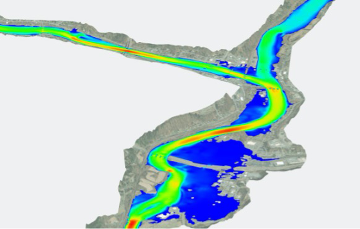
VTrans uses 2D modeling to improve bridge design in areas with complex hydraulics, such as this crossing over the White River, a tributary to the Connecticut River. The model shows flow velocities through the river's reach.
Credit: Vermont Agency of Transportation Background image: ESRI World Imagery
Prior to implementing CHANGE, VTrans staff relied on 1D hydraulic modeling software to analyze and size existing and planned bridge structures. Faced with the challenge of rehabilitating or replacing many of its aging bridges in low-lying valleys, VTrans was struggling with how to adequately inform, with confidence, a 1D model for bridges spanning meandering channels. Because the results of 1D modeling depend greatly on simplified assumptions, it can lead to overestimating or underestimating important results such as water surface elevations, velocities, scour depths, and consequently designed scour countermeasures.
"We understood that 1D models were not providing the results necessary to make sound engineering decisions for the interaction between complex flow patterns and highway infrastructure," said State Hydraulics Engineer Nick Wark. "The 1D approach also made it very difficult for us to convey model results to stakeholders, including our bridge design teams."
In fall 2015, VTrans hydraulics staff had participated in the National Highway Institute (NHI) Two-Dimensional Hydraulic Modeling of Rivers at Highway Encroachments training. Afterward, VTrans attempted to create a fully developed 2D hydraulic model, but the model was never completed due to a lack of intimate software knowledge and troubleshooting experience.
"We recognized that the NHI training outfitted us with the necessary means to get started," said Keith Friedland, a member of the VTrans hydraulics team, "but as with any new tool or piece of equipment, there is always a learning curve after an initial introduction."
In late 2017, VTrans focused on implementing CHANGE and built its first fully successful 2D model. The model used two tools promoted by EDC: Sedimentation and River Hydraulics – Two-Dimension (SRH-2D), a program developed at the U.S. Bureau of Reclamation, and Surface-water Modeling System (SMS) software.
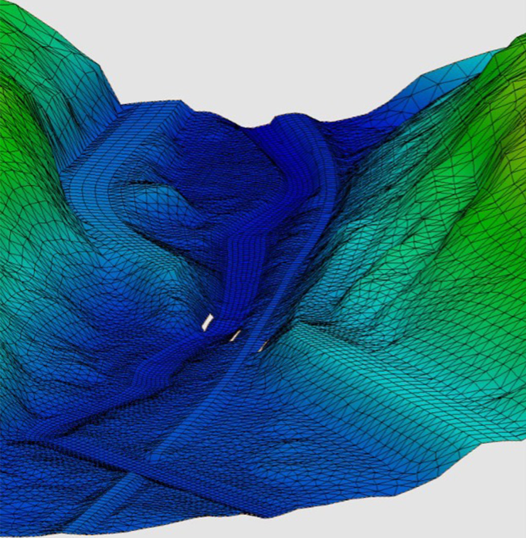
In this VTrans 2D model, the mesh represents terrain at a road crossing of a river and a railroad. The holes in the mesh represent piers. Velocity and depth can be computed at each element within the mesh.
Credit: Vermont Agency of Transportation
After developing the 2D model, staff found themselves with the technical ability to create and run models but with uncertain confidence in the results. "The difficult part was knowing whether the models we were creating were reliable and how to adequately review and verify our models when we were still in a learning phase," said Wark.
Resources available through CHANGE helped guide VTrans through these unanswered questions. The initiative provided access to technical support from the FHWA Resource Center and consultants to review VTrans' work and assist them with technical questions, enabling staff to fine-tune the model parameters and input needed to run efficient hydraulic models. They also received tips for extracting meaningful results. Additional resources VTrans found helpful were FHWA's 2D Hydraulic Modeling User's Forum webinars and online SMS tutorial videos.
"From the support we received through the EDC CHANGE initiative, we gained the skills necessary to develop and review our hydraulic models," said Wark, "but for us to gain confidence, our team needed to continue building models and refine our skills along the way."
Between 2017 and 2019, VTrans built seven 2D models with SRH-2D and SMS. With each new model came increased confidence and model development efficiency. Jeff DeGraff, another member of the VTrans hydraulics team, said "We found that once you have developed 5 to 10 successful 2D models, the modeling process time, from start to finish, is just as fast or even faster than the development of a 1D model."
Today, nearly all programmed bridge design projects in Vermont are developed using 2D hydraulic models. Staff have now created more than 50 models with SRH-2D and SMS. For VTrans, the 2D approach is helping balance many competing demands. It enables the agency to more cost-effectively right-size its bridges while accommodating Vermont's natural landscape, and its unprecedented graphical output supports design and construction of safer and more resilient structures over the State's waterways.
Consult Graphical Visualization Tools for 2D Hydraulic Modeling for details on the tools and software mentioned in this article.
Watch an FHWA video series on best practices for developing accurate and efficient 2D models.
Refer to FHWA's Tech Brief: Overview of Practices for Adopting 2D Hydraulic Modeling and Two-Dimensional Hydraulic Modeling for Highways in the River Environment for overviews of 2D modeling approaches in several States.
Check out the EDC-5 Final Report to see progress made by States in implementing CHANGE.
Contact Scott Hogan or Laura Girard, both of the FHWA Resource Center, for information and technical assistance.

Credit: FHWA
The sixth round of Every Day Counts (EDC-6) kicked off with a Virtual Summit in December 2020 that introduced the seven innovations FHWA is promoting over the next 2 years. The summit also featured a National State Transportation Innovation Council (STIC) Network Showcase that highlighted 245 innovations in six categories developed and deployed by agencies throughout the country. The following are just a few examples of the expertise and ingenuity agencies are putting into action to save lives, time, and money in the areas of safety, planning, and environment.
Many of the homegrown innovations featured in the STIC Network Showcase are aimed at improving safety. The goal of the Missouri Department of Transportation (MoDOT) Buckle Up Phone Down (BUPD) Challenge campaign is to draw attention to and combat distracted driving stemming from cellphone use. MoDOT places videos and graphics on its social media channels and BUPD website encouraging individuals and business to accept the challenge to buckle up and put their phones down while driving.
Another traffic safety problem is wrong-way driving (WWD). WWD crashes tend to be more severe than other types, and highway agencies are working to implement systems to prevent them. The showcase includes WWD initiatives from Arizona, Florida, and Texas.
The Arizona DOT's I-17 pilot proved to be an effective corridor-level system of WWD countermeasures including thermal cameras for detection, dynamic messaging for driver notification, and decision-support software for immediate notification and verification.
The Florida DOT initiative found LED-highlighted wrong-way signs to be one of the most effective countermeasures to warn a wrong-way entering motorist, notify other motorists, and send alerts to transportation management centers. The Central Texas Regional Mobility Authority's pilot project on a newly constructed toll road was designed to detect wrong-way motorists, activate roadside signage to alert drivers, and notify law enforcement.
At the local level, city and county engineers often receive a variety of communications from residents about traffic safety concerns, including requests to install traffic-control measures such as stop signs or warning signs. Minnesota's Local Road Research Board developed a guidebook for Addressing Citizen Requests for Traffic Safety Concerns that provides recommended procedures for evaluating and responding to these requests. The guidebook also reviews various traffic safety devices and their appropriate uses.
Another homegrown innovation focus is planning and environment, which often involves public communication and outreach. The Massachusetts DOT is using the Public Involvement Management Application (PIMA) to manage the full public involvement process on all its projects. PIMA was developed by Iowa DOT in 2015 and is now in use by a consortium of over 15 transportation agencies to meet a variety of public engagement needs.
The Oklahoma DOT saw a significant increase in public responses following use of the U.S. Postal Service Every Door Direct Mail® service, which enables targeted outreach based on census data. The agency was able to provide hard-to-reach communities with the same materials that would have been distributed at a face-to-face meeting.
The Texas DOT used performance-based planning and programming elements to create corridor prioritization and evaluation tools that guide data-based decision-making based on the department's top priority goals. The Nebraska DOT is creating a Nebraska Environmental Documentation System (NEDS) that will provide a web-based ecosystem and an enhanced documentation process for all of its environmental professionals and specialists to complete their reviews, analyses, and documentation.
Register for access to the EDC-6 Virtual Summit on-demand content to learn more and watch presentations about these and other homegrown innovations. After registering, click on the National STIC Network Showcase button.
Nominations are open for the 2021 STIC Excellence Award, which recognizes a STIC that has made significant impact toward fostering a strong culture for innovation. Past awardees have been recognized for a variety of efforts and initiatives, representing agencies from across the Nation that put innovation at the forefront. FHWA's Center for Accelerating Innovation and the American Association of State Highway and Transportation Officials Innovation Initiative partnered to sponsor the award to promote innovations and to recognize excellence within the STICs.
Nominations may be submitted through July 1, 2021. See the 2021 STIC Excellence Award Nomination form for more details and visit the STIC Excellence Award webpage to read about past recipients.
For more than a decade, FHWA's Every Day Counts (EDC) program has promoted proven but underused innovations that enhance roadway safety, improve project delivery, and reduce traffic congestion. Across the country, agencies attest to the value of adopting these new technologies and processes, along with creative strategies for innovation deployment. As the transportation community participates in EDC round six, Innovator is featuring articles that reflect on the program's accomplishments.
Since its inception, EDC has helped identify and promote innovative processes and procedures in the areas of environment and planning. Each successive round of EDC has built a network of connections within FHWA offices and between State departments of transportation (DOTs), local transportation agencies, and Federal and State agencies. These networks allow agencies to align visions and resources toward common goals.
"The EDC environment and planning initiatives successfully brought together Federal, State, local, and other stakeholders to revitalize and improve on existing practices while encouraging cooperation and collaboration among those agencies," said Mike Ruth, FHWA Resource Center. "These efforts have streamlined processes and built relationships across agencies that will continue to pay dividends for years to come."
Programmatic agreements (PAs) can accelerate the process for handling project actions by allowing review at a program level rather than on a project basis. These interagency agreements set procedures for consultation, review, performance, and compliance with one or more Federal laws and also address Tribal, State, and local laws. Using PAs, agencies can increase efficiency, improve predictability, and provide benefits to the environment.
Prior to EDC, PAs were not being widely used due to narrow scopes, change in regulatory frameworks, or lack of awareness. Through EDC, FHWA updated and expanded current practices, incorporating more flexibility to broaden their use. State and regional agreements were an important focus area under EDC-2, particularly with the U.S. Army Corps of Engineers (USACE), the U.S. Fish and Wildlife Service, and the National Marine Fisheries Service.
EDC initiatives directly contributed to expansion of PAs across the country. All 50 States now leverage PAs, with 37 States using two or more to improve project delivery. Across all agency levels, FHWA has over 500 PAs, significantly reducing permit action timelines.
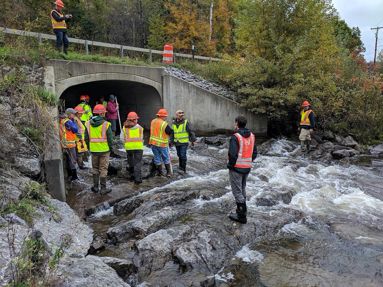
EDC workshop participants from New York State DOT and USACE at a culvert assessment site visit in 2018.
Credit: New York State Department of Transportation
The EDC process helped foster interagency communication and relationship building by bringing together stakeholders to promote strategies, actions, and innovative processes to address current needs.
"In addition to establishing PAs and working toward common interests, agencies have found it effective to establish scheduled informational meetings, promoting candid conversation benefitting all parties. These activities build trust and relationships," said Ruth.
During EDC-1, planning and environment linkages (PEL) brought stakeholders together to consider environmental, community, and economic goals early in transportation planning, then used this information to streamline environmental reviews. This approach provided an opportunity for resource, action, and regulatory agencies to get involved early to help shape the projects.
During EDC-3, regional models of cooperation helped State DOTs, regional planning groups, and other stakeholders coordinate planning across jurisdictional boundaries to support common goals such as safety, congestion management, freight, livability, economic development, and efficient project delivery.
The 2015 Red Book, first published in 1988, functions as a "how to" for synchronizing NEPA and other regulatory reviews. This document originally focused on NEPA and Section 404 of the Clean Water Act, but as a result of EDC, the 2015 version was expanded to include all permitting agencies and leveraged current, more flexible practices. "By building trust and relationships," said Ruth, "EDC expanded the Red Book from boutique to big box store level."
Work in EDC environment and planning initiatives also enabled an integrated approach to other innovations, such as design-build, by bringing in stakeholders and decision makers early in project development.
"The advances made in environmental and planning initiatives throughout EDC wouldn't be possible without the active participation from partner agencies and organizations," said Ruth. "EDC made it possible by bringing these groups together, and the shared desire to do better, be more efficient, and strive toward a common goal helped make that goal a reality."
Efforts in motion today include expanding mitigation opportunities through culvert banking and conducting mitigation on public lands. Culvert banking leverages USACE Regulatory Guidance Letter 18-01, providing an opportunity for DOTs that replace underperforming culverts with aquatic-friendly and resilient designs to generate mitigation credits for projects. This process enables DOTs to satisfy mitigation obligations on Federal lands. FHWA is developing outreach materials for these new approaches.
View PEL Today, an on-demand webinar overview of planning and environment linkages.
Visit the regional models of cooperation website to watch a video or read the handbook.
Check out FHWA's Environmental Review Toolkit to learn more about PAs.
Contact Mike Ruth of the FHWA Resource Center or Owen Lindauer of FHWA's Office of Planning, Environment & Realty for more information on EDC environment and planning innovations.
In EDC Outtakes—a series of short interview videos—transportation professionals provide insights on Every Day Counts innovations. In these editions, Courtney Frisch, public works project manager for the city of Decatur, GA, discusses safety improvements from implementing raised crosswalks, and Brian Mayhew, North Carolina Department of Transportation, discusses rectangular rapid-flashing beacons (RRFBs), their benefits, and some of the additional countermeasures that are deployed with them. Raised crosswalks and RRFBs are two countermeasures promoted by EDC's Safe Transportation for Every Pedestrian (STEP) initiative.
For more deployment highlights from STEP, as well as other EDC innovations, view the newly released EDC-5 Final Report. The report describes the 10 technologies and practices FHWA promoted in EDC-5 and summarizes the deployment status of each as of December 2020.
Innovator, published by the FHWA Center for Accelerating Innovation, advances implementation of innovative technologies and accelerated project delivery methods in the highway industry. Its audience is transportation professionals in highway agencies, trade and research groups, academia and the private sector, and the driving public.
Pete Buttigieg, Secretary, U.S. DOT
Stephanie Pollack, Acting Administrator, FHWA
Thomas Harman, Director
Jeffrey Zaharewicz, Senior Advisor
Sara Lowry, Program Coordinator
Fawn Thompson, Program Coordinator
Julie Zirlin, Program Manager
Letha Cozart, Managing Editor
James Cline, Jr., Designer
Pat Holcombe, Web and Print Design
Rodney Walker, Designer
Access past issues in the Innovator Archive and have the next issue sent to your mobile device by texting "FHWA Innovation" to 468311. Email reprint requests to Julie Zirlin.

