
Implementing CHANGE in Vermont
Vermont’s transportation system includes a substantial inventory of bridges ranging in age from 40 to 90 years, many of which are nearing the end of their useful lives. Due to its mountainous topography, the State faces additional challenges with bridges over winding waterways. Flash flooding from localized storms is not uncommon and, as seen in 2011 during Tropical Storm Irene, its powerful force can quickly undermine bridge foundations and cause devastation if structures are not appropriately designed for scour.
The more sinuous and meandering waterways of Vermont’s valleys pose unique challenges for bridge infrastructure. Both the Lake Champlain and Connecticut River drainage basins possess a significant number of bridges that are highly skewed. It was for these valley-based structures that the Vermont Agency of Transportation (VTrans) began considering the advantages of the two-dimensional (2D) hydraulic modeling approach promoted in round five of Every Day Counts (EDC-5). The collaborative hydraulics: advancing to the next generation of engineering (CHANGE) initiative deployed 2D modeling tools that offered an improved understanding of the complex interactions between river environments and transportation assets.
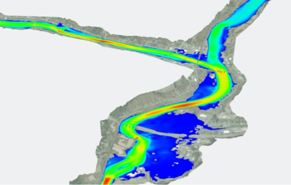 VTrans uses 2D modeling to improve bridge design in areas with complex hydraulics, such as this crossing over the White River, a tributary to the Connecticut River. The model shows flow velocities through the river’s reach. Credit: Vermont Agency of Transportation Background image: ESRI World Imagery
 Vermont – Before CHANGE
Prior to implementing CHANGE, VTrans staff relied on 1D hydraulic modeling software to analyze and size existing and planned bridge structures. Faced with the challenge of rehabilitating or replacing many of its aging bridges in low-lying valleys, VTrans was struggling with how to adequately inform, with confidence, a 1D model for bridges spanning meandering channels. Because the results of 1D modeling depend greatly on simplified assumptions, it can lead to overestimating or underestimating important results such as water surface elevations, velocities, scour depths, and consequently designed scour countermeasures.
“We understood that 1D models were not providing the results necessary to make sound engineering decisions for the interaction between complex flow patterns and highway infrastructure,” said State Hydraulics Engineer Nick Wark. “The 1D approach also made it very difficult for us to convey model results to stakeholders, including our bridge design teams.”
In fall 2015, VTrans hydraulics staff had participated in the National Highway Institute (NHI) Two-Dimensional Hydraulic Modeling of Rivers at Highway Encroachments training. Afterward, VTrans attempted to create a fully developed 2D hydraulic model, but the model was never completed due to a lack of intimate software knowledge and troubleshooting experience.
“We recognized that the NHI training outfitted us with the necessary means to get started,” said Keith Friedland, a member of the VTrans hydraulics team, “but as with any new tool or piece of equipment, there is always a learning curve after an initial introduction.”
CHANGE: Getting It Right
In late 2017, VTrans focused on implementing CHANGE and built its first fully successful 2D model. The model used two tools promoted model. The model used two tools promoted by EDC: Sedimentation and River Hydraulics – Two-Dimension (SRH-2D), a program developed at the U.S. Bureau of Reclamation, and Surface-water Modeling System (SMS) software.
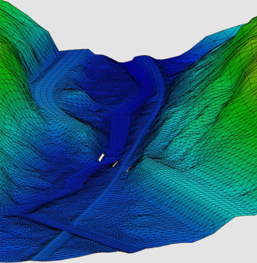 In this VTrans 2D model, the mesh represents terrain at a road crossing of a river and a railroad. The holes in the mesh represent piers. Velocity and depth can be computed at each element within the mesh. Credit: Vermont Agency of Transportation
 After developing the 2D model, staff found themselves with the technical ability to create and run models but with uncertain confidence in the results. “The difficult part was knowing whether the models we were creating were reliable and how to adequately review and verify our models when we were still in a learning phase,” said Wark.
Resources available through CHANGE helped guide VTrans through these unanswered questions. The initiative provided access to technical support from the FHWA Resource Center and consultants to review VTrans’ work and assist them with technical questions, enabling staff to fine-tune the model parameters and input needed to run efficient hydraulic models. They also received tips for extracting meaningful results. Additional resources VTrans found helpful were FHWA’s 2D Hydraulic Modeling User’s Forum webinars and online SMS tutorial videos.
“From the support we received through the EDC CHANGE initiative, we gained the skills necessary to develop and review our hydraulic models,” said Wark, “but for us to gain confidence, our team needed to continue building models and refine our skills along the way.”
Between 2017 and 2019, VTrans built seven 2D models with SRH-2D and SMS. With each new model came increased confidence and model development efficiency. Jeff DeGraff, another member of the VTrans hydraulics team, said “We found that once you have developed 5 to 10 successful 2D models, the modeling process time, from start to finish, is just as fast or even faster than the development of a 1D model.”
Today, nearly all programmed bridge design projects in Vermont are developed using 2D hydraulic models. Staff have now created more than 50 models with SRH-2D and SMS. For VTrans, the 2D approach is helping balance many competing demands. It enables the agency to more cost-effectively design its bridges while accommodating Vermont’s natural landscape, and its unprecedented graphical output supports design and construction of safer and more resilient structures over the State’s waterways.