

Interstate Highway System - Art Gallery
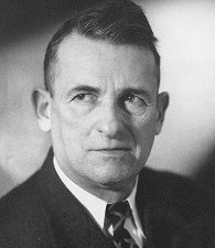
Carl Rakeman
Historic American Roads
Over the years, numerous writers, songwriters, and moviemakers have directed their creativity toward capturing the significance and eventfulness of highway travel. But for some reason, few studio artists have attempted to capture the romance of the road. Carl Rakeman was an exception.
For many years, the Federal Highway Administration’s (FHWA) predecessor agencies included a Visual Education office that was responsible for publications, exhibits, and motion pictures to be used in promoting the cause of good roads. From 1925 to 1950, the office was headed by Albert C. Rose, who doubled as the agency’s unofficial historian. Writing as “The Old Road Builder,” Rose collaborated with agency artist Carl Rakeman (pronounced Rock-a-mon) on a “Highways of History” project that eventually included 109 paintings with accompanying text describing and depicting a chronology of key events from 1539 (“The Coming of the Horse”) through 1945 (“Rural Interstate Highway” and “Urban Depressed Express Highway”).
This art gallery features a sampling of the Rakeman paintings, with Rose’s full text, beginning with Secretary of the Treasury Albert Gallatin’s 1808 Road and Canal Report—as Rose explained, the report “became the mold from which was cast our subsequent national transportation policies.” Other paintings cover construction of important 19th century roads; creation of the U.S. Office of Road Inquiry in 1893 (the FHWA’s first incarnation); early attempts to cross the continent by automobile and truck; and, some of the trends—through 1945 when the series ended—leading to the Dwight D. Eisenhower National System of Interstate and Defense Highways.
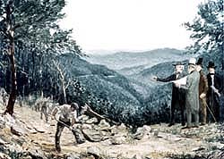
| 1808—Gallatin’s Road and Canal Report | |
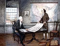 |
Albert Gallatin, Secretary of the Treasury Department, on April 4,1808, presented a report “respecting roads and canals,” at the request of the United States Senate, which became the mold from which was cast our subsequent national transportation policies. Secretary Gallatin urged, “early and efficient aid of the Federal Government” in order to “shorten distances, facilitate commercial and personal intercourse, and unite, by a still more intimate community of interests, the most remote quarters of the United States. Read more. |
| 1809—The Natchez Trace | |
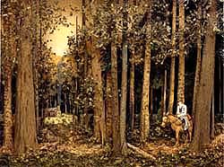 |
The Natchez Trace, extending from Nashville, Tennessee, to Natchez, the capital of Mississippi Territory, was the overland return route, through some 460 miles of forest wilderness and Indian lands, for the crews of the flatboats, which floated down the Mississippi but could not be poled upstream. The period of its greatest usefulness began in 1798 and ended in 1817 when steamboats dominated the great river. Although the Natchez Trace was opened officially by the United States Government in 1803, it followed a trail, which had been in existence from time immemorial. Read more. |
| 1826—The Michigan Road | |
 |
The Michigan Road was the main north-and-south route over which settlers swarmed into the State of Indiana. It was the overland bridge providing the shortest practicable route between the Ohio River and the Great Lakes during the pioneer period when the waterways were the principal arteries of travel. It connected Madison, on the northern bank of the Ohio River, with Michigan City on Lake Michigan. Contrary to the popular impression, the Michigan Road was not the main route over which pioneer settlers reached Michigan. The Michigan Road derived its name from the lake not the State. Read more. |
| 1827—The Northwestern Turnpike | |
 |
Incorporated in 1827, by an act of the General Assembly, the Northwestern Turnpike was the State of Virginia's bid for the lucrative trade of the Territory Northwest of the Ohio River. Maryland's access was by way of the National Pike, opened to Wheeling on the Ohio River in 1818. The great Pennsylvania Road had been turnpiked from Philadelphia to Pittsburgh by 1820. New York outdistanced all rivals in 1825, with the practically water-level grade across the mountains through the Erie Canal. Read more. |
| 1840—The National Pike | |
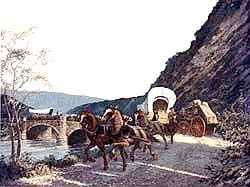 |
The National Pike, or Cumberland Road as it is named by statute, was the first important road to be built with Federal funds in this country. Now known as United States Route 40, the commissioners appointed by President Thomas Jefferson selected the location following the old portage path across the Allegheny Mountains from tidewater on the Potomac River at Cumberland, Maryland, to the nearest practicable head of navigation on the Monongahela branch of the Ohio River at Red Stone Old Fort (Brownsville, Pennsylvania), 72 miles away. Read more. |
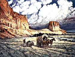
| 1843—Oregon Trail | |
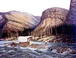 |
The Oregon Trail was the first overland wagon road to the Pacific Coast along which settlers trudged, rode, and sang in the greatest tide of travel that ebbed and flowed in pioneer America. Beginning at independence, Missouri, the Oregon Trail climbed steadily for 921 miles to the South Pass over the Continental Divide, and reached its highest elevation (8,200 feet) a short distance beyond Fort Bridger Thence the road ran downhill to Oregon City, 2,000 miles from Independence, except for the 5,000-feet-high Blue Mountains beyond Fort Boise and the 4,000-feet-summit of the Barlow Road south of Mount Hood. Read more. |
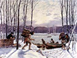
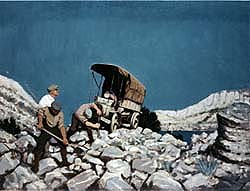
| 1858—Butterfield’s Overland Mail | |
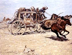 |
The first through overland mail service between the Mississippi River and the Pacific Coast was provided by the “Butterfield Overland Mail” stagecoaches in 1858, as shown in the accompanying illustration. As early as 1849, concurrent with the gold rush to California, regular United States mail was transported by steamboats from New York City, carrying also express and passengers to Chagres. Thence the trip was continued across the Isthmus of Panama by canoe and mule-back until the railroad was completed in 1855, to Panama City where another line of steamboats completed the journey to San Francisco. Read more. |
| 1892—Bicycling Days | |
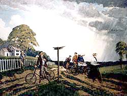 |
The pneumatic-tired “safety” bicycle had captured the imagination of the American people to such an extent by 1892 that newspapers and periodicals of that day referred to the bicycle “craze.” The mania found expression in riding schools organized to instruct novices in all the large cities; in the “Daisy Bell” popular song featuring “A Bicycle Built for Two”—the tandem; by slang words as “scorching” an exaggeration of the heat produced by the friction of the speeding vehicle with the road surface; and by the novel “rational dress” called “bloomers” which the ladies adopted so as to acquire greater freedom of movement. Read more. |
| 1893—First American Automobile | |
 |
What is generally accepted as the first
American gasoline-engine automobile in the United States was given a short road test on the streets of Springfield, Massachusetts, by its builder, J. Frank Duryea in September, 1893, as shown in the accompanying illustration. Actually gasoline-engine automobiles were operated on the streets as early as 1889 by Henry Nadig, at Allentown, Pennsylvania, in 1890 by Gottfried Schloemer at Milwaukee, Wisconsin, and in 1891 by Charles H. Black at Indianapolis, Indiana. Read more. |
| 1893—The Office of Road Inquiry | |
 |
One of the offspring of the “Good Roads Movement” was the Office of Road Inquiry, United States Department of Agriculture, authorized by a statute enacted by the Fifty-second Congress, approved by President Benjamin Harrison on March 3, 1893. The statute read in part, “To enable the Secretary of Agriculture to make inquiries in regard to the systems of road management throughout the United States, to make investigations in regard to the best methods of road-making, and to enable him to assist the agricultural college and experiment stations in disseminating information on this subject, ten thousand dollars.” Read more. |
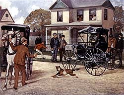
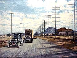
| 1903—First Transcontinental Automobile Trip | |
 |
Two events, in the year 1903, were straws in the wind pointing to the trend of the automobile industry. One was the spectacular transcontinental trip made by Dr. H. Nelson Jackson, a prominent surgeon, from Burlington, Vermont, in a 20-horse-power Winton touring car, which he purchased from a private owner in San Francisco by paying a premium above the $2,500 list price. Without fanfare, at his own expense, and motivated only by the ambition to be the first to complete the cross-country journey in a motor car, Dr. Jackson left the Golden Gate City on May 23, 1903, accompanied by his chauffeur Sewell K. Croker. Read more. |
| 1911—Motor Pathfinders | |
 |
The first transcontinental motor-truck trip made, in 1911, demonstrated the usefulness of the motor vehicle as a freight carrier. The motor truck now was ready to put on long pants and do a man's job. The journey was performed in a four-cylinder, 37 horse-power, gasoline-engine powered truck, called the” Pioneer Freighter" built by the Sauer Motor Car Company of New York. The vehicle was equipped with a chain drive from the counter shaft to the rear axle. Read more. |
| 1913—The Lincoln Highway | |
 |
The Lincoln Highway was conceived with the aim of building a great transcontinental object-lesson road at a time when there were no improved long-distance highways in the United States. In 1913 no State, nor probably any county, could boast of a completed highway system. As the motor vehicles rolled from the assembly lines and out into towns and through the countryside in growing numbers, Carl G. Fisher, who had been associated with the automobile industry from its infancy, envisioned the possibilities of a Coast-to-Coast Rock Highway. Read more. |
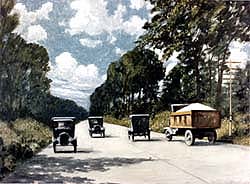
| 1918—First Federal-Aid Road | |
 |
The first unit completed under the authorization of the Federal Aid Road Act, approved by President Woodrow Wilson on July 11, 1916, was California Federal-Aid Road Project No. 3, situated in Contra Costa County and known locally as the “Alameda County Boundary to Richmond Road.” The project, shown in the accompanying illustration, was 2.55 miles in length and extended from Albany (Alameda County Boundary) to Richmond in Contra Costa County. Read more. |
| 1935—Viaducts in Cities | |
 |
The Emergency Relief Appropriation Act, approved by President Franklin D. Roosevelt on April 8, 1935, organized the first major attack upon the baffling problem of railroad grade crossings in cities. A great many rural, as well as a few metropolitan crossings had been eliminated in previous years with the aid of funds administered by the Bureau of Public Roads, United States Department of Agriculture. Read more. |
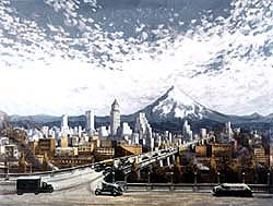
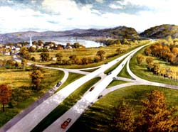
| 1938—City Entrances and Belt Lines | |
 |
With the initial surfacing virtually completed on the Federal-aid highway system, consisting of the principal State and interstate highways, there arose a widespread and justifiable demand for the extension of these main roads into and through centers of population by means of trans-city arteries and belt-line distribution thorough fares, or ring roads, as shown in the accompanying illustration. Read more. |
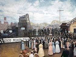
| 1939—A Highway Masterpiece | |
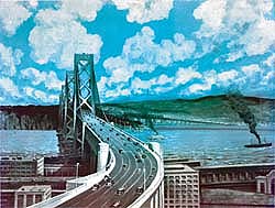 |
“An acetylene torch in the hands of Governor Frank F. Merriam burned asunder a heavy chain barrier, an electric button pressed by President Roosevelt in the White House in Washington flashed the green 'Go' signal and three columns of whirring automobiles sped from each shore of San Francisco Bay over six lanes of the world's greatest aerial highway—the San Francisco-Oakland Bay Bridge—a half hour after noon on November 12, 1936.” Thus began an article describing the opening in the California Highways and Public Works Magazine. Read more. |
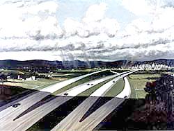
| 1945—A Rural Interstate Highway | |
 |
The National Interregional Highway Committee was appointed by President Franklin D. Roosevelt on April 14, 1941, “to investigate the need for a limited system of national highways to improve the facilities now available for interregional transportation, and to advise the Federal Works Administrator as to the desirable character of such improvement, and the possibility of utilizing some of the manpower and industrial capacity expected to be available at the end of the war.” Read more. |
| 1945—Urban Depressed Express Highways | |
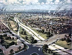 |
The report pertaining to Interregional Highways, transmitted to the Congress on January 12, 1944, contained this significant statement, “The city streets over which the urban mileage included in the recommended interregional system has been measured, are those now marked as the transcity connections of the existing main rural highways that conform closely to the rural sections of the recommended routes. These streets generally pass through or very close to the existing central business areas of the cities.” Read more. |
The Rakeman paintings were displayed at expositions and conventions around the country, as well as a Bicentennial exhibit of the complete collection at the Old Pension Building in Washington, D.C. from April through September 1976. That same year, the paintings and Rose’s accompanying text, were published as:
Rose, Albert C., Historic American Roads: From Frontier Trails to Superhighways,
Crown Publishers, Inc., 1976.
Prints of the Rakeman paintings have been used as illustrations in countless books, magazines, and newspapers.
Since November 2001, the FHWA Rakeman Transportation Painting Collection has been displayed at the Texas Transportation Institute at Texas A&M University in College Station, Texas.
For more information about Mr. Rakeman’s legacy, please visit http://www.tfhrc.gov/pubrds/janfeb02/exhibition.htm. On this page, you will find “A Legacy in Art in a New Exhibition” by George Austin Hay, a multimedia specialist on FHWA’s Public and Visual Communications Team. The article, which appeared in the January/February 2002 issue of FHWA’s Public Roads, included 18 of the Rakeman paintings along with a brief description of each one.