FINAL REPORT
A Report to
Battelle
Transportation Division
505 King Avenue
Columbus, OH 43201
and
Federal Highway Administration
U.S. Department of Transportation
400 Seventh Streets, S.W.
Washington, D.C. 20590
by
Mei-Po Kwan
Department of Geography
The Ohio State University
Columbus, OH 43210
October 16, 2000
This study was supported by the Federal Highway Administration (FHWA). Elaine Murakami of FHWA and David Wagner of Battelle Memorial Institute provided valuable and helpful suggestions at various stages of the project. Alan Pate and David Neumeister of Battelle Memorial Institute kindly performed matching operations that identify drivers’ gender using the original Lexington dataset. Without their help, the analysis on gender differences described in this report could not have been possible.
2. Conventional Accessibility Measures *
3. Limitations of Conventional Accessibility Measures *
4. Space-Time Accessibility Measures *
5. Study Area, Data and Methods *
6.1 Geovisualization of Travel Patterns Using GPS Data *
6.2 Geocomputation of Individual Space-time Accessibility Using GPS Data *
7. Conclusion and Future Prospects *
In recent debate on gender/ethnic differences in access to employment opportunities, concern about the difficulties in using the length of the commute trip as a measure of job access has been raised (McLafferty and Preston 1996; Wyly 1996). As either long or short work trips can be taken as indicator of spatial inequality in the access to employment (the former for inner-city minorities, the latter for suburban women employed in female-dominant occupations), it is recognized that "correct" interpretation of results depends on a contextualized understanding of the life situations of the individuals being studied. Other studies also suggest that the accessibility experience of individuals in their everyday lives is much more complex than what can be represented by conventional measures of accessibility (Hanson et al. 1997; Kwan, 1998; Pickup 1985).
In this technical report, the problem of using conventional measures to evaluate personal accessibility is examined. It is argued that these measures ignore the situational complexities of activity-travel behavior and the role of space-time constraints in shaping the accessibility experience of individuals. As these factors bear significantly upon women’s everyday lives, all conventional accessibility measures suffer from an inherent "gender bias" which is hitherto unnoticed. In view of these limitations of conventional accessibility measures, this study argues that defining accessibility as space-time feasibility instead of locational proximity would enable us to understand better the accessibility experience of individuals in their everyday lives. It proposes and provides formulations of alternative accessibility measures based on the construct of the space-time prism for studying gender differences in access to urban opportunities.
Despite the advantages of space-time accessibility measures, few studies have implemented them in the past due to their operational difficulties (e.g., the geoprocessing capabilities required). To examine gender differences in individual accessibility, a network-based GIS method was used to operationalize space-time measures based on the formulations of Burns (1979) and Kwan (1998). These methods were implemented using GPS-based trip data collected in the Lexington Area Travel Data Collection study (GPS) (Battelle 1997), a digital transportation network, and a geographic database of all facilities in the study area.
2. Conventional Accessibility Measures
Conventional accessibility measures are based on three fundamental elements (Hanson and Schwab 1987). First, a reference location serves as the point from which access to one or more other locations is evaluated. The reference location most often used is the home location of an individual, or the zone where an individual’s home is located when zone-based data are used. Second, a set of destinations in the urban environment is specified as the relevant opportunities for the measure to be enumerated. This set may include employment opportunities (for evaluating job access) or particular types of shops, services or facilities. Further, each opportunity may be weighted to reflect its importance or attractiveness. Third, the effect of the physical separation between the reference location and the set of urban opportunities on access is modeled by an impedance function, which represents the effect of distance decay on the attractiveness of an opportunity.
Based on these three elements, various types of accessibility measures can be specified. Morris et al. (1979) provide a helpful typology of accessibility measures by dividing them into two broad groups: relative and integral measures. Relative accessibility measures describe the degree of connection between two locations (Ingram 1971). It can be expressed in terms of the presence or absence of a transport link, physical distance or travel time between two locations. The length of the commute trip used in recent studies on the spatial mismatch between population subgroups and jobs belongs to this type of measures (e.g., Ihlanfeldt 1993). Integral measures, on the other hand, represent the degree of interconnection between a particular reference location and all or a set of other locations in the study area. They have the general form:
Ai = å Wjf(dij)
where Ai is the accessibility at location i, Wj is the weight for representing the attractiveness of location j, dij is a measure of physical separation between i and j (in terms of travel time or distance), and f(dij) is the impedance function. When the impedance function takes the form of a distance decay function similar to those found in gravity models, the access measure is a gravity-based measure (Handy and Niemeier 1997). The most commonly used distance decay functions include the inverse power and negative exponential functions. In the case where an indicator function is used as the impedance function to exclude opportunities beyond a given distance limit, the measure is a cumulative-opportunity measure (Wachs and Kumagai 1973). It indicates how many opportunities are accessible within a given travel time or distance from the reference location.
A further distinction could be made depending on whether an access index is enumerated and used as an indicator of physical or place accessibility (how easily a place can reach or be accessed by other places), or personal or individual accessibility (how easily a person can reach activity locations ). As will be shown below, this distinction is of considerable importance if the objective is to understand the accessibility experienced by individuals in their everyday lives, and to avoid the fallacy of ascribing the accessibility of a location or area (e.g., census tract) to a person at that location or in that area (Pirie 1979).
3. Limitations of Conventional Accessibility Measures
One major difficulty in using conventional measures to evaluate individual accessibility stems from the concept of accessibility they operationalize, namely, accessibility as locational proximity of opportunities with respect to a single reference location. There are several problems with this notion of accessibility. As accessibility is measured with respect to a single reference location such as home or the workplace, all travel or activities (whether actual or potential) which contribute to personal accessibility are assumed to be based on that single origin. This amounts to assuming that all potential trips, which contribute to the accessibility for a person residing at a particular location, start from that single reference point. Such assumption, however, deviates quite significantly from many characteristics of activity-travel behavior observed in past research.
As past studies have shown, a substantial proportion of intra-urban travel consists of multi-purpose, multi-stop journeys, and potential stops at various locations may become more accessible by virtue of their proximity to sites other than home or the workplace (Golledge and Stimson 1997; Hanson 1980; Kitamura et al. 1990; O’Kelly and Miller 1983). A study by Richardson and Young (1982) demonstrates that, without considering the effect of linked trip or trip chaining behavior, conventional measures may considerably underestimate the accessibility to activities of non-central urban locations. Similarly, Arentze et al. (1994) conclude that methods taking multi-purpose travel into account may lead to different evaluations of the differential accessibility in real world situations. The complex linkages and inter-dependencies between activities in a person’s daily life therefore render the evaluation of accessibility in terms of a single reference location problematic.
An example of this is the multi-purpose journey to work where the work trip is linked to travel to essential facilities. As observed in several studies, the availability of child care facilities is often an important factor determining the accessibility of certain job locations for women with young children (England 1996a,b; Hanson and Pratt 1990; Michelson 1985, 1988; Myers-Jones and Brooker-Gross 1996; Tivers 1985, 1988). In other words, access to jobs not only depends on where the jobs are, but also on the location of child care facilities which renders some job locations more feasible than others. Using the length of the commute trip as a relative measure of job access can therefore obscure the accessibility experience of individuals, especially women, in their everyday lives since job location may be constrained by the location of essential facilities rather than the reverse.
Another problem of conventional accessibility measures is their ignorance of the role of individual time-budget and space-time constraints in determining personal accessibility. As every individual faces a particular structure of space-time constraints imposed by the space-time fixity of obligatory activities in their everyday lives, personal accessibility is contextually constituted in the sequential unfolding of these activities (Pirie 1979). In other words, individual accessibility is determined not by how many opportunities are located close to the reference location, but by how many opportunities are within reach given the particularities of an individual’s life situation and adaptive capacity (Dyck 1989, 1990; England 1993). Conventional access measures based on locational proximity of opportunities to a single reference point simply cannot reflect inter-personal differences associated with these contingencies of everyday life. They tend to reflect place accessibility rather than individual accessibility.
Such inability of conventional accessibility measures to reflect individual differences besides those captured by the impedance function leads to an inherent bias when these measures are used to examine gender differences in accessibility. As many studies observed, women’s access to jobs and urban opportunities is determined more by their space-time constraints in everyday life than by other factors like travel mobility or relative location to opportunities (Hanson and Pratt 1990, 1995; Miller 1982, 1983). Further, those constraints associated with women’s socially ascribed gender-role tend to be spatially and temporally more binding for women than for men (Johnston-Anumonwo 1992; Pickup 1984, 1985; Pratt and Hanson 1991; Tivers 1985). These factors led Pickup (1985, 106) to conclude that, "Conventional ‘spatial’ accessibility measures of access to shops or jobs were meaningless for women whose activity choices were continually facing additional time constraints from their gender role. For the analysis of men’s job choices, such measures might have more adequacy." Results from Kwan’s (1998) study, which observes that the spatial pattern of individual accessibility for men has a stronger relationship with place accessibility than that for women, forcefully support this argument. To overcome the inherent gender insensitivity of conventional accessibility indices, space-time measures based on the time-geographic framework provide attractive alternatives.
4. Space-Time Accessibility Measures
All space-time measures of individual accessibility are based on Hägerstrand’s (1970) time-geographic framework and the space-time prism construct. Lenntorp (1976) provides the earliest operational formulations of space-time accessibility measures based on the notion of an individual’s reach, which is the physically accessible part of the environment given the individual’s space-time constraints. In three-dimensional terms, this accessible portion is the space-time prism or potential path space (PPS). The projection of the prism onto planar geographic space delimits the reachable area by the individual and is called the potential path area (PPA). The notion of space-time prism, however, can be explained using two-dimensional graphs, such as the one shown in Figure 1. This figure visually defines the outer bounds of opportunities that can be reached by a person giving two particular space-time constraints. It shows the accessible geographical area (on the "space" axis) for a mother who has to be at work until 5:00 p.m. and who must arrive at the child-care center no later than 6:00 p.m. to pick up her daughter. Somewhere in between, she needs to stop at a food store to buy some grocery. The slope of the lines shows the maximum speed that this person can travel. The prism outlines the envelope within which lies the set of all places that are accessibility to her given these constraints. If no food store exists between A and B (shown on the "space" axis), then she lacks accessibility in this instance.
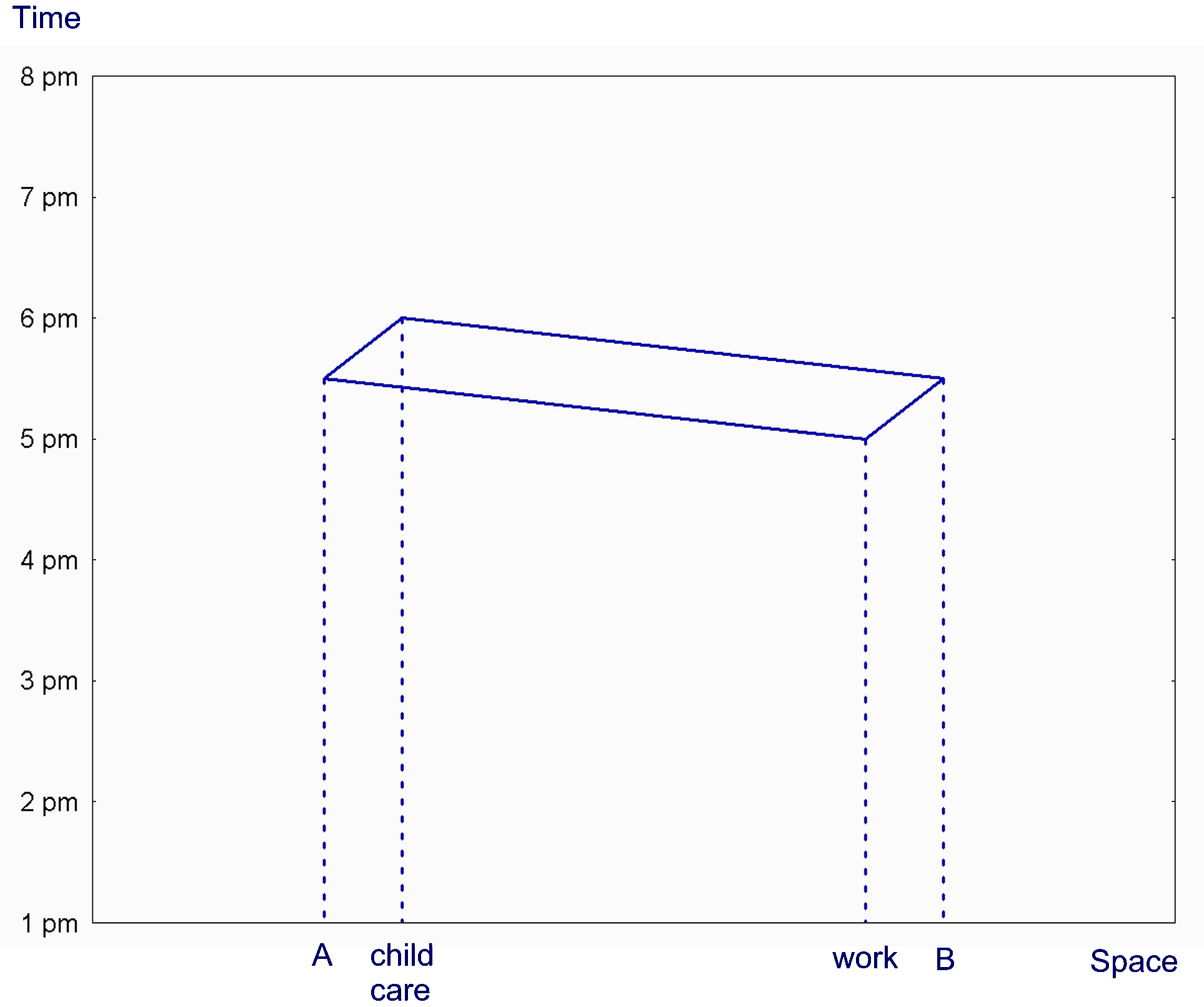
Figure 1. Space-time prism and potential path area (PPA).
PPA in this case is delimited by points A and B.
(Adapted from Hanson [1995])
The volume of the space-time prism and the area delimited by the PPA were specified as accessibility measures by Lenntorp. Another early formulation was provided by Burns (1979), who conceptualizes individual accessibility as the freedom to participate in different activities. Based on the concept of space-time autonomy, he formulates two accessibility measures using the space-time prism construct. One is based on the set of locations reachable by an individual, while the other is based on the set of reachable routes of the transportation network.
There are several extensions of the original formulations of space-time accessibility measures after Lenntorp and Burns. Landau et al.’s (1982) study identifies the feasible locations to be included in an individual’s destination choice set based on the person’s space-time constraints and the minimum amount of time required for an activity. Kwan and Hong (1998) incorporate the effect of spatial knowledge on the size and spatial configuration of the choice set based on an extension of Golledge et al.’s (1994) work on the feasible opportunity set. By extending the problem of destination choice from a particular activity to all non-fixed activities on a day, the size of the choice set or feasible opportunity set delimited in these studies can be formulated as space-time measures of individual accessibility. Villoria (1989) proposes the concept of time-space reach (TSR) as a measure of individual accessibility and implements it using geometric methods. Miller (1991) and Kwan (1998) develop different network-based GIS methods for operationalizing space-time accessibility measures.
5. Study Area, Data and Methods
The study area for this research is the two-county (Fayette and Jessamine) region in central Kentucky under the jurisdiction of the Lexington Area Metropolitan Planning Organization (MPO). This region is about 461 square miles in area and has a total population of about 350,000. The GPS data used in this study were collected in the Lexington Area Travel Data Collection Test study (Battelle 1997).
This Lexington GPS pilot study was an innovative project initiated by the FHWA Office of Highway Information Management. The study involved both automated data collection using Personal Digital Assistants (PDA) and GPS, as well as respondents’ self-reporting of activities and trips (see Battelle [1997] for details of the survey). The primary objective of the Lexington project was to see if people would be willing to use such a data collection device and whether or not they could operate the equipment, and if the equipment was reliable enough to use. Due to limitations arising from power constraints and weight of the PDAs used, the pilot study was able to collect only data of vehicle trips (where electric power from vehicles was used to operate the PDAs). Despite this limitation of the dataset, it is still of considerable value since GPS trip data have not been available to transportation planners and researchers before. Murakami and Wagner (1999) had used the dataset to examine whether using automated data collection would improve trip reporting, while Yalamanchili et al. (1999) used it to study individual activity chaining behavior. The purpose of this study is largely exploratory. It aims at developing GIS-based methods for analyzing this kind of data and deriving implications for improving future efforts of data collection and analysis involving GPS data.
As a Personal Digital Assistant (PDA) and the Global Positioning System were used in the data collection test, and post-processing of the GPS data generated another type of data, four types of data are available from the original dataset (see Battelle 1997). These include PDA data, GPS data, match data and recall data. Since the match data were generated through post-processing the GPS data to eliminate obvious errors and to improve positional accuracy of the original GPS data, they were used in the analysis described in this report. These data files, mainly MatchLin and MatchPnt, are stored in the "GISTrips" directory on the Lexington study data CD.
The original data set contains information of 216 licensed drivers (100 male, 116 female) from 100 households with an average age of 42.5 (ranging from 16 to 77). These households had 2.9 persons and 2.2 vehicles on average. Education levels for the 216 drivers sampled were relatively high - 20 percent of the individuals have college degrees and another 20 percent have some post-secondary education. The average distance driven per year for each driver was 13,118 miles (Battelle 1997). In total, data of 2,758 GPS-recorded trips were collected which consist of 794,861 data points of latitude-longitude pairs and time.
Although the purpose of this exploratory project is to examine gender differences in individual accessibility using the GPS data, a difficulty in identifying the gender of a particular driver in the original sample was encountered during data analysis. It was mainly due to the different personal identification key used in the GPS data and interview data. While personal and household attributes were provided in the interview data (in the subdirectory Database), no such data was provided in the GPS data files (in the files "gpsout.dbf" in the MatchLin subdirectory and "gpsoutp.dbf" in the MatchPnt subdirectory). Further, since the unique correspondence of these two sets of identification key was not available in the original dataset, there is no way to determine the personal attributes (hence gender) of a driver in the GIS data files. To overcome this difficulty, driver names in the original GPS and interview data were used to provide a unique and matched identification of all the drivers in the sample (this was performed by Alan Pate and David Neumeister of Battelle). Gender of 125 drivers in the GPS data were identified using this method. For the most part, matches were made based on the driver's name. In a couple of cases, the name was left blank by the driver when GPS data were collected. By examining the GPS trips made on the recall day with the trips reported on the post interview, it was possible to also match these drivers. Note that in some cases, this process resulted in two GPS drivers being matched with the same interview driver because it was possible to match one of the left-blank drivers to a driver that correctly selected his/her name for other trips. Due to these difficulties, all cases with any potential for mistaken gender in the matched data file were eliminated.
This finally led to a usable subsample of 89 drivers (46 male, 43 female) whose gender were identified without ambiguity. With an average age of 40.7 years, these individuals are slightly younger than the larger sample (with an average age of 42.5). Further, as each of these individuals traveled 16,630 miles a year on average, they traveled more than the original sample as a group (13,118 miles per year). The GPS dataset of these 89 individuals contains 610,378 data points of latitude-longitude pairs and time.
|
Without children under 16 |
With children under 16 |
Total |
|
|
Male |
28 |
18 |
46 |
|
Female |
22 |
21 |
43 |
|
Total |
50 |
39 |
89 |
Two digital data sets provide additional information needed for this study. One is a digital database of 14,170 commercial facilities and stores in the study area extracted from the digital phone directory PhoneDisc PowerFinder 1996. At this stage of the analysis, particular landuse types are not distinguished, although future analysis can differentiate between individual accessibility to different types of facilities using the SIC codes provided in the digital database. The spatial pattern of these urban opportunities is shown in Figure 2. The figure indicates that urban opportunities in Lexington metropolitan area are located mainly around Lexington city within the ring road Highway 4. Minor peaks are found in Jessamine County in the Nicholasville and Wilmore areas.
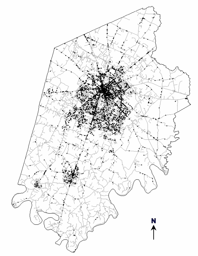
Figure 2. Location of urban opportunities in Lexington
metropolitan area.
Another source of data is a TIGER digital street network of the study area. This network database has adequate address ranges for geocoding locations. Facility locations extracted from the digital phone directory are geocoded on this street network using ArcView GIS.
Two methods were used to examine gender differences in individual accessibility in this study. The first method is the interactive 3D geovisualization of trip patterns recorded in the Lexington survey. The second method is the geocomputation of individual accessibility of the participants in the survey.
6.1 Geovisualization of Travel Patterns Using GPS Data
The conceptual basis for the GIS-based 3D geovisualization methods discussed below is the time-geographic perspective formulated by Hägerstrand (1970) and his associates. In time-geographic conception, an individual’s activities and trips in a day can be represented as a daily space-time path within a ‘prism’ defined by a set of constraints (Hägerstrand, 1970; Lenntorp, 1976). This time-geographic conception is valuable for understanding activity-travel behavior because it integrates the temporal and spatial dimensions of human activity patterns into a single analytical framework. Although time, in addition to space, is a significant element in structuring individual activity patterns, past approaches mainly focus on either their spatial or temporal dimension. The significance of the interaction between the spatial and temporal dimensions in structuring individual daily space-time trajectories are often ignored. Yet, using the concepts and methods of time-geography that focus on the 3D structure of space-time patterns of activities, not only this kind of interaction can be examined, but also many important behavioral characteristics of different population subgroups can be revealed. As a result, many transportation researchers have found the time-geographic perspective useful for understanding human activity-travel behavior (Janelle and Goodchild 1983; Kitamura et al. 1990; Kondo and Kitamura 1987; Kwan 1998, 1999a,b; Recker et al. 1983).
This section focuses on the interactive 3D geovisualization of space-time paths. For the visualization of individual space-time paths, the earliest 3D method is the ‘space-time aquarium’ conceived by Hägerstrand (1970). In a schematic representation of the ‘aquarium’, the vertical axis is the time of day and the boundary of the horizontal plane represents the spatial scope of the study area. Individual space-time paths are portrayed as trajectories in this 3D aquarium. Although the schematic representation of the ‘space-time aquarium’ was developed long ago, it has never been implemented using real activity-travel diary data. The main difficulties include the need to convert the activity data into "3Dable" formats that can be used by existing visualization software, and the lack of comprehensive geographic data for representing complex geographic objects of the urban environment. The recent incorporation of 3D capabilities into GIS packages and the availability of contextual geographic data of many metropolitan regions have greatly reduced these two difficulties. Kwan (2000a) discussed the usefulness of 3D geovisualization for transportation planners and researchers when dealing with space-time activity-travel diary data.
First, few modeling techniques were designed to handle real geographical locations of human activities and trips in the context of a study area. Often, the spatial dimension is represented by some measures derived from real geographical locations (e.g. distance or direction from a reference point such as home or workplace of an individual). Further, locational information of activities and trips was often aggregated with respect to a zonal division of the study area (e.g. traffic analysis zones). Using such zone-based data, measurement of location and/or distance involves using zone centroids where information about activity locations in geographic space and their spatial relations with other urban opportunities is lost (Kwan and Hong 1998). The increasing availability of point-based activity-travel data geocoded to street addresses, including trip data collected by GPS, calls for new analytical methods that can handle the location of activities and trips in real geographic space. Three-dimensional geovisualization has significant potential for exploratory analysis of this kind of data.
Second, since many modeling methods (e.g. log-linear models) are designed to deal with categorical data, organizing the original data in terms of discrete units of space and time has been a necessary step in most analyses of activity-travel patterns in the past. Discretization of temporal variables, such as the start time or duration of activities, involves dividing the relevant span of time into several units and assigning each activity or trip into the appropriate class (e.g. dividing a day into 8 or 12 temporal divisions into which activities or trips are grouped). Discretization of spatial variables, such as distance from home, involves dividing the relevant distance range into several "rings". Since both the spatial and temporal dimensions are continuous, results of any analysis that are based upon these discretized variables may be affected by the particular schema of spatial and/or temporal divisions used. The problem may be serious when dealing with the interaction between spatial and temporal variables since two discretized variables are involved. Geovisualization may have an important role to play in alleviating this difficulty since the space-time patterns of the original data can be explored before they are discretized for further analysis or modeling.
Third, as the complexity and amount of activity-travel data increase considerably in recent years (e.g. the use of GPS data), effective methods for exploring these data are also urgently needed. Without them, the researcher may need to model activity-travel patterns without a preliminary understanding of the behavioral characteristics or uniqueness of the individuals in the sample at hand. This can be costly in later stages of a study if the model’s specifications fail to take into account of the behavioral anomalies involved. Since exploratory data analysis (EDA) can often lead to more focused and fruitful methods or models in later stages of a study, the recent development and use of scientific visualization for EDA suggest a possible direction for overcoming the problem (Gahegan, 2000). Recent developments in the integration of scientific visualization and exploratory spatial data analysis (ESDA) also indicate the potential of geovisualization for the analysis of activity-travel patterns (Anselin, 1998, 1999).
This study explores the application of interactive geovisualization (or geovisualization) in the analysis of georeferenced activity-travel data collected by GPS. To implement 3D geovisualization of the space-time aquarium, three contextual geographic data layers of the Lexington metropolitan area are first converted from 2D map layers to 3D shape files and added to a 3D scene. These include the boundary of the Lexington metropolitan region, highways and major arterials. As an illustration, the 3D space-time paths of the women without children under 16 years of age in the sample are generated and added to the 3D scene. These procedures finally created the scene shown in Figure 3. The overall pattern of the space-time paths for these women who have no children under 16 shown in this figure indicates that their trips were undertaken using largely highways and major arterials. There are some regularity as indicated by the daily repetition of trips in more or less the same time throughout the 6-day survey period. This suggests that activity-travel behavior can be captured in terms of particular space-time patterns.
With the 3D space-time paths and other contextual layers in view, the figure gives the researcher a strong sense about the geographical context. This interactive virtual environment not only contextualizes the visualization in its actual geographical surrounding but also enables the analysis of local variations at fine spatial scales. For instance, color codes can be used to differentiate between different landuse types. This would give the analyst a sense of the potential interaction space and its context, which can then be compare to activities and paths of the individuals (where activities and stops can also be color coded by activity type). This approach, as shown in Kwan (2000), will therefore have considerable potential for the development of person-specific, activity-based methods at fine spatial scales.
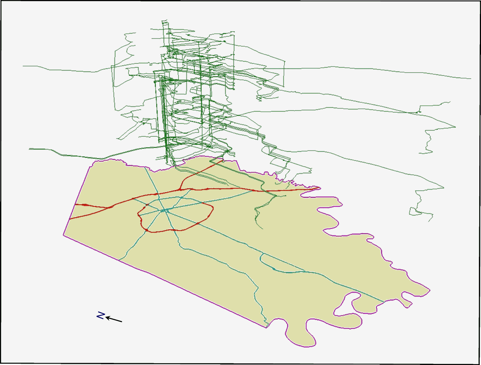
Figure 3. Space-time paths of women without children under 16
in the household
6.2 Geocomputation of Individual Space-time Accessibility Using GPS Data
The concept behind the operational method used to enumerate space-time accessibility in this study can be explained as follows. Every individual has a daily activity program consisting of a number of out-of-home activities. Among these activities, some are spatially and/or temporally fixed for the individual (e.g., workplace), while others can be undertaken at various locations or times of the day (e.g., grocery stores). The former type of activities are referred to as "fixed activities" which serve as "pegs" in the daily space-time trajectory of the individual (Cullen et al. 1972). Since the area in the urban environment within reach by an individual is determined by the space-time requirements associated with these fixed activities, the feasible region for an individual on a particular day can be derived based on the space-time coordinates of consecutive pairs of fixed activities. This is done through the following steps.
For any given pair of consecutive fixed activities, a given amount of time is available for travel and participation in "flexible" activities between them. Based on the locations of the pair of fixed activities in question, a spatial search is performed on the transportation network to find all urban opportunities within reach given this time constraint. The area so identified is the potential path area (PPA), which delimits the area containing all feasible routes and urban opportunities given the space-time constraints defined by the particular pair of fixed activities (Burns 1979; Miller 1991). If the individual has n out-of-home fixed activities to perform on a day, there will be n+1 pairs of consecutive fixed activities when the starting and ending home stops are regarded as fixed space-time pivots. This in turn means that n+1 distinct PPAs can be delimited. To obtain the set containing all feasible opportunities for the day, these individual PPAs are aggregated to form a daily potential path area (DPPA).
These procedures for deriving the DPPA are illustrated in Figure 4 using the actual travel diary data of a resident of Franklin County, Ohio (Kwan 1999a). This person performed three out-of-home activities on the day: work, attending an event at a church, and having a meal at a restaurant before returning home. With the former two activities being fixed, three PPAs are identified based on three consecutive pairs of fixed locations along the person’s space-time path (with the starting and ending home stops included as fixed locations). These three individual PPAs (in the middle of the diagram) are then aggregated to form the daily potential path area. Based on this delimitation of the DPPA, three space-time measures of individual accessibility can be specified: (a) the number of opportunities included in the DPPA, (b) an area-weighted sum of all opportunities contained in the DPPA, and (c) length of the network arcs or road segments included in the DPPA.
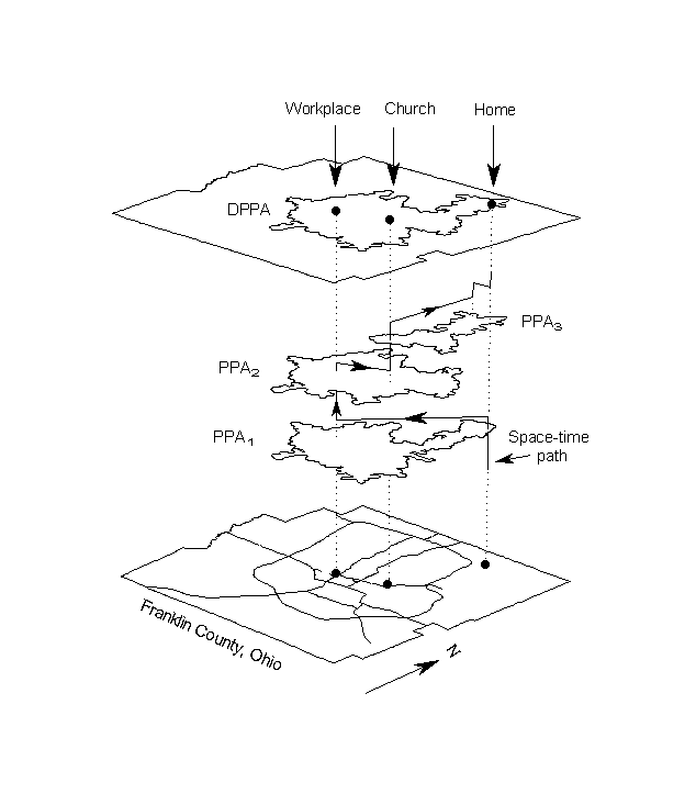
Figure 4. Derivation of the daily potential path area (DPPA).
(Source: Kwan [1999a])
To implement these space-time measures, not only detailed travel diary and time-budget data are needed. Geoprocessing capabilities are also required to handle a person’s daily activity schedule (including the locations of all fixed activities), the complexities of a realistic travel environment (e.g., transport network geometry and variations in travel speed), and the spatial distribution of urban opportunities. Without these, past attempts to operationalize the prism construct had to resort to geometric methods based on the straight-line distance between fixed activities (e.g., Lenntorp 1976). Although the PPAs or DPPA so derived take the familiar shape of spatial ellipses, they are far from being realistic representations of an individual’s PPAs or DPPA, which are not likely to be in any convenient geometric shapes (as showed in Figure 3). Further, it was not possible to evaluate the number and composition of opportunities included in an individual’s DPPA without incorporating information about urban opportunities into a geographic database. With the spatial data handling capabilities of recent GIS and the development of network-based GIS methods (Miller 1991; Kwan and Hong 1998), meeting some of these requirements for computing space-time accessibility has become possible.
The Lexington GPS data set, however, has several limitations that make the implementation of the GIS-based accessibility measures described above difficult. First, the GPS data collected were based on trips made by the primary vehicle in a household. The data do not provide complete coverage of a person’s daily activities and trips since different persons in the household may use the same primary vehicle to make trips at different times. Second, no data on individual time budget and fixity constraint were collected, although these are essential for computing space-time measures of individual accessibility (see Kwan [2000b] for a detailed operational definition of fixity constraint, which is the extent to which an activity is relatively fixed in location and time). The method described above cannot be implemented fully in light of these limitations. Third, since detailed parcel-level data, including landuse type and parcel size, were not available for this study, the geocomputational procedures treated each urban opportunity the same without considering the effect of landuse and parcel size. If these data had been available, different weights can be assigned to each land parcel according to these attributes to reflect more accurately their importance or attractiveness to individuals (as done in Kwan [1999a] and Weber and Kwan [2000]).
Results reported below were obtained using a GIS-based algorithm which search all urban opportunities within 0.25 mile of a person’s space-time path as recorded by the GPS. Note that the number of urban opportunities within reach defined in this way may not accurately reflect a person’s space-time accessibility as defined in Kwan (1998; 1999a). To make the analysis more meaningful, the individuals in the sample were divided into four categories according to their gender and the presence of children under 16 in the household. The average number of urban opportunities accessible to all individuals of the four groups throughout the 6-day survey period is 2,465. The average number of urban opportunities for each of these groups are given in the table below.
|
Average Number of Urban Opportunities |
Without children under 16 |
With children under 16 |
|
Men |
2,366 |
2,377 |
|
Women |
2,273 |
2,774 |
As indicated by the table, the number of opportunities accessible to men is very similar independent of the presence of children under 16 in the household. There is, however, a considerable difference between women with respect to the presence of children under 16 in the household. For women in households without children under 16, the number of accessible opportunities is similar to that of men. But women in households with children under 16 have 500 accessible opportunities more than that of women without children under 16 in the household. Although an ANOVA test fails to reject the null hypothesis that there is no difference between the two groups of women, a larger sample and more complete coverage of a person’s daily activities and travel may provide support for statistically significant difference between these two groups of women. Further, this result does not necessarily mean that women with children under 16 enjoy higher levels of individual accessibility since this analysis did not take into account the effect of time-budget and fixity constraint.
7. Conclusion and Future Prospects
As elaborated earlier in this report, the Lexington GPS pilot study was an innovative project aiming at determining: (a) whether survey respondents would be willing to use PDAs or hand-held computers as data collection devices; (b) whether survey respondents could operate the equipment without much difficulty and a steep learning curve; and (c) whether the equipment was reliable enough to use in real-world survey situations. Due to limitations arising from power constraints and weight of the PDAs used, the pilot study was able to collect only data of vehicle trips (where electric power from vehicles was used to operate the PDAs). Despite this limitation, the dataset is still of considerable value since GPS trip data have not been available to transportation planners and researchers before. After the studies of Murakami and Wagner (1999) and Yalamanchili et al. (1999), which uses the Lexington GPS dataset, this study explored and developed methods for analyzing this kind of data. Given the pilot nature of the original data collection effort, the results described in this report are largely preliminary. There are many possibilities for more detailed analysis of this dataset using GIS-based geocomputational methods. For instance, distinctive space-time trip patterns can probably be observed between the four groups of individuals, although only those of the women without children under 16 in the household are reported above. Further, many important implications for future efforts of collecting and analyzing GPS activity-travel data can be drawn from this study.
It is apparent that comprehensive data are required for the accurate analysis of individual activity-travel behavior. Future studies need to be extended not only to cover all vehicles in a household, but also to record the activities and trips a person undertakes throughout the survey period whether these activities involve travel or not, and independent of which vehicle the person used. In light of the unprecedented analytical opportunities provided by the fine-scaled space-time details of this kind of data, the collection of comprehensive multimodal activity-travel diary data using both GPS-based and interview-based methods is a very promising direction. Such a combination of conventional diary survey and GPS data collection methods will provide important benefits in terms of the usability and analytical opportunities of the data sets collected.
On the one hand, this kind of data would allow the accurate reconstruction of a person’s daily activity-travel pattern with considerable space-time details. The reconstructed patterns (as revealed preference of travelers) can be used for various purposes, including the study of route planning and route choice behavior and activity scheduling involving complex space-time trade-offs and real-time responses (as in the context of Intelligent Transportation Systems). Further, as the precise space-time trajectories of walking trips can be recorded, transport problems of the mobility-impaired populations (such as disabled, blind or elderly people) can be analyzed in great space-time details. On the other hand, this kind of data will enable the development of a whole range of new analytical and modeling methods useful to transportation planners and researchers. Given the recent development and application of GIS and spatial statistics in many areas of human spatial behavior, it is now possible to analyze and model individual travel behavior in relation to a realistically represented urban environment - in the form of a comprehensive geographic database of the study area that includes information about all land parcels and all street segments (including segment-specific travel speed and turn restrictions). The GIS-based 3D geovisualization methods described in this report is an example.
Several recent trends are particularly encouraging with respect to the future deployment of GPS-based activity-travel data collection. First, with Selective Availability (SA) now phased out, the cost of collecting GPS data with a high level of positional accuracy has dramatically decreased. When SA was in effect, the use of costly differential GPS (DGPS) was essential for eliminating the errors introduced by SA and for increasing the accuracy of the GPS data collected. After SA was phased out and taking into account the cumulative effect of the remaining error sources (without using DGPS), an autonomous GPS position can be expected to be in error by approximately 10 meters - which is significantly better than the ±100-meter accuracies under SA (Harrington 2000). As low-cost GPS receivers can now achieve much greater positional accuracy than when SA was in effect, using GPS in large scale activity-travel survey has become more feasible than before.
Second, the dramatic increase in the popularity of various kind of hand-held devices - such as 3Com’s palm PDAs and the palm PCs of other vendors - in the last few years has rendered the use of these palm devices in GPS-based data collection feasible. These devices have a number of advantages in this context. Their low power consumption and versatility allow for their use for non-vehicular travel modes (while handheld PCs in the past depended on the power supply of a vehicle). Further, as these devices are increasingly popular among broad segments of the population, using these devices for GPS-based data collection will become more feasible (as people already have experiences in using these devices in their daily lives). Lastly, as many location-aware accessories (largely GPS attachments) for these palm devices are now available, it is possible to develop a compact and portable data collection unit at a reasonable cost that meet both the accuracy and performance requirements for this kind of travel survey.
Future studies, however, still need to address a number of difficulties when collecting GPS data. The discontinuities in GPS data due to the problem of "loss of fix" (largely due to temporary loss of adequate satellite signals for determining positions) has to be minimized since they require considerable time and effort to deal with during data pre-processing. Other problems that may reduce the accuracy of GPS data, such as errors due to the problem of multipath, need to be addressed.
Another type of difficulties are associated with the computational intensity of processing large GPS datasets. The original dbf file of the Lexington study, for instance, contains 794,861 data points of latitude-longitude pairs and time. It takes up about 230 megabytes of disk space in the format provided in the Lexington data CD. The GPS dataset of the 89 individuals selected for this study, after extraction and transformation into a more compact format, consists of 610,378 data points of latitude-longitude pairs and time and takes up about 80 megabytes disk space. Manipulating files of these sizes is simply very demanding on the computing power of the hardware and the computational efficiency of the algorithm used. The PC that the author used to conduct this study - a 500 MHz Pentium III PC with 256 MB memory, two 10,000 rpm SCSI hard drives and 16 MB RAID controller buffer - responded very sluggishly to many geocomputational and geovisualization tasks. Although improvement in computing power in the near future will reduce this problem, much research is still needed to develop more efficient algorithms and data manipulation methods for handling large activity-travel GPS datasets. For example, instead of including all GPS data points, procedures for reducing and generalizing GPS data can be developed to reduce the problem of storage and computational intensity. New geocomputational methods also need to be developed when this kind of GPS data are used with large and complex geographic datasets.
Anselin, L., 1998. Exploratory spatial data analysis in a geocomputational environment. In: Longley, P.A., Brooks, S.M., McDonnell, R., MacMillan, B., (Eds.), Geocomputation: A Primer. John Wiley & Sons, New York, pp.77-94.
Anselin, L., 1999. Interative techniques and exploratory spatial data analysis. In: Longley, P.A., Goodchild, M.F., Maguire, D.J., Rhind, D.W., (Eds.), Geographic Information Systems, Vol. 1: Principles and Technical Issues, second edition. John Wiley & Sons, New York, pp.253-266.
Arentze, Theo A., Aloys W.J. Borgers, and Harry J.P. Timmermans. 1994. Geographical information systems and the measurement of accessibility in the context of multipurpose travel: a new approach. Geographical Systems 1:87-102.
Battelle. 1997. Lexington Area Travel Data Collection Test: Final Report. Battelle.
Burns, Lawrence D. 1979. Transportation, Temporal, and Spatial Components of Accessibility. Lexington, MA: Lexington Books.
Cullen, Ian, Vida Godson, and Sandra Major. 1972. The structure of activity patterns. In Patterns and Processes in Urban and Regional Systems, ed. A.G. Wilson, 281-96. London: Pion.
Dyck, Isabel. 1989. Integrating home and wage workplace: women’s daily lives in a Canadian suburb. Canadian Geographer 33(4):329-41.
Dyck, Isabel. 1990. Space, time, and renegotiating motherhood: an exploration of the domestic workplace. Environment and Planning D 8:459-483.
England, Kim. 1993. Suburban pink collar ghettos: the spatial entrapment of women? Annals of the Association of American Geographers 83:225-42.
England, Kim. 1996a. Who will mind the baby? In Who Will Mind the Baby? ed. Kim England, 3-19. London: Routledge.
England, Kim. 1996b. Mothers, wives, workers: the everyday lives of working mother. In Who Will Mind the Baby? ed. Kim England, 109-22. London: Routledge.
Gahegan, M., 2000. The case for inductive and visual techniques in the analysis of spatial data. Journal of Geographical Systems 2(1):77-83.
Golledge, Reginald G., and Robert J. Stimson. 1997. Spatial Behavior: A Geographic Perspective. New York: Guilford.
Golledge, Reginald G., Mei-Po Kwan, and Tommy Gärling. 1994. Computational process modeling of household travel decisions using a geographical information system. Papers in Regional Science, 73(2):99-117.
Hägerstrand, Törsten. 1970. What about people in regional science? Papers of the Regional Science Association 24:7-21.
Handy, Susan L., and Debbie A. Niemeier. 1997. Measuring accessibility: an exploration of issues and alternatives. Environment and Planning A 29(7):1175-94.
Hanson, Susan. 1980. The importance of the multi-purpose journey to work in urban travel behavior. Transportation 9:229-48.
Hanson, Susan. 1995. Getting there: Urban transportation in context. In Susan Hanson, ed. The Geography of Urban Transportation, second edition, 3-25. New York: Guildford.
Hanson, Susan, and Geraldine Pratt. 1990. Geographic perspectives on the occupational segregation of women. National Geographic Research 6(4):376-399.
Hanson, Susan, and Geraldine Pratt. 1995. Gender, Work, and Space. London: Routledge.
Hanson, Susan, and Margo Schwab. 1987. Accessibility and intraurban travel. Environment and Planning A 19:735-48.
Hanson, Susan, Tara Kominiak, and Scott Carlin. 1997. Assessing the impact of location on women’s labor market outcomes: A methodological exploration. Geographical Analysis 29(4):282-97.
Harrington, Andres. 2000. How will SA removal affect GPS/GIS integration. GEOWorld 13(8):28.
Ihlanfeldt, Keith R. 1993. Intra-urban job accessibility and Hispanic youth employment rates. Journal of Urban Economics 33:254-271.
Ingram, D.R. 1971. The concept of accessibility: a search for an operational form. Regional Studies 5:101-107.
Janelle, Donald G., and Michael F. Goodchild. 1983. Space-time diaries and travel characteristics for different levels of respondent aggregation. Environment and Planning A 20(7):891-906.
Johnston-Anumonwo, Ibipo. 1992. The influence of household type on gender differences in work trip distance. Professional Geographer 44:161-69.
Johnston-Anumonwo, Ibipo. 1997. Race, gender, and constrained work trips in Buffalo, NY, 1990. Professional Geographer 49(3):306-17.
Kitamura, Ryuichi, Kazuo Nishii, and Konstadinos Goulias. 1990. Trip chaining behavior by central city commuters: a causal analysis of time-space constraints. In Developments in Dynamic and Activity-Based Approaches to Travel Analysis, ed. P. Jones, 145-70. Aldershot: Avebury.
Kondo, K., and R. Kitamura 1987. Time-space constraints and the formation of trip chains. Regional Science and Urban Economics 17(1):49-65.
Kwan, Mei-Po. 1998. Space-time and integral measures of individual accessibility: a comparative analysis using a point-based framework. Geographical Analysis 30(3): 191-217.
Kwan, Mei-Po. 1999a. Gender and individual access to urban opportunities: A study using space-time measures. Professional Geographer, 51(2):210-227.
Kwan, Mei-Po. 1999b. Gender, the home-work link, and space-time patterns of non-employment activities. Economic Geography, 75(4): 370-394.
Kwan, Mei-Po. 2000a. Interactive geovisualization of activity-travel patterns using three-dimensional geographical information systems: A methodological exploration with a large data set. Transportation Research C 8:185-203.
Kwan, Mei-Po. 2000b. Gender differences in space-time contrsint. Area 32(2):145-156.
Kwan, Mei-Po, and Xiao-Dong Hong. 1998. Network-based constraints-oriented choice set formation using GIS. Geographical Systems 5:139-162.
Landau, Uzi, Joseph N. Prashker, and Bernard Alpern. 1982. Evaluation of activity constrained choice sets to shopping destination choice modelling. Transportation Research A 16:199-207.
Lenntorp, Bo. 1976. Paths in Time-Space Environments: A Time Geographic Study of Movement Possibilities of Individuals. Lund Studies in Geography B: Human Geography, Lund: Gleerup.
McLafferty, Sara, and Valerie Preston. 1996. Spatial mismatch and employment in a decade of restructuring. Professional Geographer 48(4):420-31.
McLafferty, Sara, and Valerie Preston. 1997. Gender, race, and the determinants of commuting: New York in 1990. Urban Geography 18(3):192-212.
Michelson, William. 1985. From Sun to Sun: Daily Obligations and Community Structure in the Lives of Employed Women and Their Families. Totowa, NJ: Rowman and Allanheld.
Michelson, William. 1988. Divergent convergence: the daily routines of employed spouses as a public affairs agenda. In Life Spaces: Gender, Household, Employment, ed. Caroline Andrew and Beth M. Milroy, 81-101. Vancouver: University of British Columbia Press.
Miller, Harvey J. 1991. Modelling accessibility using space-time prism concepts within geographic information systems. International Journal of Geographical Information Systems 5(3):287-301.
Miller, Roger. 1982. Household activity patterns in nineteenth-century suburbs: a time-geographic exploration. Annals of the American Association of Geographers 72:355-371.
Miller, Roger. 1983. The Hoover® in the garden: middle-class women and suburbanization, 1850-1920. Environment and Planning D 1:73-87.
Myers-Jones, Holly J., and Susan R. Brooker-Gross. 1996. The journey to child care in a rural American setting. In Who Will Mind the Baby? ed. Kim England, 77-92. London: Routledge.
Morris, J.M., P.L. Dumble, and M.R. Wigan. 1979. Accessibility indicators for transport planning. Transportation Research 13A:91-109.
Murakami, Elaine, and David P. Wagner. 1999. Can using global positioning system (GPS) improve trip reporting? Transportation Research C 7:149-165.
O’Kelly, Morton E., and Eric J. Miller. 1983. Characteristics of multistop multipurpose travel: an empirical study of trip length." Transportation Research Record 976:33-39.
Pickup, Laurie. 1984. Women’s gender-role and its influence on their travel behavior. Built Environment 10:61-8.
Pickup, Laurie. 1985. Women’s travel need in a period of rising female employment. In Transportation and Mobility in an Era of Transition, ed. G.R.M. Jansen, P. Nijkamp, and C.J. Ruijgrok, 97-113. Amsterdam: North Holland.
Pirie, G.H. 1979. Measuring accessibility: a review and proposal. Environment and Planning A 11:299-312.
Pratt, Geraldine, and Susan Hanson. 1991. Time, space, and the occupational segregation of women: a critique of human capital theory. Geoforum 22(2):149-57.
Recker, W.W., G.S. Root and M.G. McNally. 1983. An Empirical Analysis of Household Activity Patterns. Final Report, DOT/RSPA/DMA-50/83/19, USDOT, Washington, D.C.
Richardson, A.J. and W. Young. 1982. A measure of linked-trip accessibility. Transportation Planning and Technology 7:73-82.
Talen, Emily. 1997. The social equity of urban service distribution: an exploration of park access in Pueblo, Colorado, and Macon, Georgia. Urban Geography 18(6):521-41.
Tivers, Jacqueline. 1985. Women Attached: The Daily Lives of Women with Young Children. London: Croom Helm.
Tivers, Jacqueline. 1988. Women with young children: constraints on activities in the urban environment. In Women in Cities: Gender and the Urban Environment, ed. Jo Little, Linda Peake, and Pat Richardson, 84-97. New York: New York University Press.
Villoria, Olegario G. Jr. 1989. An Operational Measure of Individual Accessibility for Use in the Study of Travel-Activity Patterns. Ph.D. Dissertation, Graduate School of the Ohio state University.
Wachs, Martin, and T. Gordon Kumagai. 1973. Physical accessibility as a social indicator. Socio-economic Planning Science 7:437-456.
Weber, Joseph, and Mei-Po Kwan. Brining time back in: A study on the influence of travel time variations and facility opening hours on individual accessibility. Paper presented at the Annual Meeting of the Association of American Geographers, Pittsburgh, Pennsylvania, April 4-8.
Wyly, Elvin K. 1996. Race, gender, and spatial segmentation in the Twin Cities. Professional Geographer 48(4):431-44.
Yalamanchili, Lalit et al. 1999. Analysis of activity chaining using Lexington, Kentucky GPS data. Paper presented at the 78th Transportation Research Board Annual Meeting, Washington, D.C.