|
Home
Longer Combination Vehicles on Exclusive Truck Lanes: Interstate 90 Corridor Case Study
1.0 Introduction
Population and economic growth could nearly double the volume of freight moved over the U.S. transportation system by 2035. All freight modes will struggle to increase productivity to accommodate the additional demand, and each freight mode faces its own set of challenges to implement productivity and capacity improvements. Growing concerns over greenhouse gas emissions and energy conservation are applying additional pressure to increase productivity. Due to population growth, passenger travel is also projected to increase. This increase in freight movement and passenger travel must be done safely. Separated truck lanes, in conjunction with the use of longer combination vehicles (LCV), present a potential opportunity to boost transportation productivity and reduce emissions and energy consumption per ton mile of freight moved for the nation’s highway commerce while at the same time improving safety through the elimination of conflicts with passenger cars. Recent studies (Reason Policy Study 316, Reason Policy Study 294, Corridors of the Future - Phase II Application - I-70 Corridor.) suggest that trucking economics may support the feasibility of truck toll lane development with the provision of opportunities for the trucking industry to realize greater productivity through the expanded utilization of LCVs – double or triple trailers. This would potentially allow LCVs to operate on toll truck ways in states where LCV operations are now allowed, (The ISTEA Freeze limited LCV operations to those states that had LCV operating as of June 1991. Currently, 18 states allow LCV configurations on part of their highway networks, but the configurations allowed vary by state.) or toll truckways to be built in states where they are not allowed provided Federal legislation supports it, permitting such tolls on appropriate portions of the Interstate and, in some cases, using Interstate right-of-way for expansions to accommodate the toll truck ways.
1.1 Study Overview
This study investigates the potential feasibility of exclusive truck lanes (ETL) in a multistate corridor that could potentially benefit from new connectivity of LCV networks. In order to identify the potential issues and impacts of implementation of an ETL allowing LCVs, the FHWA directed the study team to identify the basic construction and operating parameters of the facility; and to provide initial estimates of facility utilization, toll revenue, and other performance metrics to enable the FHWA to determine future follow-up studies or pilot testing programs. This is not a policy study, it is a technical study to examine the various impacts of ETLs that have been raised in recent literature. It builds on technical analysis that FHWA has done over the years on this topic including the Comprehensive Truck Size and Weight Study reported to Congress in 2000.
After examining several possible corridors, the FHWA and the study team determined that the Interstate 90 corridor between the Chicago, Boston, and New York City metropolitan areas would serve as a worthy proxy. The I-90 corridor is one of the long-distance routes identified in previous studies and represents a corridor that is often selected as a potential exclusive lane corridor due to the proximity of existing LCV turnpikes. Along with the Interstate 80 corridor, which shares some mileage with I-90 between Illinois and Ohio, the I-90 corridor is the principal east-west freight corridor linking the West, Midwest, and Northeast United States. The “LCV gap” on the study portion of the I-90 corridor occurs between Cleveland, Ohio, and the New York/Pennsylvania State Line. I-80 in Indiana and Ohio allow LCVs and this study tests the impacts of connecting I-80 to the New York Throughway that currently also allows LCVs. The following map shows the extent of the corridor and the LCV gap portion this study tests for exclusive truck lane application.
Figure 1.1 Interstate 90 Corridor With Tolled Sections
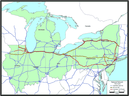
Source: FHWA, The Strategic Multimodal Analysis Task 3: Chicago-New York City Corridor Analysis using 2002 HPMS data.
Figure 1.2 Interstate 90 Corridor Exclusive Truck Lane Scenario
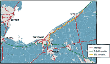
Source: National Transportation Atlas Database, 2008.
|
