U.S. Department of Transportation
Federal Highway Administration
1200 New Jersey Avenue, SE
Washington, DC 20590
202-366-4000
Table IN-2
October 2011
| ASIA | EUROPE | NORTH AMERICA | ||||||
|---|---|---|---|---|---|---|---|---|
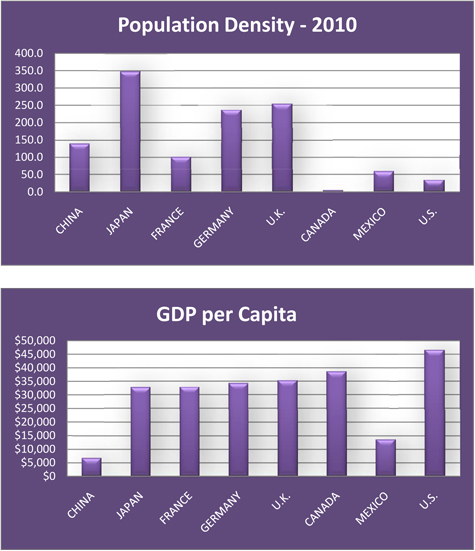
| CHINA |
JAPAN |
FRANCE |
GERMANY |
U.K. |
CANADA |
MEXICO |
U.S. |
|
| Population 1/ | 1,336,718,015 | 126,475,664 | 65,102,719 | 81,471,834 | 62,698,362 | 34,030,589 | 113,724,226 | 313,232,044 |
| Land Area 1/ (square kilometers) |
9,569,901 | 364,485 | 640,053 | 348,672 | 241,930 | 9,093,507 | 1,943,945 | 9,161,966 |
| Population Density (persons per square kilometer) |
139.7 | 347.0 | 101.7 | 233.7 | 259.2 | 3.7 | 58.5 | 34.2 |
| GDP (trillion $) 1/ (Purchasing Power Parity) |
$11.30 | $4.39 | $2.21 | $3.09 | $2.25 | $1.39 | $1.66 | $15.04 |
| GDP per Capita ($) 1/ (Purchasing power parity) |
$8,400 | $34,300 | $35,000 | $37,900 | $35,900 | $40,300 | $15,100 | $48,100 |
1/ Data source: "The World Fact Book" of the U.S. Central Intelligence Agency (CIA). Data for population is estimated as of July 2011, and 2010 for GDP data.